-
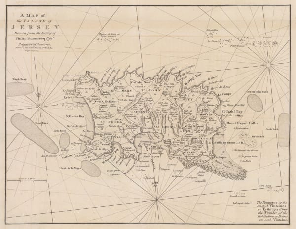
 John Cary, A Map of the Island of Jersey, 1805£ 395.00
 -
-
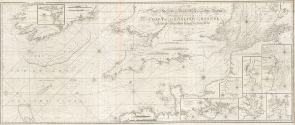
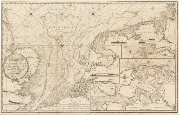
William Heather, New Chart of the Coasts of England and Holland from the Latest Surveys, 1805£ 1,750.00
-
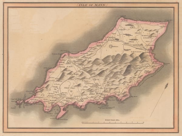
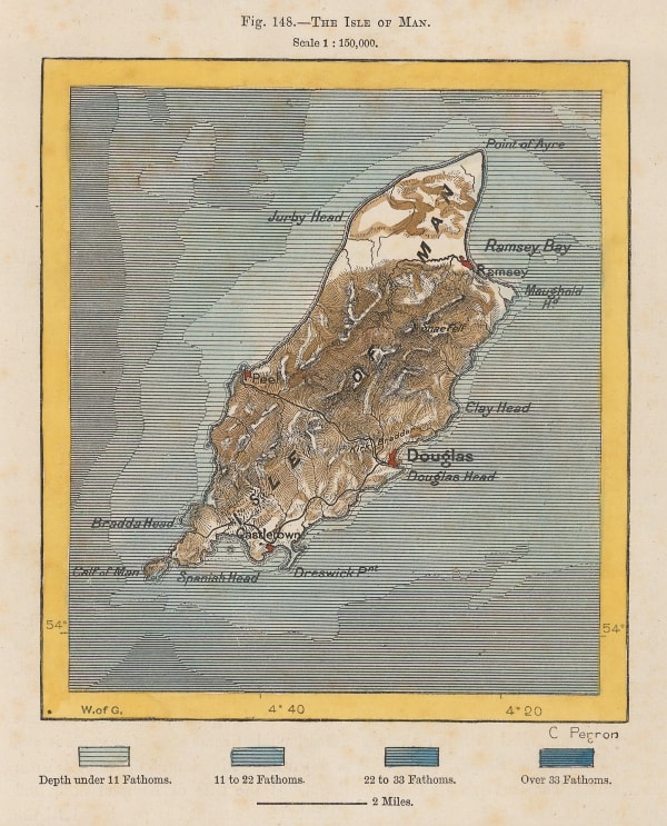
John Cary, Isle of Man, 1805£ 85.00
-
John Cary, A New Map of the British Isles, 1807£ 495.00
-
Robert Rowe, Wall Map of Great Britain and Ireland, 1810£ 975.00
-
C.V. Lavoisne, Geographical and Historical Map of Britain, 1813£ 325.00
-
John Pinkerton, Remote British Isles, 1814£ 225.00
-
John Thomson, Isle of Mann, 1815 c.£ 55.00
-
John Cary, Cary's Reduced Wall Map of Britain, 1818£ 2,200.00
-
John William Norie, A New Chart of the Coasts of England and Holland, 1824£ 2,250.00
-
Charles Smith, Smith's New Map of the United Kingdom, 1827£ 3,750.00
-
Sidney Hall, British Isles, 1830 c.£ 165.00
-
Edward Mogg, Mogg's Map of Steam Navigation, 1834£ 1,250.00
-
-
J. & C. Walker, A Geological Map of England, Wales, and Part of Scotland, 1837£ 4,500.00
-
Richard Holmes Laurie, Travelling Map of England and Scotland, 1839£ 275.00
-
Thomas Moule, The Isle of Man, 1840 c.£ 175.00
-
J. & C. Walker, Map of the British Isles, 1842£ 1,450.00
-
Ashford & Loader, Geological Map of England and Wales, 1844£ 625.00
-
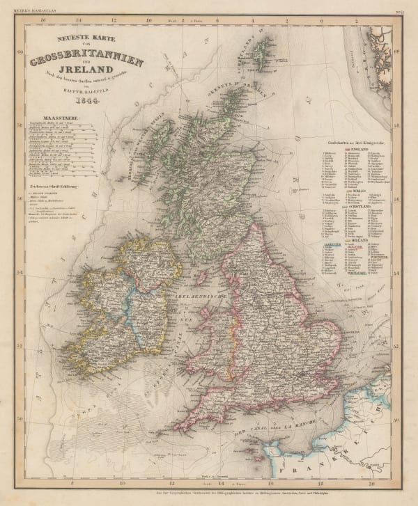
Joseph Meyer, New Map of Great Britain & Ireland, 1844£ 245.00
-
Ashford & Loader, Map and Sections of the Staffordshire Coal Field, 1845£ 125.00
-
James Wyld, Wall Map of Great Britain & Ireland, 1847£ 1,750.00
-
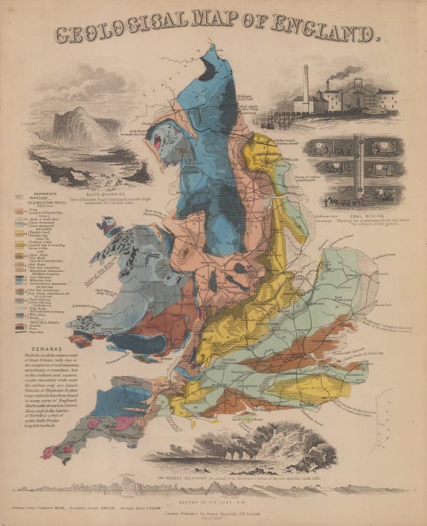
James Reynolds, Geological map of England, 1849£ 545.00
-
Alexander Keith Johnston, Paleontological Map of the British Isles, 1850 c£ 395.00
-
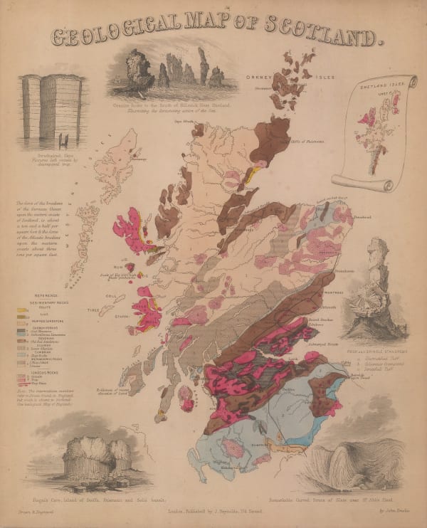
James Reynolds, Geological map of Scotland, 1850 c£ 545.00
-
John Rapkin, Channel Islands, 1850 c.£ 125.00
-
John Tallis, Channel Islands, 1851£ 295.00
-
-
John Tallis, The British Isles, 1851£ 695.00
-
John Ruthven, A Map of the English Lakes and Adjoining Country Geologically Coloured, 1855£ 345.00
-
George Philip, Isle of Man, 1856£ 95.00
-
Robert William Mylne, Geological and Topographical Map of London & its Environs, 1858£ 2,500.00
-
Aimé Thomé de Gamond, An Early Channel Tunnel Plan, 1858£ 950.00
-
Victor Levasseur, Great Britain, 1860£ 325.00
-
Archibald Fullarton, General Map of Channel Islands, 1860 c.£ 86.00
-
Archibald Fullarton, Isle of Man, 1860 c.£ 62.00
-
Archibald Fullarton, Railway Map of the British Isles, 1860 c.£ 325.00
-
Edward Stanford, Railway Map of the British Isles, 1866£ 385.00
-
James Imray, Bristol Channel, 1868£ 765.00
-
Alexander George Findlay, Chart of the North Sea, 1868£ 1,200.00
-
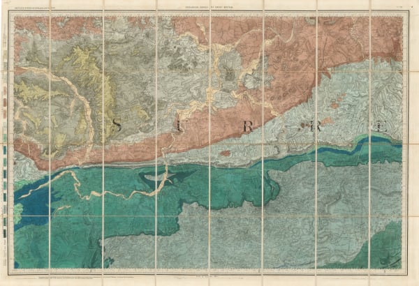
Ordnance Survey, Geological map of Western Surrey, 1868£ 375.00
-
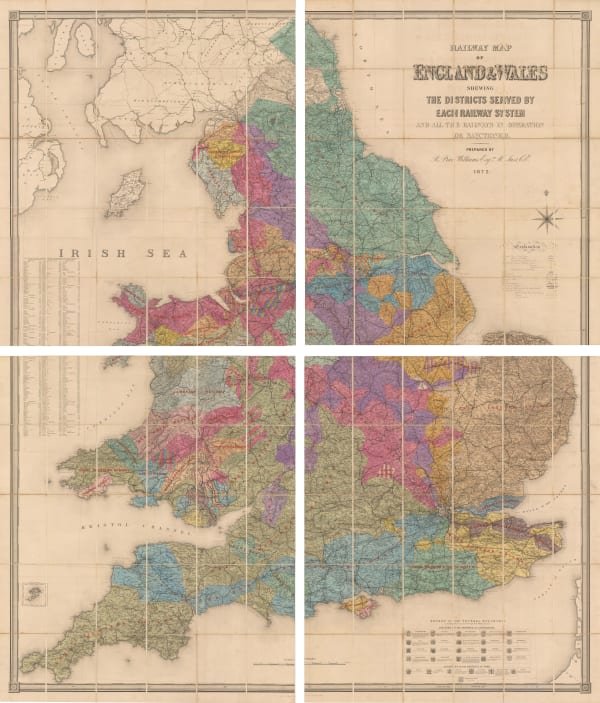
Edward Stanford, Railway Map of the England and Wales Shewing the Districts Served by Each Railway System, 1872£ 3,950.00
-
M.E. Daw, The British Isles, 1872£ 3,850.00
-
Board of Trade Wreck Register, Shipwreck Chart of Britain & Ireland, 1875£ 425.00
-
Board of Trade Wreck Register, Shipwreck Chart of Britain & Ireland, 1875£ 425.00
-
Society for the Diffusion of Useful Knowledge (SDUK), Geological Map of England and Wales, 1875£ 525.00
-
Society for the Diffusion of Useful Knowledge (SDUK), The British Isles, 1875£ 245.00
-
Sir Andrew Crombie Ramsay, Geological Map of England & Wales, 1876£ 925.00
-
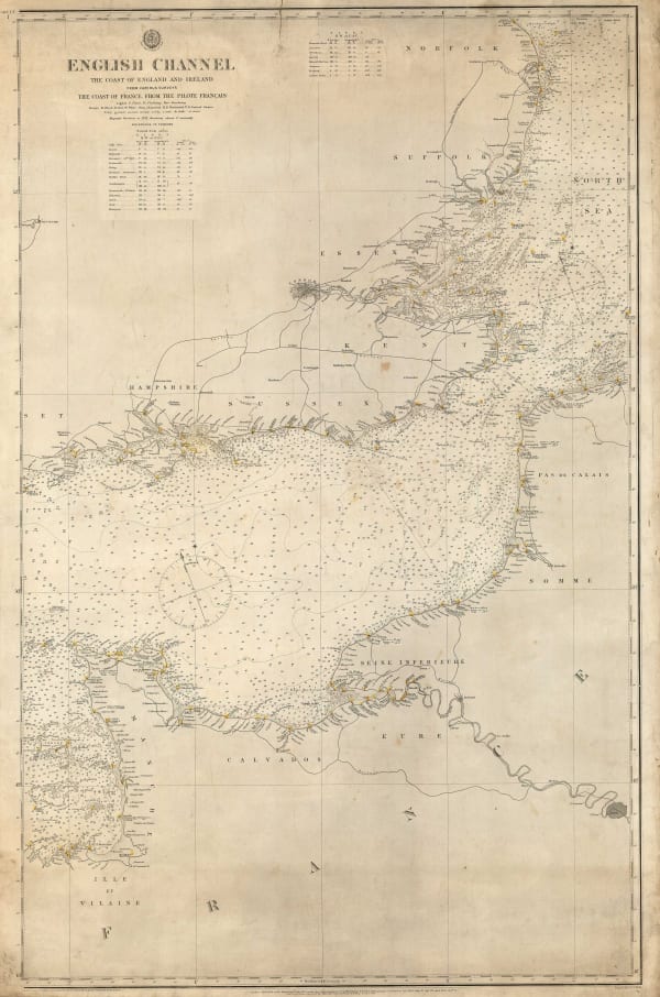
British Admiralty, English Channel, 1879£ 275.00
-
-
-
-
-
J. van Voorst, Geological Map of Surrey, 1880 c.£ 485.00
-
Ordnance Survey, Geological Survey of England and Wales, 1882£ 120.00
-
Ordnance Survey, Geological Survey of England and Wales, 1883£ 120.00
-
Ole Theodor Olsen, North Sea Bottom, 1883£ 185.00
-
Ole Theodor Olsen, North Sea Fishing Grounds, 1883£ 185.00
-
Ole Theodor Olsen, North Sea Soundings, 1883£ 185.00
-
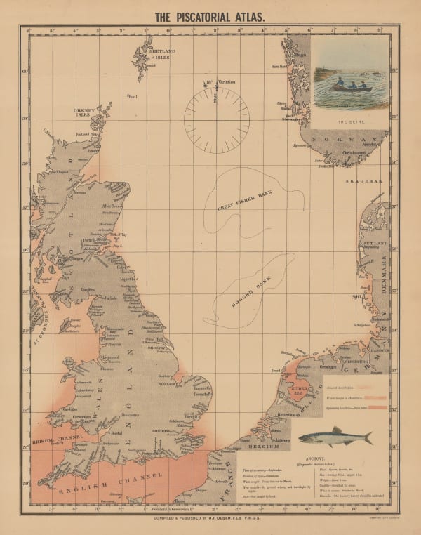
Ole Theodor Olsen, The Piscatorial Atlas - Anchovy, 1883£ 95.00
-
Ole Theodor Olsen, Sole Fishing in the North Sea, 1883£ 95.00
-
Ole Theodor Olsen, The Set of Tides at Half Ebb and Half Flood, 1883£ 185.00
-
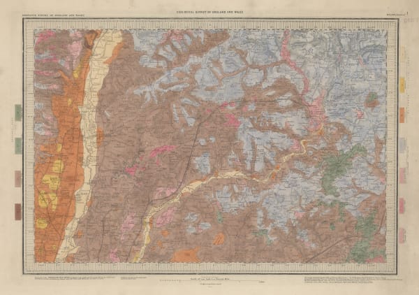
Ordnance Survey, Geological Survey of Great Britain, 1884£ 375.00
-
Ordnance Survey, Geological Survey of England and Wales, 1887£ 375.00
-
Ordnance Survey, Geological Survey of England and Wales, 1888£ 175.00
-
Ordnance Survey, Geological Survey of England and Wales, 1889£ 375.00
-
George Philip & Son Ltd., Geological Map of England and Wales, 1890£ 245.00
-
Ordnance Survey, Geological Survey of England and Wales, 1891£ 120.00
-
Ordnance Survey, Geological Survey of England and Wales, 1892£ 120.00
-
John Bartholomew & Co., Geological Map of Scotland, 1892£ 750.00
-
Ordnance Survey, Isle of Wight, 1893£ 325.00
-
Jean Jacques Élisée Reclus, The Isle of Man, 1894£ 45.00
-
Sir Archibald Geikie, Geological Map of the British Isles, 1896£ 3,500.00
-
Edward Stanford, The Channel Islands, 1896£ 75.00
-
Sir Archibald Geikie, Geological Map of England & Wales, 1897 (c.)£ 550.00
-
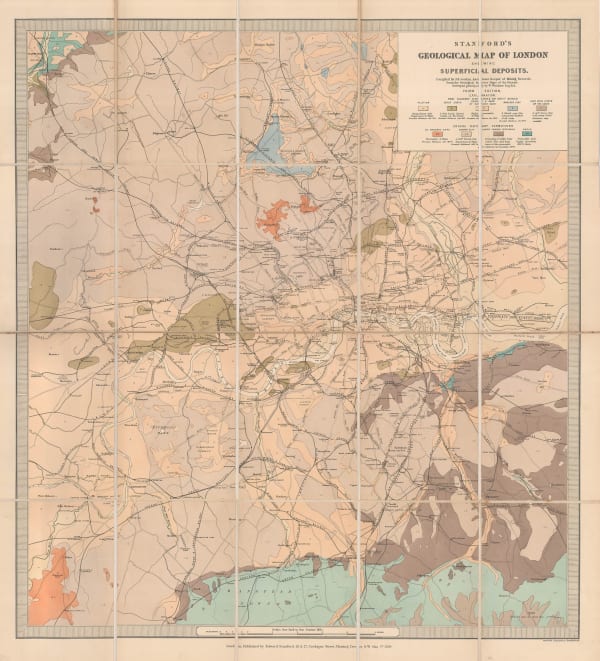
Edward Stanford, Stanford's Geological Map of London Shewing Superficial Deposits, 1899£ 425.00
-
Edward Stanford, The British Isles, 1900 c.£ 195.00
-
Geological Survey, Geological Map of London, 1904£ 725.00
-
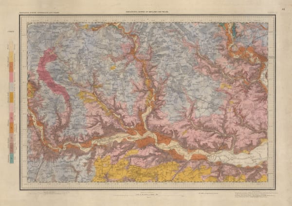
Ordnance Survey, Geological Survey of England and Wales, 1904£ 150.00


Page
2
of 3