-
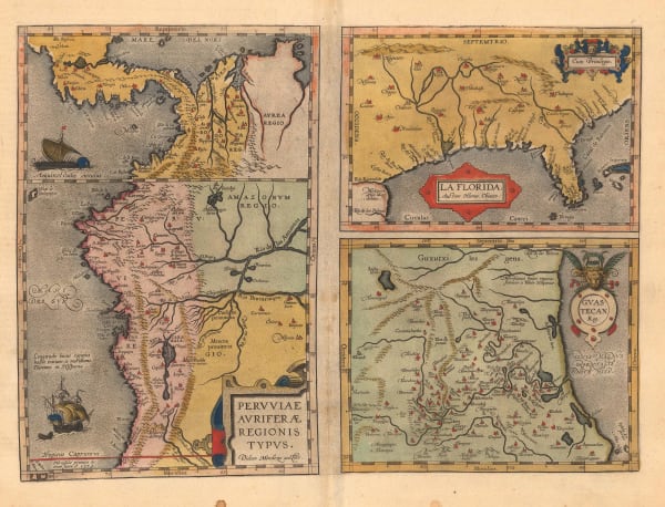
 Abraham Ortelius, La Florida, 1598£ 2,950.00
 -
Nicolas Sanson, Mexico and Central America, 1656£ 1,450.00
-
Alexandre Olivier Exquemelin, A Map of the Countrey and Citty of Panama, 1695 c.£ 950.00
-
Pierre Mortier, Carte Particuliere de Isthmus, ou Darien, qui comprend le Golfe de Panama, 1708£ 2,450.00
-
Herman Moll, Mexico, or New Spain, 1719£ 675.00
-
Jacques-Nicolas Bellin, Plan de la Baye et Ville de Portobelo, 1750 c.£ 175.00
-
Jacques-Nicolas Bellin, Plan de la Baye et Ville de Portobelo, 1754£ 175.00
-
Jacques-Nicolas Bellin, Baye de Porto Bello, 1764£ 195.00
-
Jacques-Nicolas Bellin, Baye de Porto-Belo et Costes Voisines, 1764£ 195.00
-
Jacques-Nicolas Bellin, Panama, 1764£ 425.00
-
Jacques-Nicolas Bellin, Chagres, Panama, 1764£ 125.00
-
Thomas Jefferys, A Map of the Isthmus of Darien and Bay of Panama, 1766£ 125.00
-
Thomas Jefferys, The Coast of New Spain from Neuva Vera Cruz to Triste Island, 1775£ 550.00
-
Thomas Jefferys, The Island of Jamaica and Cape Gracias a Dios with the Banks, 1775£ 350.00
-
Antonio Zatta, Messico ovvero Nuova Spagna, 1785£ 795.00
-
John Pinkerton, Spanish Dominions in North America, Southern Part, 1811£ 650.00
-
Depot de la Marine, Carte Reduite De La Mer Des Antilles, 1813£ 775.00
-
John Thomson, Spanish North America, Southern Part, 1816£ 495.00
-
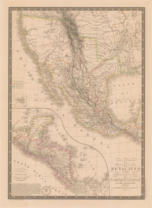
Adrien Brue, Carte Generale des Etats-Unis Mexicains et des Provinces-Unies de L'Amerique Centrale, 1825£ 375.00
-
Philippe Vandermaelen, Amer. Sep. Partie du Mexique et de Guatemala, 1827£ 350.00
-
Royal Geographical Society (RGS), Map of Central America, 1841£ 385.00
-
Henry Teesdale, Mexico and Guatimala, 1841£ 945.00
-
Thomas Kelly, Mexico & Guatemala, 1842£ 150.00
-
Samuel Augustus Mitchell, Mexico & Guatemala, 1849£ 185.00
-
John Tallis, Isthmus of Panama, 1851£ 325.00
-
John Tallis, Central America, 1851£ 385.00
-
Royal Geographical Society (RGS), Proposal for a Nicaragua Canal, 1851£ 175.00
-
Aimé Robiquet, Carte des Cotes de L'Amerique Centrale, 1852£ 725.00
-
Royal Geographical Society (RGS), Part of the Isthmus of Darien, 1853£ 140.00
-
Society for the Diffusion of Useful Knowledge (SDUK), Yucatan, Belize, Guatemala, Salvador, Honduras, Nicaragua and the southern states of Mexico, 1853£ 195.00
-
British Admiralty, Central America - West Coast, 1854£ 200.00
-
Royal Geographical Society (RGS), Isthmus of Darien, 1857£ 225.00
-
Royal Geographical Society (RGS), Sketch showing the Position of Lake Yojoa or Taulebe, also The Proposed Railway between the Bay of Honduras and the Bay of Fonseca to illustrate a Paper by E. G. Squier Esq. 1859, 1859£ 125.00
-
Archibald Fullarton, Central America, Namely the (Late) Confederated States of Central America; the Mexican States of Chiapa, Tabasco & Yucatan; and British Honduras, 1860 c.£ 325.00
-
Justus Perthes, Der Isthmus von San Blas, 1862£ 66.00
-
Royal Geographical Society (RGS), Map of the Mosquito Territory, From Surveys and Sketches - made during several years residence in the Country; by Chas. N. Bell. Esqr., 1862£ 185.00
-
Royal Geographical Society (RGS), The Isthmus of Panama to illustrate the Paper by Laurence Oliphant Esq., 1865£ 75.00
-
British Admiralty, Belize Harbour on the coast of Honduras by Comr. R. Owen in H. M. Ship Blossom 1830, 1866£ 785.00
-
Royal Geographical Society (RGS), Map of a Part of the Isthmus of Darien, 1867£ 195.00
-
Lucien Wyse, Carte Generale du Darien Meridional, 1877£ 595.00
-
Justus Perthes, Costa Rica, 1877£ 325.00
-
Royal Geographical Society (RGS), Plan of the Principal Group of Ruins at Copan, 1886£ 250.00
-
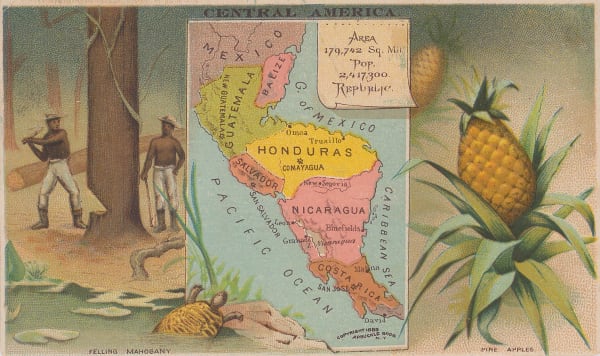
Arbuckle Brothers Company, Central America, 1889£ 125.00
-
Justus Perthes, Der Goldminen-Distrikte im ostlichen Nicaragua, 1893£ 68.00
-
Justus Perthes, Kartenskizze der Vulkane in West-Guatemala, 1895£ 68.00
-
Royal Geographical Society (RGS), Costa Rica, 1897£ 395.00
-
G. & J. Bartholomew, Mexico and Central America, 1897£ 48.00
-
Royal Geographical Society (RGS), North East Nicaragua, 1898£ 265.00
-
Julius Bien, Map Showing Line of Proposed Lock Canal, 1906£ 1,450.00
-
Royal Geographical Society (RGS), Map of Part of Guatemala, 1908£ 285.00
-
Royal Geographical Society (RGS), The Panama Canal, 1909£ 295.00
-
Enciclopedia Segui, Costa Rica, 1910 c.£ 55.00
-
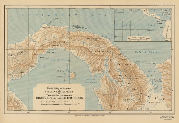
Royal Geographical Society (RGS), Vasco Nunez de Balboa's Discovery of the Pacific Ocean, 1913£ 78.00
-
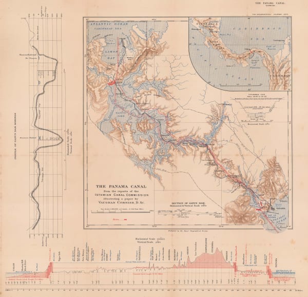
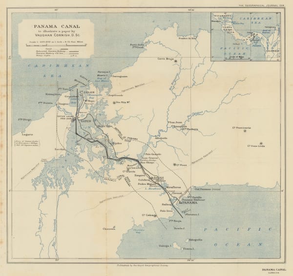
Royal Geographical Society (RGS), Panama Canal to illustrate a paper by Vaughan Cornish, 1914£ 345.00
-
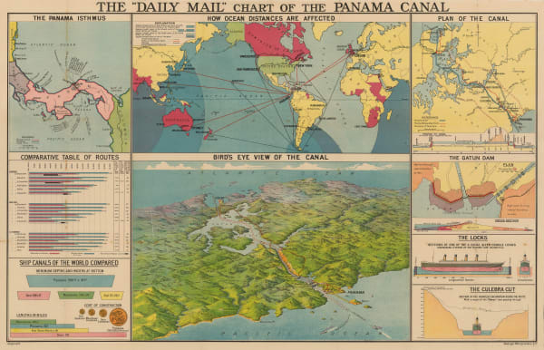
George Philip & Son Ltd., Chart of the Panama Canal, 1914 c.£ 495.00
-
I.L. Maduro Jr., Map of the Republic of Panama, 1915 c.£ 775.00
-
Royal Geographical Society (RGS), Belize (British Honduras), 1927£ 225.00
-
General Drafting Co., Mapa de la Republica de Costa Rica, 1965 (c.)£ 185.00
-
Jose Andres Masis, Mapa Turistico De Costa Rica, 1970£ 275.00
Close
Search Inventory
Our entire inventory of over 10,000 antique and vintage maps is now available to browse by region, date, cartographer, and subject


Join our mailing list
* denotes required fields
We will process the personal data you have supplied to communicate with you in accordance with our Privacy Policy. You can unsubscribe or change your preferences at any time by clicking the link in our emails.
![]()