-
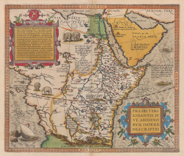
 Abraham Ortelius, The Empire of Prester John, 1595£ 3,450.00
 -
-
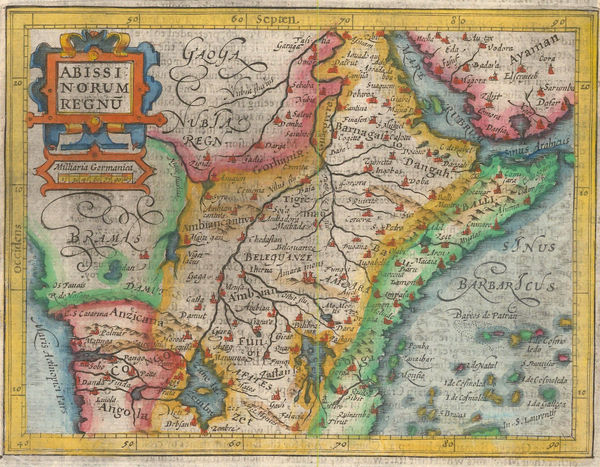
Samuel Purchas, Kingdom of Abyssinia, 1625£ 395.00
-
Matthäus Merian, The Empire of Prester John, 1644£ 825.00
-
Nicolas & Guillaume Sanson, Ethiopia & Nubia, 1692£ 245.00
-
Pierre Duval, Ethiopia & Sudan, 1694£ 225.00
-
Nicolas Sanson, East coast of Africa, 1700£ 475.00
-
Pierre Mortier, Chart of the coast of Mozambique, 1708£ 925.00
-
Covens (Jean) & Mortier (Cornelius), Southern & Central Africa, 1730 c.£ 1,250.00
-
Jacques-Nicolas Bellin, Chart of East Africa coast, 1740£ 275.00
-
Jacob van der Schley, Eastern Coast of Africa, 1747£ 245.00
-
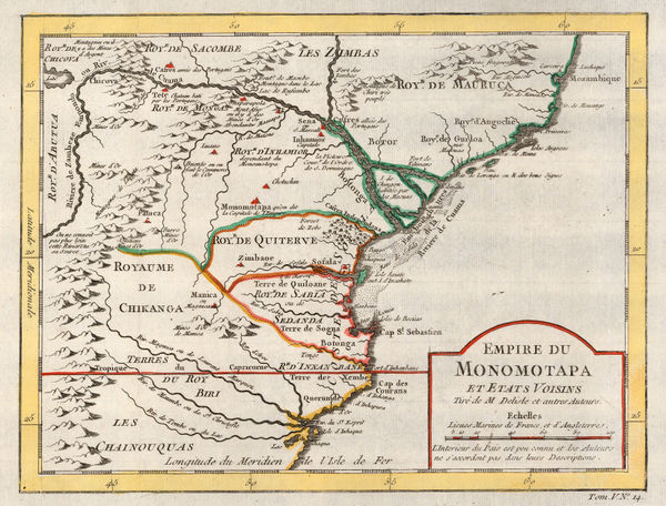
Jacques-Nicolas Bellin, Empire of Monomotapa (Mozambique), 1748£ 175.00
-
Charles Francois Delamarche, Southern & Central Africa, 1795£ 325.00
-
Adrien Brue, Southern Africa & the Cape Colony, 1828 c.£ 250.00
-
Royal Geographical Society (RGS), Southern Somalia, 1844£ 78.00
-
Royal Geographical Society (RGS), Southern Central Africa, 1856£ 225.00
-
Justus Perthes, Kenya and Tanzania, 1856£ 595.00
-
Royal Geographical Society (RGS), The Mythical Sea of Uniamesi &c., 1856£ 295.00
-
Royal Geographical Society (RGS), Burton & Speke's exploratory route in Tanzania, 1859£ 195.00
-
Justus Perthes, Speke's journey to Lake Victoria, 1859£ 175.00
-
Royal Geographical Society (RGS), Courses of the Zambezi and Shire rivers, 1861£ 125.00
-
Justus Perthes, Source of the Nile, 1863£ 125.00
-
Justus Perthes, Kilimanjaro and Kenya, 1864£ 325.00
-
W. & A.K. Johnston, Map of Eastern Equatorial Africa, 1864£ 975.00
-
Justus Perthes, Mt Kilimanjaro, 1864£ 95.00
-
Royal Geographical Society (RGS), The Discovery of Lake Albert, 1866£ 645.00
-
Royal Geographical Society (RGS), Caravan routes in Kenya and Tanzania, 1870£ 845.00
-
Map of Route from The Tati Settlement to Delagoa Bay, 1872Royal Geographical Society (RGS)Series: LondonRoyal Geographical Society (RGS), Map of Route from The Tati Settlement to Delagoa Bay, 1872£ 145.00
-
A Sketch map of Part of South Eastern Africa to Illustrate the Journeys of Dr Lacerda (1798) the Pombeiros (1806-11) and Major Monteiro (1831-32), 1873Royal Geographical Society (RGS)Series: LondonRoyal Geographical Society (RGS), A Sketch map of Part of South Eastern Africa to Illustrate the Journeys of Dr Lacerda (1798) the Pombeiros (1806-11) and Major Monteiro (1831-32), 1873£ 395.00
-
Royal Geographical Society (RGS), Slave Caravan Route, 1874£ 195.00
-
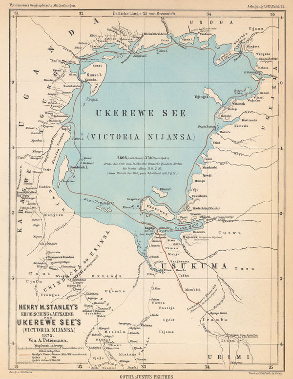
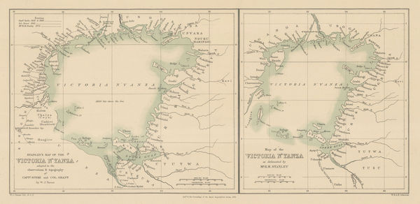
Justus Perthes, Lake Victoria according to Stanley, Speke & Grant, 1875£ 125.00
-
Royal Geographical Society (RGS), Route Map of the Gasa Country, 1875£ 175.00
-
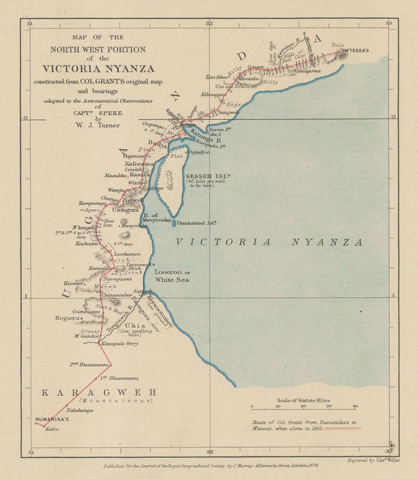
Royal Geographical Society (RGS), Lake Victoria and Uganda, 1876£ 110.00
-
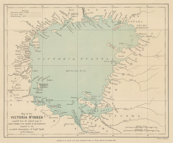
Lake Victoria according to Stanley, Speke & Grant, 1876Royal Geographical Society (RGS)Series: LondonRoyal Geographical Society (RGS), Lake Victoria according to Stanley, Speke & Grant, 1876£ 225.00
-
Lake Victoria according to Stanley, Speke & Grant, 1876Royal Geographical Society (RGS)Series: LondonRoyal Geographical Society (RGS), Lake Victoria according to Stanley, Speke & Grant, 1876£ 295.00
-
Royal Geographical Society (RGS), Map of the Upper Nile, 1877£ 72.00
-
Sketch Map of Native Routes from Dar Es Salaam Towards the Head of Lake Nyassa, 1879Royal Geographical Society (RGS)Series: LondonRoyal Geographical Society (RGS), Sketch Map of Native Routes from Dar Es Salaam Towards the Head of Lake Nyassa, 1879£ 125.00
-
Map of the Central Portion of South Africa Illustrating Dr. Holub's Journeys 1873-9, 1880Royal Geographical Society (RGS)Series: LondonRoyal Geographical Society (RGS), Map of the Central Portion of South Africa Illustrating Dr. Holub's Journeys 1873-9, 1880£ 165.00
-
James Stewart's route between Lake Malawi and Lake Tanganyika, 1880Royal Geographical Society (RGS)Series: LondonRoyal Geographical Society (RGS), James Stewart's route between Lake Malawi and Lake Tanganyika, 1880£ 125.00
-
Map of the Route of the R.G.S. East African Expedition to Lakes Nyassa & Tanganyika, 1880Royal Geographical Society (RGS)Series: LondonRoyal Geographical Society (RGS), Map of the Route of the R.G.S. East African Expedition to Lakes Nyassa & Tanganyika, 1880£ 225.00
-
Justus Perthes, Equatorial East Africa, 1881£ 675.00
-
Royal Geographical Society (RGS), Map of the Mozambique Coast, 1882£ 195.00
-
Royal Geographical Society (RGS), Large scale map of Mozambique, 1885£ 495.00
-
Royal Geographical Society (RGS), Mt Kilimanjaro, 1885£ 675.00
-
Scottish Geographical Society (SGS), Stanley's Emin Pasha Expedition, 1886£ 395.00
-
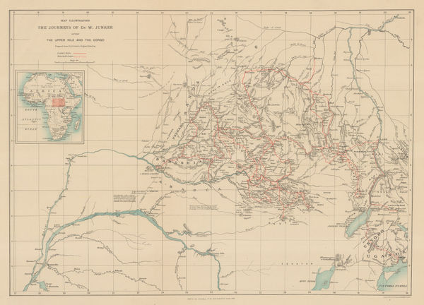
Royal Geographical Society (RGS), Junker's Travels in Congo & South Sudan, 1887£ 245.00
-
Mr. C.S.Smiths Journeys near Mombasa and from Kilwa to the Rovuma, 1887Royal Geographical Society (RGS)Series: LondonRoyal Geographical Society (RGS), Mr. C.S.Smiths Journeys near Mombasa and from Kilwa to the Rovuma, 1887£ 88.00
-
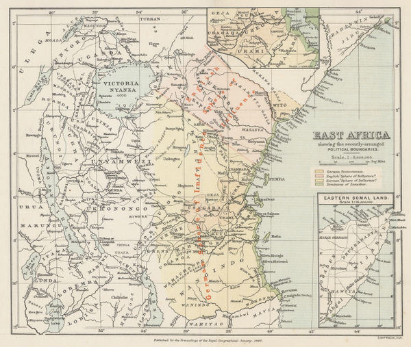
Royal Geographical Society (RGS), East Africa, 1887£ 545.00
-
Royal Geographical Society (RGS), Headwaters of the Congo and Nile Rivers, 1887£ 98.00
-
Map of Mr. F.C. Selous' Routes in the Matabele and Mashuna Countries, 1888Royal Geographical Society (RGS)Series: LondonRoyal Geographical Society (RGS), Map of Mr. F.C. Selous' Routes in the Matabele and Mashuna Countries, 1888£ 195.00
-
Scottish Geographical Society (SGS), Lake Malawi (Nyassa) to Lake Tanganyika, 1888£ 545.00
-
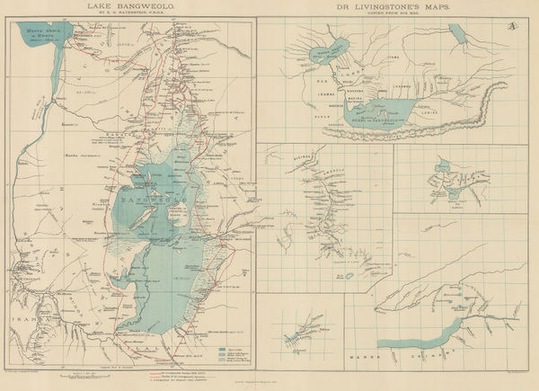
Royal Geographical Society (RGS), Livingstone's maps of Lake Bangweulu, Zimbabwe, 1889£ 145.00
-
Eastern Africa between the Rovuma and Zambesi Rivers, 1890Royal Geographical Society (RGS)Series: LondonRoyal Geographical Society (RGS), Eastern Africa between the Rovuma and Zambesi Rivers, 1890£ 495.00
-
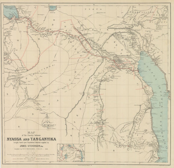
The Stevenson Road from Lake Malawi to Lake Tanganyika, 1890Scottish Geographical Society (SGS)Series: LondonScottish Geographical Society (SGS), The Stevenson Road from Lake Malawi to Lake Tanganyika, 1890£ 275.00
-
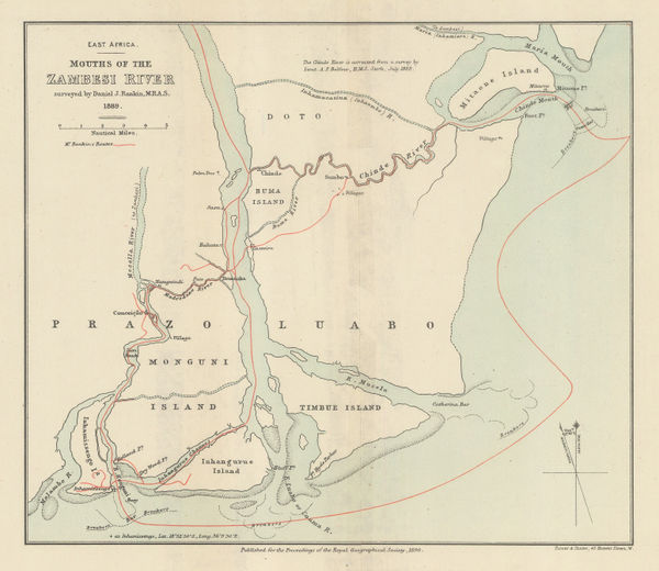
Royal Geographical Society (RGS), Mouths of the Zambesi River, 1890£ 88.00
-
Scottish Geographical Society (SGS), Stanley's Emin Pasha Expedition, 1890£ 775.00
-
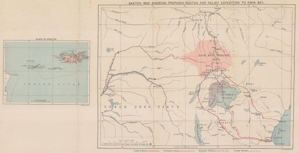
Sketch Map of the Route of the Emin Pasha Relief Expedition, 1890Royal Geographical Society (RGS)Series: LondonRoyal Geographical Society (RGS), Sketch Map of the Route of the Emin Pasha Relief Expedition, 1890£ 325.00
-
Scottish Geographical Society (SGS), Political Sketch-Map of Central Africa, 1890£ 595.00
-
Royal Geographical Society (RGS), Kilimanjaro, 1890£ 1,450.00
-
George W. Bacon, Bacon's Large-Print Map of South Africa, 1890 c.£ 775.00
-
Royal Geographical Society (RGS), Uganda & Western Kenya, 1891£ 185.00
-
Royal Geographical Society (RGS), The Progress of Exploration in East Africa, 1891£ 395.00
-
Imperial British East Africa (Kenya, Tanzania, Uganda), 1892Royal Geographical Society (RGS)Series: LondonRoyal Geographical Society (RGS), Imperial British East Africa (Kenya, Tanzania, Uganda), 1892£ 545.00
-
German missionary expeditions in north Malawi and southwest Tanzania, 1892Justus PerthesSeries: GothaJustus Perthes, German missionary expeditions in north Malawi and southwest Tanzania, 1892£ 68.00
-
Royal Geographical Society (RGS), Western Uganda, 1892£ 325.00
-
Royal Geographical Society (RGS), Malawi and Zambia, 1893£ 145.00
-
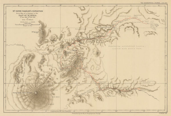
Wm. Astor Chanler's Expedition Route Map of a Journey to the East of Mt. Kenia, 1893Royal Geographical Society (RGS)Series: LondonRoyal Geographical Society (RGS), Wm. Astor Chanler's Expedition Route Map of a Journey to the East of Mt. Kenia, 1893£ 160.00
-
Royal Geographical Society (RGS), Mombasa-Victoria Lake Railway, 1893£ 545.00
-
Map of Part of British and German East Africa including the British Protectorate of Uganda, 1894War OfficeSeries: LondonWar Office, Map of Part of British and German East Africa including the British Protectorate of Uganda, 1894£ 1,650.00
-
Royal Geographical Society (RGS), Map of Part of East Africa, 1895£ 190.00
-
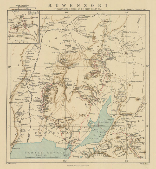
Royal Geographical Society (RGS), Rwenzori Mountains, Congo - Uganda border, 1895£ 185.00
-
Justus Perthes, Kenya, Uganda and Tanzania, 1895£ 895.00
-
Justus Perthes, Mt Kenya to Mt Kilimanjaro, 1896£ 195.00
-
Royal Geographical Society (RGS), Zambia & Victoria Falls, 1897£ 145.00
-
Royal Geographical Society (RGS), Uganda & Western Kenya, 1897£ 385.00
-
Royal Geographical Society (RGS), Eastern Zambia, 1898£ 135.00
-
Royal Geographical Society (RGS), Lake Turkana (Rudolf), Kenya, 1898£ 125.00
-
Royal Geographical Society (RGS), Uganda and western Kenya, 1899£ 265.00
-
Royal Geographical Society (RGS), Survey map between Lakes Tanganyika and Malawi, 1899£ 295.00
-
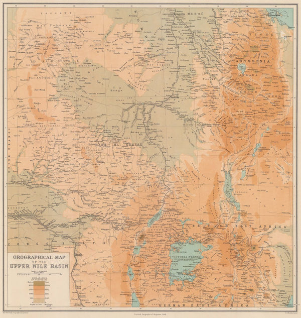
Scottish Geographical Society (SGS), Orographical Map of the Upper Nile Basin, 1899£ 195.00


Page
1
of 2