-
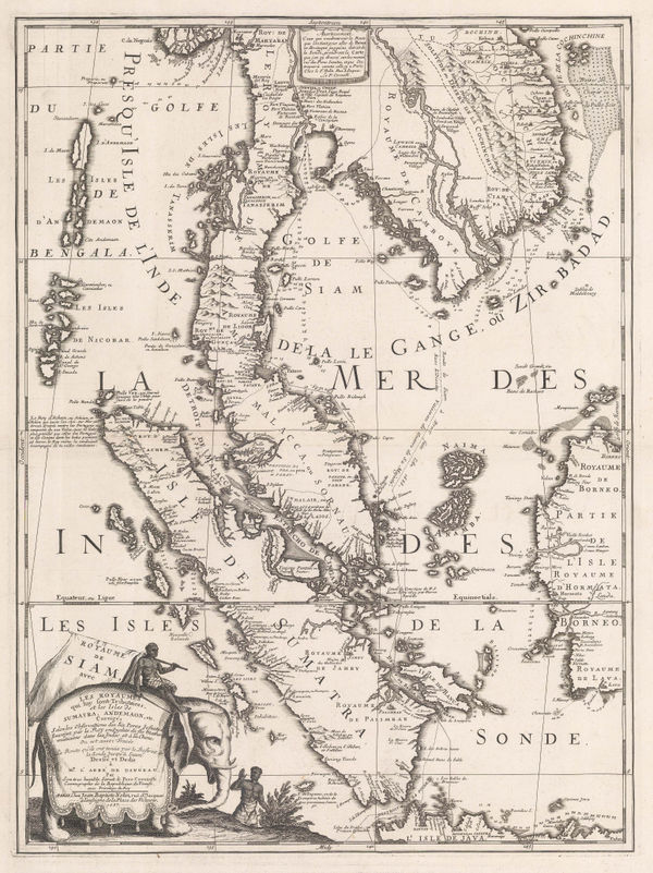
 Laurent Fries, Early Map of Southeast Asia, 1541£ 4,250.00
 -
-
Girolamo Ruscelli, Early map of Southeast Asia, 1574£ 885.00
-
Tomaso Porcacchi, Early map of Southeast Asia, 1576£ 820.00
-
Samuel Purchas, Early map of South East Asia, 1625£ 485.00
-
Mercator Hondius, Early map of Southeast Asia, 1628£ 495.00
-
Mercator Hondius, Southeast Asia, 1632£ 825.00
-
-
Matthäus Merian, South East Asia, 1646£ 1,250.00
-
Jan Jansson, Dutch Golden Age map of Borneo, 1657£ 2,250.00
-
Nicolas & Guillaume Sanson, New Guinea and the Moluccas (Maluku Islands), 1683£ 295.00
-
-
Robert Morden, Borneo, Sumatra, Java and Malacca, 1688£ 225.00
-
Robert Morden, Early map of the Moluccas or Maluku Islands, 1688£ 195.00
-
Vincenzo Coronelli, North Maluku Islands, 1692£ 550.00
-
Nicolas Sanson, Sumatra, Java and Borneo, 1692£ 695.00
-
Pierre Duval, Indonesia, 1694 c.£ 345.00
-
Vincenzo Coronelli, Early map of the Banda Islands, 1696£ 295.00
-
Vincenzo Coronelli, Italian map of Southeast Asia, 1696 c.£ 2,750.00
-
-
Valk & Schenk, Sumatra and Singapore Straits, 1700 c.£ 2,000.00
-
Nicolas de Fer, Scarce map of Southeast Asia, 1702£ 885.00
-
-
Heinrich Scherer, Southeast Asia, 1709£ 1,850.00
-
Heinrich Scherer, Southeast Asia, 1709£ 845.00
-
Valk & Schenk, Chart of Java, 1710 c.£ 885.00
-
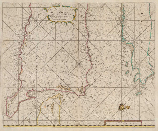
Samuel Thornton, Java, Madura and the Straights of Bali, 1711£ 665.00
-
Samuel Thornton, Chart of Southern Borneo, 1711£ 320.00
-
Pieter van der Aa, Sumatra and the Strait of Singapore, 1714£ 445.00
-
Pieter van der Aa, Sulawesi, Maluku Islands and West Papua, 1714£ 395.00
-
Pieter van der Aa, Straits of Sunda, 1714£ 345.00
-
Pieter van der Aa, Chart of the Banda Islands, 1714£ 985.00
-
Josua & Reinier Ottens, Sumatra, Java, and Borneo, 1720 c.£ 1,250.00
-
François Valentyn, Sumatra and southern Malay Peninsula , 1720 c.£ 2,200.00
-
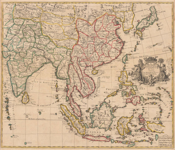
John Senex, A New Map of India & China from the Latest Observations, 1721£ 2,850.00
-
Herman Moll, The Principal Islands of the East Indies, 1723£ 375.00
-
François Valentyn, First large scale map of Bali, 1726£ 1,450.00
-
François Valentyn, Important map of Borneo , 1727£ 2,450.00
-
Covens (Jean) & Mortier (Cornelius), Borneo, 1730 c£ 545.00
-
Henri du Sauzet, Southeast Asia, 1734£ 675.00
-
Isaac Tirion, Southeast Asia, 1744£ 345.00
-
Johann Wolfgang Heydt, Sunda Straits and Jakarta, 1744£ 595.00
-
Johann Wolfgang Heydt, Plan of Jakarta (Batavia), 1744£ 495.00
-
Johann Wolfgang Heydt, Plan of Jakarta (Batavia), 1744£ 495.00
-
Jakarta and the archipelago of Thousand Islands (Kepulauan Seribu), 1745Awnsham & John ChurchillSeries: LondonAwnsham & John Churchill, Jakarta and the archipelago of Thousand Islands (Kepulauan Seribu), 1745£ 195.00
-
Jacques-Nicolas Bellin, China, Japan, Philippines & Southeast Asia, 1746£ 445.00
-
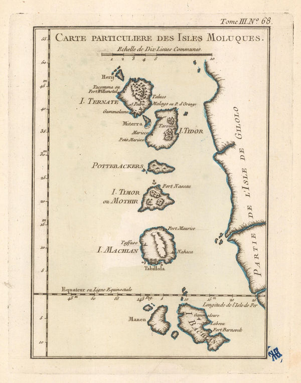
Georges-Louis Le Rouge, Isles Moluques, 1748 c.£ 345.00
-
Jacques-Nicolas Bellin, Chart of Malaysia, Borneo, Java and Sumatra, 1749£ 465.00
-
Jacques-Nicolas Bellin, Ceram, Buru, Ambon and Banda Neira, 1750£ 185.00
-
Jacques-Nicolas Bellin, Jakarta, 1750£ 645.00
-
Herman Moll, Philippines, Indonesia and Malaysia, 1755 c.£ 495.00
-
Jacques-Nicolas Bellin, Sumatra and the Malacca Straits, 1760£ 450.00
-
Jacob van der Schley, Jakarta (Batavia), 1760 c.£ 525.00
-
Jacques-Nicolas Bellin, French map of Java, 1764£ 345.00
-
Ternate, Tidore, Mare, Moti, Makia and Bacan, North Maluku Islands, 1764Jacques-Nicolas BellinSeries: ParisJacques-Nicolas Bellin, Ternate, Tidore, Mare, Moti, Makia and Bacan, North Maluku Islands, 1764£ 125.00
-
Jacques-Nicolas Bellin, The Philippines and Indonesia, 1764£ 525.00
-
Jacques-Nicolas Bellin, Jakarta, 1764£ 325.00
-
Jacques-Nicolas Bellin, Sumatra, Singapore & Malaysia, 1764£ 395.00
-
Willem Albert Bachiene, Southeast Asia, 1774£ 1,250.00
-
Robert Sayer, A Chart of the Straits of Sunda and Banca, 1778£ 775.00
-
Thomas Conder, East Indies, 1778£ 895.00
-
Francois Santini, Southeast Asia, 1778£ 525.00
-
Antonio Zatta, South East Asia, 1780£ 325.00
-
Philippines with parts of part of Indonesia, New Guinea, Taiwan and southeast China, 1780 cRigobert BonneRigobert Bonne, Philippines with parts of part of Indonesia, New Guinea, Taiwan and southeast China, 1780 c£ 550.00
-
Jean-Baptiste d'Après de Mannevillette, Sea Chart of Java, Indonesia, 1780 c.£ 925.00
-
Rigobert Bonne, Indonesia, Malaysia and New Guinea, 1790 c£ 395.00
-
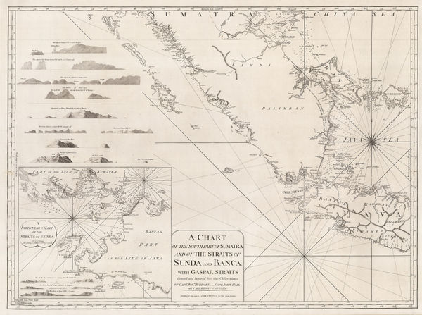
A Chart of the Southern Part of Sumatra and of the Straits of Sunda and Banca, 1794Laurie & WhittleSeries: LondonLaurie & Whittle, A Chart of the Southern Part of Sumatra and of the Straits of Sunda and Banca, 1794£ 925.00
-
Laurie & Whittle, Bali Strait, 1794£ 395.00
-
Laurie & Whittle, Chart of the west Coast of Sumatra, 1794£ 495.00
-
Laurie & Whittle, Chart of the Riau Islands in the Singapore Strait, 1794£ 1,250.00
-
Charles Francois Delamarche, Southeast Asia, 1795£ 375.00
-
-
William Heather, Two charts of Islands in the Banda Sea, 1800£ 2,950.00
-
George Cooke, Southeast Asia, 1800£ 175.00
-
William Heather, Georgian chart of the Sunda Straits, 1803£ 1,950.00
-
A New Chart Shewing the Navigation through the Sunda Straights to Batavia, 1803William HeatherSeries: LondonWilliam Heather, A New Chart Shewing the Navigation through the Sunda Straights to Batavia, 1803£ 2,950.00
-
Aaron Arrowsmith, Chart of the East India Islands, 1808£ 375.00
-
John Pinkerton, East India Isles, 1813£ 985.00
-
John Thomson, Southeast Asia, 1815 c.£ 495.00
-
John Cary, Southeast Asia, 1825£ 645.00


Page
1
of 2