-
 James Cowles Prichard, Ethnographic Map of North America, 1861£ 550.00
 -
F.A. Garnier, Civil War map of the United States, 1862 c£ 595.00
-
James T. Lloyd, Railroad, Telegraph and Express Map of the United States, 1864£ 2,750.00
-
General Land Office (GLO), Map of the United States and Territories, 1866£ 4,000.00
-
Map of the United States of America, the British Provinces, Mexico and the West Indies, 1868 c.George Woolworth ColtonSeries: New YorkGeorge Woolworth Colton, Map of the United States of America, the British Provinces, Mexico and the West Indies, 1868 c.£ 2,850.00
-
James Wyld, The United States, 1870 (c.)£ 1,250.00
-
Heinrich C. Kiepert, Die Vereinigten Staaten von Nord America nebst Canada, 1870 c.£ 445.00
-
Justus Perthes, Coalfields of the United States, 1875£ 125.00
-
Adrien Brue, Carte de L'Amerique Septentrionale, 1876£ 175.00
-
Blackie & Son, The United States of North America, 1880 c.£ 125.00
-
O.W. Gray & Son, New Map of the United States, 1881£ 385.00
-
Paul Brodie, Indian Reservations, 1885£ 950.00
-
Justus Perthes, [United States & Mexico], 1885£ 475.00
-
George W. Bacon, North America, 1885 (c.)£ 125.00
-
J.G. Bartholomew, United States, 1887£ 50.00
-
Lyman Brown, Lyman Brown's Seven Barks - Pictorial Map of the United States, 1888£ 695.00
-
Justus Perthes, Population map of the United States and Canada, 1888£ 325.00
-
Arbuckle Brothers Company, United States, 1889£ 195.00
-
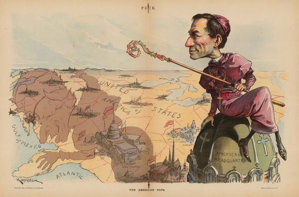
Keppler and Schwarzmann, The American Pope, 1894£ 1,900.00
-
Emil Reich, The Seven Years' War in Europe and America, 1903£ 65.00
-
Geographical Publishing Co., Intermediate Series: United States, 1906£ 575.00
-
Map Showing Indian Reservations within the Limits of the United States, 1907Francis Ellington LeuppSeries: Washington, D.C.Francis Ellington Leupp, Map Showing Indian Reservations within the Limits of the United States, 1907£ 945.00
-
George Philip & Son Ltd., Industrial North America with Communications, 1910 c.£ 175.00
-
Edward Stanford, Railway Map of the US & Canada, 1913£ 1,450.00
-
Indian Reservations in the United States, 1915, 1915United States Geological Survey (USGS)Series: Washington, D.C.United States Geological Survey (USGS), Indian Reservations in the United States, 1915, 1915£ 525.00
-
G. Delattre & Cie., First World War French propaganda poster, 1917 c.£ 825.00
-
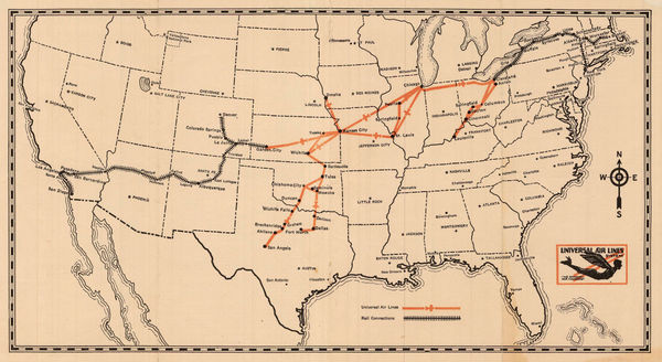
Universal Aviation, Universal Air Lines System, 1929£ 445.00
-
Ernest Dudley Chase, The United States of America, 1935£ 1,450.00
-
Principal Crude Oil, Gas and Refined Product Pipelines of the United States, 1946Oil WeeklySeries: Houston, TexasOil Weekly, Principal Crude Oil, Gas and Refined Product Pipelines of the United States, 1946£ 2,950.00
-
Air France, Air France Postcard - 'Amerique du Nord', 1946 c.£ 250.00
-
Ernest Dudley Chase, The Pictorial Map Stamps of America, 1947 c.£ 950.00
-
Oren Arnold, Map of the United States as Arizonans See It, 1952£ 675.00
-
Franklin Scott, Exploration and Western Expansion 1804-1844, 1954£ 445.00
-
Franklin Scott, Territorial Expansion to 1848: The Mexican War, 1954£ 345.00
-
Franklin Scott, The United States at the Beginning of the Civil War 1861, 1954£ 345.00


![Justus Perthes, [United States & Mexico], 1885](https://static-assets.artlogic.net/w_600,c_limit,f_auto,fl_lossy,q_auto/artlogicstorage/themaphouse/images/view/c6625ff623e11a6f202de768c609d824j/themaphouse-justus-perthes-united-states-mexico-1885.jpg)


Page
2
of 2