-
 Sebastian Münster, Great Britain and Ireland, 1588£ 245.00
 -
Matthias Quad, Angliae reni florentissimi noua descriptio, 1609£ 850.00
-
John Speed, The Kingdome of England, 1614£ 3,750.00
-
Mercator Hondius, Southeast England, 1621£ 195.00
-
David Custodis, Uncommon Map of the British Isles, 1627£ 595.00
-
Mercator Hondius, Angliae III Tabvla, 1628£ 165.00
-
Mercator Hondius, Southwest England & South Wales, 1635£ 225.00
-
Willem & Jan Blaeu, England and Wales, 1648£ 750.00
-
John Speed, Anglo-Saxon Britain, 1676£ 4,750.00
-
Vincenzo Coronelli, Kingdom of England, 1692 c.£ 1,250.00
-
Nicolas Sanson, England during the Anglo-Saxon Heptarchy, 1700£ 475.00
-
Herman Moll, England & Wales, 1708£ 375.00
-
Thomas Bowles, A Draught of the River Thames, 1710£ 850.00
-
Herman Moll, England & Wales, 1710£ 2,650.00
-
Pieter van der Aa, L'Angleterre, 1713£ 575.00
-
Pieter van der Aa, L'Angleterre, 1714£ 445.00
-
Christoph & Johann Christoph Weigel, Anglia Cambdeni, 1720 c.£ 295.00
-
Giambattista Albrizzi, Nuova Carta dell'Isole Britanniche, 1750 (c.)£ 395.00
-
The Roads of ye South Part of Great Britain, called England and Wales ..., 1755 c.Herman MollSeries: LondonHerman Moll, The Roads of ye South Part of Great Britain, called England and Wales ..., 1755 c.£ 575.00
-
Jacques-Nicolas Bellin, English Channel, 1764£ 245.00
-
Jacques-Nicolas Bellin, England and Wales, 1764£ 145.00
-
Étienne André Philippe de Prétot, L'Angleterre, 1770£ 295.00
-
Thomas Kitchin, An Accurate Map of England and Wales, 1770 c.£ 375.00
-
Antonio Zatta, Li Regni d'Inghilterra e d'Irlanda, 1776£ 385.00
-
Emanuel Bowen, Kitchin's Enlarged Map of the Roads of England & Wales, 1779£ 395.00
-
Thomas Bowen, A New and Accurate Map of England, 1780 (c.)£ 245.00
-
John Rocque, England and Wales, 1780 c.£ 1,750.00
-
Franz Von Reilly, Das Konigreich England Nach Kitchin, 1795£ 380.00
-
Geography Bewitched! or, a droll Caricature map of England & Wales, 1797Robert DightonSeries: LondonRobert Dighton, Geography Bewitched! or, a droll Caricature map of England & Wales, 1797£ 4,000.00
-
Robert Wilkinson, Roman Britain, 1800£ 165.00
-
Robert Wilkinson, Saxon England, 1800£ 185.00
-
Robert Wilkinson, Roman Britain, 1800£ 145.00
-
William Faden, A Map of England, Wales and Scotland, 1801£ 825.00
-
Charles Smith, The Lake District, 1802£ 485.00
-
John Cary, Map of England and Wales, 1803£ 485.00
-
A Map of the Principal Roman Camps, Forts and Walls & c between the River Tyne in England and Tay in Scotland, 1805John CarySeries: LondonJohn Cary, A Map of the Principal Roman Camps, Forts and Walls & c between the River Tyne in England and Tay in Scotland, 1805£ 145.00
-
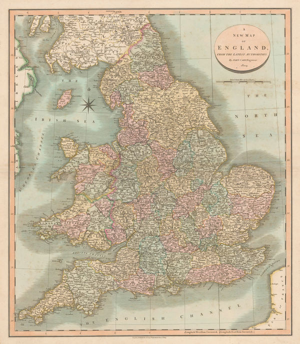
John Cary, A New Map of England, 1809£ 345.00
-
Daniel Paterson, New Four Sheet Map of England and Wales, 1810£ 1,850.00
-
Langley & Belch, England and Wales, 1817£ 445.00
-
William Darton, Travelling Companion through England and Wales, 1819£ 395.00
-
Jonathan Hebner, The Grand Southern Tour of England, 1821£ 1,250.00
-
Henry Teesdale, England and Wales, 1830 c.£ 295.00
-
Robert Seaton, New Map of England and Wales, 1830 c.£ 3,500.00
-
George & John Cary, London & the Home Counties, 1832£ 1,450.00
-
Cary's Six Sheet Map of England and Wales, with part of Scotland, 1833George & John CarySeries: LondonGeorge & John Cary, Cary's Six Sheet Map of England and Wales, with part of Scotland, 1833£ 850.00
-
Edward Mogg, New Map of England and Wales with Part of Scotland, 1835£ 1,350.00
-
J. & C. Walker, A Geological Map of England, Wales, and Part of Scotland, 1837£ 4,500.00
-
Commencement of the Roads to Holyhead, as far as (13) Stratford on Avon, Warwick, Coventry & Hinckley, 1838Richard Holmes LaurieSeries: LondonRichard Holmes Laurie, Commencement of the Roads to Holyhead, as far as (13) Stratford on Avon, Warwick, Coventry & Hinckley, 1838£ 45.00
-
Ordnance Survey, 20 Miles Around Chesterfield, 1839£ 295.00
-
Samuel Lewis, A Map of England and Wales, 1840£ 1,450.00
-
J. & C. Walker, England and Wales, 1840£ 1,250.00
-
Ordnance Survey, The Peak District, 1841 (c.)£ 150.00
-
Charles Frederick Cheffins, Map of the English and Scottish Railways, 1843£ 475.00
-
Society for the Diffusion of Useful Knowledge (SDUK), Ancient Britain, 1843£ 95.00
-
Map of the Railways Showing the Various Stations with the Hills, Rivers, Canals and Principal Roads of England and Wales, 1845Aaron ArrowsmithSeries: LondonAaron Arrowsmith, Map of the Railways Showing the Various Stations with the Hills, Rivers, Canals and Principal Roads of England and Wales, 1845£ 2,450.00
-
James Wyld, Railway Map of England Wales and Scotland, 1845£ 1,850.00
-
Thomas Turner, Victorian Board Game map of England & Wales, 1845 (c.)£ 1,850.00
-
James Wyld, A Map of England, Wales & Scotland, 1845 c.£ 595.00
-
James Reynolds, Geological map of England, 1849£ 545.00
-
Wallis's Picturesque Round Game of the Produce and Manufactures of the Counties of England and Wales, 1850 c.Edward WallisSeries: LondonEdward Wallis, Wallis's Picturesque Round Game of the Produce and Manufactures of the Counties of England and Wales, 1850 c.£ 1,250.00
-
John Tallis, Tallis's Railway Map of Great Britain, 1851£ 475.00
-
John Tallis, England and Wales, 1855£ 495.00
-
Victor Levasseur, Carte Administrative et Physique de L'Angleterre, 1860 c.£ 175.00
-
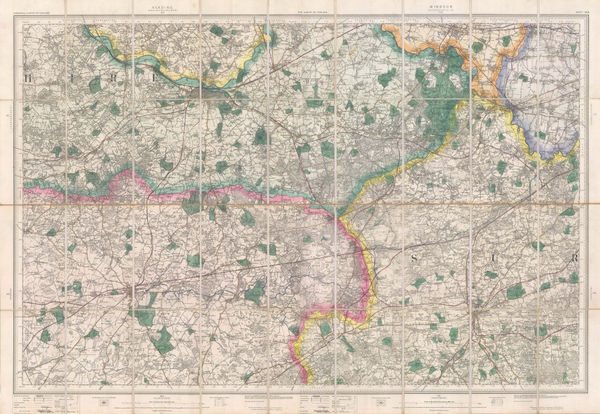
Ordnance Survey, England - Warwick to Suffolk, 1863£ 645.00
-
Cassell, Petter & Galpin, The River Thames: From the Source to the Sea, 1863£ 185.00
-
Ordnance Survey, England - Leicestershire to Norfolk, 1864£ 645.00
-
Ordnance Survey, England - Lincolnshire, Nottinghamshire & Norfolk, 1864£ 645.00
-
Aleph, England, 1869£ 1,950.00
-
Railway Map of the England and Wales Shewing the Districts Served by Each Railway System, 1872Edward StanfordSeries: LondonEdward Stanford, Railway Map of the England and Wales Shewing the Districts Served by Each Railway System, 1872£ 3,950.00
-
Ordnance Survey, Wimborne, Blandford, Shaftesbury, Lynhurst, Salisbury & Ringwood, 1872£ 295.00
-
Ordnance Survey, Warminster, Devizes, Marlborough & Amesbury, 1872£ 195.00
-
Chart Shewing the Wrecks & Casualties on the Coasts of England & Wales, 1875Board of Trade Wreck RegisterSeries: LondonBoard of Trade Wreck Register, Chart Shewing the Wrecks & Casualties on the Coasts of England & Wales, 1875£ 345.00
-
Edward Stanford, Railway and Road Map of England and Wales, 1875£ 485.00
-
Sir Andrew Crombie Ramsay, Geological Map of England & Wales, 1876£ 725.00
-
Ordnance Survey, Bristol, the Cotswolds, Chepstow & the Severn, 1880£ 295.00
-
Ordnance Survey, Bath & Chippenham (Sheet 265), 1880 (c.)£ 125.00
-
The General Election 1892 & The Graphic Parliamentary Map [Sold as a Pair], 1892The Graphic MagazineSeries: LondonThe Graphic Magazine, The General Election 1892 & The Graphic Parliamentary Map [Sold as a Pair], 1892£ 950.00
-
Ordnance Survey, The Country around Faringdon, 1895£ 295.00
-
Ordnance Survey, The Country around High Wycombe, 1895£ 295.00
-
Ordnance Survey, The Country around Sandhurst, 1895£ 295.00


![The Graphic Magazine, The General Election 1892 & The Graphic Parliamentary Map [Sold as a Pair], 1892](https://static-assets.artlogic.net/w_600,c_limit,f_auto,fl_lossy,q_auto/artlogicstorage/themaphouse/images/view/482cbe78e7901f3a280f8da45f96c026j/themaphouse-the-graphic-magazine-the-general-election-1892-the-graphic-parliamentary-map-sold-as-a-pair-1892.jpg)


Page
1
of 2