-
 Tomaso Porcacchi, Ireland, 1604£ 675.00
 -
John Speed, Decorative map of Ireland, 1614£ 3,750.00
-
Mercator Hondius, Northern and Southern Parts of Ireland, 1628£ 675.00
-
Mercator Hondius, Irlandiae Regnum, 1633£ 1,850.00
-
William Hole, Hibernia, 1637£ 1,250.00
-
Willem & Jan Blaeu, Dutch Golden Age map of Ireland, 1640 c.£ 950.00
-
Pieter van der Aa, Ireland, 1714£ 395.00
-
Alain Manesson Mallet, Ireland, 1719£ 325.00
-
Herman Moll, Ireland, 1730 c£ 3,950.00
-
Matthaus Seutter, Kingdom of Ireland, 1742 c.£ 1,250.00
-
Isaac Tirion, Ireland, 1750 (c.)£ 445.00
-
Georges-Louis Le Rouge, Ireland divided into the four ancient provinces, 1756£ 225.00
-
John Abraham Bayly, Ireland divided into provinces, 1765£ 1,450.00
-
Louis Brion de la Tour, Ireland, 1766£ 425.00
-
Étienne André Philippe de Prétot, Ireland divided into regions, 1770£ 375.00
-
Thomas Jefferys, Folding map of Ireland, 1775£ 950.00
-
Daniel Beaufort, Civil and ecclesiastical map of Ireland, 1797£ 3,250.00
-
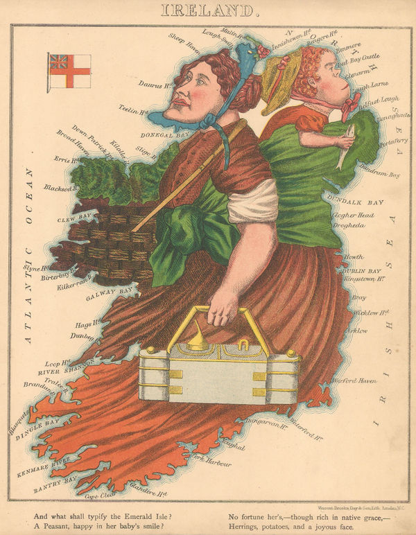
Robert Dighton, Rare caricature map of Ireland, 1797£ 4,000.00
-
John Cary, Ireland divided into provinces and counties, 1799£ 625.00
-
John Cary, Ireland, 1805£ 485.00
-
John Pass, A New and Correct Map of Ireland, 1808£ 225.00
-
Aaron Arrowsmith, Ireland, 1811£ 4,750.00
-
John Thomson, Ireland on two sheets joined, 1817£ 750.00
-
John Arrowsmith, Ireland, 1842£ 345.00
-
Isaac Slater, Ireland with railways and canals, 1845£ 825.00
-
Samuel Augustus Mitchell, Ireland, 1849£ 245.00
-
Samuel Lewis, Map of Ireland, 1850£ 475.00
-
John Tallis, Ireland, 1851£ 445.00
-
Aleph, Scarce caricature map of Ireland, 1869£ 1,950.00
-
Edward Stanford, Geological Map of Ireland, 1878£ 1,200.00
-
Society for the Diffusion of Useful Knowledge (SDUK), Ireland, 1879£ 235.00
-
Letts & Son, Ireland, 1881£ 185.00
-
Henry Cuthbert Tunison, Ireland, 1885 (c.)£ 95.00
-
Arbuckle Brothers Company, Ireland, 1889£ 175.00
-
George W. Bacon, Ireland, 1898£ 75.00
-
Edward Stanford, Geological Map of Ireland, 1912£ 55.00
All Maps
Our entire inventory of over 10,000 antique and vintage maps is now available to browse by region, date, cartographer, and subject