-
 Jan Blaeu, Regiones Svb Polo Arctico, 1650 c.£ 950.00
 -
Frederick De Wit, Terra Australis Incognita, 1680 c.£ 1,250.00
-
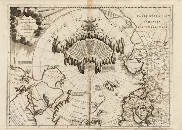
Vincenzo Coronelli, Terre Artiche, 1695 c.£ 2,950.00
-
Heinrich Scherer, Regionvm Circvm Polarivm, 1701£ 950.00
-
This Draught of the North Pole is to shew all the Countries near and adjacent to it, 1705Herman MollSeries: LondonHerman Moll, This Draught of the North Pole is to shew all the Countries near and adjacent to it, 1705£ 1,450.00
-
Hemisphere Septentrional - Les Terres Arctiques, 1733Covens (Jean) & Mortier (Cornelius)Series: AmsterdamCovens (Jean) & Mortier (Cornelius), Hemisphere Septentrional - Les Terres Arctiques, 1733£ 650.00
-
Henri du Sauzet, Terres Antarctiques, 1734£ 675.00
-
Herman Moll, A Map of the North Pole, 1750 c.£ 650.00
-
Antonio Zatta, Emisfero Terrestre Meridionale | Emisfero Terrestre Septentrionale, 1779£ 645.00
-
Carte de L'Hemisphere Austral Montrant les Routes des Navigateurs les plus Célebres Par le Captaine Jacques Cook, 1790 c.Capt. James CookSeries: ParisCapt. James Cook, Carte de L'Hemisphere Austral Montrant les Routes des Navigateurs les plus Célebres Par le Captaine Jacques Cook, 1790 c.£ 2,500.00
-
Capt. James Cook, Van Kerguelens Land, 1794£ 145.00
-
John Wilkes, Countries Surrounding the North Pole, 1807£ 225.00
-
Chart of Part of the North Eastern Coast of America, and its adjacent Islands, 1824Sir William Edward ParrySeries: LondonSir William Edward Parry, Chart of Part of the North Eastern Coast of America, and its adjacent Islands, 1824£ 545.00
-
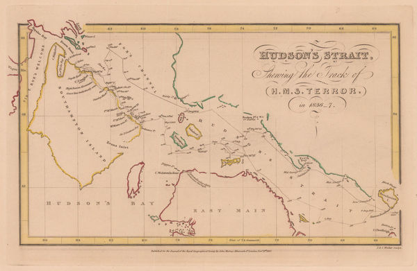
Royal Geographical Society (RGS), Hudson's Strait, 1837£ 95.00
-
Benedetto Marzolla, Carta Generale dell'Antartica, 1842£ 1,450.00
-
Royal Geographical Society (RGS), Frobisher Strait & Northumberland Inlet, 1842£ 145.00
-
Perspective Projection of the Southern Hemisphere on the Plane of the Horizon of London, 1845 c.Joseph Wilson LowrySeries: LondonJoseph Wilson Lowry, Perspective Projection of the Southern Hemisphere on the Plane of the Horizon of London, 1845 c.£ 745.00
-
British Admiralty, Chart of the North Polar Sea, 1849£ 950.00
-
James Wyld, Chart of the Arctic Regions from the Admiralty Surveys, 1851 c.£ 2,950.00
-
Chart of the Northern portion of Baffin Bay to illustrate Col. Inglefields report., 1853Royal Geographical Society (RGS)Series: LondonRoyal Geographical Society (RGS), Chart of the Northern portion of Baffin Bay to illustrate Col. Inglefields report., 1853£ 145.00
-
Joseph Meyer, Neueste Karte vom Sud-Pol, 1853£ 595.00
-
Sketch of the Shores of Arctic America to illustrate the Discovery of the Northwest Passage, 1855Royal Geographical Society (RGS)Series: LondonRoyal Geographical Society (RGS), Sketch of the Shores of Arctic America to illustrate the Discovery of the Northwest Passage, 1855£ 375.00
-
Joseph Hutchins Colton, Southern Regions, 1855£ 450.00
-
A. & C. Black, Arctic Regions and British America, 1856£ 325.00
-
The Route of Sir John Franklin's Doomed Arctic Expedition, 1856Royal Geographical Society (RGS)Series: LondonRoyal Geographical Society (RGS), The Route of Sir John Franklin's Doomed Arctic Expedition, 1856£ 595.00
-
Royal Geographical Society (RGS), Discoveries of the American Expedition, 1856£ 295.00
-
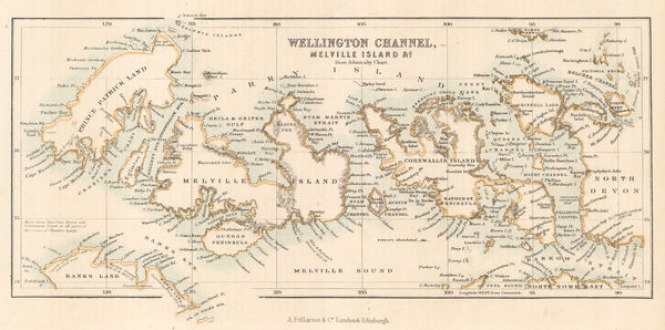
Archibald Fullarton, Wellington Channel, Melville Island &c., 1856£ 82.00
-
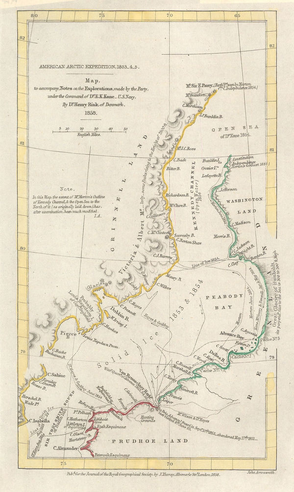
Royal Geographical Society (RGS), American Arctic Expedition, 1853_4_5, 1858£ 185.00
-
Übersichtskarte der wahrscheinlichen Route von Sir J. Franklin's Expedition, 1859Justus PerthesSeries: GothaJustus Perthes, Übersichtskarte der wahrscheinlichen Route von Sir J. Franklin's Expedition, 1859£ 95.00
-
Royal Geographical Society (RGS), Map of the North Polar Regions, 1865£ 185.00
-
Justus Perthes, Die Meeres-Temperatur des Grönländischen Meeres, 1869£ 88.00
-
Royal Geographical Society (RGS), The South-Polar Regions, 1869£ 950.00
-
Royal Geographical Society (RGS), King William Land, 1880£ 115.00
-
Royal Geographical Society (RGS), Map of the Barents & Kara Seas, 1880£ 195.00
-
Chart Showing Mr. Leigh Smith's Track to Franz Josef Land and Boat Journey to Novaya Zemlya in 1881-1882, 1883Royal Geographical Society (RGS)Series: LondonRoyal Geographical Society (RGS), Chart Showing Mr. Leigh Smith's Track to Franz Josef Land and Boat Journey to Novaya Zemlya in 1881-1882, 1883£ 75.00
-
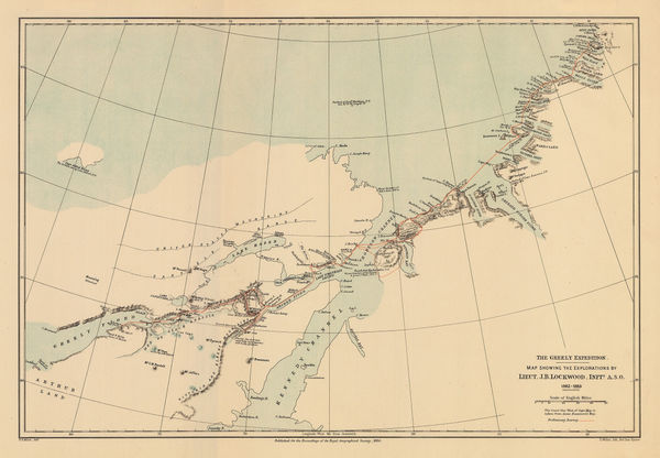
Royal Geographical Society (RGS), The Greely Expedition, 1884£ 320.00
-
The Geographical Discoveries of Lieut. Greely's Expedition, 1882-3., 1885Scottish Geographical Society (SGS)Series: EdinburghScottish Geographical Society (SGS), The Geographical Discoveries of Lieut. Greely's Expedition, 1882-3., 1885£ 225.00
-
South Polar Chart showing Heights of Land and Depths of Sea, 1886Scottish Geographical Society (SGS)Series: EdinburghScottish Geographical Society (SGS), South Polar Chart showing Heights of Land and Depths of Sea, 1886£ 1,600.00
-
J.G. Bartholomew, North Polar Regions, 1887£ 66.00
-
Augustus Petermann, Sud-Polar Karte, 1889£ 950.00
-
Justus Perthes, Die Arktische Windscheide und die Neuesten Polarprojekte, 1891£ 92.00
-
Sketch Map of Arctic Regions Showing Dr. Nansen's Projected Route, 1892Scottish Geographical Society (SGS)Series: EdinburghScottish Geographical Society (SGS), Sketch Map of Arctic Regions Showing Dr. Nansen's Projected Route, 1892£ 225.00
-
Map Illustrating Mr H. O. Forbes' paper on The Chatham Islands., 1893Royal Geographical Society (RGS)Series: LondonRoyal Geographical Society (RGS), Map Illustrating Mr H. O. Forbes' paper on The Chatham Islands., 1893£ 445.00
-
Map Shewing Route of the North Greenland Expedition of 1891-92, 1893Royal Geographical Society (RGS)Series: LondonRoyal Geographical Society (RGS), Map Shewing Route of the North Greenland Expedition of 1891-92, 1893£ 125.00
-
Scottish Geographical Society (SGS), Sketch Map of South Polar Regions, 1894£ 450.00
-
Sketch-Chart on Mercator's Projection, Showing Track of the 'Jason', 1893-94, 1894Scottish Geographical Society (SGS)Series: EdinburghScottish Geographical Society (SGS), Sketch-Chart on Mercator's Projection, Showing Track of the 'Jason', 1893-94, 1894£ 950.00
-
Edward Stanford, Map of the Countries Around the North Pole, 1896£ 895.00
-
Scottish Geographical Society (SGS), Chart of North Polar Regions, 1897£ 595.00
-
John Bartholomew, Physical Chart of the North Polar Regions, 1897£ 895.00
-
Royal Geographical Society (RGS), Antarctic Regions, 1898£ 2,600.00
-
Royal Geographical Society (RGS), Sketch map of Franz Joseph Land, 1898£ 195.00
-
Scottish Geographical Society (SGS), Chart of the South Polar Regions, 1900£ 725.00
-
Map of Part of the Coastline of South Victoria Land, 1900Royal Geographical Society (RGS)Series: LondonRoyal Geographical Society (RGS), Map of Part of the Coastline of South Victoria Land, 1900£ 2,650.00
-
John Bartholomew & Co., North Polar Regions, 1900 (c.)£ 95.00
-
Sketch of Danco Land the Belgica Strait and Palmer Archipelago, 1901Royal Geographical Society (RGS)Series: LondonRoyal Geographical Society (RGS), Sketch of Danco Land the Belgica Strait and Palmer Archipelago, 1901£ 850.00
-
Map Showing Discoveries of Commander Peary's Expedition, 1900-2, 1903Scottish Geographical Society (SGS)Series: EdinburghScottish Geographical Society (SGS), Map Showing Discoveries of Commander Peary's Expedition, 1900-2, 1903£ 285.00
-
Sketch Map to Illustrate the North Polar Explorations, 1903Royal Geographical Society (RGS)Series: LondonRoyal Geographical Society (RGS), Sketch Map to Illustrate the North Polar Explorations, 1903£ 225.00
-
British Admiralty, Wilkes Land, Adelie Land & George V Land, 1904£ 2,500.00
-
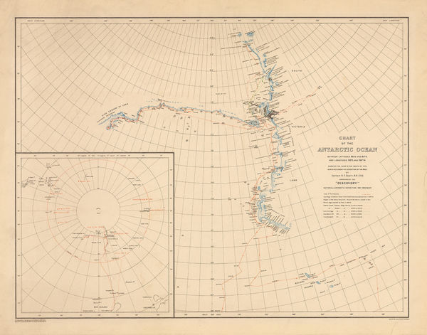
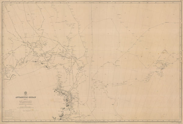
George F. A. Mulock, Chart of the Antarctic Ocean, 1904£ 1,750.00
-
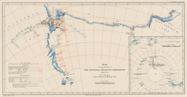
Map Showing the Work of The National Antarctic Expedition 1902-03-04, 1904Royal Geographical Society (RGS)Series: LondonRoyal Geographical Society (RGS), Map Showing the Work of The National Antarctic Expedition 1902-03-04, 1904£ 2,950.00
-
Royal Geographical Society (RGS), Map Showing Track of the S.Y. 'Morning', 1904£ 600.00
-
Scottish Geographical Society (SGS), Scottish National Antarctic Expedition, 1904£ 1,800.00
-
Sketch Maps Showing the Track & Expeditions of the German South Polar Expedition 1902-3, 1904Royal Geographical Society (RGS)Series: LondonRoyal Geographical Society (RGS), Sketch Maps Showing the Track & Expeditions of the German South Polar Expedition 1902-3, 1904£ 750.00
-
George F. A. Mulock, Scott's Map of the Ross Barrier Ice Shelf, 1904£ 2,750.00
-
Bathymetrical Survey of the South Atlantic Ocean and Weddell Sea, 1905Scottish Geographical Society (SGS)Series: EdinburghScottish Geographical Society (SGS), Bathymetrical Survey of the South Atlantic Ocean and Weddell Sea, 1905£ 1,250.00
-
George F. A. Mulock, Robert Falcon Scott's Discovery Expedition, 1905£ 2,850.00
-
Deep Sea Deposits of the South Atlantic Ocean and Weddell Sea, 1905Scottish Geographical Society (SGS)Series: EdinburghScottish Geographical Society (SGS), Deep Sea Deposits of the South Atlantic Ocean and Weddell Sea, 1905£ 950.00
-
Scottish National Antarctic Expedition - Map showing the track of the "Scotia", 1903-1904, 1905Scottish Geographical Society (SGS)Series: EdinburghScottish Geographical Society (SGS), Scottish National Antarctic Expedition - Map showing the track of the "Scotia", 1903-1904, 1905£ 1,800.00
-
Sketch map to Illustrate the paper by Dr. Charcot on the French Antarctic Expedition, 1905Royal Geographical Society (RGS)Series: LondonRoyal Geographical Society (RGS), Sketch map to Illustrate the paper by Dr. Charcot on the French Antarctic Expedition, 1905£ 950.00
-
George F. A. Mulock, Sledge Journeys from Winter Quarters, 1905£ 2,850.00
-
Bathymetrical Chart of North Polar Seas by Dr.Fridtjof Nansen, 1907Royal Geographical Society (RGS)Series: LondonRoyal Geographical Society (RGS), Bathymetrical Chart of North Polar Seas by Dr.Fridtjof Nansen, 1907£ 185.00
-
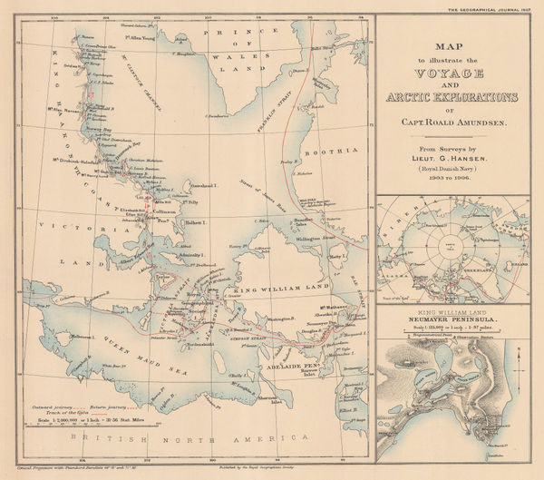
Roald Amundsen's Gjøa Expedition through the Northwest Passage, 1907Royal Geographical Society (RGS)Series: LondonRoyal Geographical Society (RGS), Roald Amundsen's Gjøa Expedition through the Northwest Passage, 1907£ 395.00
-
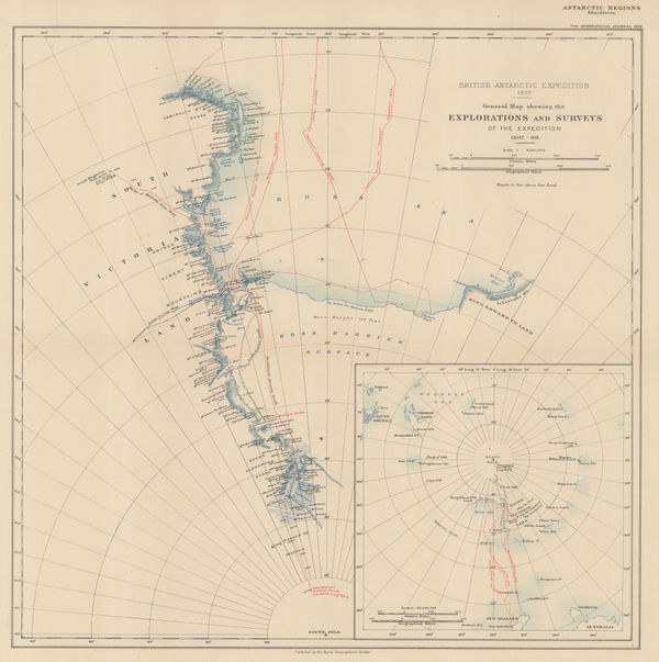
British Antarctic Expedition 1907. Route and Surveys of the South Magnetic Polar Party, 1909William HeinemannSeries: LondonWilliam Heinemann, British Antarctic Expedition 1907. Route and Surveys of the South Magnetic Polar Party, 1909£ 3,000.00
-
Royal Geographical Society (RGS), Shackleton's British Antarctic Expedition, 1909£ 2,200.00
-
Routes and Surveys of the South Magnetic Polar Party, 1909Royal Geographical Society (RGS)Series: LondonRoyal Geographical Society (RGS), Routes and Surveys of the South Magnetic Polar Party, 1909£ 1,650.00
-
British Antarctic Expedition 1907, Routes and Surveys of the Southern Journey Party 1908- 09, 1909 c.William HeinemannSeries: LondonWilliam Heinemann, British Antarctic Expedition 1907, Routes and Surveys of the Southern Journey Party 1908- 09, 1909 c.£ 3,500.00
-
British Admiralty, Antarctic Ocean Sheet IV, 1910£ 3,500.00
-
Royal Geographical Society (RGS), Peary's North Pole Expedition (1908-1909), 1910£ 325.00
-
Maps to Illustrate the Paper by Dr. J.B. Charcot on the French Antarctic Expedition 1908-1910, 1911Royal Geographical Society (RGS)Series: LondonRoyal Geographical Society (RGS), Maps to Illustrate the Paper by Dr. J.B. Charcot on the French Antarctic Expedition 1908-1910, 1911£ 750.00
-
Royal Geographical Society (RGS), South Polar Regions, 1911£ 1,850.00


Page
1
of 2