-
 Thomas Kelly, Plan of the Battle of Waterloo, 1816£ 850.00
 -
John Thomson, Grenada, 1816 c.£ 195.00
-
John Thomson, Island of Cuba, 1816 c.£ 345.00
-
John Thomson, Abyssinia, 1817£ 145.00
-
Rigobert Bonne, Australia and the South Pacific Ocean, 1817£ 380.00
-
Friedrich Wilhelm Streit, Australia and the South Pacific, 1817£ 1,250.00
-
Langley & Belch, England and Wales, 1817£ 445.00
-
John Cary, Hertfordshire, 1817£ 62.00
-
Langley & Belch, Langley's New Map of Berkshire, 1817£ 125.00
-
Langley & Belch, Langley's New Map of Cambridgeshire, 1817£ 88.00
-
Langley & Belch, Langley's New Map of Cheshire, 1817£ 115.00
-
Langley & Belch, Langley's New Map of Cumberland, 1817£ 98.00
-
Langley & Belch, Langley's New Map of Derbyshire, 1817£ 80.00
-
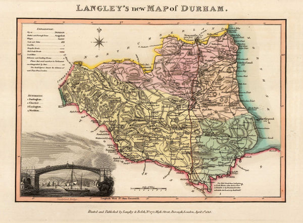
Langley & Belch, Langley's New Map of Durham, 1817£ 82.00
-
Langley & Belch, Langley's New Map of Essex, 1817£ 145.00
-
Langley & Belch, Langley's New Map of Herefordshire, 1817£ 72.00
-
Langley & Belch, Langley's New Map of Huntingdonshire, 1817£ 85.00
-
Langley & Belch, Langley's New Map of Lincolnshire, 1817£ 92.00
-
Langley & Belch, Langley's New Map of Northamptonshire, 1817£ 85.00
-
Langley & Belch, Langley's New Map of Northumberland, 1817£ 95.00
-
Langley & Belch, Langley's New Map of Oxfordshire, 1817£ 165.00
-
Langley & Belch, Langley's New Map of Rutlandshire, 1817£ 58.00
-
Langley & Belch, Langley's New Map of Staffordshire, 1817£ 115.00
-
Langley & Belch, Langley's New Map of Surrey, 1817£ 175.00
-
Langley & Belch, Langley's New Map of Warkwickshire, 1817£ 98.00
-
Sidney Hall, Central Asia, 1817£ 295.00
-
John Thomson, Islands in the Pacific Ocean, 1817£ 445.00
-
Christoph Melchior Fembo, Scandinavia, 1817£ 295.00
-
John Thomson, Ireland on two sheets joined, 1817£ 750.00
-
John Thomson, Eastern United States, 1817£ 1,250.00
-
Thomas Kelly, The Armillary Sphere, 1817£ 125.00
-
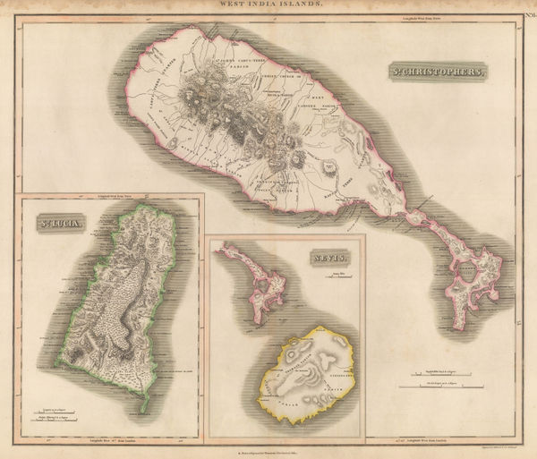
John Thomson, St. Lucia, St. Kitts, and Nevis, 1817£ 395.00
-
Laurie & Whittle, New Map of London with its Environs, 1817£ 1,950.00
-
John Thomson, Northern India, Nepal & Afghanistan, 1817£ 495.00
-
John Thomson, Northern Provinces of the United States, 1817£ 1,350.00
-
William Plees, Jersey, 1817£ 650.00
-
John Thomson, France, 1817 c.£ 115.00
-
Langley & Belch, New Map of Surrey, 1817 c.£ 155.00
-
J. Freeman & Samuel Dana, A Geological Map of Boston and its Vicinity, 1818£ 1,450.00
-
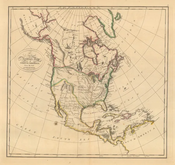
Matthew Carey, North America, 1818£ 625.00
-
Matthew Carey, South America, 1818£ 450.00
-
William Faden, A New Topographical Map of the Country in the Vicinity of London, 1818£ 2,650.00
-
Felix Delamarche, Carte Generale De L'Amerique, 1818£ 675.00
-
Jean Francois de La Perouse, Pacific Ocean and Australasia, 1818£ 725.00
-
-
Christian Gottlieb Reichard, North-western Africa, 1818£ 75.00
-
Matthew Carey, Delaware from the best Authorities, 1818£ 1,150.00
-
Bartolomeo Borghi, China, Japan, Tibet, and Mongolia, 1818£ 285.00
-
Langley & Belch, Langley's New Map of Brecknockshire, 1818£ 75.00
-
Langley & Belch, Langley's New Map of Carnarvonshire, 1818£ 75.00
-
Langley & Belch, Langley's New Map of Denbighshire, 1818£ 65.00
-
Langley & Belch, Langley's New Map of Merionethshire, 1818£ 65.00
-
Langley & Belch, Langley's New Map of Montgomeryshire, 1818£ 80.00
-
Longman & Co., London and its Environs, 1818£ 825.00
-
Matthew Carey, Louisiana, 1818£ 1,450.00
-
Map of Maj. Gen. Ross's route, with the British Column, from Benedict, on the Patuxent River, to the City of Washington, August 1814, 1818William JamesSeries: Washington, D.C.William James, Map of Maj. Gen. Ross's route, with the British Column, from Benedict, on the Patuxent River, to the City of Washington, August 1814, 1818£ 885.00
-
Matthew Carey, Peru, 1818£ 145.00
-
Matthew Carey, Spain and Portugal, 1818£ 95.00
-
Matthew Carey, Switzerland, 1818£ 175.00
-
Matthew Carey, The State of Georgia, 1818£ 1,650.00
-
Matthew Carey, The State of Massachusetts, 1818£ 1,850.00
-
Matthew Carey, The State of Mississippi and Alabama Territory, 1818£ 1,250.00
-
The State of New Jersey Compiled from the most Authentic Information, 1818Matthew CareySeries: PhiladelphiaMatthew Carey, The State of New Jersey Compiled from the most Authentic Information, 1818£ 1,550.00
-
Matthew Carey, The State of Tennessee, 1818£ 1,450.00
-
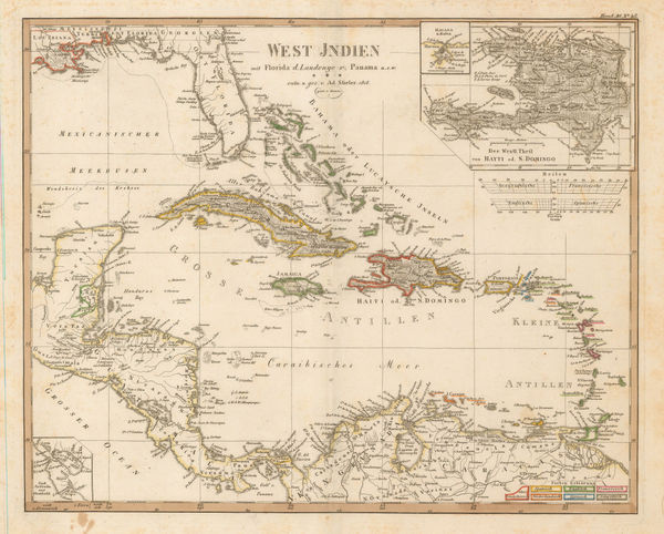
Adolf Stieler, The West Indies, 1818£ 295.00
-
Morris Birkbeck, Early map of Ohio, Indiana and the Territory of Illinois, 1818£ 1,250.00
-
-
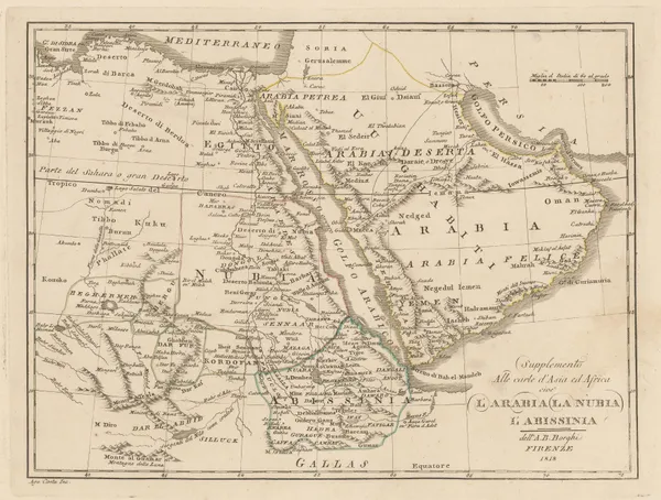
Bartolomeo Borghi, Arabia, Nubia, and Abyssinia, 1818£ 395.00
-
Sidney Hall, Northamptonshire, 1818£ 40.00
-
John William Norie, Chart of the White Sea, 1819£ 2,250.00
-
John Cary, A New Map of America, 1819£ 1,250.00
-
William Faden, Miniature map of Asia, 1819£ 135.00
-
Antoine-Ignace Melling, Bosphorus and Constantinople, 1819£ 1,450.00
-
William Faden, France Divided into Military Governments as in 1790, 1819£ 45.00
-
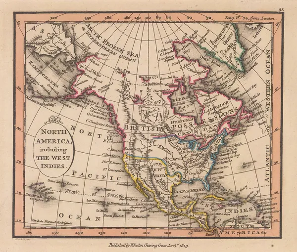
William Faden, North America including the West Indies, 1819£ 385.00
-
John Wilkes, Northamptonshire, 1819£ 85.00
-
John Wilkes, Northumberland, 1819£ 75.00
-
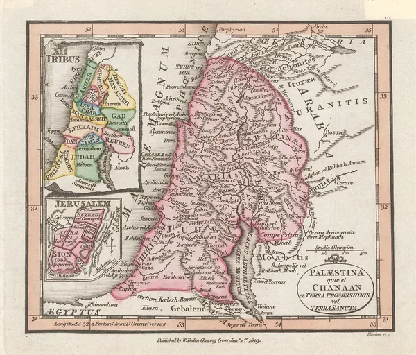
William Faden, Miniature atlas map of the Holy Land, 1819£ 195.00
-
Antoine-Ignace Melling, French plan of Istanbul (Constantinople), 1819£ 2,950.00
-
William Faden, Switzerland, 1819£ 98.00


Page
56
of 130