-
 Giovanni De Agostini, Veneto, 1941£ 425.00
 -
Giovanni De Agostini, Venezia Tridentina, 1941£ 325.00
-
Giovanni De Agostini, Lombardy, 1941£ 395.00
-
Giovanni De Agostini, Emilia Romagna, 1941£ 395.00
-
Giovanni De Agostini, Campania, 1941£ 425.00
-
Giovanni De Agostini, Abruzzo , 1941£ 395.00
-
Louis Larmat, Les Vins de Bordeaux - Loupiac - Sainte-Croix-du-Monte, 1941£ 625.00
-
Louis Larmat, Les Vins de Bordeaux - Médoc - Haut Médoc, 1941£ 595.00
-
André Deran, WWII - Vichy French Propaganda, 1941£ 2,500.00
-
Steimatzky's Publishing, Damascus, 1941£ 85.00
-
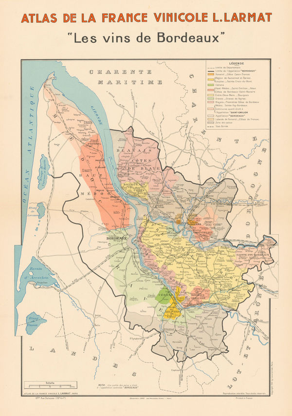
Louis Larmat, Bordeaux Wine Region, 1941£ 1,650.00
-
Miyahara Takeo, The Natural Resources of Thailand, 1941£ 750.00
-
Arthur B. Suchy, Cayo Hueso - Key West, Florida, 1941 c.£ 425.00
-
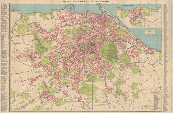
John Bartholomew, Pocket Plan of Edinburgh and Suburbs, 1941 c.£ 385.00
-
Luftwaffe, WW2-era map of Minsk, 1941 c.£ 595.00
-
S.P.K., WWII, 1941 c.£ 850.00
-
WWII commemorative map of northern Ethiopia, 1942East African Survey Group, British ArmySeries: East AfricaEast African Survey Group, British Army, WWII commemorative map of northern Ethiopia, 1942£ 495.00
-
Richard Edes Harrison, Atlantic Arena, 1942£ 350.00
-
British Admiralty, Cape San Blas to Vermilion Bay, 1942£ 750.00
-
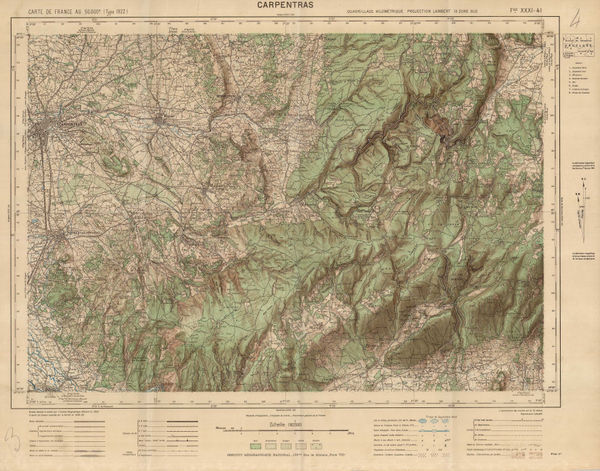
Institut géographique national (IGN), Carpentras, Provence, 1942£ 75.00
-
-
S.P.K., Vichy French Churchill Octopus Map, 1942£ 2,500.00
-
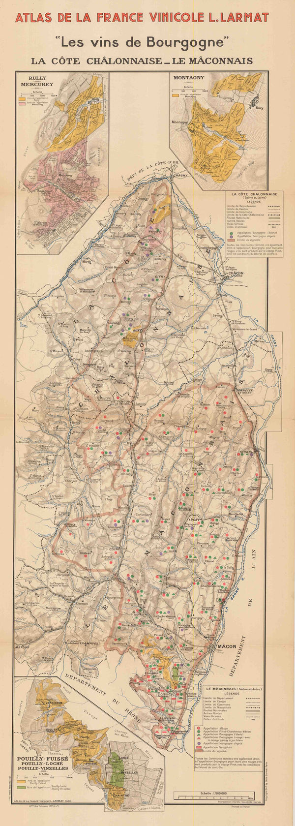
Louis Larmat, Wine map of Chalon and Macon, Burgundy, 1942£ 445.00
-
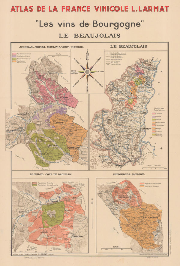
Larmat, Vineyards of Burgundy, 1942£ 645.00
-
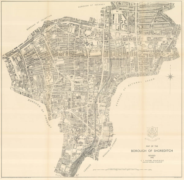
Ordnance Survey, The Borough of Shoreditch, 1942£ 625.00
-
British Admiralty, North America East Coast - Delaware Bay to Florida Strait, 1942£ 950.00
-
Richard Edes Harrison, One World One War, 1942£ 1,800.00
-
Plans on the Northeast Coast of Bahrein Island, 1942United States Hydrographic OfficeSeries: Washington, D.C.United States Hydrographic Office, Plans on the Northeast Coast of Bahrein Island, 1942£ 3,950.00
-
Rand, McNally & Co., Rand McNally Indexed Terrestrial Art Globe, 1942£ 350.00
-
Survey of India, Road Map of India, 1942£ 375.00
-
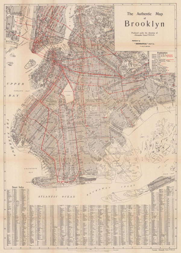
Geographia Map Co., The Authentic Map of Brooklyn, 1942£ 1,350.00
-
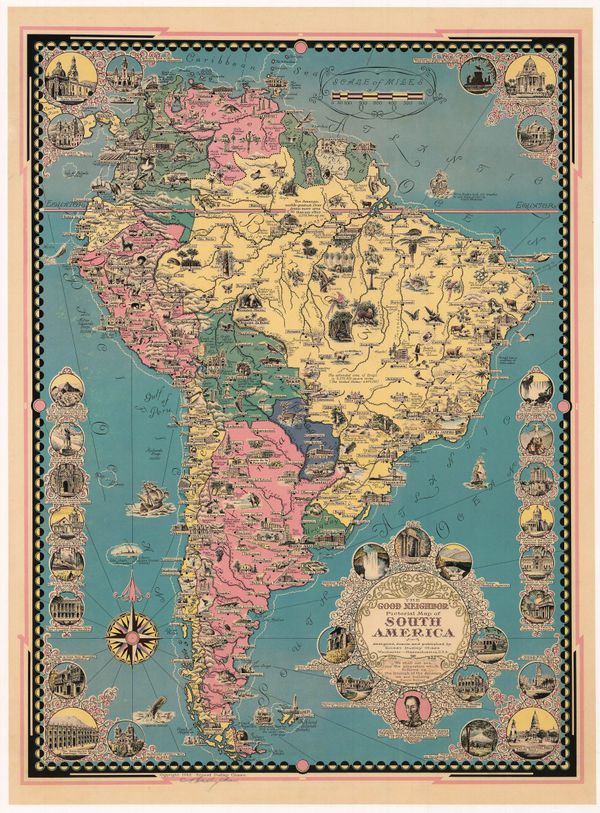
Ernest Dudley Chase, The Good Neighbor Pictorial Map of South America, 1942£ 750.00
-
-
Wings Over the World... Yesterday, Today and Tomorrow - Aviation Cavalcade, 1942F.E. CheesemanSeries: MilwaukeeF.E. Cheeseman, Wings Over the World... Yesterday, Today and Tomorrow - Aviation Cavalcade, 1942£ 750.00
-
Geographical Section, General Staff (GSGS), WW2 Map of the East Indies, 1942£ 450.00
-
Louis Larmat, Burgundy Wine Map - La Côte de Nuits, 1942£ 1,500.00
-
Louis Larmat, "Les vins de Bourgogne" - La Côte de Beaune, 1942£ 1,650.00
-
Louis Larmat, Les Vins de Bourgogne - Chablis Grand Cru - Chablis, 1942£ 795.00
-
Ordnance Survey, Bodmin - O.S.Sheet 136, 1942£ 125.00
-
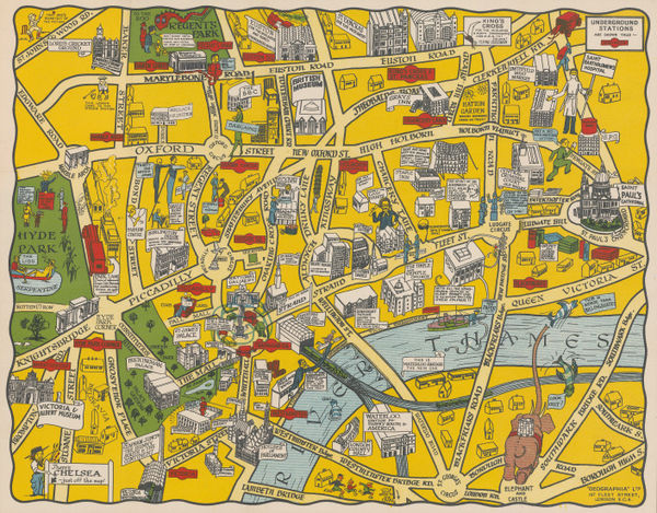
George Philip & Son Ltd., The New Pictorial Map of London, 1942 c£ 295.00
-
Anonymous, German Propaganda map attacking the Atlantic Charter, 1942 c.£ 4,500.00
-
Charles R. Southwell, New Map of Greater San Antonio, 1942 c.£ 950.00
-
Louis Larmat, Wine map of Tavel and Châteauneuf-du-Pape, Côtes du Rhône, 1943£ 550.00
-
War Office, Brixham Harbour, 1943£ 28.00
-
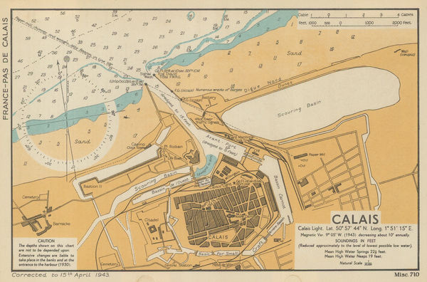
War Office, Calais, 1943£ 32.00
-
Survey of India, Kolkata (Calcutta) and Howrah, 1943£ 785.00
-
War Office, Dover, 1943£ 48.00
-
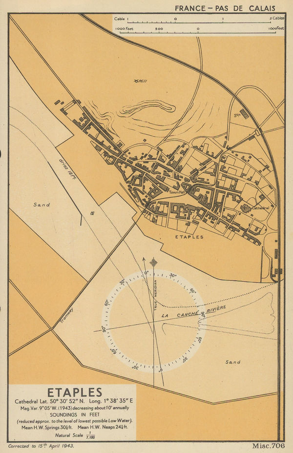
War Office, Etaples, 1943£ 32.00
-
Aluminum Company of America (ALCOA), Global Map for Global War and Global Peace, 1943£ 650.00
-
Geographical Section, General Staff (GSGS), Folding map of West Africa, 1943£ 375.00
-
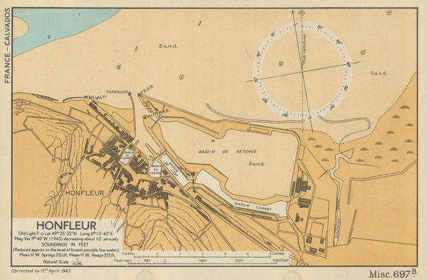
War Office, Honfleur, 1943£ 76.00
-
War Office, Hythe, 1943£ 36.00
-
War Office, Mouth of the River Canche, Pas-de-Calais, 1943£ 22.00
-
Louis Larmat, Wine map of Cotes de Blaye and Cotes de Bourg, Bordeaux, 1943£ 325.00
-
Louis Larmat, Wine map of Entre-Deux-Mers, Grave de Vayres- Sainte-Foy-Bordeaux, 1943£ 425.00
-
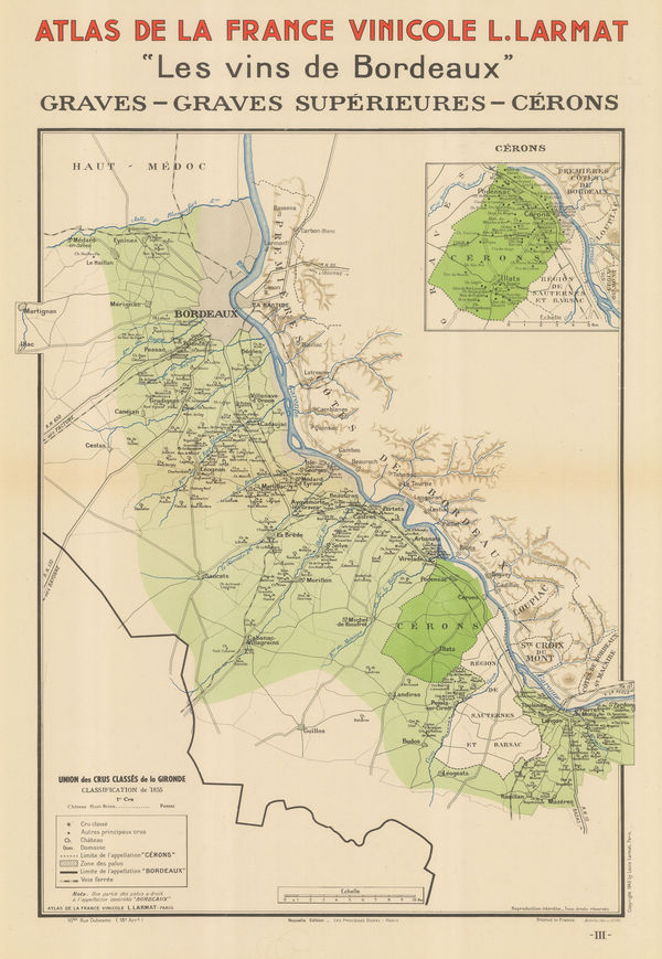
Louis Larmat, Wine map of Graves, Graves Superieures, and Cerons, Bordeaux, 1943£ 365.00
-
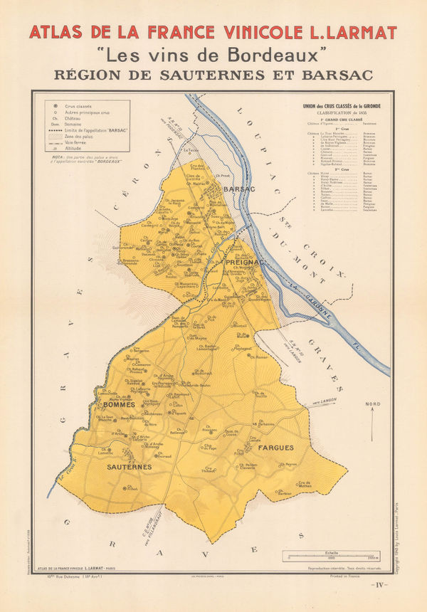
Louis Larmat, Wine map of Sauternes, Barsac, Preignac, and Bommes, Bordeaux, 1943£ 325.00
-
Louis Larmat, Wine map of Châteauneuf-du-Pape and Tavel, Côtes du Rhône, 1943£ 545.00
-
War Office, Looe, 1943£ 45.00
-
T.S. Duraiswami Ayyar, Map of the Madras Presidency, 1943£ 495.00
-
War Office, River Seine: Le Havre to Rouen, 1943£ 36.00
-
War Office, Sheerness, 1943£ 34.00
-
Souvenir Map and Guide to Starland Estates and Mansions... A Fascinating Trip Through Movieland, 1943Wesley G. LakeSeries: Los AngelesWesley G. Lake, Souvenir Map and Guide to Starland Estates and Mansions... A Fascinating Trip Through Movieland, 1943£ 1,350.00
-
War Office, St. Ives / Hayle, 1943£ 55.00
-
Geographical Section, General Staff (GSGS), Tanganyika (Tanzania), 1943£ 445.00
-
The Seamen's Bank for Savings: Rapid Transit map of Greater New York, 1943General Drafting Co.Series: New YorkGeneral Drafting Co., The Seamen's Bank for Savings: Rapid Transit map of Greater New York, 1943£ 325.00
-
War Office, Tilbury and Gravesend, 1943£ 38.00
-
War Office, Le Tréport, Normandy, 1943£ 32.00
-
Geographical Section, General Staff (GSGS), Trinidad, 1943£ 285.00
-
War Office, Trouville, 1943£ 72.00
-
Edward Stanford, Library and Commercial Map of Europe, 1943£ 650.00
-
War Office, Mecca & Jeddah, 1943£ 950.00
-
Jean Dratz, Bordeaux et ses Vins, 1943£ 850.00
-
Monaco Tourism Office, Principality of Monaco, 1943£ 1,450.00
-
Dade County Newsdealer's Supply Co., Miami & Miami Beach, 1943£ 375.00
-
J. Foster Ashburn, Ashburn's Fort Worth, Tex, 1943 c£ 295.00
-
Anonymous, Portuguese WW2 Propaganda, 1943 c.£ 650.00
-
Royal Geographical Society (RGS), Britain's Areas of Natural Beauty, 1944£ 78.00
-
Richard Schwarz, World War II German map of Europe, 1944£ 750.00
-
Spanish War Office, Ibiza, 1944£ 845.00


Page
121
of 131