-
 A. Simon, Mostaganem. (1886), 1886£ 62.00
 -
Justus Perthes, Sketch map of Faiyum and the Pyramids of Giza, 1887£ 68.00
-
A. Simon, Tunis et ses Abords, 1888£ 175.00
-
Royal Geographical Society (RGS), Northwest Morocco showing desert tribes, 1889£ 95.00
-
Royal Geographical Society (RGS), Map of South Western Morocco, 1889£ 45.00
-
Gaston Chaumelin, Folding wall map of the Suez Canal, 1889£ 1,850.00
-
Arbuckle Brothers Company, Morocco, 1889£ 115.00
-
-
Arbuckle Brothers Company, Egypt, 1889£ 98.00
-
J. Migeon, Algeria, 1890 c.£ 48.00
-
Letts & Son, Algeria, 1892£ 52.00
-
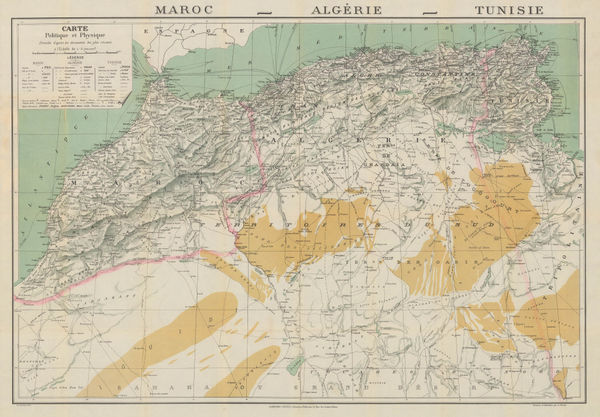
Sketch Maps Illustrating the Physical and Political Geography of Algeria, 1894Scottish Geographical Society (SGS)Series: EdinburghScottish Geographical Society (SGS), Sketch Maps Illustrating the Physical and Political Geography of Algeria, 1894£ 58.00
-
A Map of parts of Gharian, Tarhuna, and M'Salata (Tripoli), 1897Royal Geographical Society (RGS)Series: LondonRoyal Geographical Society (RGS), A Map of parts of Gharian, Tarhuna, and M'Salata (Tripoli), 1897£ 345.00
-
Royal Geographical Society (RGS), Sketch Map of Southern Tunis, 1898£ 62.00
-
Garnier Frères, Morocco, Algeria & Tunisia, 1900 c.£ 195.00
-
Edward Stanford, Alexandria, 1901£ 62.00
-
Edward Stanford, Cairo, 1901£ 78.00
-
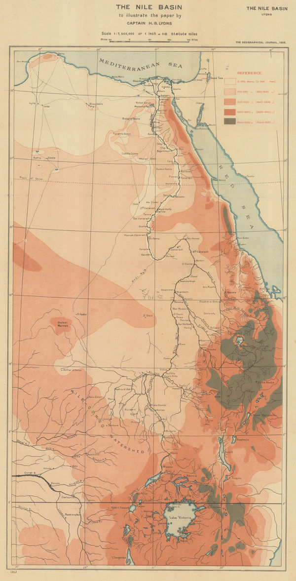
Royal Geographical Society (RGS), Orographical map of the Nile Basin, 1908£ 195.00
-
Edward Hertslet, Map Showing Turco-Egyptian Boundary, 1909£ 62.00
-
Edward Hertslet, Western Sahara and Mauritania border, 1909£ 48.00
-
Nestor Larras, French Army Map of Casablanca and Environs, 1910£ 395.00
-
Enciclopedia Segui, Cairo, 1910 (c.)£ 75.00
-
Karl Baedeker, Carthage, 1911£ 44.00
-
Karl Baedeker, Tourist plan of Tangier (Tanger), 1911£ 42.00
-
Karl Baedeker, Tunis, 1911£ 38.00
-
Karl Baedeker, Algiers, 1911£ 38.00
-
Karl Baedeker, Algeria, Tunisia & Libya, 1911£ 38.00
-
Edward Stanford, Cairo, 1918£ 75.00
-
Louis Gentil, Geological map of Morocco, 1920£ 945.00
-
Alexander Nicohosoff, A New Map of Cairo and Environs, 1920 c£ 345.00
-
Service Géographique de l'Armée, Relief map of Morocco, 1920 c.£ 250.00
-
Jules Chaure, Tourist Map of Casablanca, Morocco, 1920 c.£ 445.00
-
George W. Bacon, Cairo, 1921£ 650.00
-
Service Géographique de l'Armée, Southern Morocco, 1924£ 225.00
-
E. Toutey, Folding wall map of Morocco, 1925 c.£ 975.00
-
Cartes Tarides, Vintage folding map of Morocco, 1926 c.£ 545.00
-
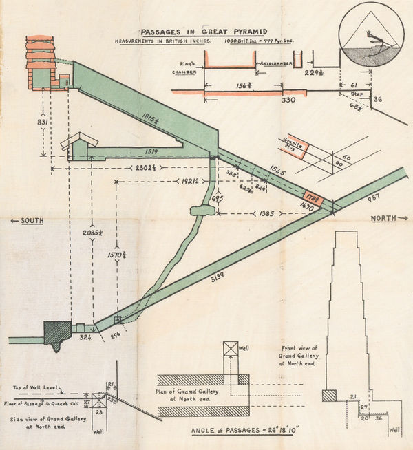
Anonymous, Passages in the Great Pyramid, 1927 c£ 150.00
-
Service Géographique de l'Armée, Folding vintage map of Morocco, 1930£ 375.00
-
Service Géographique de l'Armée, Vintage map of Marrakesh, 1930£ 475.00
-
Anonymous, Environs of Marrakesh, 1930 c£ 68.00
-
Cartes Tarides, Morocco based on French army surveys, 1930 c.£ 595.00
-
Editions France Afrique, Vintage folding plan of Marrakesh, 1930 c.£ 845.00
-
Alexander Nicohosoff, Tourist Map of Cairo, 1930 c.£ 145.00
-
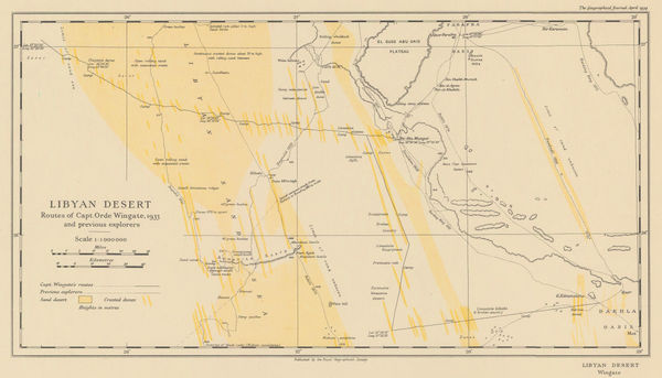
The Libyan Desert showing the Routes of Major R. A. Bagnold's Expeditions 1929 & 1930, 1931Royal Geographical Society (RGS)Series: LondonRoyal Geographical Society (RGS), The Libyan Desert showing the Routes of Major R. A. Bagnold's Expeditions 1929 & 1930, 1931£ 285.00
-
Service Géographique de l'Armée, Vintage map of Western Morocco, 1932£ 325.00
-
John Bartholomew, Tunis, 1933£ 55.00
-
Karl Baedeker, Miniature plan of Algiers, 1934£ 48.00
-
Royal Geographical Society (RGS), Orde Wingate's Egypt Expedition, 1934£ 175.00
-
Royal Geographical Society (RGS), Egypt, Libya, and Sudan Boundary Map, 1935£ 58.00
-
Egyptian Survey Department, Cairo, 1948£ 1,250.00
-
Lehnert and Landrock, Map of the Suez Canal, 1950 c.£ 145.00
-
Albino Caserta, Map of Cairo, 1953£ 695.00
-
Survey of Egypt, Arabic map of Cairo, 1954£ 475.00
-
Robert Genicot, Morocco, 1955£ 375.00
-
Jean Gaston Mantel, Vintage pictorial map of Morocco, 1958£ 575.00
-
Ibrahim Hilmi al-Ghouri, Palestine, Transjordan, Lebanon, Syria and Egypt, 1959 c£ 950.00
-
Anonymous, Marrakech, 1960 c.£ 345.00
-
Cairo Drawing Office, Egypt, 1965 c£ 275.00


Page
3
of 3