-
 Martin Waldseemüller & Laurent Fries, The Second Printed Map of Southern Africa, 1541£ 4,950.00
 -
Petrus Bertius, Africae pars meridional., 1616£ 495.00
-
Willem & Jan Blaeu, Southern & Central Africa, 1640 c.£ 1,250.00
-
Nicolas & Guillaume Sanson, Southern Africa, 1656£ 695.00
-
Athanasius Kircher, The Source of the Nile in the Mountains of the Moon, 1665£ 1,750.00
-
Robert Morden, Southern & Central Africa, 1688£ 375.00
-
Pierre Duval, Southern & Central Africa, 1694£ 295.00
-
Vincenzo Coronelli, Madagascar & East Africa (Globe Gore), 1696£ 895.00
-
Nicolas de Fer, Southern & Central Africa, 1702£ 795.00
-
Pierre Mortier, Map of the Coasts of Africa, 1708£ 1,750.00
-
Pierre Mortier, Comoro Islands and the Mozambique coast, 1708£ 795.00
-
Covens (Jean) & Mortier (Cornelius), Southern & Central Africa, 1730 c.£ 1,250.00
-
Nicolas Sanson, Southern Africa and Madagascar, 1741£ 875.00
-
Jacob van der Schley, South Eastern Coast of Africa, 1747£ 175.00
-
Emanuel Bowen, A New & Accurate Map of the Southern Parts of Africa, 1747£ 695.00
-
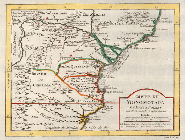
Jacques-Nicolas Bellin, Empire of Monomotapa (Mozambique), 1748£ 175.00
-
Jacques-Nicolas Bellin, Bay and Island of Mozambique, 1764£ 125.00
-
Tobias Conrad Lotter, Southern Africa & the Cape of Good Hope, 1778£ 745.00
-
Rigobert Bonne, Southern Africa, 1790 c.£ 150.00
-
Laurie & Whittle, A New Chart of the Southern Coast of Africa, 1794£ 3,250.00
-
Charles Francois Delamarche, Southern & Central Africa, 1795£ 325.00
-
British Admiralty, Sea Chart of the coast of Mozambique, 1828£ 145.00
-
British Admiralty, Sea Chart of the coast of Mozambique, 1828£ 225.00
-
Adrien Brue, Southern Africa & the Cape Colony, 1828 c.£ 250.00
-
Royal Geographical Society (RGS), Outline Map of Southern Africa, 1833£ 82.00
-
John Arrowsmith, Cape of Good Hope, 1842£ 850.00
-
Africa between 10 and 30 degree South Latitude. Map to illustrate the routes of Galton. Livingstone, Oswell and Gassiot, 1852Royal Geographical Society (RGS)Series: LondonRoyal Geographical Society (RGS), Africa between 10 and 30 degree South Latitude. Map to illustrate the routes of Galton. Livingstone, Oswell and Gassiot, 1852£ 495.00
-
Royal Geographical Society (RGS), Southern Central Africa, 1856£ 225.00
-
Royal Geographical Society (RGS), Portuguese Exploration in Central Africa, 1859£ 385.00
-
Royal Geographical Society (RGS), The Discovery of Lake Malawi (Nyasa), 1863£ 175.00
-
A Sketch map of Part of South Eastern Africa to Illustrate the Journeys of Dr Lacerda (1798) the Pombeiros (1806-11) and Major Monteiro (1831-32), 1873Royal Geographical Society (RGS)Series: LondonRoyal Geographical Society (RGS), A Sketch map of Part of South Eastern Africa to Illustrate the Journeys of Dr Lacerda (1798) the Pombeiros (1806-11) and Major Monteiro (1831-32), 1873£ 395.00
-
Royal Geographical Society (RGS), Route Map of the Gasa Country, 1875£ 175.00
-
Royal Geographical Society (RGS), Map of the Mozambique Coast, 1882£ 195.00
-
Royal Geographical Society (RGS), The Interior of South Africa, 1884£ 795.00
-
Justus Perthes, Geological map of Southeast Africa, 1884£ 295.00
-
Royal Geographical Society (RGS), Large scale map of Mozambique, 1885£ 495.00
-
Justus Perthes, Geological Map of South Africa, 1888£ 95.00
-
Eastern Africa between the Rovuma and Zambesi Rivers, 1890Royal Geographical Society (RGS)Series: LondonRoyal Geographical Society (RGS), Eastern Africa between the Rovuma and Zambesi Rivers, 1890£ 495.00
-
George W. Bacon, Bacon's Large-Print Map of South Africa, 1890 c.£ 775.00
-
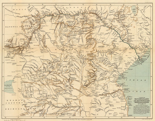
A Map of Matabililand and Mashonaland Manica and Gazaland, 1891Royal Geographical Society (RGS)Series: LondonRoyal Geographical Society (RGS), A Map of Matabililand and Mashonaland Manica and Gazaland, 1891£ 395.00
-
Map of Gaza Land showing route taken by Mr.D. Doyle from Manica to the Mouth of the Limpopo, 1891Royal Geographical Society (RGS)Series: LondonRoyal Geographical Society (RGS), Map of Gaza Land showing route taken by Mr.D. Doyle from Manica to the Mouth of the Limpopo, 1891£ 115.00
-
Map of the Country between the Shire and Zambesi Rivers, 1892Scottish Geographical Society (SGS)Series: EdinburghScottish Geographical Society (SGS), Map of the Country between the Shire and Zambesi Rivers, 1892£ 80.00
-
Royal Geographical Society (RGS), Mozambique and Zimbabwe, 1892£ 145.00
-
Scottish Geographical Society (SGS), Orographical map of Southern Rhodesia, 1897£ 375.00
-
Edward Stanford, The Boer Republics, 1899£ 385.00
-
The Orange Free State and the Southern Part of The South African Republic, 1899Edward StanfordSeries: LondonEdward Stanford, The Orange Free State and the Southern Part of The South African Republic, 1899£ 845.00
-
W & A.K. Johnstons Map to Illustrate the Transvaal Question, 1899W. & A.K. JohnstonSeries: Edinburgh & LondonW. & A.K. Johnston, W & A.K. Johnstons Map to Illustrate the Transvaal Question, 1899£ 445.00
-
F Bianconi, Southern Africa during the Boer War, 1900£ 495.00
-
Royal Geographical Society (RGS), Coast of Mozambique, 1907£ 78.00
-
Edward Hertslet, Anglo-Portuguese Boundary in Manica and Adjoining Regions, 1909£ 82.00
-
Walter Boldero Paton, Map of the Union of South Africa, 1912£ 295.00
Mozambique
Our entire inventory of over 10,000 antique and vintage maps is now available to browse by region, date, cartographer, and subject