-
 Abraham Goos, Canadian Arctic and Hudson Bay, 1680 c.£ 985.00
 -
Pierre Mortier, Hudson Bay, Baffin Bay and Davis Straits, 1700£ 1,500.00
-
Louis Renard, James Bay, Hudson Bay and Baffin Bay, 1715£ 1,250.00
-
Jacques-Nicolas Bellin, Carte de la Baye de Hudson, 1744£ 295.00
-
Jacques-Nicolas Bellin, Hudson Bay and environs, 1750 c.£ 295.00
-
Jacques-Nicolas Bellin, Northern coast of Hudson Bay, 1759£ 295.00
-
Jacques-Nicolas Bellin, Hudson Bay, 1763£ 145.00
-
Antonio Zatta, Hudson Bay and Northeastern Canada, 1778£ 325.00
-
Antonio Zatta, James Bay, Moose River and Fort Moose, 1779£ 285.00
-
Jean Lattré, Hudson Bay and Northeaster Canada, 1783£ 290.00
-
Philippe Vandermaelen, Coronation Gulf and Bathurst Inlet, Nunavut, 1827£ 350.00
-
Philippe Vandermaelen, Hudson Strait and Baffin Island, 1827£ 250.00
-
Philippe Vandermaelen, Hudson Bay and entrance to James Bay, 1827£ 95.00
-
Map of the Discoveries and Route of the Arctic Land Expedition, 1836Royal Geographical Society (RGS)Series: LondonRoyal Geographical Society (RGS), Map of the Discoveries and Route of the Arctic Land Expedition, 1836£ 425.00
-
Justus Perthes, The Coast of Labrador, 1861£ 88.00
-
Map of Hudson Bay and part of the Dominion of Canada, 1881Royal Geographical Society (RGS)Series: LondonRoyal Geographical Society (RGS), Map of Hudson Bay and part of the Dominion of Canada, 1881£ 145.00
-
Royal Geographical Society (RGS), Yahtse-Tah-Shah or Mt. St. Elias, 1889£ 125.00
-
Royal Geographical Society (RGS), Nottaway River, Quebec, 1897£ 295.00
-
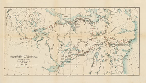
The North-Western Part of the Dominion of Canada, 1898Royal Geographical Society (RGS)Series: LondonRoyal Geographical Society (RGS), The North-Western Part of the Dominion of Canada, 1898£ 495.00
-
Royal Geographical Society (RGS), Great Bear Lake and environs, 1901£ 95.00
-
Royal Geographical Society (RGS), Northeastern Canada, 1903£ 295.00
-
Captain Sverdrup's Arctic Expedition in the 'Fram.' 1899-1902, 1903Scottish Geographical Society (SGS)Series: EdinburghScottish Geographical Society (SGS), Captain Sverdrup's Arctic Expedition in the 'Fram.' 1899-1902, 1903£ 325.00
-
Royal Geographical Society (RGS), Mackenzie Delta, Northwest Territories, 1908£ 425.00
-
John Bartholomew & Son, Manitoba & Northwest Ontario, 1922£ 95.00
-
John Bartholomew & Son, North-Eastern Canada, 1922£ 95.00
-
William Collins, Arctic Coast of Canada, 1923£ 595.00
Northern Canada
Our entire inventory of over 10,000 antique and vintage maps is now available to browse by region, date, cartographer, and subject