-
 Robert de Vaugondy, Southwestern US and northern Mexico, 1749£ 465.00
 -
Herman Moll, Florida and Louisiana, 1750 c.£ 1,250.00
-
Jacques-Nicolas Bellin, Florida and Louisiana coast, 1764£ 4,950.00
-
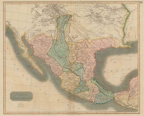
Dr. William Robertson, Southwestern United States and Mexico, 1777£ 1,150.00
-
Antonio Zatta, Mexico, Texas & the Southern USA, 1785£ 795.00
-
Thomas and Andrews, Mexico and Southern United States, 1805£ 225.00
-
Jean-Baptiste Poirson, Texas, Louisiana, Alabama, Mississippi, Florida and Georgia, 1807£ 2,500.00
-
John Pinkerton, Southwestern Unites States, 1811£ 3,500.00
-
John Thomson, Texas, New Mexico, Arizona and Mexico, 1814£ 2,250.00
-
Philippe Vandermaelen, Coast of Texas from Rio del Norte to Sabine River, 1827£ 1,450.00
-
Map - Illustrating the plan of the defences of the Western & North-Western Frontier, 1837Washington HoodSeries: Washington, D.C.Washington Hood, Map - Illustrating the plan of the defences of the Western & North-Western Frontier, 1837£ 625.00
-
-
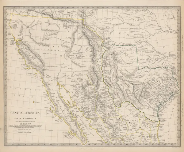
Central America II. Including Texas, California and the Northern States of Mexico, 1842Society for the Diffusion of Useful Knowledge (SDUK)Series: LondonSociety for the Diffusion of Useful Knowledge (SDUK), Central America II. Including Texas, California and the Northern States of Mexico, 1842£ 775.00
-
Carl Flemming, Republic of Texas, 1845 c£ 1,850.00
-
-
Joseph Meyer, Texas, 1846£ 2,650.00
-
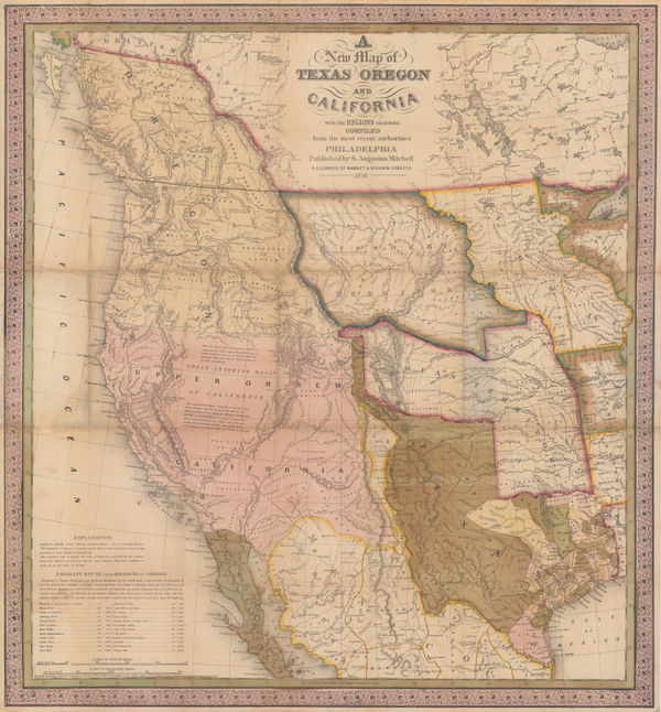
Samuel Augustus Mitchell, Map of Texas from the Most Recent Authorities, 1849£ 1,895.00
-
John Tallis, United States, 1851£ 495.00
-
From Fort Smith to the Rio Grande, 1855United States Pacific Railroad Expeditions (USPRR)Series: Washington, D.C.United States Pacific Railroad Expeditions (USPRR), From Fort Smith to the Rio Grande, 1855£ 1,150.00
-
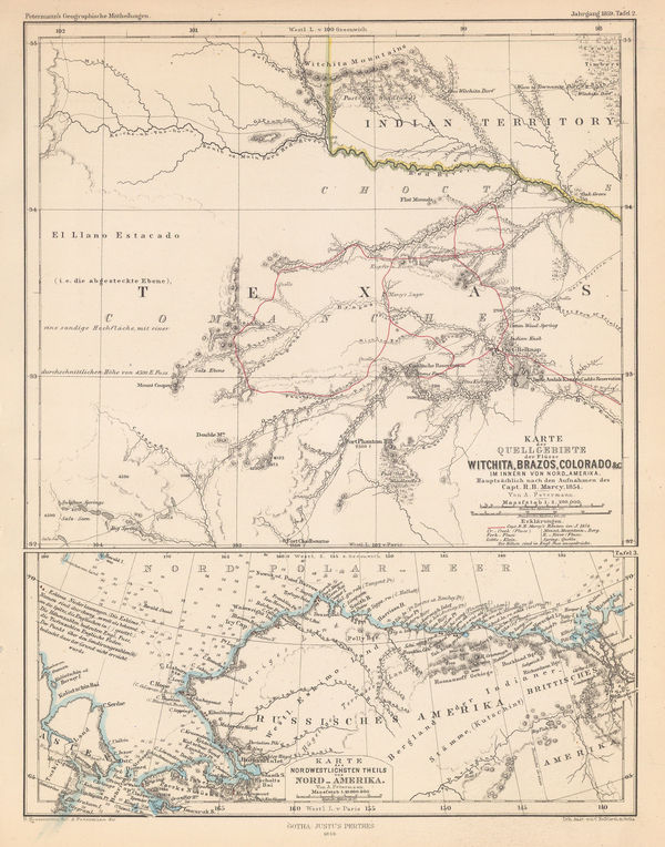
Justus Perthes, North Texas & Alaska, 1859£ 125.00
-
Samuel Augustus Mitchell, County Map of Texas, 1860£ 495.00
-
Map Illustrating the plan of the defences of the Western & North Western Frontier, 1861Washington HoodSeries: PhiladelphiaWashington Hood, Map Illustrating the plan of the defences of the Western & North Western Frontier, 1861£ 525.00
-
Edward Weller, United States [West Sheet], 1863£ 225.00
-
Alvin J. Johnson, Johnson's Texas, 1866£ 445.00
-
Justus Perthes, Indigenous Map of Central and Midwest USA, 1871£ 125.00
-
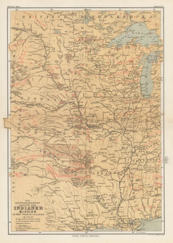
Justus Perthes, [Texasa and Indian Territory], 1876£ 385.00
-
Justus Perthes, Texas, 1880£ 175.00
-
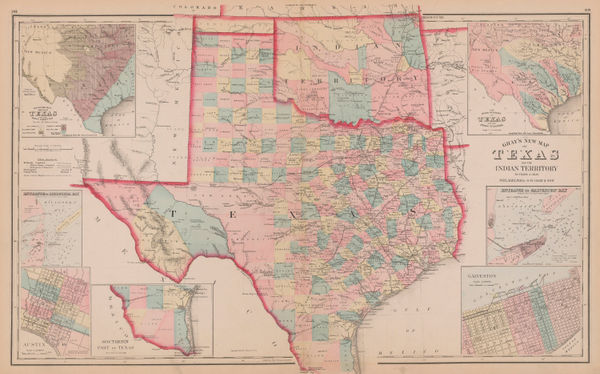
O.W. Gray & Son, Texas and Indian Territory (Oklahoma), 1881£ 1,150.00
-
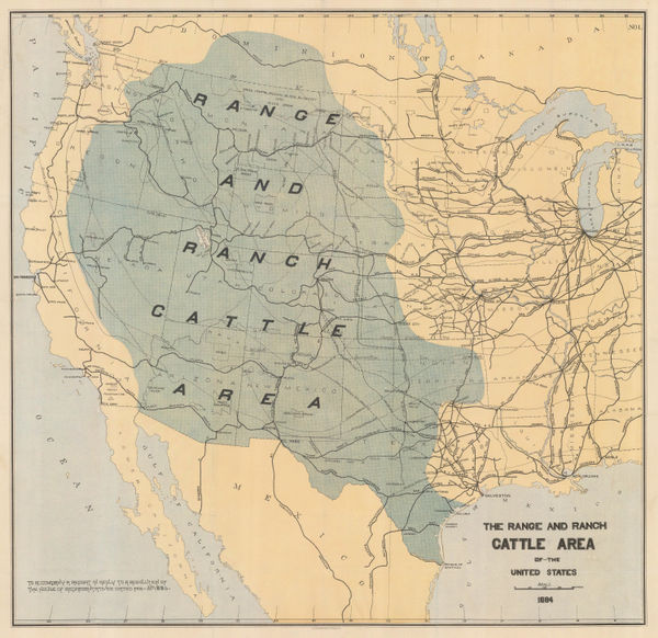
Julius Bien, The Range and Ranch Cattle Area of the United-States, 1884£ 1,650.00
-
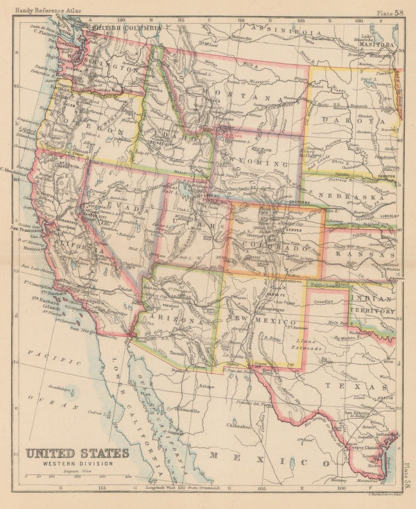
John Bartholomew, United States Western Division, 1887£ 62.00
-
A. Simon, Galveston (1888), 1888£ 425.00
-
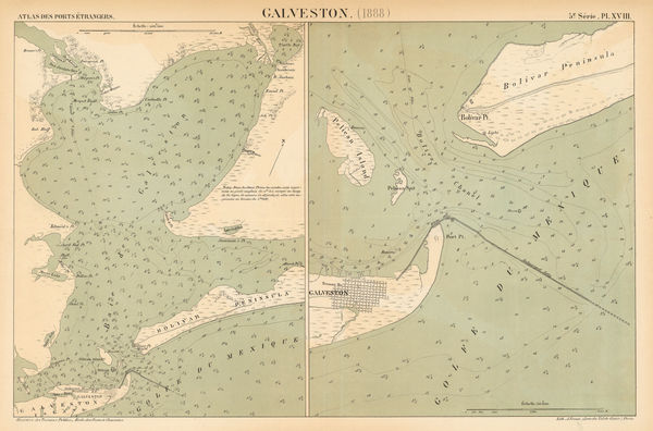
US Government, Galveston Bay, 1888£ 1,750.00
-
G.W. & C.B. Colton & Co., Atchison, Topeka and Santa Fe Railroad System, 1889£ 595.00
-
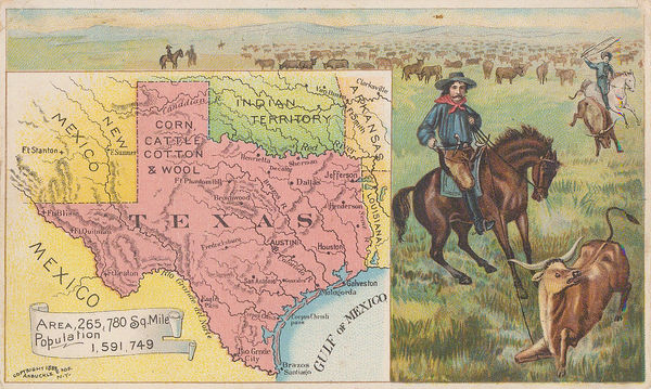
Arbuckle Brothers Company, Texas, 1889£ 295.00
-
Perry Mason & Co., Texas, 1891£ 345.00
-
American Civil War, Coast of Texas and its Defences, 1894£ 495.00
-
American Civil War, Southern Texas, 1894£ 245.00
-
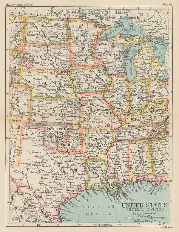
George Philip & Son Ltd., United States - Central Division, 1896£ 36.00
-
George Cram, Texas, 1898£ 485.00
-
Weyss, Map of the United States and Texas Boundary and adjacent Territory, 1902£ 775.00
-
Rand, McNally & Co., Texas, 1906£ 495.00
-
Rand, McNally & Co., The Soash Special, 1909£ 1,850.00
-
Brady Standard Print, McCulloch County Texas, 1918£ 885.00
-
Harrison & Eaton, Map of Ranger-Strawn-Stephens Co. Area, 1920£ 4,500.00
-
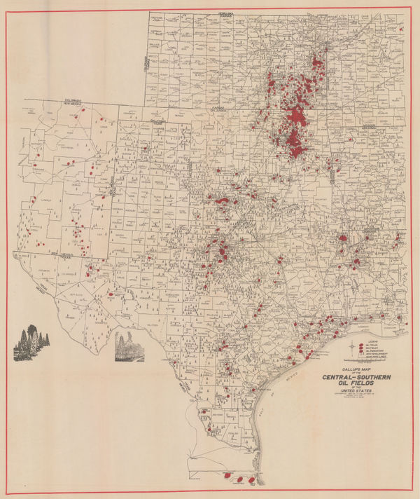
F.E. Gallup, Map of the Central-Southern Oil Fields, 1920£ 3,450.00
-
Map of the Petrolia Gas Fields Texas, 1920United States Geological Survey (USGS)Series: Washington, D.C.United States Geological Survey (USGS), Map of the Petrolia Gas Fields Texas, 1920£ 445.00
-
Nic Tengg, Map of the City of San Antonio, 1924£ 2,250.00
-
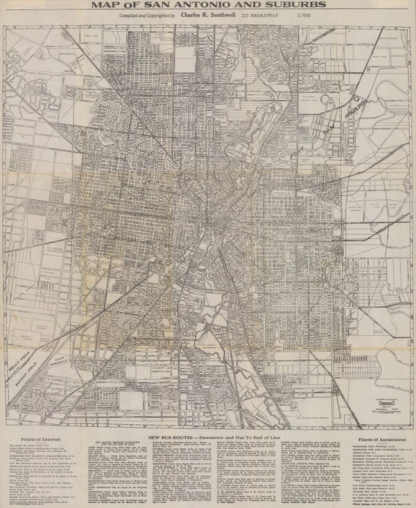
Charles R. Southwell, Map of San Antonio and Suburbs, 1928 c.£ 595.00
-
-
-
J. Foster Ashburn, Chamber of Commerce Map of Dallas Texas, 1938 c.£ 495.00
-
Charles R. Southwell, New Map of Greater San Antonio, 1942 c.£ 950.00
-
J. Foster Ashburn, Ashburn's Fort Worth, Tex, 1943 c£ 295.00
-
J. Foster Ashburn, Ashburn's 1948 Map of Forth Worth, 1948£ 245.00
-
J. Foster Ashburn, Dallas City Map, 1951£ 445.00
-
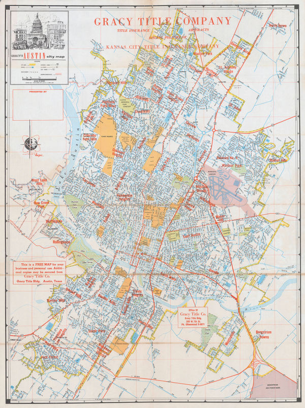
J. Foster Ashburn, Austin, 1952£ 325.00
-
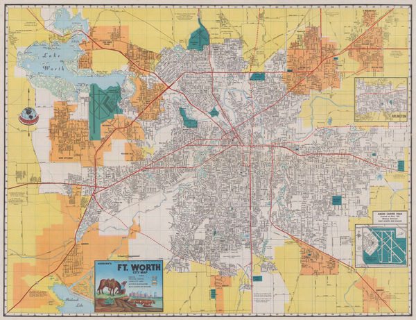
J. Foster Ashburn, Ashburn's Fort Worth City Map, 1956£ 295.00
-
United States Geological Survey (USGS), Austin and Vicinity, 1957£ 950.00
-
J. Foster Ashburn, City Plan of Austin, Texas, 1963£ 650.00
Texas
Our entire inventory of over 10,000 antique and vintage maps is now available to browse by region, date, cartographer, and subject


![Edward Weller, United States [West Sheet], 1863](https://static-assets.artlogic.net/w_600,c_limit,f_auto,fl_lossy,q_auto/artlogicstorage/themaphouse/images/view/3cefd76756f06e726498aa52f2f443cbj/themaphouse-edward-weller-united-states-west-sheet-1863.jpg)

![Justus Perthes, [Texasa and Indian Territory], 1876](https://static-assets.artlogic.net/w_600,c_limit,f_auto,fl_lossy,q_auto/artlogicstorage/themaphouse/images/view/488afc00723c4bf1a468f344f17d5a4dj/themaphouse-justus-perthes-texasa-and-indian-territory-1876.jpg)