-
 Jacques-Nicolas Bellin, Madagascar, Réunion, Mauritius & Comoros, 1764£ 195.00
 -
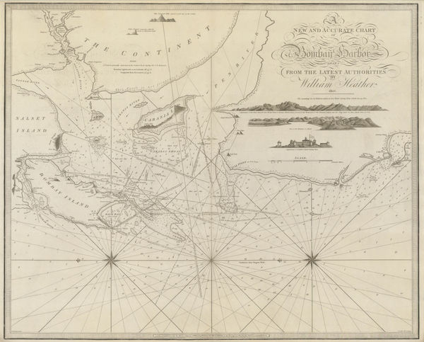
Jacques-Nicolas Bellin, Mumbai and environs, 1764£ 445.00
-
Jacques-Nicolas Bellin, West Bengal & Bangladesh, 1764£ 325.00
-
Jacques-Nicolas Bellin, The Coast of Andhra Pradesh (Coromandel), 1764£ 175.00
-
Thomas Kitchin, A Map of the Coast of Coromandel, 1765 c.£ 425.00
-
Emanuel Bowen, India, Ceylon and part of South East Asia, 1766£ 975.00
-
Thomas Jefferys, The East Indies with the Roads, 1768£ 2,950.00
-
Willem Albert Bachiene, Ryk des Grooten Mogols en dier Indien, 1774£ 985.00
-
A General Map of Indostan or the Great Mogol's Empire with the Adjacent Countries, 1775Robert OrmeSeries: LondonRobert Orme, A General Map of Indostan or the Great Mogol's Empire with the Adjacent Countries, 1775£ 385.00
-
Robert Orme, Sri Lanka (Ceylon) and Coromandel coast , 1775£ 495.00
-
Robert Orme, Coromandel from the Coleroon to Cape Comorin, 1778£ 645.00
-
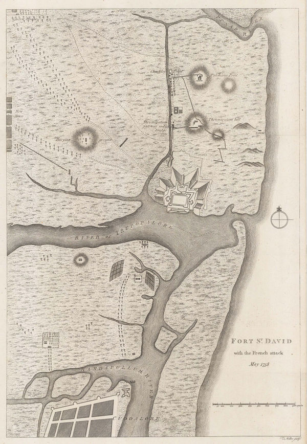
Robert Orme, Fort St. David, Cuddalore, 1778£ 425.00
-
Robert Orme, Chennai (Madras) during the Siege of Madras, 1778£ 945.00
-
Robert Orme, Military Intelligence plan of Kolkata (Calcutta) , 1778£ 885.00
-
Robert Orme, Fort St. George, Chennai (Madras), 1778£ 945.00
-
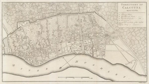
Robert Orme, Territory of Calcutta (Kolkata), 1778£ 885.00
-
Robert Orme, The Carnatic from the Pennar to the Coleroon, 1778£ 495.00
-
James Rennell, Jungleterry District, 1779£ 295.00
-
Robert Orme, Thanjavur (Tanjore), 1779£ 585.00
-
Rigobert Bonne, Mauritius, Réunion & Rodrigues, 1780 c£ 375.00
-
Plan of the Bay and Harbour of Trincomalay, on the Island of Ceylon, 1780 c.Jean-Baptiste d'Après de MannevilletteSeries: ParisJean-Baptiste d'Après de Mannevillette, Plan of the Bay and Harbour of Trincomalay, on the Island of Ceylon, 1780 c.£ 975.00
-
Jean Lattré, India, Sri Lanka & the Maldives, 1780 c.£ 785.00
-
John Bew, Southern India, 1781£ 245.00
-
Robert Orme, Central India, 1782£ 225.00
-
Robert Orme, Southern India - Tamil Nadu & Kerala, 1782£ 225.00
-
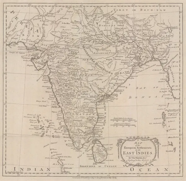
Thomas Kitchin, European Settlements in the East Indies, 1783£ 645.00
-
Joseph Tiefenthaler, The River Ganges, 1784£ 4,500.00
-
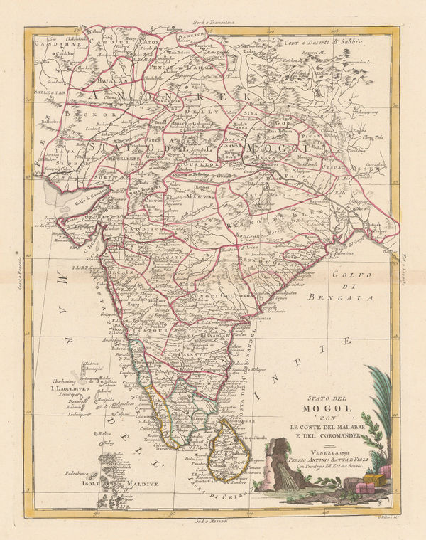
Antonio Zatta, Stato del Mogol, 1785£ 795.00
-
James Rennell, Ganges Delta, 1785£ 1,450.00
-
Charles Theodore Middleton, India and the East Indies, 1790 c.£ 325.00
-
William Faden, The Southern Countries of India from Madrass to Cape Comorin, 1791£ 3,950.00
-
James Rennell, Afghanistan, Pakistan, India and Turkestan, 1792£ 445.00
-
Laurie & Whittle, A Chart of the Coast of India, from Goa to Cape Comorin, 1794£ 1,250.00
-
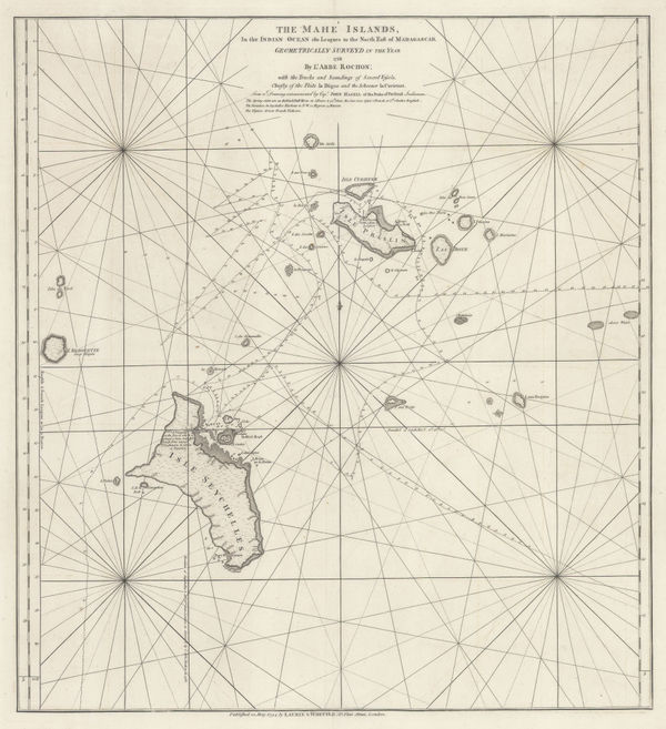
Laurie & Whittle, A Chart of the Mahe and Amirantes Islands, 1794£ 2,450.00
-
Laurie & Whittle, A Chart of the Nicobar Islands in the Gulf of Bengal, 1794£ 750.00
-
Laurie & Whittle, Uttar Pradesh, 1794£ 450.00
-
Laurie & Whittle, Chart of entrance to the Hooghly River, 1794£ 1,650.00
-
-
The Coast of India between Calymere and Gordeware Points including the Coast of Coromandel, 1794Laurie & WhittleSeries: LondonLaurie & Whittle, The Coast of India between Calymere and Gordeware Points including the Coast of Coromandel, 1794£ 1,250.00
-
Laurie & Whittle, The Coast of India from Point Gordeware to the Ganges, 1794£ 985.00
-
Laurie & Whittle, The Coast of India from Point Jigat to Cape Ramas, 1794£ 1,250.00
-
Laurie & Whittle, The Seychelles, or Mahe Islands, 1794£ 2,450.00
-
Laurie & Whittle, Plan of the Harbour of Colombo, on the West Coast of Ceylon, 1797£ 925.00
-
Pierre Tardieu, Southern India and Sri Lanka (Ceylon), 1798£ 175.00
-
William Faden, India and Southeast Asia, 1798£ 175.00
-
John Walker, Hindoostan, or India, 1798£ 75.00
-
William Faden, A Map of the Peninsula of India, 1800£ 1,550.00
-
George Cooke, Hindoostan, 1800£ 325.00
-
-
William Heather, Sea chart of the Bay of Bengal, 1803£ 2,250.00
-
Robert Orme, Pondicherry, 1803£ 265.00
-
Jean-Baptiste Poirson, India, 1803£ 525.00
-
Rare French derivation of Aaron Arrowsmith's 1803 map of Ceylon (Sri Lanka), 1803 c.Aaron ArrowsmithSeries: FranceAaron Arrowsmith, Rare French derivation of Aaron Arrowsmith's 1803 map of Ceylon (Sri Lanka), 1803 c.£ 775.00
-
-
-
India & the Middle East as it was known during the Classical Era, 1807Robert WilkinsonSeries: LondonRobert Wilkinson, India & the Middle East as it was known during the Classical Era, 1807£ 115.00
-
Charles Smith, Peninsula of India, 1808£ 115.00
-
Robert Wilkinson, The Southern Provinces of Hindoostan, 1808£ 115.00
-
Aaron Arrowsmith & Samuel Lewis, Hindoostan, 1812£ 125.00
-
John Thomson, Southern India, 1816£ 195.00
-
John Thomson, Northern India, Nepal & Afghanistan, 1817£ 495.00
-
Richard Phillips, Hindoostan, 1820£ 98.00
-
Daniel & William Lizars, India, or Hindoostan, 1820 c.£ 145.00
-
A Geological Sketch of Malwa, and part of the Adjoining Provinces, 1823Capt. F. DangerfieldSeries: LondonCapt. F. Dangerfield, A Geological Sketch of Malwa, and part of the Adjoining Provinces, 1823£ 95.00
-
Map of Central India, including Malwa, and the adjoining provinces, 1823Aaron ArrowsmithSeries: LondonAaron Arrowsmith, Map of Central India, including Malwa, and the adjoining provinces, 1823£ 445.00
-
Aaron Arrowsmith, Hindoostan, 1829£ 125.00
-
Alexandre Emile Lapie, The Middle East, 1831£ 495.00
-
Society for the Diffusion of Useful Knowledge (SDUK), Eastern India, 1832£ 35.00
-
Society for the Diffusion of Useful Knowledge (SDUK), Northwest India, 1833£ 75.00
-
Royal Geographical Society (RGS), Sketch of Part of the Himma-Leh Mountains, 1834£ 120.00
-
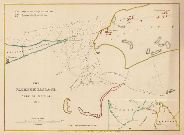
Royal Geographical Society (RGS), Chart of the Palk Strait (Paumbum Passage), 1834£ 125.00
-
Charles Smith, Map of India Exhibiting its Present Political Divisions, 1835£ 695.00
-
British Admiralty, The Harbour and Bays of Trincomalee, 1835 c.£ 490.00
-
Adrien Brue, Indian and Southeast Asia showing European colonial possessions, 1836£ 245.00
-
James Wyld, Map of the Countries lying between Turkey and Burmah, 1839£ 2,450.00
-
Northeastern India - Bahar and Orissa, 1840 c.Society for the Diffusion of Useful Knowledge (SDUK)Series: LondonSociety for the Diffusion of Useful Knowledge (SDUK), Northeastern India - Bahar and Orissa, 1840 c.£ 45.00
-
James Wyld, Map of the Peninsula of India, 1840 c.£ 695.00
-
John Walker, Map of the Countries on the North West Frontier of India, 1841£ 4,850.00
-
Map of Afghaunistan, Caubul, The Punjab, Rajpootana and the River Indus, 1842James WyldSeries: LondonJames Wyld, Map of Afghaunistan, Caubul, The Punjab, Rajpootana and the River Indus, 1842£ 1,950.00
-
James Wyld, Map of India, 1843£ 2,250.00


Page
2
of 6