-
 Martin Waldseemüller & Laurent Fries, Crete, 1541£ 1,750.00
 -
Sebastian Münster, Early map of Crete, 1558£ 145.00
-
Sebastian Münster, Nova Graecia, 1572£ 695.00
-
Georg Braun & Frans Hogenberg, Corfu Town & Chania, Crete, 1575 c.£ 1,250.00
-
Tomaso Porcacchi, Early map of Milos, 1576Sold
-
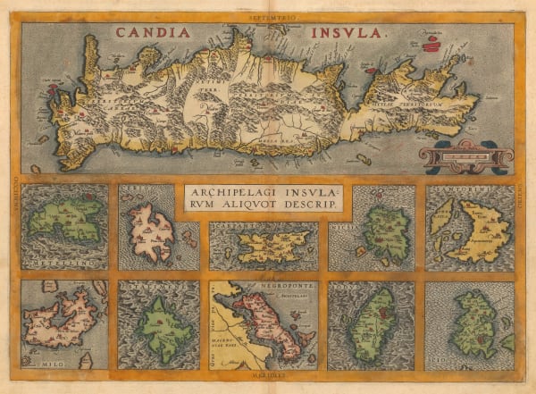
Abraham Ortelius, Crete & the Greek Islands, 1592£ 950.00
-
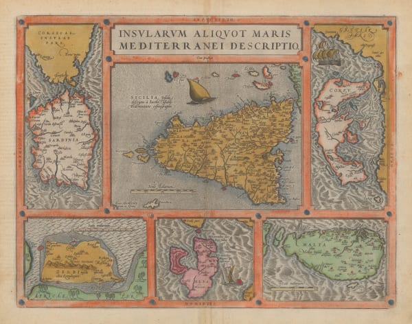
Abraham Ortelius, Sicily, Sardinia, Corfu, Malta, Elba, & Djerba, 1598£ 850.00
-
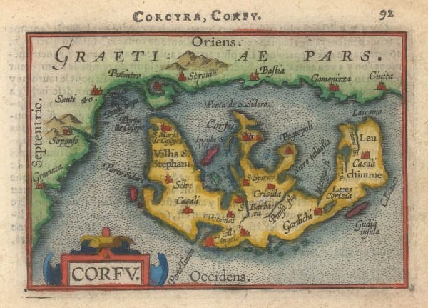
Abraham Ortelius, Miniature map of Corfu, 1601Sold
-
Samuel Purchas, Crete, Corfu, Zante, Milos, Naxos & Karpathos, 1625£ 425.00
-
Mercator Hondius, Crete, Corfu, Zante, Milos, Naxos, Santorini & Karpathos, 1628Sold
-
Mercator Hondius, Crete, Corfu, Zante, Milos, Naxos, Santorini & Karpathos, 1630 c.£ 725.00
-
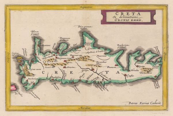
Jan Jansson, Ancient Crete, 1661£ 245.00
-
Willem & Jan Blaeu, Cyclades & Dodecanese Islands, 1662£ 1,750.00
-
Willem & Jan Blaeu, Crete, 1662 (c.)£ 345.00
-
Willem & Jan Blaeu, Northern Aegean Islands, 1662 (c.)£ 950.00
-
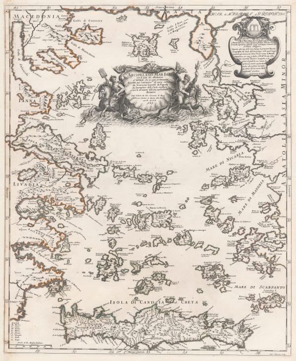
Giovanni Giacomo Rossi, Aegean Sea, 1684£ 1,850.00
-
Vincenzo Coronelli, Cyclades, Dodecanese & Southern Aegean Islands, 1692£ 1,200.00
-
Vincenzo Coronelli, Corfu, Paxos & Antipaxos, 1696£ 785.00
-
Vincenzo Coronelli, Sea chart of Crete, 1696£ 845.00
-
Vincenzo Coronelli, Rhodes, 1696£ 475.00
-
Vincenzo Coronelli, Crete, 1696£ 1,850.00
-
Olfert Dapper, The City and Harbour of Rhodes, 1702£ 375.00
-
Pieter van der Aa, Corfu, 1714Sold
-
Alain Manesson Mallet, Corfu, 1719£ 295.00
-
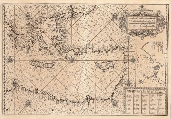
Henri Michelot and Laurent Brémond, Eastern Mediterranean Sea Chart, 1726£ 2,650.00
-
Joseph Roux, Corfu, 1764£ 185.00
-
Jacques-Nicolas Bellin, Plan of Chania, Crete, 1764£ 125.00
-
Jacques-Nicolas Bellin, Plan of Heraklion, Crete, 1764£ 125.00
-
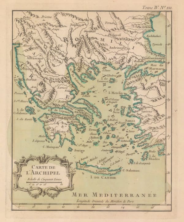
Greece, the Aegean Sea, the Greek Archipelago and western Anatolia, 1764Jacques-Nicolas BellinSeries: FranceJacques-Nicolas Bellin, Greece, the Aegean Sea, the Greek Archipelago and western Anatolia, 1764£ 195.00
-
Jacques-Nicolas Bellin, Crete, 1764£ 245.00
-
Pierre Tardieu, Corfu, 1802 c.£ 325.00
-
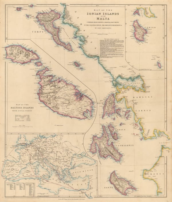
John Arrowsmith, Map of the Ionian Islands and Malta, 1844£ 325.00
-
Royal Geographical Society (RGS), Ruins of Ancient Milos, 1852£ 88.00
-
Justus Perthes, Santorini, 1866£ 68.00
-
Justus Perthes, Ethnographic Map of Crete, 1866£ 245.00
-
Royal Geographical Society (RGS), Milos, Anti-Milos, Kimolos & Poliegos, 1870 c.£ 125.00
-
Justus Perthes, The Island of Icaria, 1894£ 175.00
-
Edward Stanford, Map of the Ionian Islands and Malta, 1898£ 275.00
-
Edward Stanford, The Aegean Sea & Greek Islands, 1904£ 85.00
-
British Admiralty, Aegean Sea and Islands, 1922£ 1,450.00
-
Anonymous, Kefalonia & Ithaca, 1970 c£ 120.00
Greek Islands
Our entire inventory of over 10,000 antique and vintage maps is now available to browse by region, date, cartographer, and subject