Maps of the whole of London
-

-
-
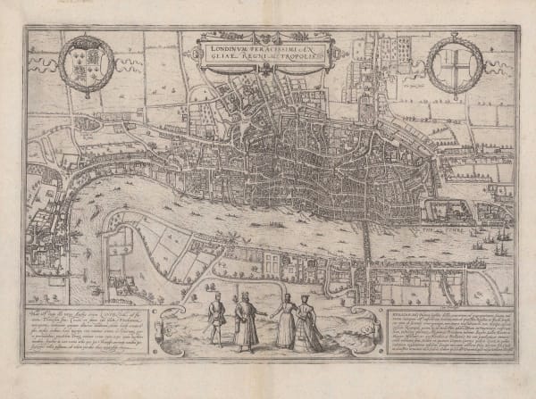
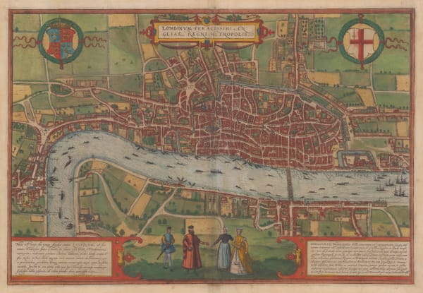
Sebastian Münster, Elizabethan London, 1598 c.£ 2,500.00
-
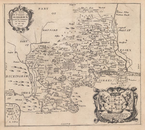
John Norden & William Kip, Middlesex, or North & West London, 1637£ 850.00
-
An 1863 Reprint of Newcourt's Pre-Fire Map of London, 1658 (1863)Richard Newcourt & Edward StanfordSeries: LondonRichard Newcourt & Edward Stanford, An 1863 Reprint of Newcourt's Pre-Fire Map of London, 1658 (1863)£ 4,500.00
-
Matthäus Merian, The Great Fire of London, 1670 c.£ 1,500.00
-
Richard Blome, Middlesex, or North & West London, 1673£ 475.00
-
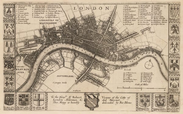
Richard Blome, London, 1673Reserved
-
Matthäus Merian, London after the Great Fire, 1677 c.£ 1,950.00
-
-
John Seller, Middlesex, 1690 c.£ 195.00
-
Vincenzo Coronelli, London, 1696£ 2,250.00
-
Nicolas de Fer, London & Westminster, 1700£ 885.00
-
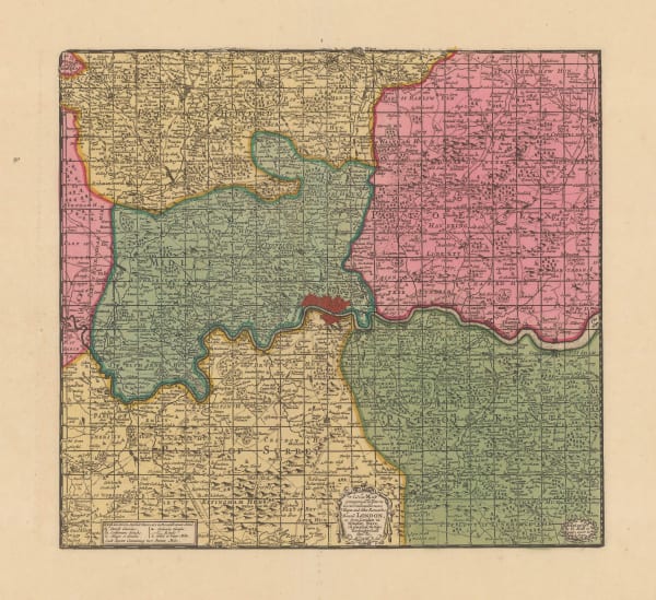
Herman Moll, London and its Environs 20 Miles Around, 1700 c.£ 375.00
-
Johann Baptist Homann, Map and Panoramic View of London, 1700 c.£ 4,950.00
-
Edward Hatton, A New Map of the Cityes of London, Westminster & Southwark, 1708£ 3,850.00
-
Edward Hatton, A Plan of London, Westminster and Southwark, 1708£ 4,950.00
-
Morden & Lea, Actuale Survey of London, 1710 c.£ 4,850.00
-
Nouvelle Carte du Gouvernement Civil d'Angleterre et Celuy de la Ville de Londres, 1719Henri ChatelainSeries: ParisHenri Chatelain, Nouvelle Carte du Gouvernement Civil d'Angleterre et Celuy de la Ville de Londres, 1719£ 250.00
-
John Stow, Lambeth & Southwark, 1720£ 175.00
-
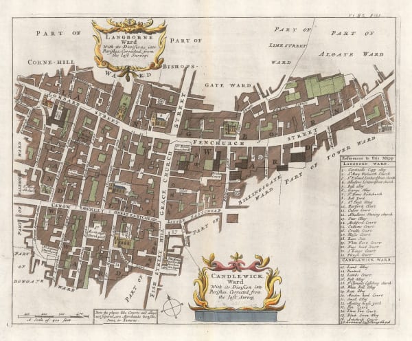
John Stow, Langborne Ward & Candlewick Ward, 1720£ 250.00
-
John Stow, Shoreditch, Old Street, Moorgate & Hoxton, 1720£ 395.00
-
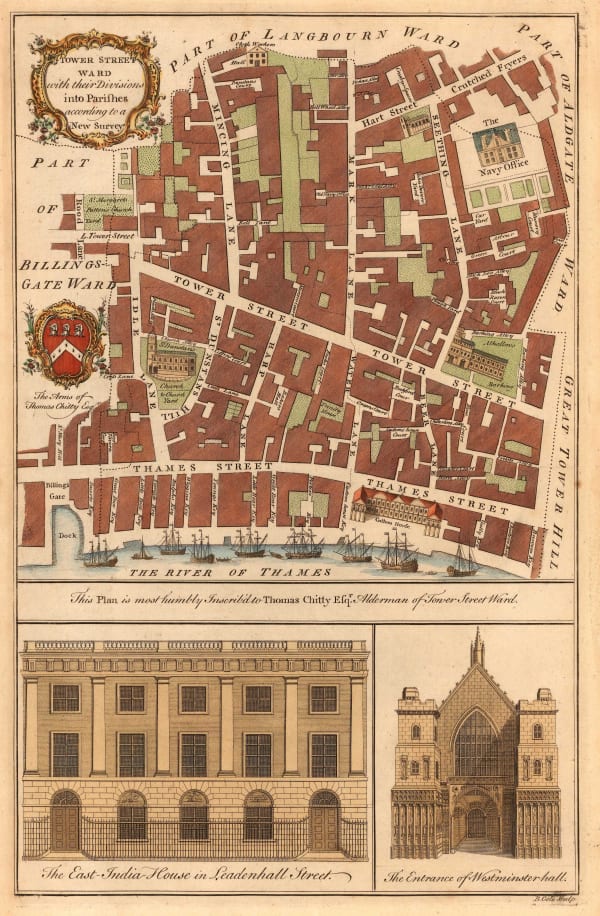
John Stow, Tower Street Ward, 1720£ 395.00
-
George Willdey, London and 30 Miles Around, 1720 c.£ 2,450.00
-
Gabriel Bodenehr, London, Westminster & Southwark, 1720 c.£ 885.00
-
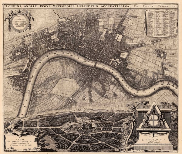
Pieter van der Aa, London after the Glorious Revolution, 1720 c.£ 3,950.00
-
John Norden, Westminster, 1723£ 295.00
-
-
John Rocque, Plan of the Royal Palace and Gardens of Hampton Court Palace, 1736£ 1,150.00
-
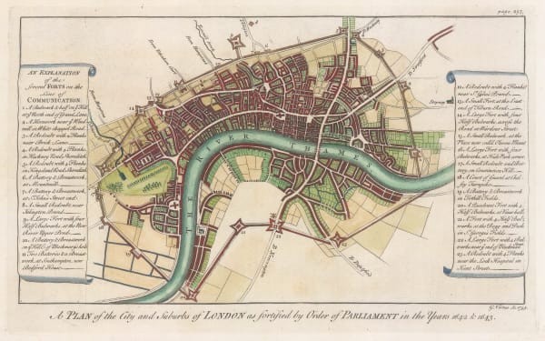
George Vertue, London during the English Civil War, 1738£ 395.00
-
Matthaus Seutter, London and its Environs, 1740 c.£ 1,850.00
-
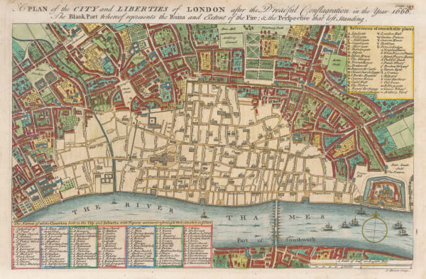
A Plan of the City and Liberties of London after the Dreadful Conflagration in the Year 1666, 1740 c.Emanuel BowenSeries: LondonEmanuel Bowen, A Plan of the City and Liberties of London after the Dreadful Conflagration in the Year 1666, 1740 c.£ 575.00
-
Regionis, qvae est circa Londinvm specialis repraesentatio geographica, 1741Homann HeirsSeries: NurembergHomann Heirs, Regionis, qvae est circa Londinvm specialis repraesentatio geographica, 1741£ 1,650.00
-
Georges-Louis Le Rouge, Les Environs de Londres, 1745£ 895.00
-
William Maitland, Aldersgate Ward, 1754£ 345.00
-
William Maitland, Billinsgate Ward and Bridge Ward Within, 1754£ 245.00
-
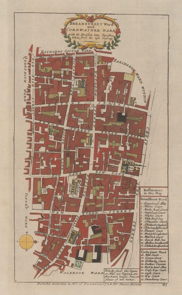
John Stow, Breadstreet Ward and Cordwainer Ward, 1754£ 145.00
-
Isaac Tirion, Kaart van Londen, 1754£ 1,350.00
-
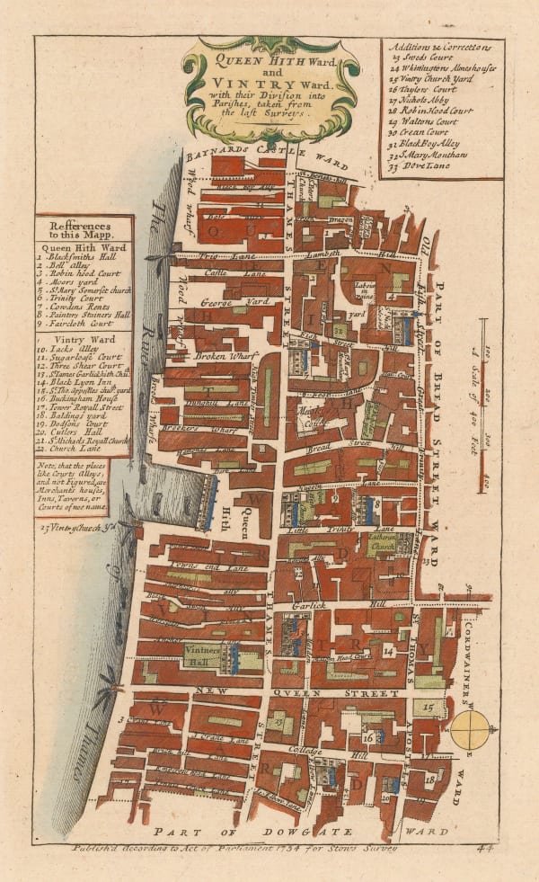
William Maitland, Queenhithe Ward and Vintry Ward, 1754£ 195.00
-
John Stow, A Map of the Tower Liberty, 1754£ 395.00
-
John Stow, Old Street, Barbican & Moorfields, 1755£ 395.00
-
William Maitland, Islington, Holborn, Clerkenwell & Farringdon, 1755£ 475.00
-
Cheap Ward with its Divisions into Parishes According to a New Survey, 1755William MaitlandSeries: LondonWilliam Maitland, Cheap Ward with its Divisions into Parishes According to a New Survey, 1755£ 445.00
-
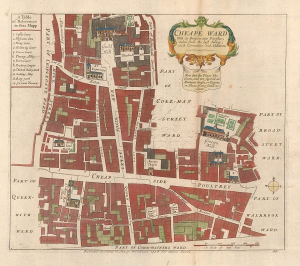
John Stow, Cheape Ward, 1755£ 325.00
-
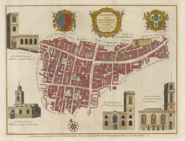
William Maitland, Langborne Ward and Candlewick Ward, 1755£ 775.00
-
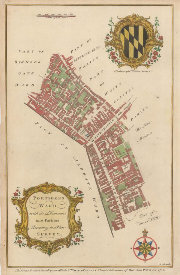
William Maitland, Portsoken Ward, Aldgate, 1755£ 95.00
-
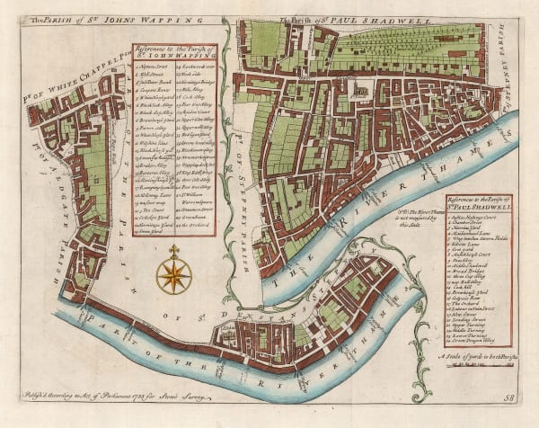
John Stow, Wapping & Shadwell, 1755£ 240.00
-
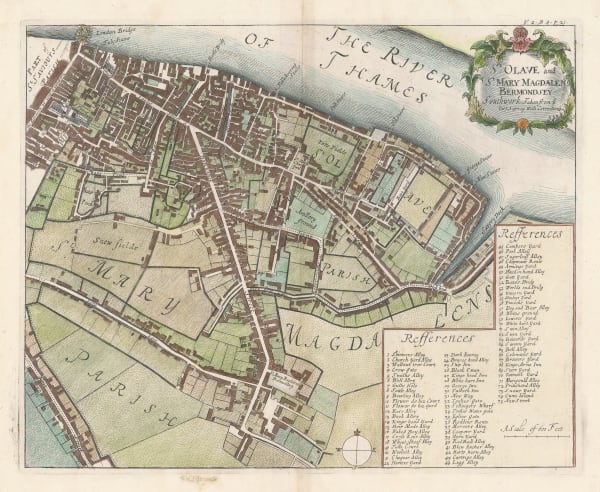
John Stow, London Bridge & Bermondsey, 1755£ 295.00
-
John Stow, A Map of the Parish of St. Mary Whitechapel, 1755£ 325.00
-
John Stow, Coleman Street Ward and Bashishaw Ward, 1755£ 285.00
-
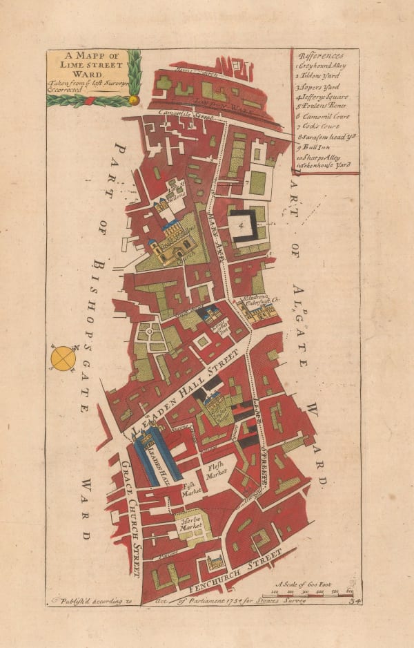
John Stow, A Mapp of Lime Street Ward, 1755 c.£ 118.00
-
London Magazine, A Plan of the New Road from Paddington to Islington, 1756£ 75.00
-
William Maitland, Aldgate Ward, 1756£ 165.00
-
William Maitland, Breadstreet Ward and Cordwainers Ward, 1756£ 245.00
-
William Maitland, The Wards of Coleman Street and Bassishaw, 1756£ 265.00
-
Tower Street Ward with their Divisions into Parishes according to a New Survey, 1756William MaitlandSeries: LondonWilliam Maitland, Tower Street Ward with their Divisions into Parishes according to a New Survey, 1756£ 220.00
-
William Maitland, Walbrook Ward and Dowgate Ward, 1756£ 245.00
-
John Rocque, Middlesex, or North & West London, 1757£ 1,450.00
-
A Plan of the Roads and Streets from Islington to Dog House Bar delineated to shew a New Road, 1760London MagazineSeries: LondonLondon Magazine, A Plan of the Roads and Streets from Islington to Dog House Bar delineated to shew a New Road, 1760£ 85.00
-
Robert & James Dodsley, London, Westminster, and Southwark, 1761Reserved
-
-
Jacques-Nicolas Bellin, Plan de la Ville de Londres, 1764£ 595.00
-
London Magazine, Breadstreet Ward and Cordwainers Ward, 1766£ 145.00
-
John Gwynn, Hyde Park, Mayfair and Westminster, 1766£ 1,650.00
-
London Magazine, Candlewick and Langborne Wards, 1768£ 135.00
-
Russell & Price, Middlesex, 1769£ 115.00
-
London Magazine, Queen Hith and Vintry Wards, 1771£ 115.00
-
London Magazine, Walbrook Ward and Dowgate Ward, 1772£ 125.00
-
Thomas Bowen, County of Middlesex, 1777£ 585.00
-
The London Directory, or a New & Improved Plan of London, Westminster, & Southwark, 1784Robert WilkinsonSeries: LondonRobert Wilkinson, The London Directory, or a New & Improved Plan of London, Westminster, & Southwark, 1784£ 1,350.00
-
A New and Correct Plan of the Citie of London, Westminster and Borough of Southwark, 1785Robert SayerRobert Sayer, A New and Correct Plan of the Citie of London, Westminster and Borough of Southwark, 1785£ 1,850.00
-
A Plan of the Cities of London and Westminster, The Borough of Southwark and their Suburbs, 1785William FadenWilliam Faden, A Plan of the Cities of London and Westminster, The Borough of Southwark and their Suburbs, 1785£ 2,750.00
-
-
John Cary, The London Docks, 1794£ 895.00
-
Richard Horwood, Knightsbridge, 1794£ 1,950.00
-
George Bickham, Bird's-Eye view of London, 1796£ 550.00
-
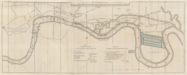
John Stockdale, The Proposed London Docks, 1796£ 650.00
-
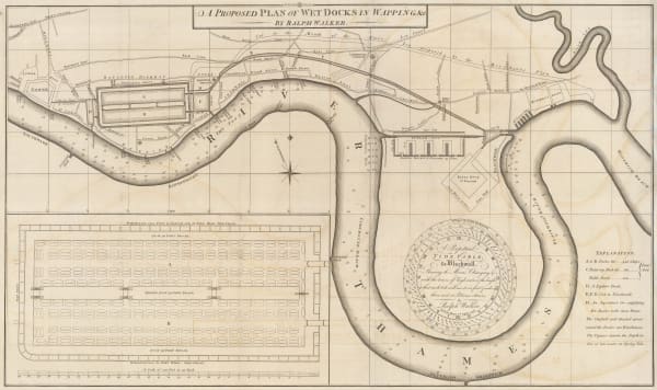
John Stockdale, A Proposed Plan of Wet Docks in Wapping, 1796£ 850.00
-
John Wallis, Wallis's Plan of the Cities of London and Westminster, 1797£ 1,950.00
-
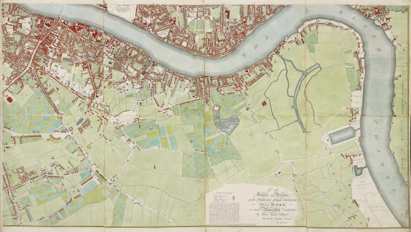
Richard Horwood, Southwark, Bermondsey, Rotherhithe & Wapping, 1799£ 4,850.00


Page
1
of 8