-
 Letts & Son, E. Riding, 1889£ 48.00
 -
Ordnance Survey, Geological Survey of England and Wales, 1889£ 375.00
-
Letts & Son, Lincoln, 1889£ 54.00
-
Letts & Son, Worcester, 1889£ 42.00
-
George W. Bacon, Oxford, 1890 (c.)£ 495.00
-
Edward Weller, Cheshire, 1890 c.£ 35.00
-
F. Curtis, Bath, 1890 c.£ 895.00
-
Anthony Brown & Sons Ltd., Hull, 1890 c.£ 185.00
-
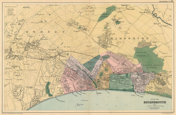
George W. Bacon, Bournemouth, 1890 c.£ 145.00
-
George W. Bacon, Leeds, 1890 c.£ 125.00
-
George W. Bacon, Portsmouth, 1890 c.£ 90.00
-
Thomas Kelly, Surrey, 1890 c.£ 450.00
-
George W. Bacon, Brighton, 1890 c.£ 245.00
-
George W. Bacon, Plan of Southampton, 1890 c.£ 98.00
-
George W. Bacon, Plan of Chatham and Rochester, 1890 c.£ 115.00
-
Alden & Co, Plan of Oxford, 1890 c.£ 275.00
-
George W. Bacon, The Isle of Wight, 1890 c.£ 75.00
-
Ordnance Survey, Geological Survey of England and Wales, 1891£ 120.00
-
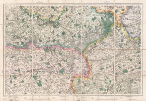
Ordnance Survey, Geological Survey of the River Humber, 1891£ 375.00
-
Ordnance Survey, Geological Survey of England and Wales, 1892£ 120.00
-
J.F. Bright, Bournemouth, 1892£ 375.00
-
The General Election 1892 & The Graphic Parliamentary Map [Sold as a Pair], 1892The Graphic MagazineSeries: LondonThe Graphic Magazine, The General Election 1892 & The Graphic Parliamentary Map [Sold as a Pair], 1892£ 950.00
-
Ordnance Survey, Isle of Wight, 1893£ 325.00
-
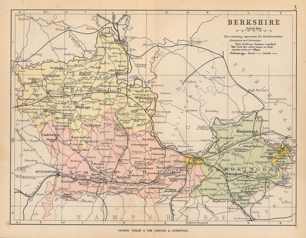
George W. Bacon, Berkshire, 1895£ 32.00
-
George W. Bacon, Dorsetshire, 1895£ 35.00
-
George W. Bacon, Staffordshire, 1895£ 35.00
-
Ordnance Survey, The Country around Faringdon, 1895£ 295.00
-
Ordnance Survey, The Country around High Wycombe, 1895£ 295.00
-
Ordnance Survey, The Country around Sandhurst, 1895£ 295.00
-
George Philip & Son Ltd., The County of Berkshire, 1895£ 22.00
-
George Philip & Son Ltd., The County of Dorset, 1895£ 35.00
-
George Philip & Son Ltd., The County of Wiltshire, 1895£ 20.00
-
George W. Bacon, Manchester, 1895£ 145.00
-
George W. Bacon, Sussex, 1895£ 75.00
-
George W. Bacon, Sheffield, 1895£ 145.00
-
George W. Bacon, Cheltenham, 1895£ 95.00
-
George W. Bacon, Hastings and St. Leonards, 1895£ 85.00
-
W. & A.K. Johnston, Railway Map of England and Wales, 1895£ 795.00
-
George W. Bacon, Cornwall, 1895£ 115.00
-
George Philip & Son Ltd., Lincolnshire, 1895£ 55.00
-
George W. Bacon, Tunbridge Wells, 1895 (c.)£ 225.00
-
George Philip & Son Ltd., The County of Essex, 1895 c.£ 50.00
-
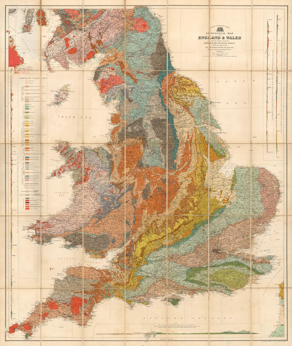
Sir Archibald Geikie, Geological Map of England & Wales, 1897 (c.)£ 550.00
-
Ordnance Survey, Surrey - Haslemere to Godalming, 1898 c.£ 850.00
-
Edward Stanford, Map of the English Lake District, 1899£ 395.00
-
One-Inch OS Map of Stratford-upon-Avon, Leamington Spa & Banbury, 1899Ordnance SurveySeries: SouthamptonOrdnance Survey, One-Inch OS Map of Stratford-upon-Avon, Leamington Spa & Banbury, 1899£ 295.00
-
Charles Edward Goad, Cambridge, 1900£ 325.00
-
Ordnance Survey, Windsor and Ascot, 1900£ 1,200.00
-
J.G. Bartholomew, Cambridge, 1900 c£ 145.00
-
George W. Bacon, Bolton, 1900 c.£ 175.00
-
George W. Bacon, Bradford, 1900 c.£ 95.00
-
George W. Bacon, Brighton & Hove, 1900 c.£ 395.00
-
Andrew Iredale, Torquay, 1900 c.£ 450.00
-
George W. Bacon, Plan of Cheltenham, 1900 c.£ 225.00
-
John Bartholomew & Co., Brighton, 1900 c.£ 195.00
-
George W. Bacon, Large Scale Plan of Newcastle, 1900 c.£ 395.00
-
John Bartholomew, Manchester and Salford, 1900 c.£ 375.00
-
Bacon's County Map and Guide, Gloucester with parts of Adjoining Counties, 1901 c.George W. BaconSeries: LondonGeorge W. Bacon, Bacon's County Map and Guide, Gloucester with parts of Adjoining Counties, 1901 c.£ 75.00
-
George Philip & Son Ltd., Ipswich and Environs, 1902£ 275.00
-
Waterlow & Sons, The Isle of Wight, 1902£ 150.00
-
Baddeley and Ward, Penzance, 1903£ 45.00
-
Emil Reich, Battle of Marston Moor and Battle of Naseby, 1903£ 55.00
-
Emil Reich, Roman Britain, 1903£ 58.00
-
Emil Reich, Wars of the Roses, 1903£ 55.00
-
Ordnance Survey, Geological Survey of England and Wales, 1904£ 150.00
-
George W. Bacon, Oxford, 1905 (c.)£ 525.00
-
George Philip & Son Ltd., Perrier Motor Map of England & Wales, 1906 (c.)£ 295.00
-
Ordnance Survey, Geological Survey of England and Wales, 1907£ 120.00
-
Ordnance Survey, Geological Survey of England and Wales Sheet 18 & Part of 17, 1907£ 150.00
-
Ordnance Survey, Geological Map of Oxford & Environs, 1908£ 175.00
-
Enciclopedia Segui, Birmingham, 1910 (c.)£ 55.00
-
George W. Bacon, Folkestone, 1910 c£ 325.00
-
George W. Bacon, Hampshire (North Division), 1910 c.£ 42.00
-
George W. Bacon, Map of Cornwall, 1910 c.£ 485.00
-
L.A. Smart, Gloucester, 1910 c.£ 95.00
-
J.G. Bartholomew, Oxford, 1910 c.£ 195.00
-
George W. Bacon, Richardson's Map of South East and Central England, 1910 c.£ 345.00
-
J.F. Bennet, Bennet's Map of the River Thames from Oxford to Gravesend, 1910 c.£ 1,350.00
-
George W. Bacon, Southern Hampshire, 1910 c.£ 55.00
-
MacMillan & Co, Plan of Eton College, 1911£ 95.00


![The Graphic Magazine, The General Election 1892 & The Graphic Parliamentary Map [Sold as a Pair], 1892](https://static-assets.artlogic.net/w_600,c_limit,f_auto,fl_lossy,q_auto/artlogicstorage/themaphouse/images/view/482cbe78e7901f3a280f8da45f96c026j/themaphouse-the-graphic-magazine-the-general-election-1892-the-graphic-parliamentary-map-sold-as-a-pair-1892.jpg)


Page
13
of 15