-
 Charles Frederick Cheffins, Map of the English and Scottish Railways, 1843£ 475.00
 -
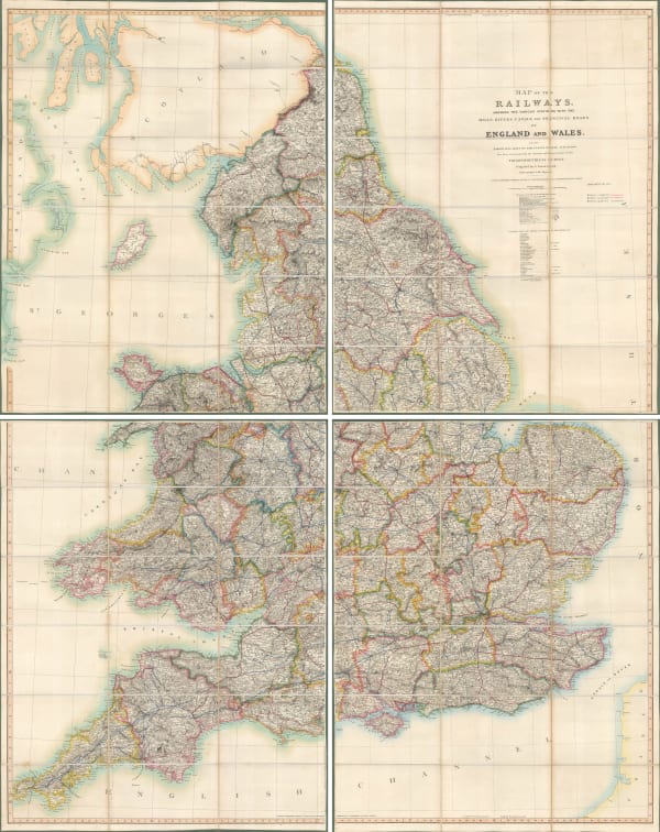
Map of the Railways Showing the Various Stations with the Hills, Rivers, Canals and Principal Roads of England and Wales, 1845Aaron ArrowsmithSeries: LondonAaron Arrowsmith, Map of the Railways Showing the Various Stations with the Hills, Rivers, Canals and Principal Roads of England and Wales, 1845£ 2,450.00
-
James Wyld, Post Map of Europe, 1845£ 450.00
-
James Wyld, Railway Map of England Wales and Scotland, 1845£ 1,850.00
-
John Tallis, Tallis's Railway Map of Great Britain, 1851£ 475.00
-
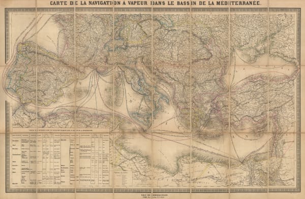
Andriveau-Goujon, Mediterranean Steamship Routes, 1851£ 650.00
-
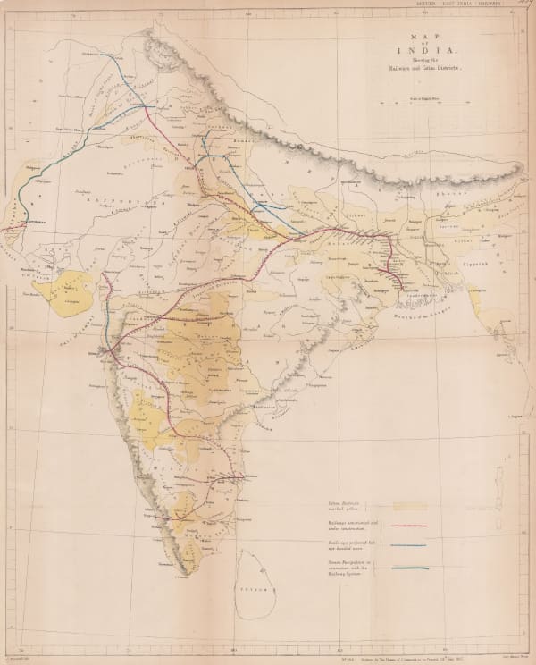
Hansard, Railway and Cotton District Map of India, 1857£ 950.00
-
Archibald Fullarton, Railway Map of the British Isles, 1860 c.£ 325.00
-
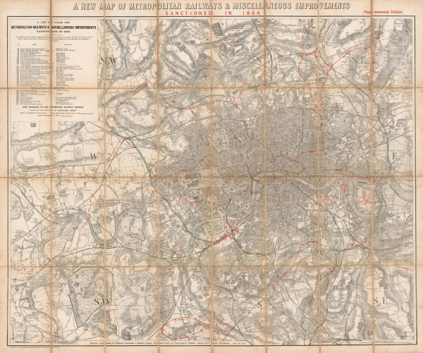
Edward Stanford, A New Map of Metropolitan Railways Sanctioned in 1864, 1864£ 875.00
-
Edward Stanford, Railway Map of the British Isles, 1866£ 385.00
-
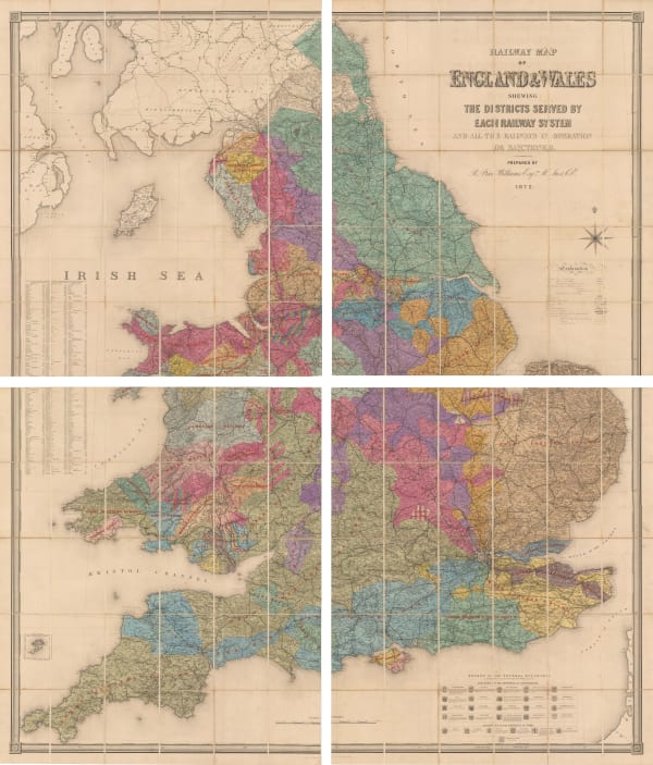
Railway Map of the England and Wales Shewing the Districts Served by Each Railway System, 1872Edward StanfordSeries: LondonEdward Stanford, Railway Map of the England and Wales Shewing the Districts Served by Each Railway System, 1872£ 3,950.00
-
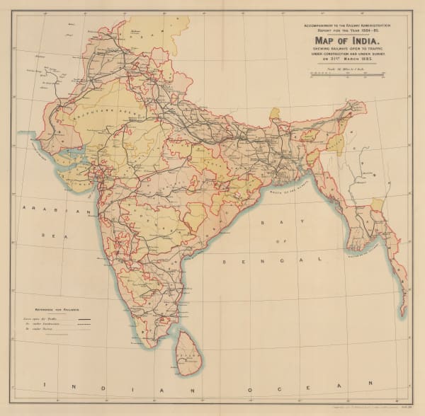
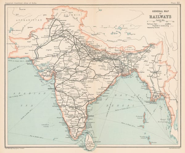
Map of India shewing Railways open to traffic, under construction and under survey onm 31st March 1885, 1885Survey of IndiaSeries: LondonSurvey of India, Map of India shewing Railways open to traffic, under construction and under survey onm 31st March 1885, 1885£ 585.00
-
W.J. Adams & Sons, The "District Railway" Map of London - Jubilee Edition, 1887£ 1,050 (framed)
-
W. & A.K. Johnston, Railway Map of England and Wales, 1895£ 795.00
-
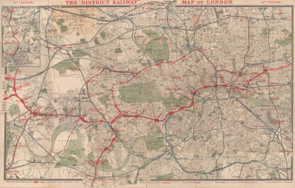
The "District Railway" Map of London - 6th Edition, 1898Sampson Low, Marston & CompanySeries: LondonSampson Low, Marston & Company, The "District Railway" Map of London - 6th Edition, 1898£ 700.00
-
George Philip, Map of the Eastern Indian Railway, 1900 c.£ 385.00
-
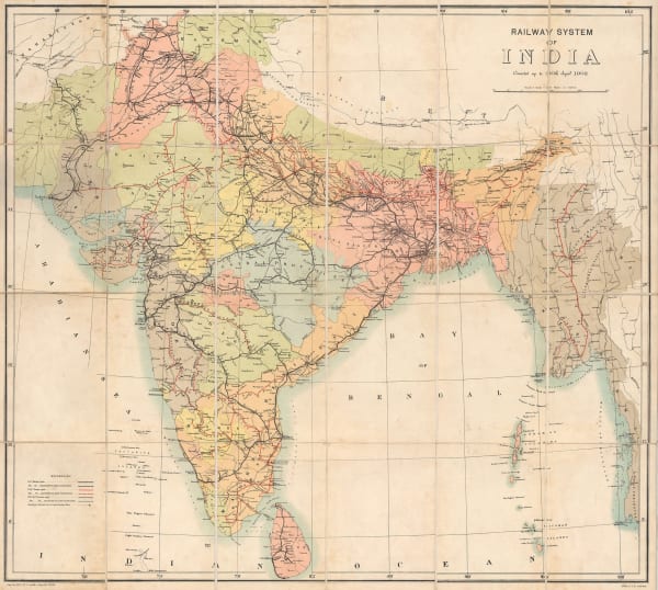
Survey of India, Railway System of India, 1902£ 585.00
-
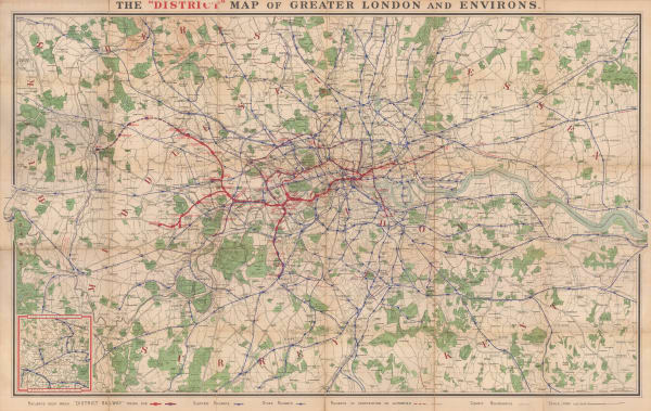
The "District Map" of Greater London and Environs - 1st Edition, 1902Sampson Low, Marston & CompanySeries: LondonSampson Low, Marston & Company, The "District Map" of Greater London and Environs - 1st Edition, 1902£ 400.00
-
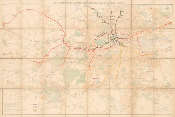
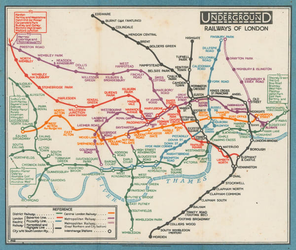
The Underground Electric Railways of London, 1904Underground Electric Railways Company of London (UERL)Series: LondonUnderground Electric Railways Company of London (UERL), The Underground Electric Railways of London, 1904£ 2,800 (framed)
-
George Philip & Son Ltd., Perrier Motor Map of Scotland, 1906£ 400.00
-
George Philip & Son Ltd., Perrier Motor Map of England & Wales, 1906 (c.)£ 295.00
-
Railway Clearing House, Official Railway Map of London and its Environs, 1907£ 550.00
-
John Bartholomew & Co., Railways of Northeast India & Bengal, 1909£ 125.00
-
John Bartholomew & Co., Railway Map of India, 1909£ 68.00
-
John Bartholomew & Co., Railways of South India & Sri Lanka, 1909£ 95.00
-
Pearson's Cycling, Motoring, and Traveller's Road Map of 50 Miles around Sydney, 1910 c.Joseph PearsonSeries: SydneyJoseph Pearson, Pearson's Cycling, Motoring, and Traveller's Road Map of 50 Miles around Sydney, 1910 c.£ 395.00
-
Joseph Pearson, Road Map of 50 Miles around Sydney, 1910 c.£ 395.00
-
Russian schematic map of the Ussuriysk, Manchurian, and Korean Railroads, 1910 c.G. De KelschSeries: St. PetersburgG. De Kelsch, Russian schematic map of the Ussuriysk, Manchurian, and Korean Railroads, 1910 c.£ 525.00
-
Central Argentine Railways, Map of the Argentine Railways, 1911£ 900.00
-
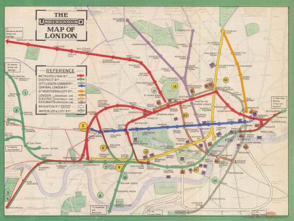
London Underground, The Underground Map of London, 1911£ 950.00
-
-
London Underground, London Underground Railways, 1912£ 950 (framed)
-
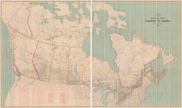
Edward Stanford, Railway Map of the US & Canada, 1913£ 1,450.00
-
Royal Geographical Society (RGS), Railway map of Africa, 1916£ 485.00
-
London Underground, Underground Map of London with some Motor Bus Extensions, 1916£ 625 (framed)
-
Edward Stanford, Trans-Siberian Railway, 1917£ 1,250.00
-
Railway Clearing House, Official Railway Map of the West of England, 1918£ 395.00
-
Africa showing British possessions at their height, 1920Royal Geographical Society (RGS)Series: LondonRoyal Geographical Society (RGS), Africa showing British possessions at their height, 1920£ 345.00
-
Relief Map of the Territory Served by the Lines of the Pacific Electric Railway in Southern California, 1920O.A. SmithO.A. Smith, Relief Map of the Territory Served by the Lines of the Pacific Electric Railway in Southern California, 1920£ 950.00
-
Waterlow & Sons, Railway Map of Argentina, 1921£ 1,350.00
-
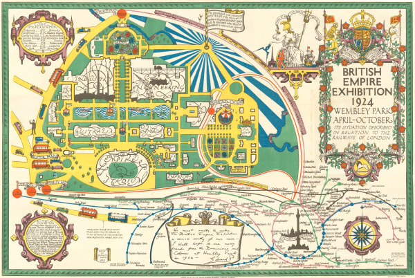
Kennedy North, British Empire Exhibition 1924, 1923£ 650.00
-
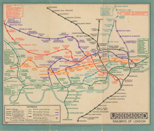
Macdonald Gill, Map of the Underground Railways of London, 1923£ 1,650 (framed)
-
Waterlow & Sons, Underground Map of London, 1924£ 750.00
-
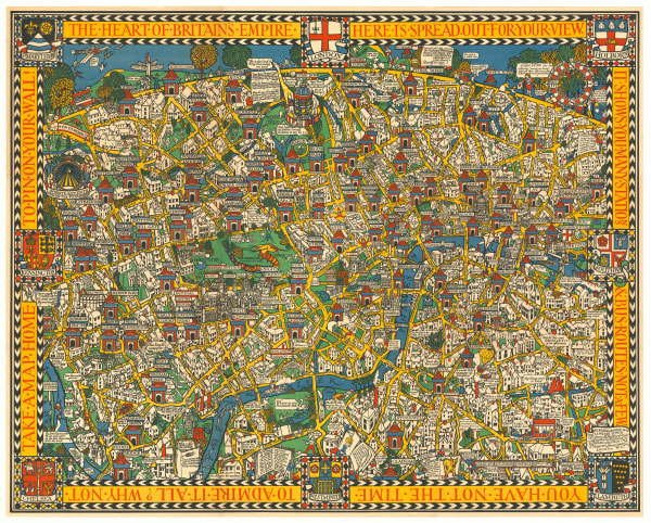
Macdonald Gill, The Wonderground Map of London, 1924 c.£ 4,800 (framed)
-
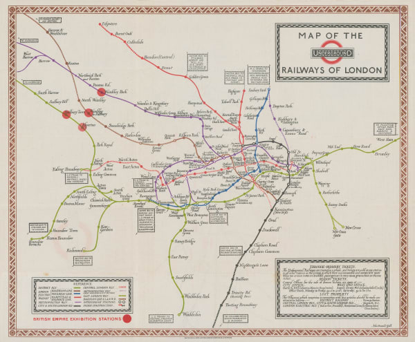
Fred H. Stingemore, Map of London's Underground Railways, 1927£ 795.00
-
-
Railway Clearing House, Cardiff, 1928£ 55.00
-
Fred H. Stingemore, Map of London's Underground Railways, 1929£ 795.00
-
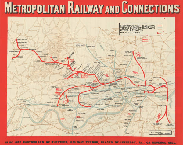
London Underground, Metropolitan Railway and Connections, 1930 (c.)£ 550.00
-
Fred H. Stingemore, Map of London's Underground Railways, 1931£ 795.00
-
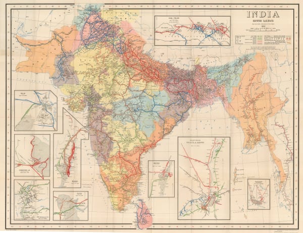
Survey of India, India Showing Railways, 1932£ 475.00
-
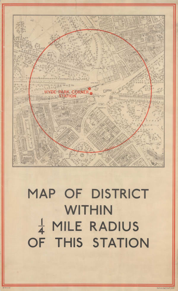
Edward Stanford, Hyde Park Corner Tube Station and 1/4 Miles Around, 1932£ 1,250.00
-
-
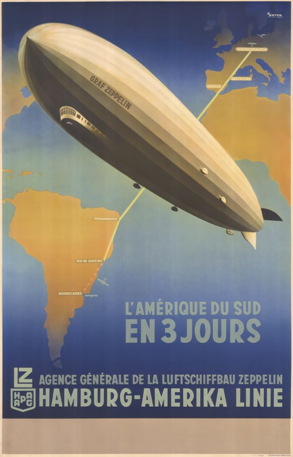
Air France, Air France - 'Reseau Aerien Mondial', 1934£ 3,500.00
-
Clifford & Rosemary Ellis, Christmas Shopping by Underground Poster, 1935£ 4,000 (framed)
-
-
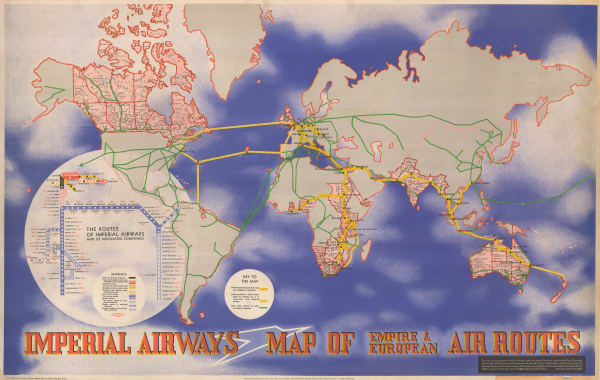
Imperial Airways, Map of the Empire and European Air Routes, 1936£ 3,000 (framed)
-
-
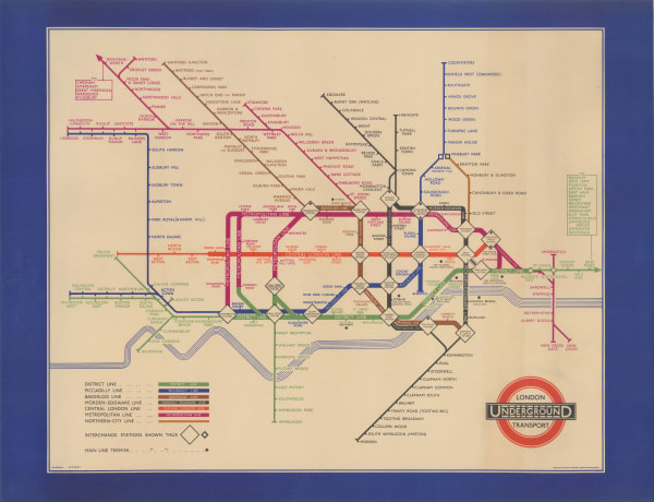
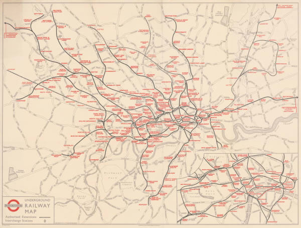
London Transport, Underground Railway Map, 1937£ 450.00
-
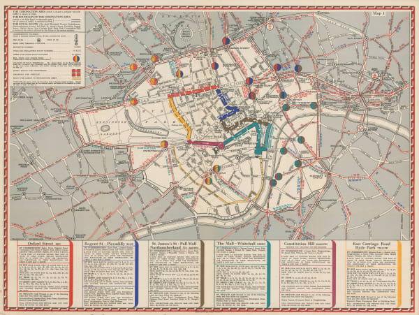
Geographia Ltd., The Coronation Area, 1937£ 450 (framed)
-
Air France, Air France 'Reseau Aerien Mondial', 1937 c.£ 4,500.00
-
J.G. Bartholomew, Environs of Paris: Rail and Automobile Routes, 1938£ 28.00
-
Flying Magazine, The Empire Air Mail Scheme, 1938 c.£ 265.00
-
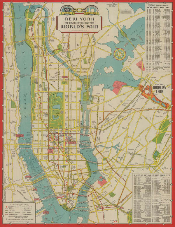
Hagstrom Co. Inc., New York and Routes to the New York World's Fair, 1939£ 325.00
-
London Underground, Bakerloo Line Extension, 1939£ 225.00
-
The Seamen's Bank for Savings: Rapid Transit map of Greater New York, 1943General Drafting Co.Series: New YorkGeneral Drafting Co., The Seamen's Bank for Savings: Rapid Transit map of Greater New York, 1943£ 325.00
-
-
Air France, Air France Postcard - 'Amerique du Nord', 1946 c.£ 250.00
-
Air France, Air France - Orient Extreme-Orient, 1947£ 4,750 (framed)
-
Air France, Air France Postcard - Paris, 1947 (c.)£ 250.00
-
Air France, Air France Postcard - Extréme Orient, 1949 c.£ 250 (framed)
-
Air France, Air France Celestial Planisphere, 1950£ 4,000.00
-
-
Air France, Air France Postcard - 'Amérique du Sud', 1950 c.£ 250.00
-
Air France, Air France - L'Amerique du Nord, 1951£ 3,500.00
-
Lucien Boucher, Air France - Great Britain, 1952£ 3,500.00
-
Air France, Air France Route Map, 1952 c£ 4,250.00
-
Geographia Ltd., Queen Elizabeth II's Coronation Route, 1953£ 495.00
-
Charles Edward Turner, Cunard - UK to USA, 1954£ 3,500.00
-
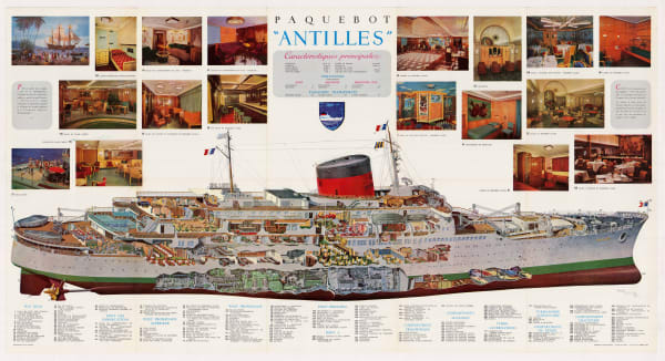
Michel Lezla, Compagnie Generale Transatlantique - Paquebot Antilles, 1955£ 1,800.00


Page
1
of 2