-

-
Comparative View of the Mountains, Rivers & Waterfalls of the World, 1839 c.Charles V. MoninSeries: Paris & LyonCharles V. Monin, Comparative View of the Mountains, Rivers & Waterfalls of the World, 1839 c.£ 1,750.00
-
Compartative View of the Principal Mountains and Rivers in the World, 1840 c.Sidney HallSeries: LondonSidney Hall, Compartative View of the Principal Mountains and Rivers in the World, 1840 c.£ 475.00
-
Charles V. Monin, Tableau Comparatif de la Hauteur des Montagnes, 1840 c.£ 475.00
-
A Map of the Principal Rivers shewing their Courses, Countries, and Comparative Lengths, 1844Society for the Diffusion of Useful Knowledge (SDUK)Series: LondonSociety for the Diffusion of Useful Knowledge (SDUK), A Map of the Principal Rivers shewing their Courses, Countries, and Comparative Lengths, 1844£ 195.00
-
Ashford & Loader, The Heights of the Mountains of the Eastern Hemisphere, 1845£ 975.00
-
James Reynolds, Waterfalls, 1846 c.£ 545.00
-
W. & A.K. Johnston, Zoological Geography - Ruminants & Rodents, 1848£ 595.00
-
W. & A.K. Johnston, Zoological Geography - Monkeys, Marsupials & Pachyderms, 1848£ 595.00
-
W. & A.K. Johnston, Zoological Geography - Carnivores, 1848£ 595.00
-
W. & A.K. Johnston, Zoological Geography - Birds, 1848£ 595.00
-
W. & A.K. Johnston, Botanical Geography - Food Crops & Edible Plants, 1848£ 495.00
-
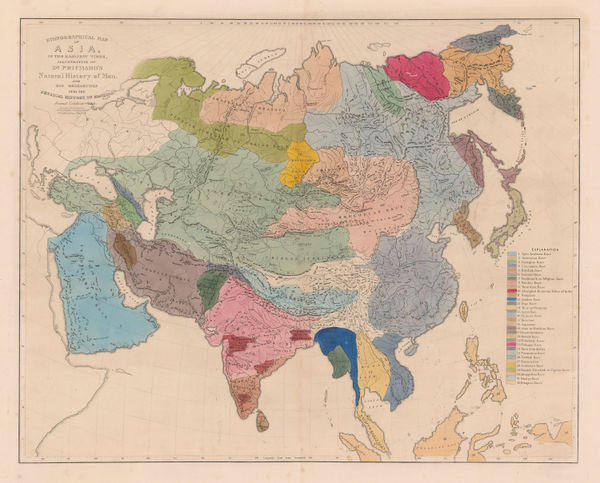
James Cowles Prichard, Ethnographic Map of Asia, 1861£ 550.00
-
James Cowles Prichard, Ethnographic Map of South America, 1861£ 450.00
-
James Cowles Prichard, Ethnographic Map of North America, 1861£ 550.00
-
Justus Perthes, Bubonic Plague Outbreaks from 1346 to 1879, 1879£ 325.00
-
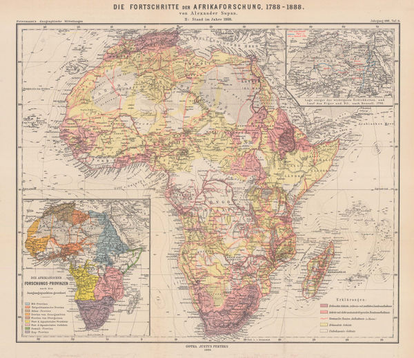
Justus Perthes, The Progress of African Exploration, 1888£ 245.00
-
Henry William Blair, New York City's Drinking Problem, 1888£ 1,250.00
-
Charles Booth, First Edition Poverty Map of the East End, 1889£ 4,500.00
-
Charles Booth, Charles Booth's Poverty Map of London (NE), 1889£ 3,750.00
-
Charles Booth, Charles Booth's Poverty Map of London (NW), 1889£ 3,750.00
-
-
Charles Booth, Putney & Wandsworth Poverty Map, 1890 c.£ 450.00
-
The General Election 1892 & The Graphic Parliamentary Map [Sold as a Pair], 1892The Graphic MagazineSeries: LondonThe Graphic Magazine, The General Election 1892 & The Graphic Parliamentary Map [Sold as a Pair], 1892£ 950.00
-
Charles Booth, Battersea & Clapham Poverty Map, 1900£ 1,650.00
-
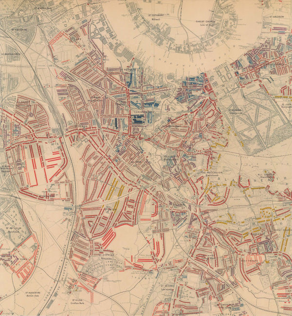
Charles Booth, Poverty Map of Greenwich, Deptford & Lewisham, 1900£ 1,275.00
-
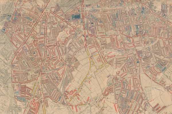
Charles Booth, Poverty Map of Stoke Newington, Dalston, Haggerston & Hackney, 1900£ 795.00
-
Map Showing Places of Religious Worship, Public Elementary Schools, and Houses Licensed for the Sale of Intoxicating Drinks, 1900Charles BoothSeries: LondonCharles Booth, Map Showing Places of Religious Worship, Public Elementary Schools, and Houses Licensed for the Sale of Intoxicating Drinks, 1900£ 2,950.00
-
Charles Booth, Poverty Map of Bow, Poplar, Stepney & Limehouse, 1900£ 745.00
-
Charles Booth, Poverty Map of Peckham, Brixton & Camberwell, 1900£ 1,250.00
-
Charles Booth, Poverty Map of Notting Hill, Hammersmith & West Kensington, 1900£ 1,650.00
-
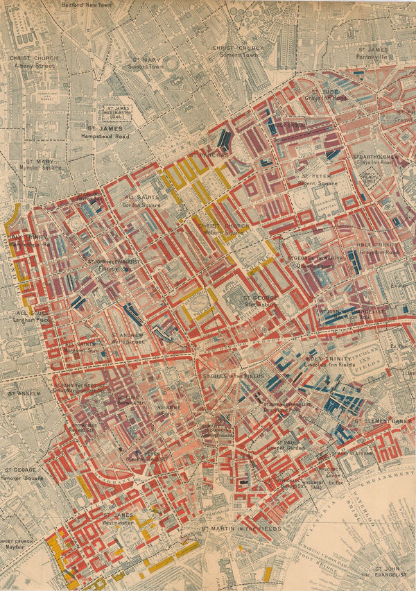
Charles Booth, West Central London, 1900£ 925.00
-
Charles Booth, Poverty Map of Hampstead and St. John's Wood, 1900 c.£ 1,350.00
-
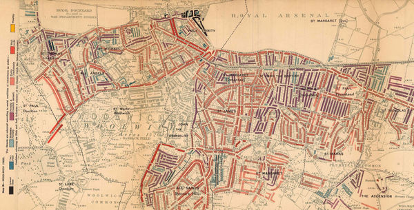
Charles Booth, Poverty Map of Woolwich & Plumstead, 1902£ 325.00
-
George W. Bacon, Bacon's Chart of Useful Knowledge, 1910 c.£ 3,600.00
-
John Bartholomew & Son, World Map of Vegetation and Ocean Currents, 1922£ 175.00
-
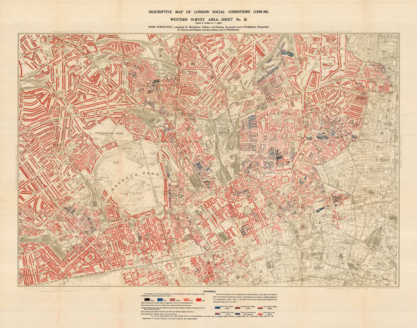
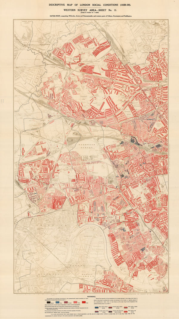
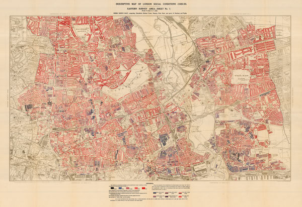
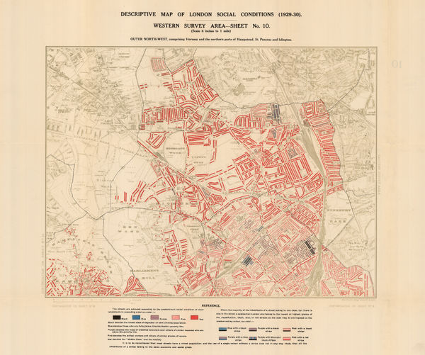
Charles Booth, Descriptive Map of London Social Conditions (1929-1930), 1930£ 1,950.00
-
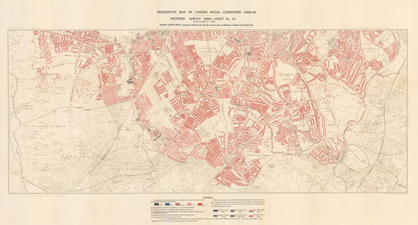
Charles Booth, Descriptive Map of London Social Conditions (1929-1930), 1930£ 1,550.00
-
Charles Booth, Poverty Map of Whitechapel, Hackney, Shoreditch & Stratford, 1930£ 1,350.00
-
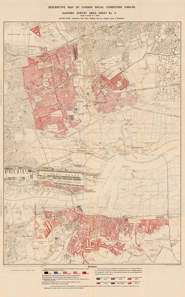
Charles Booth, Descriptive Map of London Social Conditions (1929-1930), 1930£ 950.00
-
Charles Booth, Poverty Map of Wandsworth, Streatham, Tooting, Clapham & Dulwich, 1930£ 1,450.00
-
Charles Booth, Poverty Map of Royal Docks, Barking & Woolwich, 1930£ 650.00
-
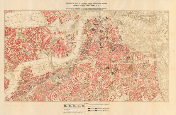
Charles Booth, Descriptive Map of London Social Conditions (1929-1930), 1930£ 2,500.00
-
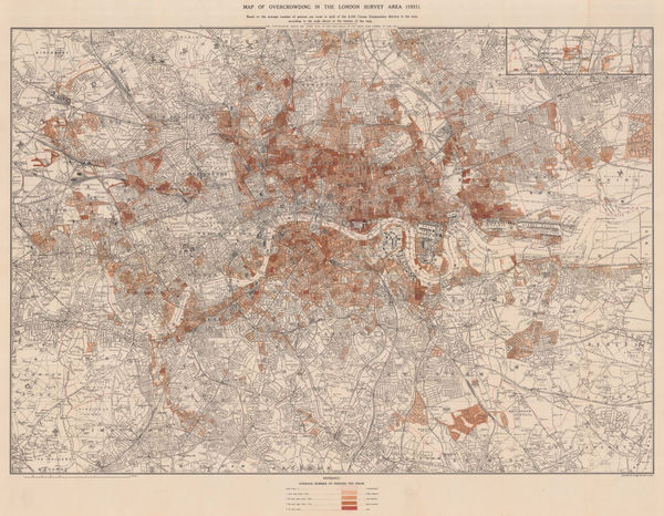
Charles Booth, Map of Overcrowding in the London Survey Area (1931), 1931£ 1,950.00
-
Wolodymyr Kubijowytsch, Ethnographic Map of Ukraine, 1938£ 1,500.00
-
Louis Larmat, Infographic Chart of Champagne Production & Quality from 1844-1943, 1944£ 450.00
-
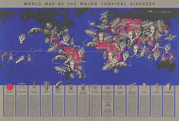
Boris Artzybasheff, World Map of the Major Tropical Diseases, 1944£ 525.00
-
Harrap & Co., Ltd., Soviet Propaganda - USSR Agriculture and Fur-Bearing Animals, 1946£ 295.00
-
Harrap & Co., Ltd., Soviet Propaganda - USSR Industries and Mineral Deposits, 1946£ 395.00
-
Pict. Charts Service, USA and the World Today, 1949£ 695.00
Infographics
Our entire inventory of over 10,000 antique and vintage maps is now available to browse by region, date, cartographer, and subject


![The Graphic Magazine, The General Election 1892 & The Graphic Parliamentary Map [Sold as a Pair], 1892](https://static-assets.artlogic.net/w_600,c_limit,f_auto,fl_lossy,q_auto/artlogicstorage/themaphouse/images/view/482cbe78e7901f3a280f8da45f96c026j/themaphouse-the-graphic-magazine-the-general-election-1892-the-graphic-parliamentary-map-sold-as-a-pair-1892.jpg)