-
 John Cowley, An Improved Map of Cardigan Shire, 1744£ 75.00
 -
John Cowley, An Improved Map of Carnarvan Shire, 1744£ 80.00
-
John Cowley, An Improved Map of Flintshire, 1744£ 70.00
-
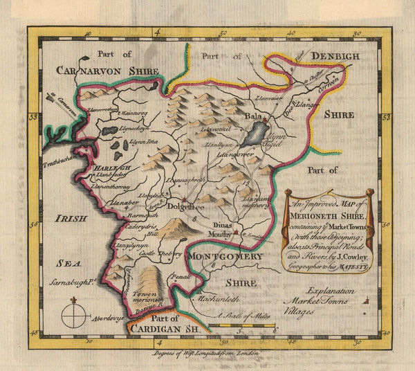
John Cowley, An Improved Map of Merioneth Shire, 1744£ 80.00
-
John Cowley, An Improved Map of Monmouthshire, 1744£ 90.00
-
John Cowley, An Improved Map of Radnorshire, 1744£ 65.00
-
Emanuel Bowen & Thomas Kitchin, Glamorgan, 1754£ 395.00
-
Emanuel Bowen & Thomas Kitchin, Carmarthenshire, 1754£ 265.00
-
Thomas Kitchin, An Accurate Map of Pembroke Shire, 1760 c.£ 395.00
-
Emanuel Bowen & Thomas Kitchin, An Accurate Map of Radnorshire, 1760 c.£ 295.00
-
Thomas Kitchin, Cardigan Shire, 1760 c.£ 375.00
-
T. & E. Bowen, An Accurate Map of Brecknock Shire, 1763£ 225.00
-
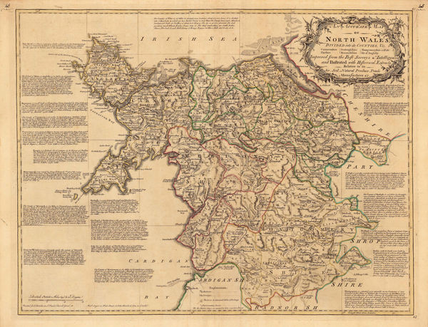
T. & E. Bowen, An Accurate Map of North Wales, 1763£ 495.00
-
Emanuel Bowen, An Accurate Map of the County of Monmouth, 1777£ 295.00
-
T. & E. Bowen, Monmouthshire - Divided into Hundreds, 1777£ 150.00
-
Carington Bowles, Bowles's New Medium Map of Monmouth Shire, 1785£ 95.00
-
Capt. Greenvile Collins, Milford-Haven, 1785£ 395.00
-
Franz Von Reilly, Das Furstenthum Wales, 1789£ 185.00
-
John Cary, A Map of South Wales, 1805£ 165.00
-
Cole & Roper, Anglesey, 1807£ 55.00
-
Cole & Roper, Flintshire, 1807£ 55.00
-
Cole & Roper, Brecknockshire, 1809£ 55.00
-
Cole & Roper, Cardiganshire, 1809£ 55.00
-
Cole & Roper, Merionethshire, 1809£ 55.00
-
John Cary, Monmouthshire, 1809£ 55.00
-
Cole & Roper, Montgomeryshire, 1809£ 55.00
-
John Cary, Wales, 1809£ 1,250.00
-
Langley & Belch, Langley's New Map of Brecknockshire, 1818£ 75.00
-
Langley & Belch, Langley's New Map of Carnarvonshire, 1818£ 75.00
-
Langley & Belch, Langley's New Map of Denbighshire, 1818£ 65.00
-
Langley & Belch, Langley's New Map of Merionethshire, 1818£ 65.00
-
Langley & Belch, Langley's New Map of Montgomeryshire, 1818£ 80.00
-
Glamorgan, Brecknockshire (Powys) and Radnorshire (Powys), 1828Christopher & John GreenwoodSeries: LondonChristopher & John Greenwood, Glamorgan, Brecknockshire (Powys) and Radnorshire (Powys), 1828£ 1,250.00
-
James Pigot, Monmouthshire, 1830 c.£ 88.00
-
Christopher & John Greenwood, Map of the County of Monmouth, 1831£ 385.00
-
Christopher & John Greenwood, Glamorgan, Brecon & Radnor, 1831£ 360.00
-
Robert Kearsley Dawson, Pembroke, 1832£ 55.00
-
Map of the North West Circuit of The Principality of Wales, 1834Christopher & John GreenwoodSeries: LondonChristopher & John Greenwood, Map of the North West Circuit of The Principality of Wales, 1834£ 385.00
-
Joshua Archer, Flintshire, 1840 c.£ 30.00
-
Thomas Moule, Monmouthshire, 1840 c.£ 82.00
-
J. & C. Walker, Monmouthshire, 1845£ 44.00
-
Samuel Lewis, Cardiganshire, 1858£ 32.00
-
Samuel Lewis, Carnarvonshire, 1858£ 32.00
-
Samuel Lewis, Flintshire, 1858£ 28.00
-
Aleph, Wales, 1869£ 1,350.00
-
H. B. Biden, Snowdonia, 1877 c£ 450.00
-
George W. Bacon, Cycling and Motoring Map of Cardiff District, 1910 c£ 95.00
-
George W. Bacon, Cardiff, Penarth & Llandaff, 1920 c.£ 295.00
-
Railway Clearing House, Cardiff, 1928£ 55.00
-
Automobile Association (AA), Cardiff, 1934£ 125.00
-
Littlebury & Co. Ltd., Cardiff, 1955 (c.)£ 150.00


Page
2
of 2