-
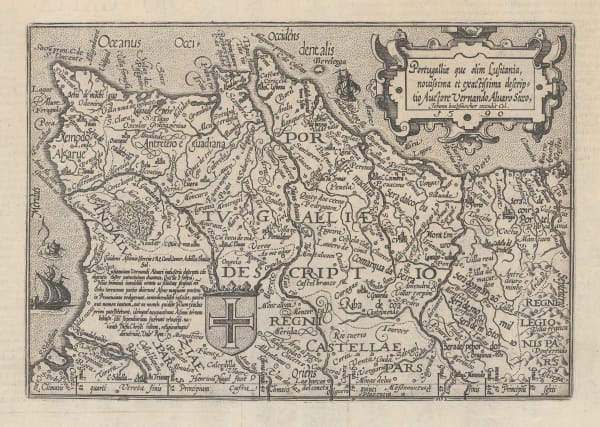
 Martin Waldseemüller & Laurent Fries, Early Woodcut Map of Spain & Portugal, 1541£ 2,850.00
 -
Claudius Ptolemy & Laurent Fries, Ptolemaic Map of Spain & Portugal, 1541£ 2,150.00
-
Sebastian Münster, Spain & Portugal, 1558£ 495.00
-
Georg Braun & Frans Hogenberg, Toledo & Valladolid, 1575£ 1,650.00
-
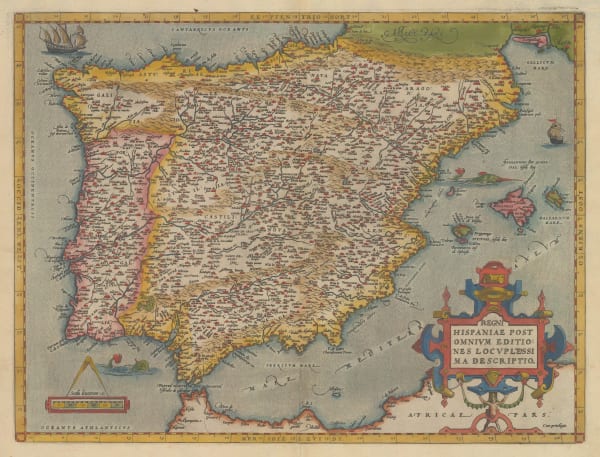
Abraham Ortelius, Spain and Portugal, 1584£ 950.00
-
Lucas Waghenaer, Sea Chart of the Algarve, 1584 c.£ 1,100.00
-
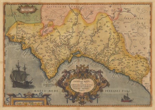
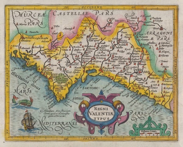
Abraham Ortelius, Kingdom of Valencia, 1592£ 925.00
-
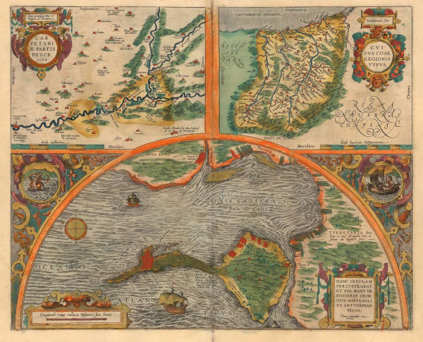
Abraham Ortelius, Cadiz, Toledo & Gipuzkoa (Basque Country), 1592£ 985.00
-
-
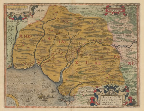
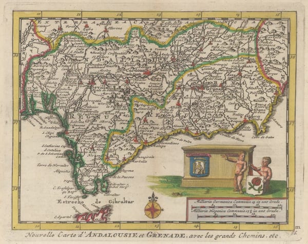
Abraham Ortelius, Andalucia & Seville, 1598£ 1,350.00
-
Matthias Quad, Portugal, 1609£ 425.00
-
Tomaso Porcacchi, Menorca (Minorca), 1620£ 475.00
-
Mercator Hondius, Kingdom of Valencia, 1620 c.£ 425.00
-
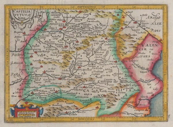
Mercator Hondius, Castile-León, 1628£ 185.00
-
Mercator Hondius, Asturias, Cantabria, Vizcaya, Guipuzcoa & Navarra., 1634£ 345.00
-
Mercator Hondius, Aragon & Catalunya (Catalonia), 1635£ 165.00
-
Mercator Hondius, Kingdom of Valencia, 1635£ 225.00
-
Mercator Hondius, Castile-León, 1635£ 185.00
-
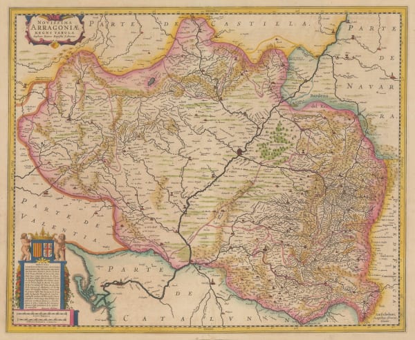
Jodocus & Henricus Hondius, Kingdom of Aragon, 1636£ 495.00
-
Willem & Jan Blaeu, Kingdom of Aragon, 1640 c.£ 600.00
-
Willem & Jan Blaeu, Kingdom of Galicia, 1640 c.£ 695.00
-
Matthäus Merian, Spain & Portugal, 1640 c.£ 495.00
-
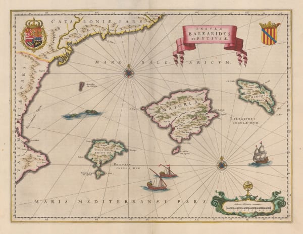
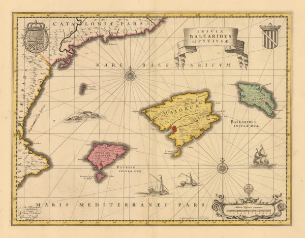
Willem & Jan Blaeu, Mallorca, Menorca & Ibiza, 1640 c.£ 1,850.00
-
Willem & Jan Blaeu, Andalucía, 1640 c.£ 750.00
-
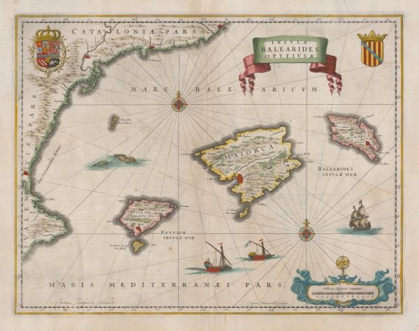
Jan Jansson, Balearic Islands, 1650 (c.)£ 1,350.00
-
Jan Blaeu, Aragon & Navarra, 1650 c.£ 465.00
-
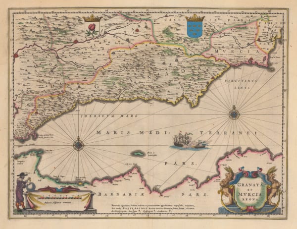
Willem & Jan Blaeu, Granada, Murcia and Barbary Coast, 1650 c.£ 685.00
-
Willem & Jan Blaeu, Portugal showing the Kingdom of Algarve, 1650 c.£ 1,150.00
-
Willem & Jan Blaeu, Kingdom of Valencia, 1650 c.£ 550.00
-
Willem & Jan Blaeu, Castille, 1650 c.£ 495.00
-
-
Jan Jansson, Granada and Murcia, 1666£ 645.00
-
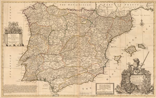
John Speed, Spain and Portugal, 1676£ 1,950.00
-
Nicolas Sanson, Iberian Peninsula, 1679£ 195.00
-
Frederick De Wit, Dutch Golden Age map of Catalonia, 1680 c.£ 825.00
-
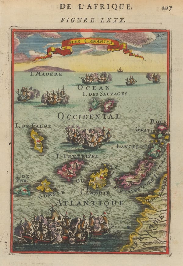
Alain Manesson Mallet, Early miniature map of the Canary Islands, 1683£ 225.00
-
Robert Morden, Canary Islands and Madeira, 1688£ 285.00
-
Robert Morden, Rare miniature map of the Azores, 1688£ 225.00
-
Cornelis & Justus Danckerts, Spain and Portugal, 1690 c.£ 695.00
-
Frederick De Wit, Spain and Portugal, 1690 c.£ 800.00
-
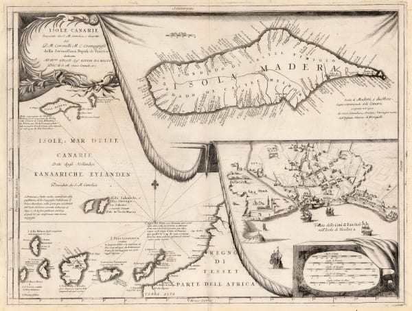
Vincenzo Coronelli, Madeira and view of Funchal, 1690 c.£ 695.00
-
Vincenzo Coronelli, Early map of Mallorca, 1692£ 985.00
-
Giovanni Giacomo Rossi, Two sheet map of Portugal, 1692£ 1,250.00
-
Alexis-Hubert Jaillot, Portugal with the Kingdom of the Algarves., 1695£ 1,500.00
-
Vincenzo Coronelli, Chart of the Straits of Gibraltar , 1696£ 445.00
-
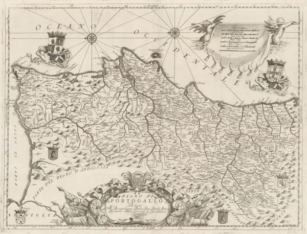
Vincenzo Coronelli, Portugal, 1696£ 995.00
-
Pierre Mortier, Chart the Azores, 1700£ 1,500.00
-
Johannes van Keulen, Chart of the Balearic Islands and Spanish coast, 1700 c.£ 2,350.00
-
Nicolas & Guillaume Sanson, The Canary Islands, 1705£ 545.00
-
Nicolas de Fer, Galicia, 1705£ 395.00
-
Nicolas de Fer, Portugal, 1705£ 350.00
-
Nicolas de Fer, Straits of Gibraltar, 1705£ 495.00
-
Nicolas de Fer, Northeast Spain, 1705£ 285.00
-
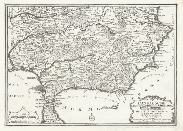
Nicolas de Fer, Southern Spain & Gibraltar , 1705£ 285.00
-
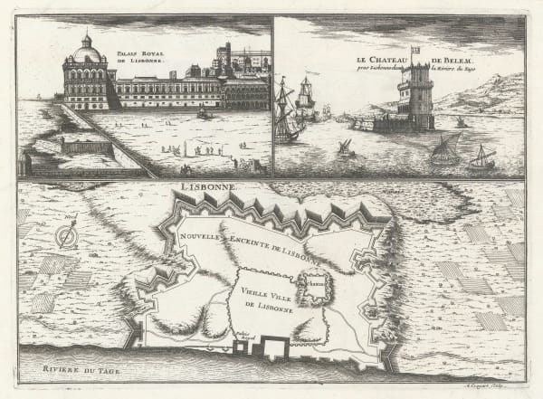
Nicolas de Fer, Lisbon, 1705£ 495.00
-
Pierre Mortier, Chart of the coast of Portugal and Gibraltar, 1708£ 1,400.00
-
Pierre Mortier, Chart of the north coast of Spain, 1708£ 785.00
-
Valk & Schenk, The Balearic Islands, 1710 c.£ 1,350.00
-
Gerhard Valk, Andalucia and southern Portugal, 1710 c.£ 525.00
-
Herman Moll, Large map of Spain and Portugal, 1711£ 2,750.00
-
Pieter van der Aa, Chart of the Canary Islands and Madeira, 1714£ 495.00
-
Pieter van der Aa, Spain and Portugal, 1714£ 395.00
-
Pieter van der Aa, Bay of Cadiz, 1715£ 145.00
-
Pieter van der Aa, Andalucia and Granada, 1715£ 195.00
-
Pieter van der Aa, Castile region, 1715£ 195.00
-
Alain Manesson Mallet, Cadiz, 1719£ 120.00
-
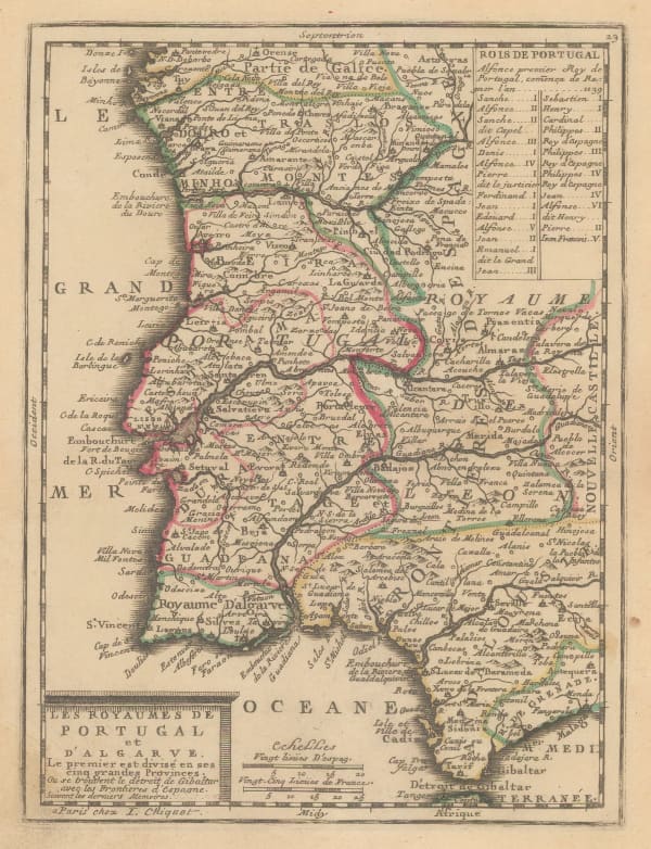
Jacques Chiquet, Portugal, Southwest Spain and Gibraltar, 1719£ 245.00
-
Johann Baptist Homann, Decorative plan of Madrid, 1720 c.£ 1,850.00
-
Herman Moll, Spain and Portugal, 1720 c.£ 150.00
-
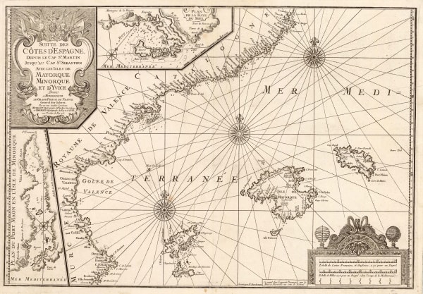
Rare sea chart of the Balearic Islands and Spanish coasr, 1723Henri Michelot and Laurent BrémondSeries: MarseillesHenri Michelot and Laurent Brémond, Rare sea chart of the Balearic Islands and Spanish coasr, 1723£ 4,250.00
-
Henri Michelot and Laurent Brémond, Western Mediterranean Sea Chart, 1726£ 2,650.00
-
Guillaume Danet, Gibraltar and Ceuta, 1727£ 525.00
-
Matthaus Seutter, City plan and panorama of Barcelona, 1730 c.£ 2,250.00
-
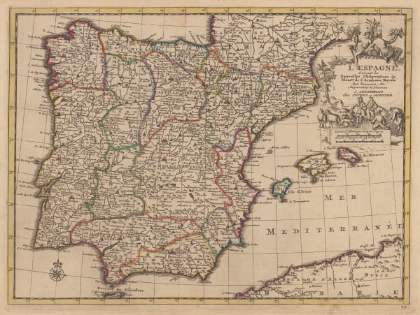
Spain, Portugal and the Balearic Islands, 1730 c.Covens (Jean) & Mortier (Cornelius)Series: AmsterdamCovens (Jean) & Mortier (Cornelius), Spain, Portugal and the Balearic Islands, 1730 c.£ 285.00
-
Covens (Jean) & Mortier (Cornelius), Portugal, 1730 c.£ 155.00
-
Spain, Portugal and the Balearic Islands, 1730 c.Covens (Jean) & Mortier (Cornelius)Series: AmsterdamCovens (Jean) & Mortier (Cornelius), Spain, Portugal and the Balearic Islands, 1730 c.£ 385.00
-
Covens (Jean) & Mortier (Cornelius), Spain and Portugal, 1730 c.£ 650.00
-
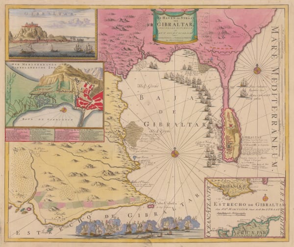
Covens (Jean) & Mortier (Cornelius), Gibraltar, 1730 c.£ 925.00
-
Jean Baptiste Nolin, Spain and Portugal, 1740£ 750.00
-
Jacques-Nicolas Bellin, Mallorca, Menorca & Ibiza, 1740£ 1,850.00


Page
1
of 4