-
 Georg Braun & Frans Hogenberg, Frankfurt, 1572£ 2,200.00
 -
-
Georg Braun & Frans Hogenberg, Vienna & Budapest, 1572£ 1,200.00
-
Abraham Ortelius, Cyprus, 1598£ 2,850.00
-
Matthäus Merian, Rome, 1640 c.£ 2,750.00
-
Alain Manesson Mallet, Corfu, 1719£ 295.00
-
Jacques Begnine Bossuet, Mappe-Monde ou Carte Generale du Globe Terrestre, 1722£ 375.00
-
Matthaus Seutter, Brussels (Bruxelles), 1745 c.£ 2,450.00
-
Jacques-Nicolas Bellin, Plan of Beijing (Peking), 1748£ 225.00
-
William Guthrie, Chart of the World, 1785 c£ 275.00
-
John Stockdale, Venice, 1800£ 375.00
-
Conrad Malte-Brun, Mappe-Monde sur la Projection Reduite de Mercator, 1812£ 195.00
-
-
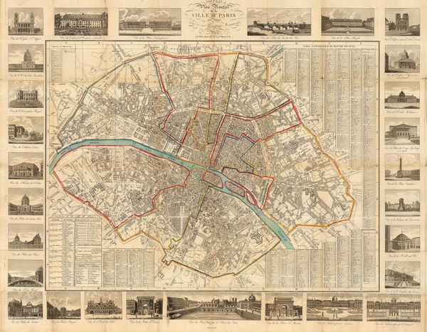
Seguin, Paris, 1825£ 895.00
-
John Crawfurd, Early map of Bangkok, 1828£ 445.00
-
Society for the Diffusion of Useful Knowledge (SDUK), Rome, 1830£ 195.00
-
Thomas Starling, The World, 1830£ 295.00
-
Anonymous, Chart of the World, 1830 c£ 185.00
-
Society for the Diffusion of Useful Knowledge (SDUK), Istanbul (Constantinople), 1840£ 485.00
-
Geographical Diagram of the Earth Adapted for Illustrating its Movements &c., 1840 c.James ReynoldsSeries: LondonJames Reynolds, Geographical Diagram of the Earth Adapted for Illustrating its Movements &c., 1840 c.£ 275.00
-
Joseph Meyer, New York City, 1844£ 845.00
-
Society for the Diffusion of Useful Knowledge (SDUK), Lisbon, 1844£ 495.00
-
Society for the Diffusion of Useful Knowledge (SDUK), Porto, 1844£ 475.00
-
A Map of the Principal Rivers shewing their Courses, Countries, and Comparative Lengths, 1844Society for the Diffusion of Useful Knowledge (SDUK)Series: LondonSociety for the Diffusion of Useful Knowledge (SDUK), A Map of the Principal Rivers shewing their Courses, Countries, and Comparative Lengths, 1844£ 195.00
-
Joseph Meyer, Naples, 1845£ 495.00
-
Luigi Brocktorff, Valletta, Malta, 1845 (c.)£ 1,250.00
-
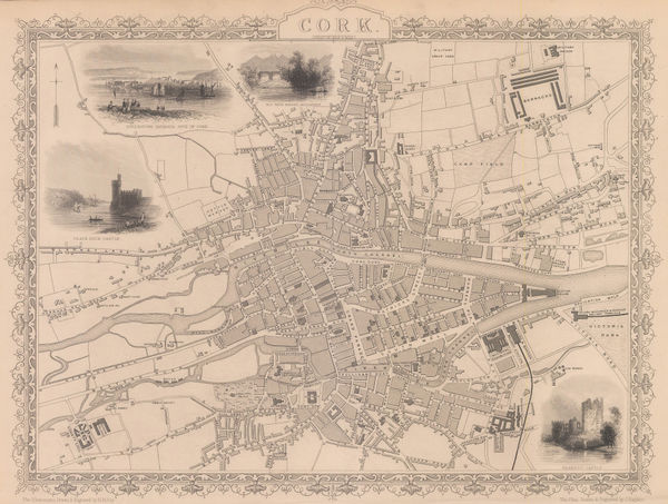
John Tallis, Cork, 1851£ 375.00
-
W. & A.K. Johnston, The Crop Distribution of the World, 1855£ 375.00
-
G. C. Castellini, Monaco, 1860£ 1,450.00
-
Aime Humbert, Tokyo, 1870£ 645.00
-
O.W. Gray & Son, New Map of the World in Hemispheres, 1881£ 495.00
-
George Bradshaw, Vienna, 1889£ 225.00
-
George Philip & Son Ltd., 4-Inch Philips' Graphic Globe, 1890 (c.)£ 1,250.00
-
J.G. Bartholomew, Plan of Paris, 1893£ 115.00
-
J.G. Bartholomew, Munich, 1893£ 68.00
-
Anonymous, Tokyo, 1895£ 2,550.00
-
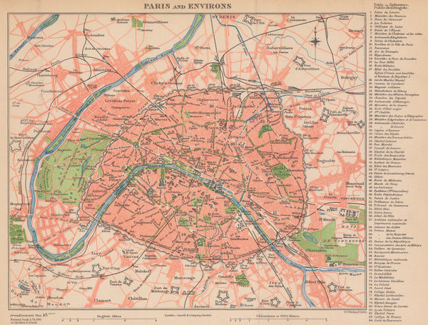
Cassell & Co., Paris and Environs, 1895 (c.)£ 78.00
-
Karl Baedeker, Malaga, 1901£ 58.00
-
Rand, McNally & Co., Rand McNally & Co's Map of the World, 1901£ 985.00
-
Royal Geographical Society (RGS), Capri & Pozzuoli, 1903£ 115.00
-
George Bradshaw, Budapest, 1904£ 325.00
-
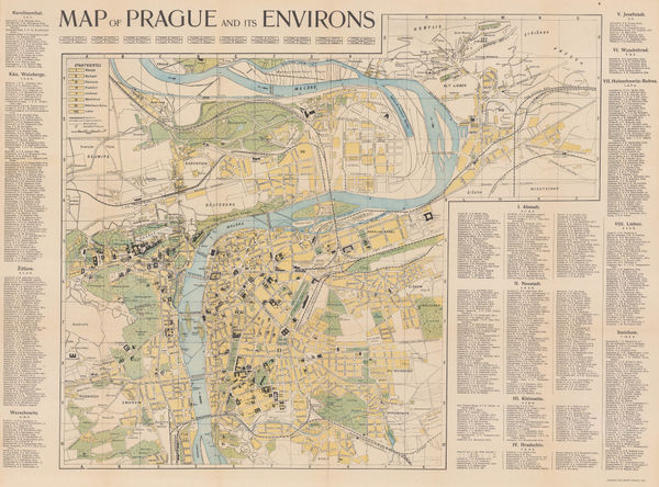
Charles Bellmann, Prague, 1905£ 325.00
-
Ernst Schotte & Co, Schottes Schul- & Familien-Globus, 1905 c.£ 3,500.00
-
Adolf Stieler, Eastern and Western Hemisphere, 1909£ 185.00
-
Enciclopedia Segui, Bucharest, 1910 (c.)£ 75.00
-
Enciclopedia Segui, Budapest, 1910 (c.)£ 85.00
-
Romolo Bullo, Rome, 1910 c.£ 545.00
-
Edward Stanford, Athens, 1910 c.£ 245.00
-
George W. Bacon, Bacon's Chart of Useful Knowledge, 1910 c.£ 3,600.00
-
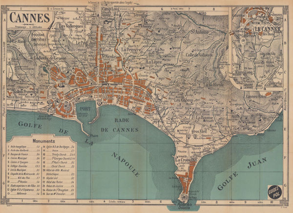
E. Fonne, Cannes, 1914£ 250.00
-
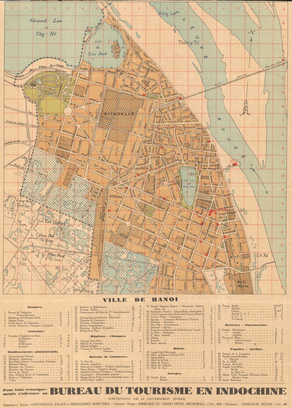
Anonymous, Hanoi, 1920£ 1,650.00
-
G. Thomas, 8-inch Globe Terrestre, 1920 (c.)£ 650.00
-
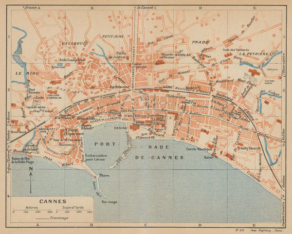
Eugène Dufrenoy, Cannes, 1921£ 58.00
-
Istanbul (Constantinople), 1922Société Anonyme Ottomane d'Etudes et d'Enterprises UrbainesSeries: IstanbulSociété Anonyme Ottomane d'Etudes et d'Enterprises Urbaines, Istanbul (Constantinople), 1922£ 950.00
-
John Bartholomew & Son, World Commerce Maps, 1922£ 225.00
-
John Bartholomew & Son, World Map of Vegetation and Ocean Currents, 1922£ 175.00
-
Japanese Railways, Environs of Hong Kong, 1924£ 275.00
-
George Philip & Son Ltd., Philip's 12 Inch Library Globe, 1924 c.£ 4,950.00
-
Alberto Martín, Plano de Madrid, 1927£ 495.00
-
Alberto Martín, Valencia, 1927£ 275.00
-
Alberto Martín, Bilbao, 1927£ 375.00
-
Edward Stanford, General Map of the World, 1928£ 645.00
-
Joseph Meyer, Athens, 1930£ 46.00
-
Vicente de Castro Les, Madrid, 1930£ 175.00
-
-
Almacenes Alemanes, Barcelona, 1932£ 545.00
-
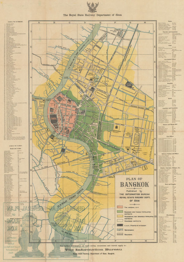
Siam Railways, Bangkok, 1932£ 895.00
-
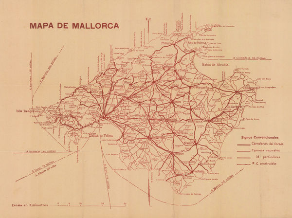
Libreria Escolar, Mallorca, 1933£ 145.00
-
A. de Boeck, Brussels (Bruxelles), 1935£ 350.00
-
Air France, Air France - Breguet-Wibault type 283 T, 1935£ 1,450.00
-
Imperial Airways, Imperial Airways - The Greatest Air Service in the World', 1935£ 1,950.00
-
Malmö Kartografiska Anstalt, Venice, 1935 c£ 65.00
-
Geographia Ltd., 10 inch Terrestrial Globe, 1935 c.£ 2,750.00
-
Lith. Ypiranga, Rio de Janeiro, 1936£ 950.00
-
Imperial Airways, Map of the Empire and European Air Routes, 1936£ 3,000 (framed)
-
French State Railway, Paris Welcomes You, 1937£ 2,000.00
-
Roto-Sadag, Geneva, 1937£ 175.00
-
-
Thomas Skinner, Air Routes of the World, 1938£ 900.00
-
Flying Magazine, The Empire Air Mail Scheme, 1938 c.£ 265.00


Page
1
of 2