-
 Haemisphaeria Sphaerarum Rectae et Obliquae Utriusque Motus et Longitudines tam Coelestes quam Terrestres ac Stellarum Affectiones Monsrantia, 1661Andreas CellariusSeries: AmsterdamAndreas Cellarius, Haemisphaeria Sphaerarum Rectae et Obliquae Utriusque Motus et Longitudines tam Coelestes quam Terrestres ac Stellarum Affectiones Monsrantia, 1661£ 3,500.00
 -
Hypothesis Ptolemaica, sive Communis Planetarum Motus per Eccentricos et Epicyclos Demonstrans, 1661Andreas CellariusSeries: AmsterdamAndreas Cellarius, Hypothesis Ptolemaica, sive Communis Planetarum Motus per Eccentricos et Epicyclos Demonstrans, 1661£ 3,500.00
-
-
-
Andreas Cellarius, Theoriatrium Superiorum Planetarum, 1661£ 3,500.00
-
-
Tabula Geographico-Hydrographica Motus Oceani, Currentes, Abyssos, Montes Ignivomos, 1670 c.Athanasius KircherSeries: RomeAthanasius Kircher, Tabula Geographico-Hydrographica Motus Oceani, Currentes, Abyssos, Montes Ignivomos, 1670 c.£ 2,700.00
-
Athanasius Kircher, Geographia Conjecturalis de Orbis Terrestris Post Diluvium, 1675£ 3,650.00
-
Tabula Geographico-Hydrographica Motus Oceani, Currentes, Abyssos, Montes Ignivomos in Universo Orbe Indicans, 1696Johann ZahnSeries: NurembergJohann Zahn, Tabula Geographico-Hydrographica Motus Oceani, Currentes, Abyssos, Montes Ignivomos in Universo Orbe Indicans, 1696£ 3,950.00
-
Nicolas & Guillaume Sanson, Astronomical Diagrams, 1700£ 245.00
-
Nicolas & Guillaume Sanson, Astronomical Diagrams - the Earth's Revolution, 1700£ 245.00
-
Nicolas & Guillaume Sanson, Astronomical Diagrams - Eclipses, 1700£ 245.00
-
Nicolas & Guillaume Sanson, Astronomical Diagrams - Earth's Orbit, 1700£ 245.00
-
Nicolas & Guillaume Sanson, Astronomical Diagrams - the Solar System, 1700£ 245.00
-
-
Die Ebbe und Fluth auff einer Flachen Landt-Karten Furgestelt, 1708Eberhard Werner HappelSeries: UlmEberhard Werner Happel, Die Ebbe und Fluth auff einer Flachen Landt-Karten Furgestelt, 1708£ 2,750.00
-
William Williams, Oxford, 1733£ 1,450.00
-
Jean-Dominique Cassini, Réduction de la grande Carte de la Lune de J. Dom. Cassini, 1788£ 4,500.00
-
-
Friedrich Justin Bertuch, La Lune et ses Montagnes, 1796£ 450.00
-
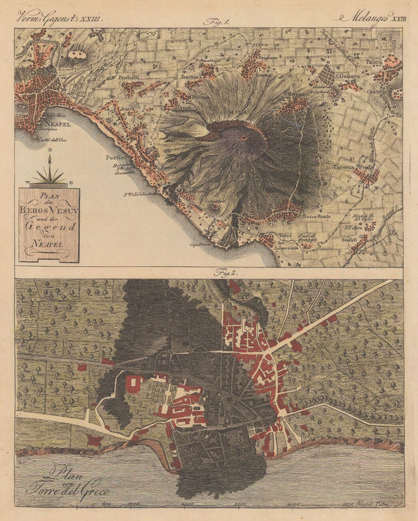
Friedrich Justin Bertuch, Naples and Mt Vesuvius with Torre del Greco, 1798£ 125.00
-
John Wilkes, Astronomy - Phenomena of the Moon, 1798£ 275.00
-
J. Freeman & Samuel Dana, A Geological Map of Boston and its Vicinity, 1818£ 1,450.00
-
A Geological Sketch of Malwa, and part of the Adjoining Provinces, 1823Capt. F. DangerfieldSeries: LondonCapt. F. Dangerfield, A Geological Sketch of Malwa, and part of the Adjoining Provinces, 1823£ 95.00
-
Duncan Bradford, Herschel's Forty-Foot Reflecting Telescope, 1837 c.£ 350.00
-
Comparative View of the Mountains, Rivers & Waterfalls of the World, 1839 c.Charles V. MoninSeries: Paris & LyonCharles V. Monin, Comparative View of the Mountains, Rivers & Waterfalls of the World, 1839 c.£ 1,750.00
-
Compartative View of the Principal Mountains and Rivers in the World, 1840 c.Sidney HallSeries: LondonSidney Hall, Compartative View of the Principal Mountains and Rivers in the World, 1840 c.£ 475.00
-
Charles V. Monin, Tableau Comparatif de la Hauteur des Montagnes, 1840 c.£ 475.00
-
A Set of Celestial Maps intended to assist Students in Astronomy, and Seamen in general, In acquiring a knowledge of the Principal Fixed Stars in the Heavens., 1844John William NorieSeries: LondonJohn William Norie, A Set of Celestial Maps intended to assist Students in Astronomy, and Seamen in general, In acquiring a knowledge of the Principal Fixed Stars in the Heavens., 1844£ 875.00
-
A Map of the Principal Rivers shewing their Courses, Countries, and Comparative Lengths, 1844Society for the Diffusion of Useful Knowledge (SDUK)Series: LondonSociety for the Diffusion of Useful Knowledge (SDUK), A Map of the Principal Rivers shewing their Courses, Countries, and Comparative Lengths, 1844£ 195.00
-
Ashford & Loader, Map and Sections of the Staffordshire Coal Field, 1845£ 125.00
-
Ashford & Loader, The Heights of the Mountains of the Eastern Hemisphere, 1845£ 975.00
-
James Reynolds, Waterfalls, 1846 c.£ 545.00
-
W. & A.K. Johnston, Zoological Geography - Monkeys, Marsupials & Pachyderms, 1848£ 595.00
-
W. & A.K. Johnston, Zoological Geography - Carnivores, 1848£ 595.00
-
W. & A.K. Johnston, Geological Phenomena, 1848£ 395.00
-
W. & A.K. Johnston, Illustrations of the Glacier Systems of the Alps, 1848£ 425.00
-
James Reynolds, Geological map of England, 1849£ 545.00
-
James Reynolds, Geological Map of the World, 1850 c£ 545.00
-
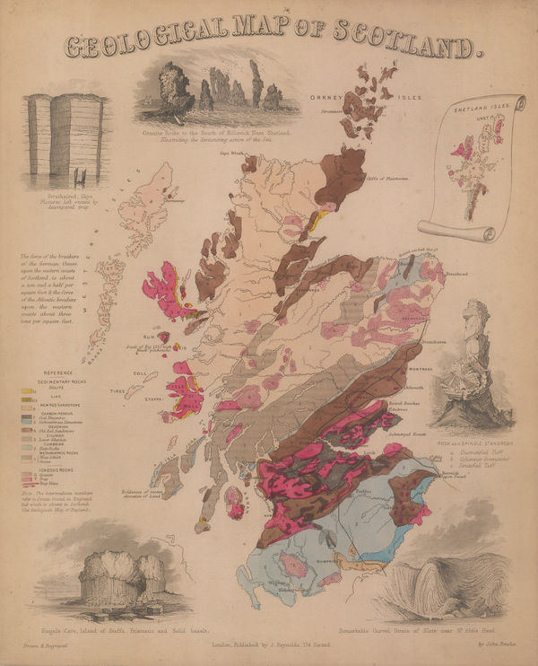
James Reynolds, Geological map of Scotland, 1850 c£ 545.00
-
Eugene Belin, Ciel et Terre, 1850 c.£ 475.00
-
James Reynolds, Cometes et Aérolithes, 1850 c.£ 295.00
-
James Reynolds, The Sun and Solar Phenomena, 1850 c.£ 325.00
-
Elliot Bros., Victorian Waywiser, 1850 c.£ 4,500.00
-
James Reynolds, Eclipses, 1851 c.£ 245.00
-
James Reynolds, The Theory of the Seasons and Signs of the Zodiac, 1851 c.£ 345.00
-
James Reynolds, Phenomena of Volcanoes and Earthquakes, 1852£ 495.00
-
Edward Hitchcock, A Geological Map of the United States and Canada, 1853£ 985.00
-
W. & A.K. Johnston, Geological Map of the World, 1855£ 750.00
-
W. & A.K. Johnston, The Crop Distribution of the World, 1855£ 375.00
-
W. & A.K. Johnston, Geological Map of Europe, 1856£ 3,500.00
-
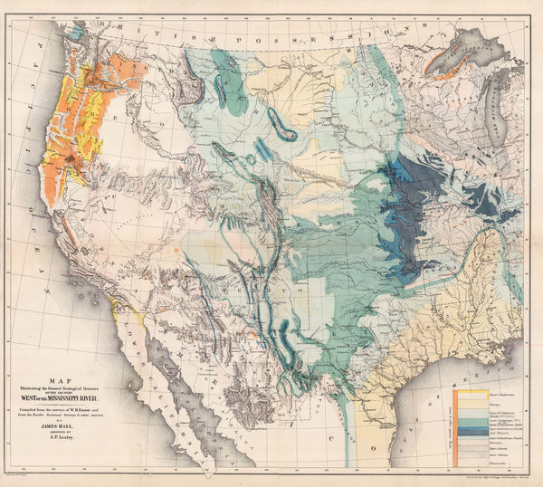
Map Illustrating the General Geological features of the Country West of the Mississippi River, 1857James HallSeries: Washington, D.C.James Hall, Map Illustrating the General Geological features of the Country West of the Mississippi River, 1857£ 1,350.00
-
Robert William Mylne, Geological and Topographical Map of London & its Environs, 1858£ 2,500.00
-
Justus Perthes, The Moon - Three Views of the Sea of Crises, 1858£ 225.00
-
James Reynolds, Eclipses, 1865 c.£ 850.00
-
James Reynolds, The Solar System, 1865 c.£ 850.00
-
Bernhard Studer, Geological map of Switzerland, 1869 c.£ 1,650.00
-
J. Berg, Tellurian, 1870 c.£ 5,250.00
-
-
Jules Marcou, Geological Map of the World, 1875£ 4,250.00
-
Victor Clerot, Mappemonde Orographique et Hydrographique, 1875 c.£ 4,500.00
-
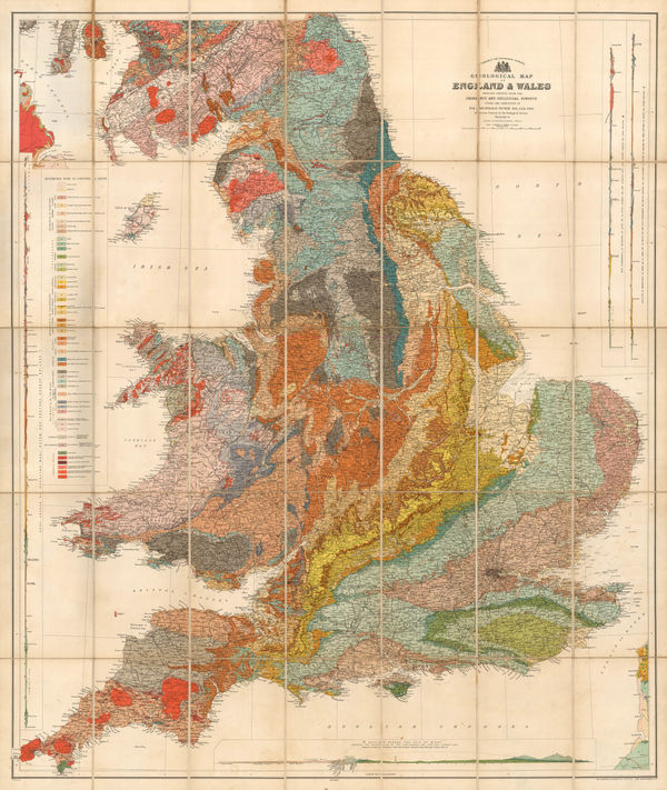
Sir Andrew Crombie Ramsay, Geological Map of England & Wales, 1876£ 725.00
-
Survey of India, Preliminary Sketch of the Geology of India, 1877£ 1,750.00
-
Edward Stanford, Geological Map of Ireland, 1878£ 1,200.00
-
-
-
Horne & Thornthwaite, Horne & Thornthwaite Brass Telescope, 1885 c.£ 2,500.00
-
Royal Geographical Society (RGS), Map of the World on Mercator's Projection, 1886£ 235.00
-
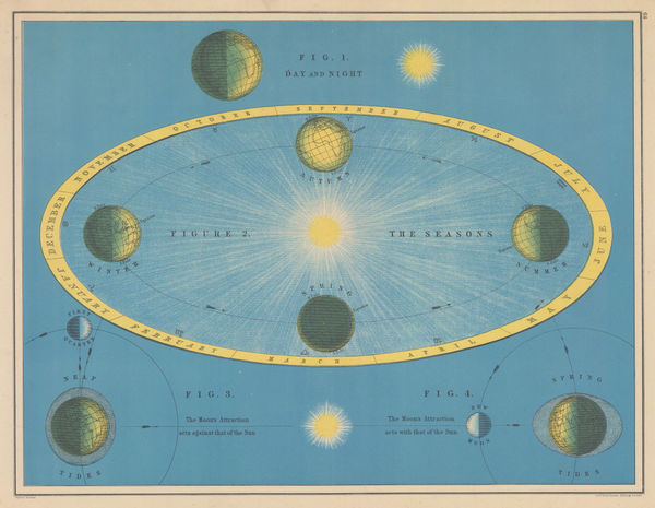
W. & A.K. Johnston, Astronomy - The Day/Night Cycle, Seasons & Tides, 1887£ 225.00
-
Scottish Geographical Society (SGS), Charles Darwin's Coral Reefs Theory, 1888£ 195.00
-
Justus Perthes, Population map of the United States and Canada, 1888£ 325.00
-
The Geographical Value of The Best Maps of All Countries of The World, 1890Scottish Geographical Society (SGS)Series: EdinburghScottish Geographical Society (SGS), The Geographical Value of The Best Maps of All Countries of The World, 1890£ 425.00
-
F.A. Brockhaus, Railway Development in the World, 1890£ 125.00
-
George W. Bacon, Oxford, 1890 (c.)£ 495.00
-
-
Justus Perthes, Annual Temperatures of the World's Oceans, 1893£ 145.00
-
Sir Archibald Geikie, Geological Map of the British Isles, 1896£ 3,500.00
-
Sir Archibald Geikie, Geological Map of England & Wales, 1897 (c.)£ 550.00
-
Edward Stanford, Stanford's Geological Map of London Shewing Superficial Deposits, 1899£ 425.00
-
Anonymous, Japanese Binoculars, 1900£ 4,500.00


![Henry L. Bryant, "Celestial Indicator" [Solar System Model], 1872 c.](https://static-assets.artlogic.net/w_600,c_limit,f_auto,fl_lossy,q_auto/artlogicstorage/themaphouse/images/view/5a601288d656f90361d6b0b76b015c12j/themaphouse-henry-l.-bryant-celestial-indicator-solar-system-model-1872-c..jpg)


Page
1
of 2