-
 Map of the Country between Odessa and Constantinople embracing the present Seat of War between the Russians and Turks, 1877 c.James WyldSeries: LondonJames Wyld, Map of the Country between Odessa and Constantinople embracing the present Seat of War between the Russians and Turks, 1877 c.£ 875.00
 -
Letts & Son, Turkey & the Balkans, 1878£ 850.00
-
Blackie & Son, The Austrian Empire, 1880 c.£ 80.00
-
A. Simon, Chart of the port of Rijeka, 1883£ 125.00
-
Karl Baedeker, Budapest, 1885£ 125.00
-
Sir Archibald Alison, Battle of Austerlitz, 1885£ 175.00
-
Justus Perthes, Dobrudscha zur Ubersicht der Deutschen Kolonien, 1886£ 58.00
-
J.G. Bartholomew, Austria-Hungary, 1887£ 55.00
-
Arbuckle Brothers Company, Türkiye (Turkey), 1889£ 95.00
-
J. Migeon, Turquie D'Europe, 1890 c.£ 42.00
-
Karl Baedeker, Danube River in Serbia & Romania, 1890 c.£ 38.00
-
Royal Geographical Society (RGS), Montenegro, Albania and Novibazar, 1894£ 195.00
-
Justus Perthes, Montenegro, 1894£ 145.00
-
Homolka József, Budapest, 1903£ 2,450.00
-
George Bradshaw, Budapest, 1904£ 325.00
-
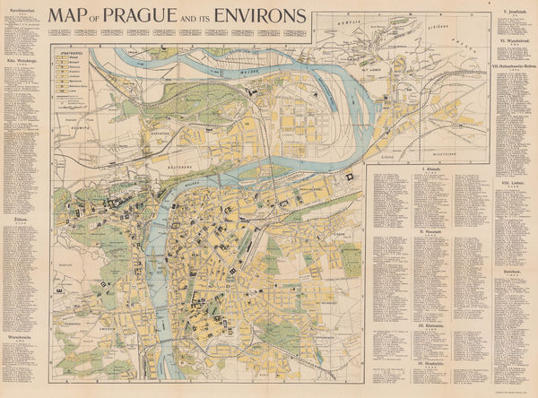
Charles Bellmann, Prague, 1905£ 325.00
-
W. Krzepowski, Kraków (Cracow), 1910 (c.)£ 295.00
-
Enciclopedia Segui, Bucharest, 1910 (c.)£ 75.00
-
Enciclopedia Segui, Belgrade, 1910 (c.)£ 125.00
-
Enciclopedia Segui, Budapest, 1910 (c.)£ 85.00
-
Balkan States & Asia Minor: Industries & Communications, 1910 c.George Philip & Son Ltd.Series: LondonGeorge Philip & Son Ltd., Balkan States & Asia Minor: Industries & Communications, 1910 c.£ 125.00
-
George Philip & Son Ltd., Austria-Hungary: Industries & Communications, 1910 c.£ 145.00
-
Adolf Hartleben, Opatija, Croatia, 1913£ 32.00
-
Adolf Hartleben, Rab, Croatia, 1913£ 28.00
-
Adolf Hartleben, Adriatic Coast from Pula to Zadar, Croatia, 1913£ 36.00
-
Adolf Hartleben, Map of the train route from Sarajevo to Ragusa (Dubrovnik), 1913£ 32.00
-
Adolf Hartleben, Port and city of Pula, Croatia, 1913£ 34.00
-
Adolf Hartleben, Hvar, Croatia, 1913£ 48.00
-
Adolf Hartleben, Lošinj, Croatia, 1913£ 32.00
-
Adolf Hartleben, Solin, Croatia, 1913£ 28.00
-
Adolf Hartleben, Rijeka, Croatia, 1913£ 32.00
-
Adolf Hartleben, Lovran and Ika, Croatia, 1913£ 36.00
-
Adolf Hartleben, Pula, Croatia, 1913£ 68.00
-
Adolf Hartleben, Split, Croatia, 1913£ 24.00
-
Adolf Hartleben, Zadar, Croatia, 1913£ 32.00
-
Teofil Szumanski, Poland , 1919£ 1,250.00
-
Alexander Gross, New Map of Poland, 1921 c£ 350.00
-
V. Neubert, Prague, 1924£ 125.00
-
Victor Tanasescu, Wall Map of Greater Romania, 1925£ 2,250.00
-
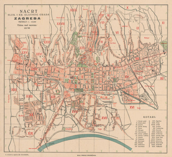
S. Kugli, Zagreb, 1929£ 295.00
-
Tymoteusz Sawicki, Warsaw, 1930£ 495.00
-
Freytag & Berndt, The Yugoslavian Riviera (Croatia & Bosnia), 1930 (c.)£ 400.00
-
Feliks Kasprzykiewicz, Warsaw, 1932£ 325.00
-
Karl Baedeker, Rijeka, Croatia, 1934£ 36.00
-
B. Rosenthal, Plan of Warsaw, 1935£ 485.00
-
Municipal Information Office, Budapest, 1936£ 395.00
-
Gyorgy Stoits, Budapest, 1940 c.£ 495.00
-
Luftwaffe, WW2-era map of Minsk, 1941 c.£ 595.00
-
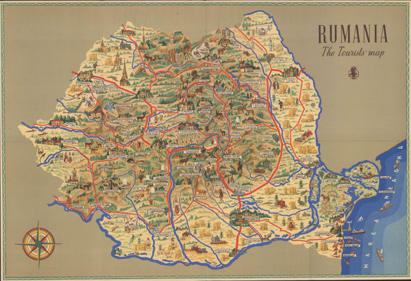
ONT Carpati, Vintage tourist map of Romania, 1950 c.£ 295.00
-
Jacques Liozu, Pictorial map of Central and Eastern Europe, 1951£ 165.00
-
Vlasto Kopac, Yugoslavia, 1954£ 275.00
-
Tourism Administration, Belgrade, 1960 c.£ 95.00
-
Istituto Idrografico, Croatian islands of Lastovo and Korčula, 1961£ 700.00
-
Olivera Bravacic, Dubrovnik, 1962£ 250.00
-
PPWK (Państwowe Przedsiębiorstwo Wydawnictw Kartograficznych), Kraków, 1962£ 225.00
-
Istituto Idrografico, Montenegro coast, 1963£ 700.00
-
Central Geographical Office, Poland, 1966£ 950.00
-
PPWK (Państwowe Przedsiębiorstwo Wydawnictw Kartograficznych), Krakow, 1974£ 175.00


Page
3
of 3