-

-
-
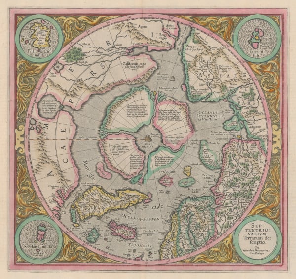
Jan Blaeu, Regiones Svb Polo Arctico, 1650 c.£ 950.00
-
Frederick De Wit, Terra Australis Incognita, 1680 c.£ 1,250.00
-
Vincenzo Coronelli, Terre Artiche, 1695 c.£ 2,950.00
-
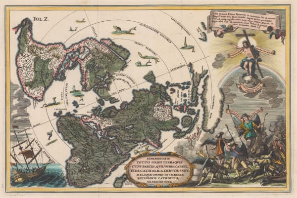
Repraesentatio Totius Orbis Terraquei Cuius Partes, Quae Umbra Carent, Fide Catholica Imbutae Sunt, Reliquae Omnes Inumbratae Religionis Catholicae Expertes Sunt., 1700 c.Heinrich SchererSeries: MunichHeinrich Scherer, Repraesentatio Totius Orbis Terraquei Cuius Partes, Quae Umbra Carent, Fide Catholica Imbutae Sunt, Reliquae Omnes Inumbratae Religionis Catholicae Expertes Sunt., 1700 c.£ 1,275.00
-
Heinrich Scherer, Regionvm Circvm Polarivm, 1701£ 950.00
-
This Draught of the North Pole is to shew all the Countries near and adjacent to it, 1705Herman MollSeries: LondonHerman Moll, This Draught of the North Pole is to shew all the Countries near and adjacent to it, 1705£ 1,450.00
-
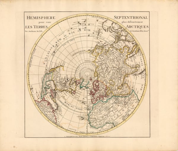
Hemisphere Septentrional - Les Terres Arctiques, 1733Covens (Jean) & Mortier (Cornelius)Series: AmsterdamCovens (Jean) & Mortier (Cornelius), Hemisphere Septentrional - Les Terres Arctiques, 1733£ 650.00
-
Henri du Sauzet, Terres Antarctiques, 1734Sold
-
Herman Moll, A Map of the North Pole, 1750 c.£ 650.00
-
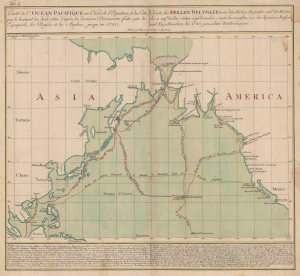
Russian Discoveries in Siberia, Alaska & the Bering Strait, 1750 c.Jacques-Nicolas BellinSeries: ParisJacques-Nicolas Bellin, Russian Discoveries in Siberia, Alaska & the Bering Strait, 1750 c.£ 725.00
-
Jacques-Nicolas Bellin, White Sea, 1764£ 125.00
-
Maurille-Antoine Moithey, Le Globe Terrestre vu en convexe par les deux Poles, 1769£ 1,350.00
-
Northwestern USA, Eastern Russia and the North Pacific, 1770 c.Johann Heinrich HeideggerSeries: ZurichJohann Heinrich Heidegger, Northwestern USA, Eastern Russia and the North Pacific, 1770 c.£ 795.00
-
Robert Sayer, Russian Discoveries in Siberia, Alaska & the Bering Strait, 1775£ 1,325.00
-
Antonio Zatta, Emisfero Terrestre Meridionale | Emisfero Terrestre Septentrionale, 1779£ 645.00
-
J.C. & J.A. Dezauche, Planisphere Physique, 1780£ 1,150.00
-
Tobias Conrad Lotter, James Cook's Voyage to the North Pacific & Bering Strait, 1781£ 2,750.00
-
Gerhard Friedrich Muller, Russian Discoveries in Siberia, Alaska & the Bering Strait, 1784Sold
-
Carte de L'Hemisphere Austral Montrant les Routes des Navigateurs les plus Célebres Par le Captaine Jacques Cook, 1790 c.Capt. James CookSeries: ParisCapt. James Cook, Carte de L'Hemisphere Austral Montrant les Routes des Navigateurs les plus Célebres Par le Captaine Jacques Cook, 1790 c.£ 2,500.00
-
Capt. James Cook, Van Kerguelens Land, 1794Sold
-
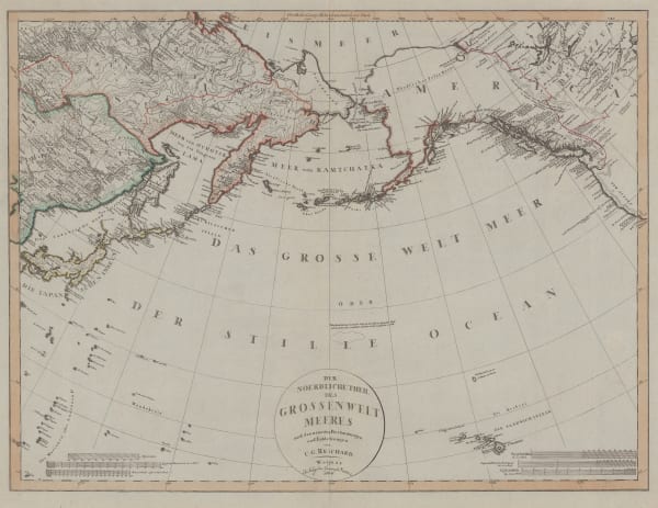
Christian Gottlieb Reichard, Chart of the North Pacific Ocean, 1804£ 785.00
-
-
John Wilkes, Countries surrounding the South Pole, 1807£ 295.00
-
John Wilkes, Countries Surrounding the North Pole, 1807£ 225.00
-
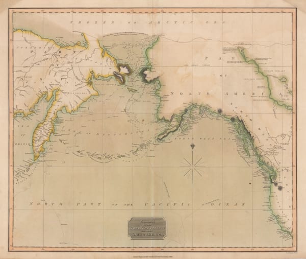
William Faden, James Cook's Voyage to Alaska & the Bering Strait, 1808£ 2,850.00
-
John Thomson, Chart of the North Pacific and Behring Straits, 1816£ 525.00
-
John Thomson, Northern and Southern Hemispheres, 1820 c.£ 1,250.00
-
John Thomson, Northern and Southern Hemispheres, 1820 c.£ 2,500.00
-
Chart of Part of the North Eastern Coast of America, and its adjacent Islands, 1824Sir William Edward ParrySeries: LondonSir William Edward Parry, Chart of Part of the North Eastern Coast of America, and its adjacent Islands, 1824£ 545.00
-
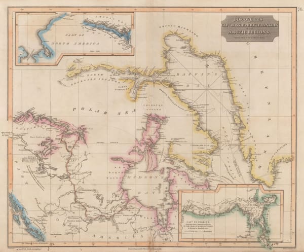
John Thomson, Discoveries of Ross, Parry & Franklin in the Arctic , 1830 c.£ 2,950.00
-
Royal Geographical Society (RGS), Hudson's Strait, 1837Sold
-
Geographical Diagram of the Earth Adapted for Illustrating its Movements &c., 1840 c.James ReynoldsSeries: LondonJames Reynolds, Geographical Diagram of the Earth Adapted for Illustrating its Movements &c., 1840 c.£ 275.00
-
Benedetto Marzolla, Carta Generale dell'Antartica, 1842£ 1,450.00
-
Royal Geographical Society (RGS), Frobisher Strait & Northumberland Inlet, 1842£ 145.00
-
Perspective Projection of the Southern Hemisphere on the Plane of the Horizon of London, 1845 c.Joseph Wilson LowrySeries: LondonJoseph Wilson Lowry, Perspective Projection of the Southern Hemisphere on the Plane of the Horizon of London, 1845 c.£ 745.00
-
The World, the World on a Polar Projection & recent Antarctic Discoveries, 1847 (c.)Samuel Augustus MitchellSeries: PhiladelphiaSamuel Augustus Mitchell, The World, the World on a Polar Projection & recent Antarctic Discoveries, 1847 (c.)£ 175.00
-
British Admiralty, Chart of the North Polar Sea, 1849£ 950.00
-
James Wyld, Chart of the Arctic Regions from the Admiralty Surveys, 1851 c.£ 2,950.00
-
Royal Geographical Society (RGS), Chart of the Arctic Coast, 1852£ 375.00
-
Chart of the Northern portion of Baffin Bay to illustrate Col. Inglefields report., 1853Royal Geographical Society (RGS)Series: LondonRoyal Geographical Society (RGS), Chart of the Northern portion of Baffin Bay to illustrate Col. Inglefields report., 1853£ 145.00
-
Joseph Meyer, Neueste Karte vom Sud-Pol, 1853£ 595.00
-
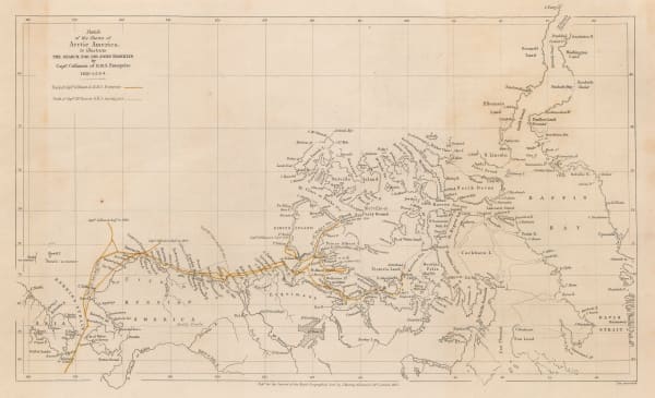
Sketch of the Shores of Arctic America to illustrate the Discovery of the Northwest Passage, 1855Royal Geographical Society (RGS)Series: LondonRoyal Geographical Society (RGS), Sketch of the Shores of Arctic America to illustrate the Discovery of the Northwest Passage, 1855£ 375.00
-
Joseph Hutchins Colton, Southern Regions, 1855£ 450.00
-
The Northwest Passage and the Search for Sir John Franklin, 1855Royal Geographical Society (RGS)Series: LondonRoyal Geographical Society (RGS), The Northwest Passage and the Search for Sir John Franklin, 1855£ 395.00
-
Justus Perthes, Queen Elizabeth Islands (Parry Archipelago), 1855£ 595.00
-
A. & C. Black, Arctic Regions and British America, 1856£ 325.00
-
The Route of Sir John Franklin's Doomed Arctic Expedition, 1856Royal Geographical Society (RGS)Series: LondonRoyal Geographical Society (RGS), The Route of Sir John Franklin's Doomed Arctic Expedition, 1856£ 595.00
-
Royal Geographical Society (RGS), Discoveries of the American Expedition, 1856£ 295.00
-
Archibald Fullarton, Wellington Channel, Melville Island &c., 1856£ 82.00
-
Royal Geographical Society (RGS), American Arctic Expedition, 1853_4_5, 1858Sold
-
Übersichtskarte der wahrscheinlichen Route von Sir J. Franklin's Expedition, 1859Justus PerthesSeries: GothaJustus Perthes, Übersichtskarte der wahrscheinlichen Route von Sir J. Franklin's Expedition, 1859£ 95.00
-
Joseph Hutchins Colton, Northern Regions, 1861£ 115.00
-
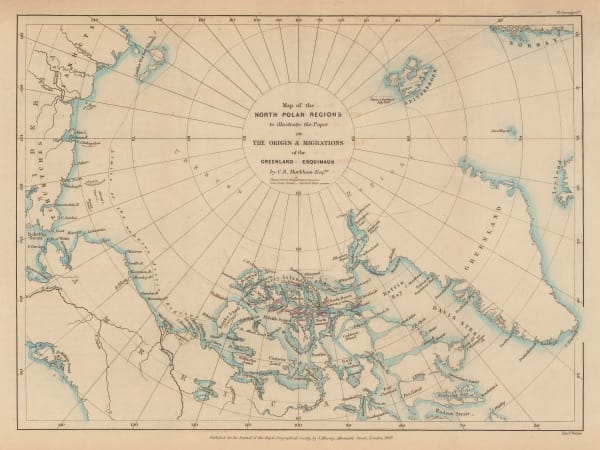
Royal Geographical Society (RGS), Map of the North Polar Regions, 1865£ 185.00
-
Justus Perthes, Arctic & Antarctic Discoveries, 1868£ 295.00
-
Justus Perthes, Die Meeres-Temperatur des Grönländischen Meeres, 1869£ 88.00
-
Royal Geographical Society (RGS), The South-Polar Regions, 1869£ 950.00
-
Justus Perthes, Arctic Russia, Wrangel Island & the Bering Strait, 1869£ 125.00
-
Surface Temperatures of the North Atlantic between Shetland & Greenland, 1870Royal Geographical Society (RGS)Series: LondonRoyal Geographical Society (RGS), Surface Temperatures of the North Atlantic between Shetland & Greenland, 1870£ 155.00
-
Justus Perthes, Arctic Temperature Maps, 1870£ 145.00
-
Justus Perthes, Ice Limits in the Greenland Sea, 1877£ 78.00
-
The Graphic Magazine, The Jeannette Expedition, 1878£ 275.00
-
Royal Geographical Society (RGS), King William Land, 1880£ 115.00
-
Royal Geographical Society (RGS), Map of the Barents & Kara Seas, 1880£ 195.00
-
Chart Showing Mr. Leigh Smith's Track to Franz Josef Land and Boat Journey to Novaya Zemlya in 1881-1882, 1883Royal Geographical Society (RGS)Series: LondonRoyal Geographical Society (RGS), Chart Showing Mr. Leigh Smith's Track to Franz Josef Land and Boat Journey to Novaya Zemlya in 1881-1882, 1883£ 75.00
-
Royal Geographical Society (RGS), The Greely Expedition, 1884£ 320.00
-
The Geographical Discoveries of Lieut. Greely's Expedition, 1882-3., 1885Scottish Geographical Society (SGS)Series: EdinburghScottish Geographical Society (SGS), The Geographical Discoveries of Lieut. Greely's Expedition, 1882-3., 1885Sold
-
South Polar Chart showing Heights of Land and Depths of Sea, 1886Scottish Geographical Society (SGS)Series: EdinburghScottish Geographical Society (SGS), South Polar Chart showing Heights of Land and Depths of Sea, 1886£ 1,600.00
-
J.G. Bartholomew, North Polar Regions, 1887£ 66.00
-
Augustus Petermann, Sud-Polar Karte, 1889£ 950.00
-
Royal Geographical Society (RGS), Nansen's First Crossing of Greenland, 1889£ 245.00
-
Justus Perthes, Die Arktische Windscheide und die Neuesten Polarprojekte, 1891£ 92.00
-
Sketch Map of Arctic Regions Showing Dr. Nansen's Projected Route, 1892Scottish Geographical Society (SGS)Series: EdinburghScottish Geographical Society (SGS), Sketch Map of Arctic Regions Showing Dr. Nansen's Projected Route, 1892£ 225.00
-
Levi Walter Yaggy, Arctic Zone, 1893£ 1,800.00
-
Map Illustrating Mr H. O. Forbes' paper on The Chatham Islands., 1893Royal Geographical Society (RGS)Series: LondonRoyal Geographical Society (RGS), Map Illustrating Mr H. O. Forbes' paper on The Chatham Islands., 1893£ 445.00
-
Map Shewing Route of the North Greenland Expedition of 1891-92, 1893Royal Geographical Society (RGS)Series: LondonRoyal Geographical Society (RGS), Map Shewing Route of the North Greenland Expedition of 1891-92, 1893£ 125.00
-
Scottish Geographical Society (SGS), Sketch Map of South Polar Regions, 1894£ 450.00
-
Sketch-Chart on Mercator's Projection, Showing Track of the 'Jason', 1893-94, 1894Scottish Geographical Society (SGS)Series: EdinburghScottish Geographical Society (SGS), Sketch-Chart on Mercator's Projection, Showing Track of the 'Jason', 1893-94, 1894£ 950.00
-
Scottish Geographical Society (SGS), Chart of North Polar Regions, 1897£ 595.00


Page
1
of 2