North & Northwest London Maps
-
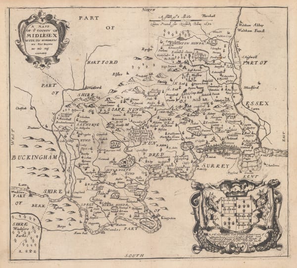
 John Norden & William Kip, Middlesex, or North & West London, 1637£ 850.00
 -
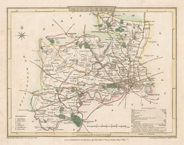
Richard Blome, Middlesex, or North & West London, 1673£ 475.00
-
John Seller, Middlesex, 1690 c.£ 195.00
-
William Maitland, Islington, Holborn, Clerkenwell & Farringdon, 1755£ 475.00
-
London Magazine, A Plan of the New Road from Paddington to Islington, 1756£ 75.00
-
John Rocque, Middlesex, or North & West London, 1757£ 1,450.00
-
Russell & Price, Middlesex, 1769£ 115.00
-
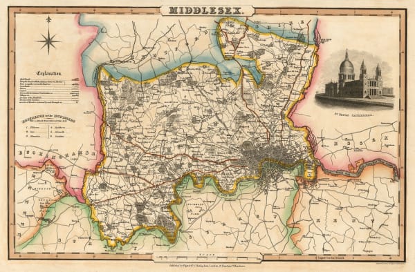
Thomas Bowen, County of Middlesex, 1777£ 585.00
-
George Bickham, Bird's-Eye view of London, 1796£ 550.00
-
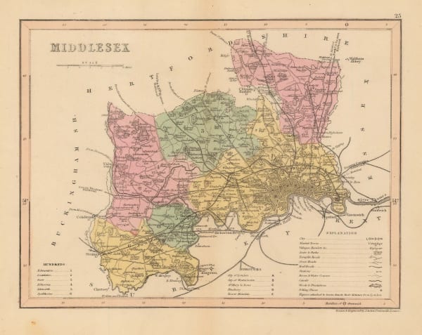
John Cary, A New Map of Middlesex, 1801£ 525.00
-
Cole & Roper, Middlesex, 1807£ 55.00
-
Christopher & John Greenwood, Map of the County of Middlesex, 1829£ 475.00
-
Joshua Archer, Middlesex, 1830 c.£ 44.00
-
Isaac Slater, Middlesex, 1830 c.£ 180.00
-
-
George Prickett, Plan of Highgate, 1842£ 595.00
-
George Prickett, Highgate and Hornsey Park, 1842£ 395.00
-
Willesden Green, Cricklewood, Childs Hill, Golders Green, Neasden & Wembley Park, 1849James WyldSeries: LondonJames Wyld, Willesden Green, Cricklewood, Childs Hill, Golders Green, Neasden & Wembley Park, 1849£ 295.00
-
James Wyld, Hampstead, Kentish Town, Highgate, Holloway, Islington & Crouch End, 1849£ 795.00
-
George Frederick Cruchley, Middlesex, 1850 c.£ 48.00
-
Edward Weller, Primrose Hill, St. John's Wood & Hampstead, 1863£ 795.00
-
Edward Weller, Bayswater, Notting Hill, Kensal Green, Shepherds Bush &c., 1863£ 495.00
-
John Cassell, North London, 1868 (c.)£ 565.00
-
Edward Stanford, Hoxton, Islington, Canonbury & Dalston, 1877£ 795.00
-
Edward Stanford, Highgate, Kentish Town & Holloway, 1877£ 645.00
-
Edward Stanford, Hampstead, Golders Green & Cricklewood, 1877£ 495.00
-
Edward Stanford, Regent's Park, Camden, Primrose Hill & King's Cross, 1877£ 950.00
-
George W. Bacon, Primrose Hill, St. John's Wood, Camden & Hampstead, 1880 (c.)£ 975.00
-
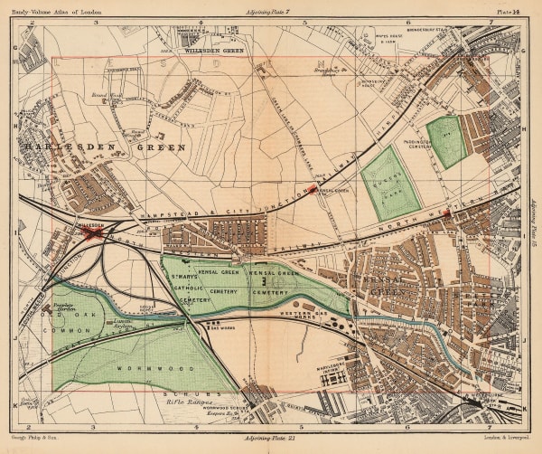
George W. Bacon, [Cricklewood & Willesden Green], 1880 c.£ 160.00
-
George W. Bacon, Finsbury Park, Crouch End, Tottenham, Leyton & Walthamstow, 1880 c.£ 365.00
-
Edward Stanford, Finsbury Park, Stoke Newington & Tottenham, 1882£ 575.00
-
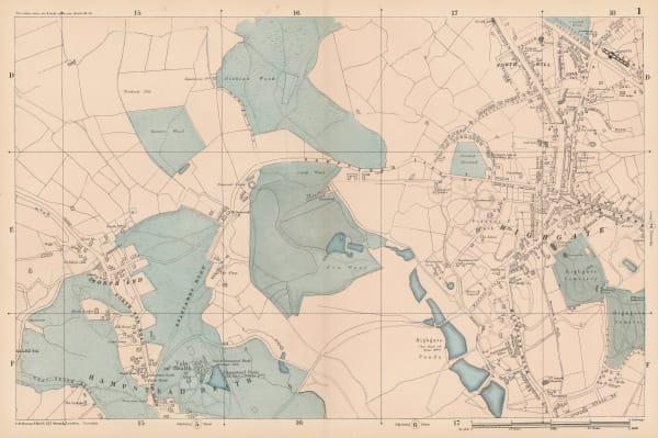
George W. Bacon, North & Northwest London, 1885 c.£ 385.00
-
Hampstead, Golders Green, Hendon, Muswell Hill, Alexandra Palace & Highgate, 1885 c.George W. BaconSeries: LondonGeorge W. Bacon, Hampstead, Golders Green, Hendon, Muswell Hill, Alexandra Palace & Highgate, 1885 c.£ 495.00
-
George W. Bacon, Finsbury Park, Crouch End, Holloway Road & Highgate Hill, 1886£ 295.00
-
George W. Bacon, Hendon, Mill Hill, Colney & Finchley, 1886£ 195.00
-
George W. Bacon, Hampstead Heath, Golders Green, Willesden Green & Cricklewood, 1886£ 295.00
-
George W. Bacon, Primrose Hill, Camden & Kentish Town, 1886£ 385.00
-
George W. Bacon, King's Cross, Caledonian Road & Holloway, 1886£ 325.00
-
George W. Bacon, Hampstead Heath, Highgate & Kenwood, 1886£ 425.00
-
George W. Bacon, Highgate, Crouch End & Finsbury Park, 1886£ 325.00
-
George Philip & Son Ltd., The County of Middlesex, 1888£ 35.00
-
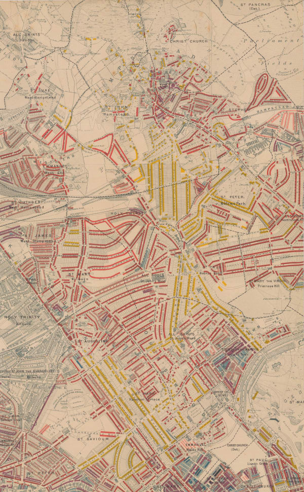
Charles Booth, Charles Booth's Poverty Map of London (NW), 1889£ 3,750.00
-
George W. Bacon, Plan of the Parsh of St. Marylebone, 1890£ 695.00
-
George W. Bacon, Hampstead, Golders Green, Finchley, Highgate, 1890 c£ 675.00
-
George Philip & Son Ltd., Brent Reservoir, 1891£ 40.00
-
George Philip & Son Ltd., Highgate & Alexandra Palace, 1891 c.£ 48.00
-
George Philip & Son Ltd., Kensal Green, Harlesden, Kilburn & Queen's Park, 1892£ 44.00
-
Edward Stanford, Stanford's Map of the County of London - Sheet 3, 1894£ 795.00
-
Charles Booth, Poverty Map of Islington, Highbury, & Stoke Newington, 1900£ 1,550.00
-
Charles Booth, Poverty Map of Camden, King's Cross & Kentish Town, 1900£ 985.00
-
George W. Bacon, Tottenham, Walthamstow, Edmonton & Epping Forest, 1900£ 195.00
-
J.G. Bartholomew, North & East London, 1900 (c.)£ 375.00
-
George Philip & Son Ltd., Golders Green, Brent Cross & Hendon, 1900 c.£ 44.00
-
George W. Bacon, Large Scale Plan of Harrow, 1900 c.£ 115.00
-
Charles Booth, Poverty Map of Hampstead and St. John's Wood, 1900 c.£ 1,350.00
-
George W. Bacon, North Kensington, Kensal Green, Queens Park & Wormwood Scrubs, 1900 c.£ 165.00
-
Sir Joseph Causton & Sons, The Metropolitan Borough of Paddington, 1901£ 950.00
-
George W. Bacon, Bayswater, Kensington, Paddington, Kilburn & Queens Park, 1902£ 68.00
-
George Philip & Son Ltd., Kentish Town, Holloway & Archway, 1904£ 80.00
-
George Philip & Son Ltd., Kew Gardens & London Zoo, 1904£ 58.00
-
George W. Bacon, West and Northwest London, 1905 c£ 595.00
-
George W. Bacon, North & Northwest London, 1910 (c.)£ 850.00
-
George W. Bacon, North and Northwest London, 1910 c£ 495.00
-
George W. Bacon, East and Northeast London, 1910 c£ 425.00
-
J.G. Bartholomew, Plan of London, North-West Section, 1910 c.£ 395.00
-
George W. Bacon, Hampstead, Willesden, Finchley and Paddington, 1910 c.£ 46.00
-
Ordnance Survey, Watford and High Wycombe, 1912 c.£ 115.00
-
Ordnance Survey, Highgate Village, 1921 c.£ 1,250.00
-
J.G. Bartholomew, Harrow, Wembley and Ealing, 1929£ 42.00
-
Marylebone, Bloomsbury, King's Cross, Euston & Regent's Park, 1929John Bartholomew & SonSeries: EdinburghJohn Bartholomew & Son, Marylebone, Bloomsbury, King's Cross, Euston & Regent's Park, 1929£ 68.00
-
John Bartholomew & Son, Hampstead, Camden, Kentish Town & Holloway, 1929£ 78.00
-
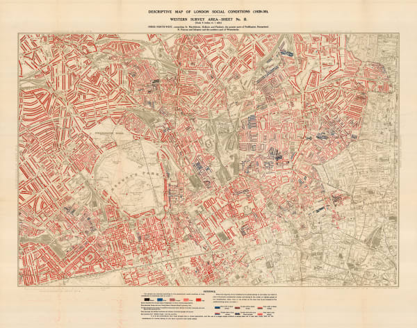
Charles Booth, Descriptive Map of London Social Conditions (1929-1930), 1930£ 1,950.00
-
Charles Booth, Descriptive Map of London Social Conditions (1929-1930), 1930£ 950.00
-
Ordnance Survey, Primrose Hill and St. Pancras, 1931 c.£ 825.00
-
Ordnance Survey, Kings Cross and Angel, 1933 c.£ 1,150.00
-
Ordnance Survey, Islington and Barnsbury, 1934 c.£ 925.00
-
Ordnance Survey, Highbury, 1935 c.£ 795.00
-
Ordnance Survey, North Hampstead, 1935 c.£ 425.00
-
Ordnance Survey, Queens Park and Kensal Town, 1935 c.£ 625.00
-
Ordnance Survey, Regents Park, 1935 c.£ 845.00


![George W. Bacon, [Cricklewood & Willesden Green], 1880 c.](https://artlogic-res.cloudinary.com/w_600,c_limit,f_auto,fl_lossy,q_auto/artlogicstorage/themaphouse/images/view/cf53116b3099c7da6fc4c3e03a263439j/themaphouse-george-w.-bacon-cricklewood-willesden-green-1880-c..jpg)


Page
1
of 2