New Maps / March 2026
-

-
The Map House - Petrus Bertius, Africae pars meridional., 1616£ 495.00
-
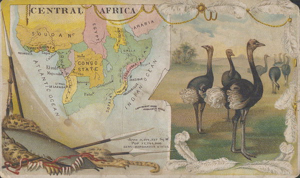
The Map House - Scottish Geographical Society (SGS), A Map of Rhodesia, 1900£ 375.00
-
The Map House - Nicolas Sanson, West and Northwest Africa, 1692£ 375.00
-
The Map House - John Pinkerton, Egypt, 1813£ 545.00
-
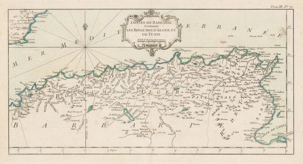
The Map House - Jacques-Nicolas Bellin, Algeria & Tunisia, 1764£ 175.00
-
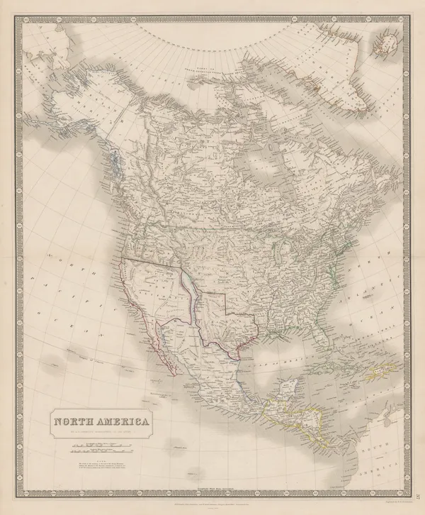
The Map House - W. & A.K. Johnston, North America, 1843£ 925.00
-
The Map House - Aaron Arrowsmith & Samuel Lewis, North America, 1812£ 295.00
-
The Map House - Aaron Arrowsmith & Samuel Lewis, Australasia, 1812£ 375.00
-
The Map House - Jacques-Nicolas Bellin, Montreal, 1764£ 975.00
-
The Map House - Jacques-Nicolas Bellin, Plan of Quebec City, 1764£ 425.00
-
The Map House - Jacques-Nicolas Bellin, Newfoundland, 1764£ 245.00
-
The Map House - Jacques-Nicolas Bellin, Canada & New England, 1764£ 495.00
-
The Map House - Ethelbert William Bullinger, Centaurus (the Centaur), 1921£ 65.00
-
The Map House - Ethelbert William Bullinger, XXXIV. Canis Major and Canis Minor (The Dogs), 1921£ 85.00
-
The Map House - Richard Anthony Proctor, Stars for July & August, 1901£ 95.00
-
The Map House - Richard Anthony Proctor, Stars for December & January, 1886£ 95.00
-
The Map House - Willem & Jan Blaeu, Cheshire, 1650 c.£ 845.00
-
The Map House - George W. Bacon, Cornwall, 1895£ 115.00
-
The Map House - Samuel Lewis, Devon, 1842£ 85.00
-
The Map House - Samuel Lewis, Dorset, 1842£ 68.00
-
The Map House - George Philip & Son Ltd., The County of Essex, 1895 c.£ 50.00
-
Thomas KitchinThe Roman Empire (East & West), 181516 x 18 ½ in (west), 16 x 17 in (east)
40 x 47 cm (west), 41 x 43 cm (east)The Map House - Thomas Kitchin, The Roman Empire (East & West), 1815£ 550.00 -
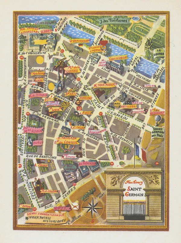
The Map House - Lucien Boucher, Faubourg Saint Germain, 1949£ 65.00
-
The Map House - Lucien Boucher, Montparnasse, 1949£ 55.00
-
The Map House - Lucien Boucher, Paris, 1949£ 425.00
-
The Map House - John Speed, Anglo-Saxon Britain, 1676£ 4,750.00
-
The Map House - Aaron Arrowsmith & Samuel Lewis, United Kingdom, 1812£ 95.00
-
The Map House - Joseph Meyer, Munich, 1844£ 495.00
-
The Map House - Samuel Lewis, Gloucestershire, 1842£ 75.00
-
The Map House - Philipp Cluver, Macedoniae et Thessaliae Regiones, 1711£ 145.00
-
The Map House - John Bartholomew & Son, Greece & the Aegean Sea, 1922£ 95.00
-
The Map House - Isaac Slater, Herefordshire, 1850 c.£ 75.00
-
-
The Map House - Georg Braun & Frans Hogenberg, Casablanca, Azemmour, Diu & Goa, 1590 c.£ 1,750.00
-
The Map House - Alf Cooke Ltd., India, 1946 c.£ 2,950.00
-
The Map House - J. Emerson Tennent, Portuguese Map of Ceylon, A.D. 1685, 1860£ 58.00
-
The Map House - Aaron Arrowsmith & Samuel Lewis, Hindoostan, 1812£ 125.00
-
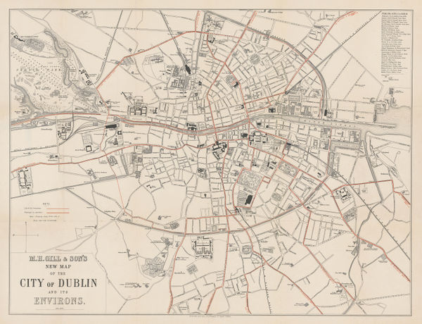
The Map House - M. H. Gill, New Map of the City of Dublin, 1900£ 495.00
-
-
The Map House - E. Rinaldi, A Visitor's Map of Florence, 1949£ 345.00
-
The Map House - Jacques-Nicolas Bellin, Genoa, 1764£ 285.00
-
The Map House - Fotorapidacolor, Siena, 1970 c.£ 135.00
-
The Map House - Samuel Lewis, Lancashire, 1842£ 75.00
-
The Map House - Harry Beck, First Edition, 1933£ 4,500.00
-
John Walter FroggettFroggett's Survey of the Country Thirty Miles Round London, 183344 x 54 in
112 x 137 cmThe Map House - John Walter Froggett, Froggett's Survey of the Country Thirty Miles Round London, 1833£ 3,950.00 -
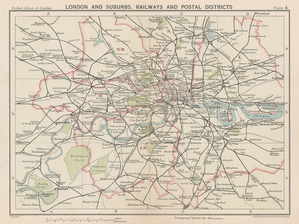
John Bartholomew & SonLondon and Suburbs, Railways and Postal Districts, 19296 ½ x 8 ½ in
16 x 21 cmThe Map House - John Bartholomew & Son, London and Suburbs, Railways and Postal Districts, 1929£ 68.00 -
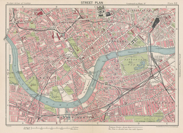
John Bartholomew & SonChelsea, Fulham, Earl's Court, Battersea, and Hammersmith, 19296 x 8 ½ in
15 x 21 cmThe Map House - John Bartholomew & Son, Chelsea, Fulham, Earl's Court, Battersea, and Hammersmith, 1929£ 115.00 -
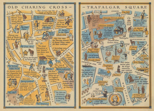
The Map House - J.P. Sayer, Trafalgar Square - Before & After, 1946£ 88.00
-
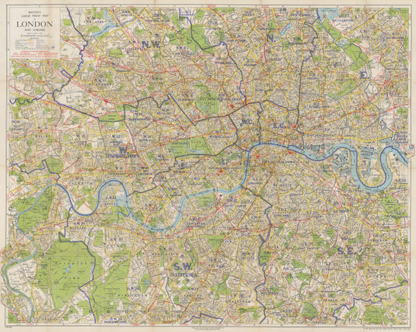
The Map House - George W. Bacon, Bacon's Large-Print Map of London and Suburbs, 1905 c£ 575.00
-
The Map House - George W. Bacon, Paddington, Bayswater, St. John's Wood & Maida Vale, 1886£ 395.00
-
The Map House - Samuel Lewis, A Plan of London and its Environs, 1840 c.£ 750.00
-
The Map House - J.P. Sayer, Kensington Gardens & Hyde Park, 1946£ 115.00
-
The Map House - J.P. Sayer, A Bird's-Eye View of Hyde Park Corner, 1947£ 95.00
-
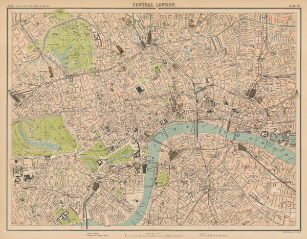
The Map House - J.G. Bartholomew, Central London, 1899£ 345.00
-
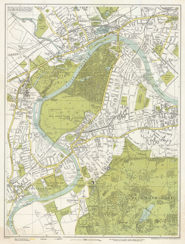
The Map House - Geographia Ltd., Kew, Richmond, Brentford & Twickenham, 1923£ 250.00
-
-
The Map House - George W. Bacon, Bacon's Large-Print Map of London and Suburbs, 1940 c£ 395.00
-
The Map House - Robert Wilkinson, Parthian Empire, 1842£ 125.00
-
The Map House - James Wyld, Map of the Countries lying between Turkey and Burmah, 1839£ 2,450.00
-
The Map House - Rigobert Bonne, Carte De L'Arabie, 1771£ 695.00
-
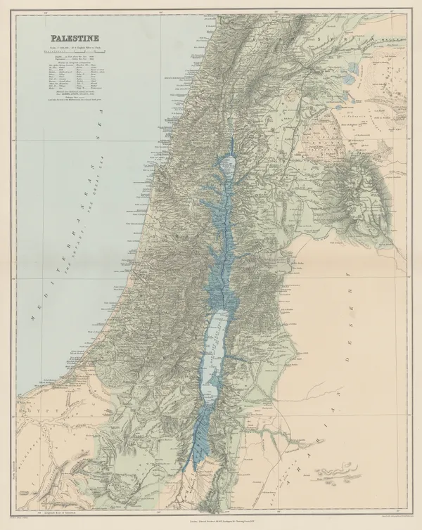
The Map House - Edward Stanford, Palestine, 1896£ 175.00
-
The Map House - Aaron Arrowsmith & Samuel Lewis, Persia, 1812£ 125.00
-
-
The Map House - R. Dolcet, Isla de Menorca, 1950£ 165.00
-
The Map House - Jacques-Nicolas Bellin, Corte - Corsica, 1764£ 165.00
-
The Map House - Jacques-Nicolas Bellin, Plan de la Baye de Calvi, 1764£ 165.00
-
The Map House - R. Dolcet, Mallorca, Menorca & Ibiza, 1950£ 175.00
-
The Map House - Dirección General de Turismo de Baleares, Mallorca Turistica, 1960£ 575.00
-
The Map House - Willem & Jan Blaeu, Middlesex, or North & West London, 1650 c.£ 725.00
-
The Map House - Frederick Jackson, Nottingham, 1861£ 750.00
-
The Map House - Samuel Lewis, Northumberland, 1842£ 65.00
-
The Map House - Alden & Co, Plan of Oxford, 1890 c.£ 275.00
-
The Map House - Petrus Bertius, America Meridionalis, 1616£ 395.00
-
The Map House - Jan Blaeu, Venezuela, 1650 c.£ 1,750.00
-
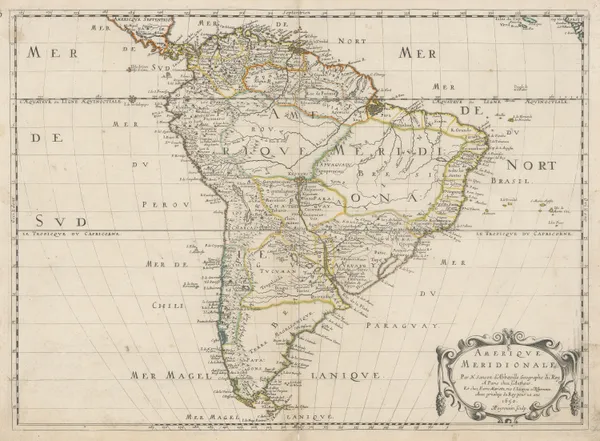
The Map House - Nicolas & Guillaume Sanson, South America, 1650£ 1,450.00
-
The Map House - James Cowles Prichard, Ethnographic Map of South America, 1861£ 450.00
-
The Map House - Aaron Arrowsmith & Samuel Lewis, Colombia & Ecuador, 1812£ 145.00
-
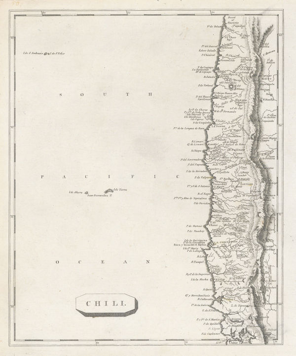
The Map House - Aaron Arrowsmith & Samuel Lewis, Chile, 1812£ 195.00
-
The Map House - Royal Geographical Society (RGS), Map of Iceland, 1882£ 195.00
-
The Map House - John Bartholomew & Son, Estonia, Latvia & Lithuania, 1922£ 125.00
-
The Map House - W. & A.K. Johnston, Johnston's County Map of Lanarkshire, 1841£ 850.00
-
-
The Map House - Eugène Andriveau-Goujon, East & Southeast Asia, 1860£ 885.00
-
The Map House - Georges-Louis Le Rouge, La Chine, 1745 c.£ 325.00
-
The Map House - Edward Stanford, Map of the Far East, 1941£ 1,450.00
-
The Map House - Sanyu Takashiba, Japan, 1850 c£ 2,250.00
-
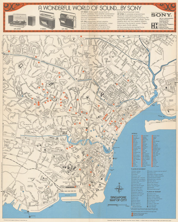
The Map House - Singapore Tourism Promotion Board (STPB), Singapore, 1975 c.£ 875.00
-
The Map House - Jacques-Nicolas Bellin, Thailand, Vietnam, Laos, Cambodia & Myanmar, 1764£ 745.00
-
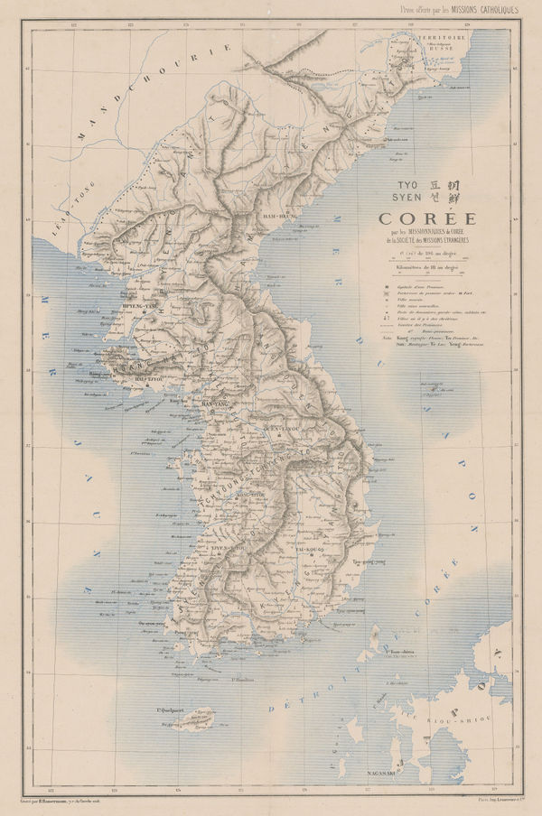
The Map House - R. P. Carceri, Korea, 1872£ 1,950.00
-
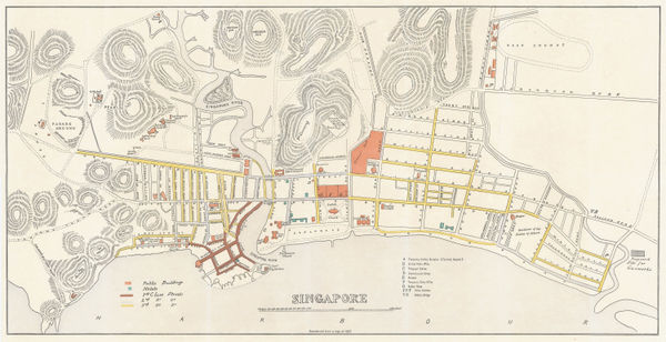
The Map House - Jules Moniot, Singapore, 1950 c£ 545.00
-
The Map House - Aaron Arrowsmith & Samuel Lewis, Japan, 1812£ 275.00
-
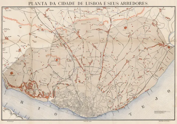
The Map House - M. Grima, Lisbon and its Environs, 1888£ 645.00
-
The Map House - George W. Bacon, Eastbourne, 1920 c.£ 95.00
-
The Map House - Edward Stanford, Istanbul & the Bosporus, 1878£ 78.00
-
The Map House - Samuel Purchas, Anatolia, 1625£ 345.00
-
The Map House - Enciclopedia Segui, Istanbul, 1910 c.£ 145.00
-
The Map House - Jacques-Nicolas Bellin, Türkiye (Asia Minor), 1764£ 225.00
-
The Map House - Munim Eser, Tourist Plan of Istanbul, 1960 c.£ 425.00
-
The Map House - Antonio Zatta, Mexico, Texas & the Southern USA, 1785£ 795.00
-
The Map House - Henry William Blair, New York City's Drinking Problem, 1888£ 1,250.00
-
The Map House - Oren Arnold, Map of the United States as Arizonans See It, 1952£ 675.00
-
The Map House - George Cram, Idaho, 1900 c.£ 185.00
-
The Map House - E.J. Schaeffer & Associates, The Florida Keys & Key West, 1965 c.£ 245.00
-
The Map House - Enciclopedia Segui, Chicago, 1910 c.£ 125.00
-
The Map House - Rand, McNally & Co., Arizona, 1892£ 275.00
-
The Map House - Kenyon Printing & Mfg. Co., Map of Colorado, 1902£ 275.00
-
The Map House - Matthew Carey, The State of Maryland, 1802£ 1,350.00
-
The Map House - Rand, McNally & Co., New Commercial Atlas Map of Arkansas, 1920 c.£ 245.00
-
The Map House - Rand, McNally & Co., Colorado, 1904£ 395.00
-
The Map House - Rand, McNally & Co., Arizona, 1912£ 475.00
-
The Map House - John L. Lynde, Street Map of the City of Pasadena, 1954£ 495.00
-
The Map House - Rand, McNally & Co., West Virginia, 1907£ 175.00
-
The Map House - Aaron Arrowsmith & Samuel Lewis, New York State, 1812£ 345.00
-
The Map House - Aaron Arrowsmith & Samuel Lewis, South Carolina, 1812£ 345.00
-
The Map House - Aaron Arrowsmith & Samuel Lewis, Tennessee, 1812£ 375.00
-
The Map House - Jacques-Nicolas Bellin, Georgia & South Carolina, 1764£ 595.00
-
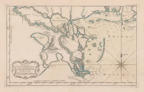
The Map House - Jacques-Nicolas Bellin, Mouth of the Mississippi River, 1764£ 1,250.00
-
The Map House - Jacques-Nicolas Bellin, The Carolinas, 1764£ 1,250.00
-
The Map House - Jacques-Nicolas Bellin, The Great Lakes, 1764£ 2,250.00
-
The Map House - Aaron Arrowsmith & Samuel Lewis, Vermont, 1812£ 295.00
-
The Map House - Aaron Arrowsmith & Samuel Lewis, Rhode Island, 1812£ 275.00
-
The Map House - Aaron Arrowsmith & Samuel Lewis, Eastern United States, 1812£ 395.00
-
The Map House - Aaron Arrowsmith & Samuel Lewis, Pennsylvania, 1812£ 275.00
-
The Map House - Aaron Arrowsmith & Samuel Lewis, New Hampshire, 1812£ 295.00
-
-
The Map House - Nicolas & Guillaume Sanson, Audience de Mexico, 1692£ 345.00
-
The Map House - Jacques-Nicolas Bellin, Carte de l'Isle de la Martinique, 1758£ 115.00
-
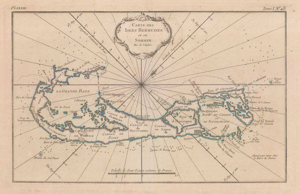
The Map House - Jacques-Nicolas Bellin, Map of Bermuda, 1764£ 1,250.00
-
The Map House - Jacques-Nicolas Bellin, Lesser Antilles, 1764£ 495.00
-
The Map House - Jacques-Nicolas Bellin, Saint Thomas, U.S. Virgin Islands, 1764£ 795.00
-
The Map House - John Bartholomew & Son, Mexico & Central America, 1922£ 125.00
-
The Map House - Jacques-Nicolas Bellin, Turks & Caicos and Southern Bahamas, 1764£ 595.00
-
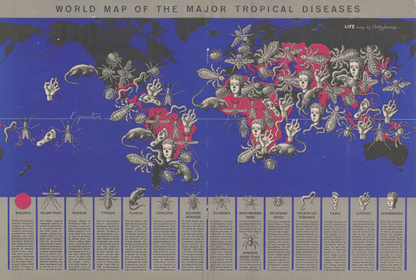
The Map House - Boris Artzybasheff, World Map of the Major Tropical Diseases, 1944£ 525.00
-
-
-
-
The Map House - Enciclopedia Segui, World Shipping Routes, 1910 c.£ 115.00
-
The Map House - Enciclopedia Segui, Climate Zones & Ocean Currents, 1910 c.£ 85.00
-
The Map House - Jacques-Nicolas Bellin, Carte Reduite du Globe Terrestre, 1764£ 495.00