New Maps / May 2026

  • Royal Geographical Society (RGS), Boundaries in East Africa, 1926
    Royal Geographical Society (RGS)
    Boundaries in East Africa, 1926
    8 ½ x 7 ½ in
    22 x 19 cm
    The Map House - Royal Geographical Society (RGS), Boundaries in East Africa, 1926
    £ 145.00
  • Geographical Section, General Staff (GSGS), Tribal Map of East Africa, 1953
    Geographical Section, General Staff (GSGS)
    Tribal Map of East Africa, 1953
    24 x 32 in
    61 x 81 cm
    The Map House - Geographical Section, General Staff (GSGS), Tribal Map of East Africa, 1953
    £ 795.00
  • Justus Perthes, Comoros, 1890
    Justus Perthes
    Comoros, 1890
    8 ½ x 10 in
    21 x 26 cm
    The Map House - Justus Perthes, Comoros, 1890
    £ 125.00
  • Justus Perthes, Source of the Nile, 1863
    Justus Perthes
    Source of the Nile, 1863
    10 x 8 in
    26 x 20 cm
    The Map House - Justus Perthes, Source of the Nile, 1863
    £ 125.00
  • Arbuckle Brothers Company, Central Africa, 1889
    Arbuckle Brothers Company
    Central Africa, 1889
    3 x 5 in
    8 x 11 cm
    The Map House - Arbuckle Brothers Company, Central Africa, 1889
    £ 95.00
  • Arbuckle Brothers Company, Cape Colony South Africa, 1889
    Arbuckle Brothers Company
    Cape Colony South Africa, 1889
    3 x 5 in
    8 x 13 cm
    The Map House - Arbuckle Brothers Company, Cape Colony South Africa, 1889
    £ 175.00
  • Arbuckle Brothers Company, Morocco, 1889
    Arbuckle Brothers Company
    Morocco, 1889
    3 x 5 in
    8 x 13 cm
    The Map House - Arbuckle Brothers Company, Morocco, 1889
    £ 115.00
  • John Tallis, Cape Colony, 1851
    John Tallis
    Cape Colony, 1851
    10 x 13 in
    26 x 33 cm
    The Map House - John Tallis, Cape Colony, 1851
    £ 395.00
  • Abraham Ortelius, Africae Tabula Nova, 1595 c.
    Abraham Ortelius
    Africae Tabula Nova, 1595 c.
    15 1/2 x 20 1/2 in
    39 x 52 cm
    The Map House - Abraham Ortelius, Africae Tabula Nova, 1595 c.
    £ 4,250.00
  • Samuel Augustus Mitchell, North America, 1846 c
    Samuel Augustus Mitchell
    North America, 1846 c
    10 ½ x 8 ½ in
    27 x 21 cm
    The Map House - Samuel Augustus Mitchell, North America, 1846 c
    £ 175.00
  • Joshua Archer, Asia, 1833
    Joshua Archer
    Asia, 1833
    6 x 9 in
    15 x 23 cm
    The Map House - Joshua Archer, Asia, 1833
    £ 55.00
  • Justus Perthes, Southern Alps of New Zealand, 1863
    Justus Perthes
    Southern Alps of New Zealand, 1863
    10 x 8 ½ in
    26 x 21 cm
    The Map House - Justus Perthes, Southern Alps of New Zealand, 1863
    £ 125.00
  • Justus Perthes, Australia's Northwest Coast, 1881
    Justus Perthes
    Australia's Northwest Coast, 1881
    8 x 10 in
    20 x 26 cm
    The Map House - Justus Perthes, Australia's Northwest Coast, 1881
    £ 95.00
  • Arbuckle Brothers Company, Australia, 1889
    Arbuckle Brothers Company
    Australia, 1889
    3 x 5 in
    8 x 13 cm
    The Map House - Arbuckle Brothers Company, Australia, 1889
    £ 185.00
  • Arbuckle Brothers Company, Dominion of Canada, 1889
    Arbuckle Brothers Company
    Dominion of Canada, 1889
    3 x 5 in
    8 x 13 cm
    The Map House - Arbuckle Brothers Company, Dominion of Canada, 1889
    £ 115.00
  • Arbuckle Brothers Company, Newfoundland, 1889
    Arbuckle Brothers Company
    Newfoundland, 1889
    3 x 5 in
    8 x 13 cm
    The Map House - Arbuckle Brothers Company, Newfoundland, 1889
    £ 95.00
  • Richard Anthony Proctor, MAP VII., 1896
    Richard Anthony Proctor
    MAP VII., 1896
    10 x 8 1/2 in
    26 x 21 cm
    The Map House - Richard Anthony Proctor, MAP VII., 1896
    £ 95.00
  • Ethelbert William Bullinger, XXXVIII. Argo (The Ship), 1921
    Ethelbert William Bullinger
    XXXVIII. Argo (The Ship), 1921
    7 ½ x 4 ½ in
    19 x 12 cm
    The Map House - Ethelbert William Bullinger, XXXVIII. Argo (The Ship), 1921
    £ 85.00
  • Ethelbert William Bullinger, XIX. Pegasus (The Winged Horse), 1921
    Ethelbert William Bullinger
    XIX. Pegasus (The Winged Horse), 1921
    4 ½ x 7 ½ in
    12 x 19 cm
    The Map House - Ethelbert William Bullinger, XIX. Pegasus (The Winged Horse), 1921
    £ 85.00
  • Justus Perthes, Montenegro, 1894
    Justus Perthes
    Montenegro, 1894
    10 x 8 in
    26 x 20 cm
    The Map House - Justus Perthes, Montenegro, 1894
    £ 145.00
  • John Cary, Map of Devon from the Best Authorities, 1805
    John Cary
    Map of Devon from the Best Authorities, 1805
    17 ½ x 19 in
    44 x 48 cm
    The Map House - John Cary, Map of Devon from the Best Authorities, 1805
    £ 325.00
  • Stanley Turner, Invasion Map of Fortress Europe, 1944
    Stanley Turner
    Invasion Map of Fortress Europe, 1944
    20 x 26 in
    51 x 66 cm
    The Map House - Stanley Turner, Invasion Map of Fortress Europe, 1944
    £ 325.00
  • Louis Larmat, "Les vins de Bourgogne" - La Côte de Beaune, 1942
    Louis Larmat
    "Les vins de Bourgogne" - La Côte de Beaune, 1942
    47 x 17 ½ in
    120 x 44 cm
    The Map House - Louis Larmat, "Les vins de Bourgogne" - La Côte de Beaune, 1942
    £ 1,650.00
  • Nicolas de Fer, Paris, 1729
    Nicolas de Fer
    Paris, 1729
    18 ½ x 22 in
    47 x 56 cm
    The Map House - Nicolas de Fer, Paris, 1729
    £ 950.00
  • Monaco Tourism Office, Principality of Monaco, 1943
    Monaco Tourism Office
    Principality of Monaco, 1943
    16 x 35 in
    40 x 89 cm
    The Map House - Monaco Tourism Office, Principality of Monaco, 1943
    £ 1,450.00
  • Arbuckle Brothers Company, France, 1889
    Arbuckle Brothers Company
    France, 1889
    3 x 5 in
    8 x 13 cm
    The Map House - Arbuckle Brothers Company, France, 1889
    £ 125.00
  • Thomas Jenner, The North Part of England and the South Part of Scotland, 1688
    Thomas Jenner
    The North Part of England and the South Part of Scotland, 1688
    15 x 20 in
    38 x 51 cm
    The Map House - Thomas Jenner, The North Part of England and the South Part of Scotland, 1688
    £ 595.00
  • Arbuckle Brothers Company, Greece, 1889
    Arbuckle Brothers Company
    Greece, 1889
    3 x 5 in
    8 x 13 cm
    The Map House - Arbuckle Brothers Company, Greece, 1889
    £ 135.00
  • Robert Wilkinson, Ancient Greece, 1842
    Robert Wilkinson
    Ancient Greece, 1842
    12 x 9 ½ in
    30 x 24 cm
    The Map House - Robert Wilkinson, Ancient Greece, 1842
    £ 125.00
  • Arbuckle Brothers Company, Ireland, 1889
    Arbuckle Brothers Company
    Ireland, 1889
    3 x 5 in
    8 x 13 cm
    The Map House - Arbuckle Brothers Company, Ireland, 1889
    £ 175.00
  • Heinrich Berann, Capri, 1965
    Heinrich Berann
    Capri, 1965
    12 x 13 in
    30 x 33 cm
    The Map House - Heinrich Berann, Capri, 1965
    £ 195.00
  • Arbuckle Brothers Company, Italy, 1889
    Arbuckle Brothers Company
    Italy, 1889
    3 x 5 in
    8 x 13 cm
    The Map House - Arbuckle Brothers Company, Italy, 1889
    £ 115.00
  • Giovanni De Agostini, Abruzzo e Molise, 1958
    Giovanni De Agostini
    Abruzzo e Molise, 1958
    8 1/2 x 10 1/2 in
    22 x 27 cm
    The Map House - Giovanni De Agostini, Abruzzo e Molise, 1958
    £ 125.00
  • William Swire, Liverpool and its environs, 1824
    William Swire
    Liverpool and its environs, 1824
    17 x 21 ½ in
    43 x 54 cm
    The Map House - William Swire, Liverpool and its environs, 1824
    £ 495.00
  • George W. Bacon, Bacon's Gem Map of London and its Suburbs, 1912 c.
    George W. Bacon
    Bacon's Gem Map of London and its Suburbs, 1912 c.
    22 x 23 ½ in
    56 x 60 cm
    The Map House - George W. Bacon, Bacon's Gem Map of London and its Suburbs, 1912 c.
    £ 425.00
  • J.G. Bartholomew, Kew, Richmond and Hampton Court, 1929
    J.G. Bartholomew
    Kew, Richmond and Hampton Court, 1929
    8 ½ x 6 in
    21 x 15 cm
    The Map House - J.G. Bartholomew, Kew, Richmond and Hampton Court, 1929
    £ 75.00
  • George W. Bacon, Notting Hill, Holland Park, Shepherds Bush & Kensal Green, 1885 c.
    George W. Bacon
    Notting Hill, Holland Park, Shepherds Bush & Kensal Green, 1885 c.
    23 x 15 in
    59 x 38 cm
    The Map House - George W. Bacon, Notting Hill, Holland Park, Shepherds Bush & Kensal Green, 1885 c.
    £ 595.00
  • Claudius Ptolemy, Arabia, 1482
    Claudius Ptolemy
    Arabia, 1482
    11 ½ x 21 ½ in
    29 x 54 cm
  • George Philip & Son Ltd., Middle East, 1882
    George Philip & Son Ltd.
    Middle East, 1882
    12 x 17 in
    31 x 43 cm
  • George Philip & Son Ltd., Palestine, 1882
    George Philip & Son Ltd.
    Palestine, 1882
    17 x 12 in
    43 x 31 cm
    The Map House - George Philip & Son Ltd., Palestine, 1882
    £ 145.00
  • Justus Perthes, Northwest Arabia, 1881
    Justus Perthes
    Northwest Arabia, 1881
    10 x 8 ½ in
    26 x 21 cm
    The Map House - Justus Perthes, Northwest Arabia, 1881
    £ 125.00
  • Arbuckle Brothers Company, Iran (Persia), 1889
    Arbuckle Brothers Company
    Iran (Persia), 1889
    3 x 5 in
    8 x 13 cm
    The Map House - Arbuckle Brothers Company, Iran (Persia), 1889
    £ 135.00
  • James Belgrave, The City of Manama, 1965
    James Belgrave
    The City of Manama, 1965
    28 ½ x 18 in
    73 x 46 cm
    The Map House - James Belgrave, The City of Manama, 1965
    £ 975.00
  • Robert Wilkinson, Palaestina seu Terra Sancta, 1806
    Robert Wilkinson
    Palaestina seu Terra Sancta, 1806
    11 x 8 ½ in
    28 x 22 cm
    The Map House - Robert Wilkinson, Palaestina seu Terra Sancta, 1806
    £ 275.00
  • Salvador Sala, Balearic Islands, 1850 c
    Salvador Sala
    Balearic Islands, 1850 c
    14 x 17 in
    36 x 43 cm
    The Map House - Salvador Sala, Balearic Islands, 1850 c
    £ 395.00
  • J.G. Bartholomew, Plan of Amsterdam, 1893
    J.G. Bartholomew
    Plan of Amsterdam, 1893
    7 x 8 in
    18 x 20 cm
    The Map House - J.G. Bartholomew, Plan of Amsterdam, 1893
    £ 98.00
  • Christopher Saxton & William Kip, Northamtoniae Comitatvs Descriptio in Qvo Coritani Olim Insedervnt, 1637
    Christopher Saxton & William Kip
    Northamtoniae Comitatvs Descriptio in Qvo Coritani Olim Insedervnt, 1637
    11 ½ x 14 in
    29 x 36 cm
    The Map House - Christopher Saxton & William Kip, Northamtoniae Comitatvs Descriptio in Qvo Coritani Olim Insedervnt, 1637
    £ 225.00
  • Teofil Szumanski, Poland , 1919
    Teofil Szumanski
    Poland , 1919
    22 x 24 in
    56 x 61 cm
    The Map House - Teofil Szumanski, Poland , 1919
    £ 1,250.00
  • Central Geographical Office, Poland, 1966
    Central Geographical Office
    Poland, 1966
    56 x 64 in
    142 x 163 cm
    The Map House - Central Geographical Office, Poland, 1966
    £ 950.00
  • Tymoteusz Sawicki, Warsaw, 1930
    Tymoteusz Sawicki
    Warsaw, 1930
    25 x 20 in
    63 x 51 cm
    The Map House - Tymoteusz Sawicki, Warsaw, 1930
    £ 495.00
  • A. Povolotski, Kyiv, 1966
    A. Povolotski
    Kyiv, 1966
    21 x 29 in
    53 x 74 cm
    The Map House - A. Povolotski, Kyiv, 1966
    £ 445.00
  • Arbuckle Brothers Company, Argentina, 1889
    Arbuckle Brothers Company
    Argentina, 1889
    3 x 5 in
    8 x 13 cm
    The Map House - Arbuckle Brothers Company, Argentina, 1889
    £ 145.00
  • Arbuckle Brothers Company, Uruguay, 1889
    Arbuckle Brothers Company
    Uruguay, 1889
    3 x 5 in
    8 x 13 cm
    The Map House - Arbuckle Brothers Company, Uruguay, 1889
    £ 165.00
  • Arbuckle Brothers Company, Bolivia, 1889
    Arbuckle Brothers Company
    Bolivia, 1889
    3 x 5 in
    8 x 13 cm
    The Map House - Arbuckle Brothers Company, Bolivia, 1889
    £ 98.00
  • William Christensen, Copenhagen, 1888
    William Christensen
    Copenhagen, 1888
    17 ½ x 22 in
    45 x 56 cm
    The Map House - William Christensen, Copenhagen, 1888
    £ 395.00
  • Arbuckle Brothers Company, Denmark, 1889
    Arbuckle Brothers Company
    Denmark, 1889
    3 x 5 in
    8 x 13 cm
    The Map House - Arbuckle Brothers Company, Denmark, 1889
    £ 95.00
  • Arbuckle Brothers Company, Scotland, 1889
    Arbuckle Brothers Company
    Scotland, 1889
    3 x 5 in
    8 x 13 cm
    The Map House - Arbuckle Brothers Company, Scotland, 1889
    £ 165.00
  • John Tallis, Scotland, 1851
    John Tallis
    Scotland, 1851
    14 x 10 in
    36 x 25 cm
    The Map House - John Tallis, Scotland, 1851
    £ 425.00
  • Jan Huygen van Linschoten, South East Asia, 1599 c
    Jan Huygen van Linschoten
    South East Asia, 1599 c
    15 ½ x 20 ½ in
    39 x 52 cm
  • Anonymous, Korea, 1960 c
    Anonymous
    Korea, 1960 c
    42 x 28 in
    107 x 71 cm
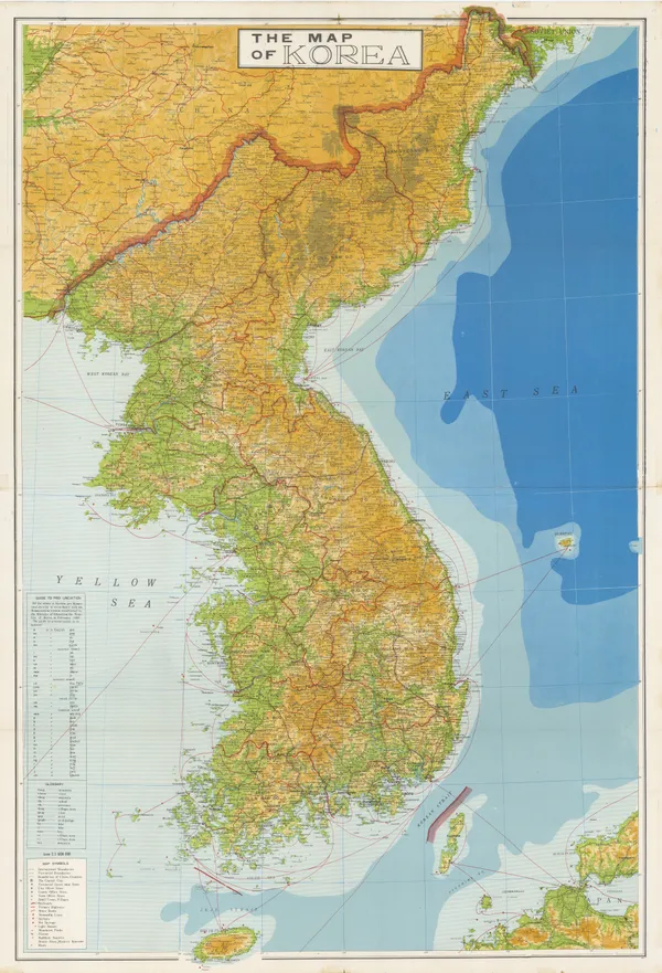
    The Map House - Anonymous, Korea, 1960 c
    £ 595.00
  • Obuchi Yoshikichi, Taiwan, 1939
    Obuchi Yoshikichi
    Taiwan, 1939
    39 ½ x 27 in
    100 x 69 cm
    The Map House - Obuchi Yoshikichi, Taiwan, 1939
    £ 795.00
  • Sagano Hikotaro, Japan, 1889
    Sagano Hikotaro
    Japan, 1889
    20 x 43 ½ in
    51 x 110 cm
    The Map House - Sagano Hikotaro, Japan, 1889
    £ 1,650.00
  • George Philip & Son Ltd., Japan, 1882
    George Philip & Son Ltd.
    Japan, 1882
    17 x 12 in
    43 x 31 cm
    The Map House - George Philip & Son Ltd., Japan, 1882
    £ 145.00
  • Justus Perthes, Tokyo and Environs, 1894
    Justus Perthes
    Tokyo and Environs, 1894
    10 x 8 ½ in
    26 x 21 cm
    The Map House - Justus Perthes, Tokyo and Environs, 1894
    £ 95.00
  • Survey Department of the Federation of Malaya, Map of the Colony of Singapore, 1950
    Survey Department of the Federation of Malaya
    Map of the Colony of Singapore, 1950
    8 x 12 in
    20 x 30 cm
    The Map House - Survey Department of the Federation of Malaya, Map of the Colony of Singapore, 1950
    £ 595.00
  • Isaac Tirion, Nouvelle Carte de l'Empire de la Chine, 1760 c.
    Isaac Tirion
    Nouvelle Carte de l'Empire de la Chine, 1760 c.
    10 x 13 in
    26 x 33 cm
    The Map House - Isaac Tirion, Nouvelle Carte de l'Empire de la Chine, 1760 c.
    £ 925.00
  • Arbuckle Brothers Company, MARCH Empire of Japan, 1889
    Arbuckle Brothers Company
    MARCH Empire of Japan, 1889
    3 x 5 in
    8 x 13 cm
    The Map House - Arbuckle Brothers Company, MARCH Empire of Japan, 1889
    £ 225.00
  • Enciclopedia Segui, Barcelona, 1910 (c.)
    Enciclopedia Segui
    Barcelona, 1910 (c.)
    11 x 17 in
    28 x 43 cm
    The Map House - Enciclopedia Segui, Barcelona, 1910 (c.)
    £ 125.00
  • Joseph Meyer, Vienna, 1844
    Joseph Meyer
    Vienna, 1844
    16 1/2 x 13 in
    42 x 33 cm
    The Map House - Joseph Meyer, Vienna, 1844
    £ 495.00
  • Arbuckle Brothers Company, Austria-Hungary, 1889
    Arbuckle Brothers Company
    Austria-Hungary, 1889
    3 x 4 in
    8 x 10 cm
    The Map House - Arbuckle Brothers Company, Austria-Hungary, 1889
    £ 90.00
  • Arbuckle Brothers Company, Switzerland, 1889
    Arbuckle Brothers Company
    Switzerland, 1889
    3 x 5 in
    7.6 x 12.7 cm
    The Map House - Arbuckle Brothers Company, Switzerland, 1889
    £ 155.00
  • Arbuckle Brothers Company, Türkiye (Turkey), 1889
    Arbuckle Brothers Company
    Türkiye (Turkey), 1889
    3 x 5 in
    8 x 13 cm
    The Map House - Arbuckle Brothers Company, Türkiye (Turkey), 1889
    £ 95.00
  • Nicolas & Guillaume Sanson, Turkey, 1692
    Nicolas & Guillaume Sanson
    Turkey, 1692
    7 ½ x 10 in
    19 x 25 cm
    The Map House - Nicolas & Guillaume Sanson, Turkey, 1692
    £ 285.00
  • Letts & Son, New York City, 1892
    Letts & Son
    New York City, 1892
    13 x 30 in
    33 x 76.2 cm
    The Map House - Letts & Son, New York City, 1892
    £ 695.00
  • Aaron Arrowsmith & Samuel Lewis, Maine, 1812
    Aaron Arrowsmith & Samuel Lewis
    Maine, 1812
    8 ½ x 10 in
    21 x 25 cm
    The Map House - Aaron Arrowsmith & Samuel Lewis, Maine, 1812
    £ 375.00
  • Aaron Arrowsmith & Samuel Lewis, Massachusetts, 1812
    Aaron Arrowsmith & Samuel Lewis
    Massachusetts, 1812
    8 x 10 in
    20 x 25 cm
    The Map House - Aaron Arrowsmith & Samuel Lewis, Massachusetts, 1812
    £ 295.00
  • Aaron Arrowsmith & Samuel Lewis, Ohio, 1812
    Aaron Arrowsmith & Samuel Lewis
    Ohio, 1812
    10 x 8 ½ in
    25 x 21 cm
    The Map House - Aaron Arrowsmith & Samuel Lewis, Ohio, 1812
    £ 325.00
  • Aaron Arrowsmith & Samuel Lewis, Kentucky, 1812
    Aaron Arrowsmith & Samuel Lewis
    Kentucky, 1812
    10 x 8 ½ in
    25 x 21 cm
    The Map House - Aaron Arrowsmith & Samuel Lewis, Kentucky, 1812
    £ 375.00
  • Aaron Arrowsmith & Samuel Lewis, New Jersey, 1812
    Aaron Arrowsmith & Samuel Lewis
    New Jersey, 1812
    10 x 8 ½ in
    25 x 21 cm
    The Map House - Aaron Arrowsmith & Samuel Lewis, New Jersey, 1812
    £ 275.00
  • Aaron Arrowsmith & Samuel Lewis, Maryland, 1812
    Aaron Arrowsmith & Samuel Lewis
    Maryland, 1812
    10 x 8 ½ in
    25 x 21 cm
    The Map House - Aaron Arrowsmith & Samuel Lewis, Maryland, 1812
    £ 345.00
  • Aaron Arrowsmith & Samuel Lewis, North Carolina, 1812
    Aaron Arrowsmith & Samuel Lewis
    North Carolina, 1812
    10 x 8 ½ in
    25 x 21 cm
    The Map House - Aaron Arrowsmith & Samuel Lewis, North Carolina, 1812
    £ 325.00
  • Aaron Arrowsmith & Samuel Lewis, Virginia, 1812
    Aaron Arrowsmith & Samuel Lewis
    Virginia, 1812
    10 x 8 ½ in
    25 x 21 cm
    The Map House - Aaron Arrowsmith & Samuel Lewis, Virginia, 1812
    £ 375.00
  • Arbuckle Brothers Company, Illinois, 1889
    Arbuckle Brothers Company
    Illinois, 1889
    7.6 x 11.4 cm
    3 x 4 ½ in
    The Map House - Arbuckle Brothers Company, Illinois, 1889
    £ 98.00
  • Arbuckle Brothers Company, Wisconsin, 1889
    Arbuckle Brothers Company
    Wisconsin, 1889
    3 x 5 in
    8 x 13 cm
    The Map House - Arbuckle Brothers Company, Wisconsin, 1889
    £ 98.00
  • Arbuckle Brothers Company, New York State, 1889
    Arbuckle Brothers Company
    New York State, 1889
    3 x 5 in
    8 x 13 cm
    The Map House - Arbuckle Brothers Company, New York State, 1889
    £ 98.00
  • Arbuckle Brothers Company, United States, 1889
    Arbuckle Brothers Company
    United States, 1889
    3 x 5 in
    8 x 13 cm
    The Map House - Arbuckle Brothers Company, United States, 1889
    £ 195.00
  • Arbuckle Brothers Company, Colorado, 1889
    Arbuckle Brothers Company
    Colorado, 1889
    3 x 5 in
    8 x 13 cm
    The Map House - Arbuckle Brothers Company, Colorado, 1889
    £ 195.00
  • Arbuckle Brothers Company, Florida, 1889
    Arbuckle Brothers Company
    Florida, 1889
    3 x 4 ½ in
    8 x 12 cm
    The Map House - Arbuckle Brothers Company, Florida, 1889
    £ 295.00
  • Frederic M. Thrasher, Chicago's Gangland, 1927 c.
    Frederic M. Thrasher
    Chicago's Gangland, 1927 c.
    26 x 18 in
    66 x 46 cm
    The Map House - Frederic M. Thrasher, Chicago's Gangland, 1927 c.
    £ 2,950.00
  • Justus Perthes, Coalfields of the United States, 1875
    Justus Perthes
    Coalfields of the United States, 1875
    10 x 8 in
    26 x 20 cm
    The Map House - Justus Perthes, Coalfields of the United States, 1875
    £ 125.00
  • J. Foster Ashburn, Houston City Map, 1950
    J. Foster Ashburn
    Houston City Map, 1950
    18 ½ x 25 in
    47 x 63 cm
    The Map House - J. Foster Ashburn, Houston City Map, 1950
    £ 495.00
  • Justus Perthes, Chiriquí Province, 1863
    Justus Perthes
    Chiriquí Province, 1863
    8 ½ x 10 in
    21 x 26 cm
    The Map House - Justus Perthes, Chiriquí Province, 1863
    £ 95.00
  • Arbuckle Brothers Company, Central America, 1889
    Arbuckle Brothers Company
    Central America, 1889
    3 x 5 in
    8 x 13 cm
    The Map House - Arbuckle Brothers Company, Central America, 1889
    £ 145.00
  • Arbuckle Brothers Company, Cuba, 1889
    Arbuckle Brothers Company
    Cuba, 1889
    3 x 5 in
    8 x 13 cm
    The Map House - Arbuckle Brothers Company, Cuba, 1889
    £ 295.00
  • Stanley Turner, Dated Events War Map - 26th Edition, 1945
    Stanley Turner
    Dated Events War Map - 26th Edition, 1945
    17 ½ x 39 in
    44 x 99 cm
    The Map House - Stanley Turner, Dated Events War Map - 26th Edition, 1945
    £ 550.00
  • Stanley Turner, Dated Events War Map - 25th Edition, 1945
    Stanley Turner
    Dated Events War Map - 25th Edition, 1945
    17 ½ x 39 in
    44 x 99 cm
    The Map House - Stanley Turner, Dated Events War Map - 25th Edition, 1945
    £ 550.00
  • Stanley Turner, Dated Events War Map - 20th Edition, 1944
    Stanley Turner
    Dated Events War Map - 20th Edition, 1944
    17 ½ x 39 in
    44 x 99 cm
    The Map House - Stanley Turner, Dated Events War Map - 20th Edition, 1944
    £ 550.00
  • Robert Morden, The East Riding of Yorkshire, 1695
    Robert Morden
    The East Riding of Yorkshire, 1695
    14 x 17 in
    36 x 43 cm
    The Map House - Robert Morden, The East Riding of Yorkshire, 1695
    £ 345.00