Edward Stanford
160 x 128 cm
80 x 128 cm (per sheet)
Further images
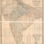
Stanford’s Geographical Establishment was a fledgling cartographical firm established in 1853 and one of their first prestigious, large wall maps was this map of India, first issued in 1857. The large cartouche on the upper right quotes their sources, namely the archives of the British East India Company as well the Surveyor General of the Survey of India. The “other sources” was likely to be the Great Trigonometrical Survey and maps made by railway companies.
Stanford’s map encompasses both political, infrastructure, and geographical elements. The extent of British possessions are shown via colour coding which is explained on the lower part of the map. This same lower part also drily lists a historical number of acquisitions by the British on the sub-continent. This table is entitled “Chronological Table of the Various Acquisitions made to the British Empire in India”. This bland title belies the social, political and geographical changes made to the land during British rule. Two additions have been made to the bottom of the table which do not appear on previous editions of this map: the Indian Mutiny in 1857 and the proclamation of Queen Victoria as Empress of India in 1858.
The map also lists much of the infrastructural effort made by the East India Company to unite the disparate regions of India; primarily through the railways. Although completed sections the lines are still fairly limited by this time, they are marked with red lines. Sanctioned railways which had not yet been completed are marked with dashed lines. Other infrastructure changes include the introduction of Post Offices and the conversion of the Great Trunk Road from a dirt track to a hard surface road.
Several interesting insets are present on the map. Two are schematic distance charts centered on Bombay and Madras recording the mileage between those two important centres and other great cities in India. The lower right shows the newly acquired territories of the Company after the Second Anglo Burmese War of 1852-3.
The map was highly successful, with at least two previous editions in 1857 and 1858, although there were likely to have been more editions after 1863 as well. As usual with Stanford, each edition was meticulously updated to reflect the political changes of the day.
Original hand-colour. Folded. [IC2949]


