Victor Tanasescu
154 x 206 cm
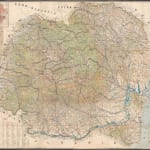
This monumental wall map of Romania was published in 1925 to display and celebrate the country's enlarged borders after the First World War, having gained control of Bessarabia, Bukovina and Transylvania. Known as 'Greater Romania', these borders represent the largest territorial extent ever achieved by Romania. Territorial concessions to Hungary and the Soviet Union in the 1930s and 1940s created the modern shape of Romania we recognize today.
The mapmaker, Colonel Victor Tanasescu, was a cartographer for the Romanian Army who had risen all the way from the rank of private to colonel on the back of his aptitude for cartography and his ability to produce excellent maps very quickly in difficult conditions. This is the only commercially produced map we have been able to identify by Tanasescu - all of his other work was done on behalf of the Romanian army. Tanasescu was forced to become a military reservist in January 1926 at the age of 58, so this map may have been an attempt to establish a new life for himself as a commercial mapmaker in retirement.
Its ambitious size and scale alone make it a masterpiece of cartography and the detail is also excellent. All major roads are marked with distances between towns given in miles. Railways and railway stations are shown on the map, as are mines, oil fields, and factories. The map even notes which minerals are produced by each mine.
Three small inset maps show the city of Bucharest, Europe, and the ethnography of Romania (only indicating whether Romanians or 'others' were the dominant ethnic group in each region).
Printed colour. [CEU2301]


