Philippe Buache
Double Hemisphere World Map, 1745
17 x 26 in
43 x 66 cm
43 x 66 cm
WLD4807
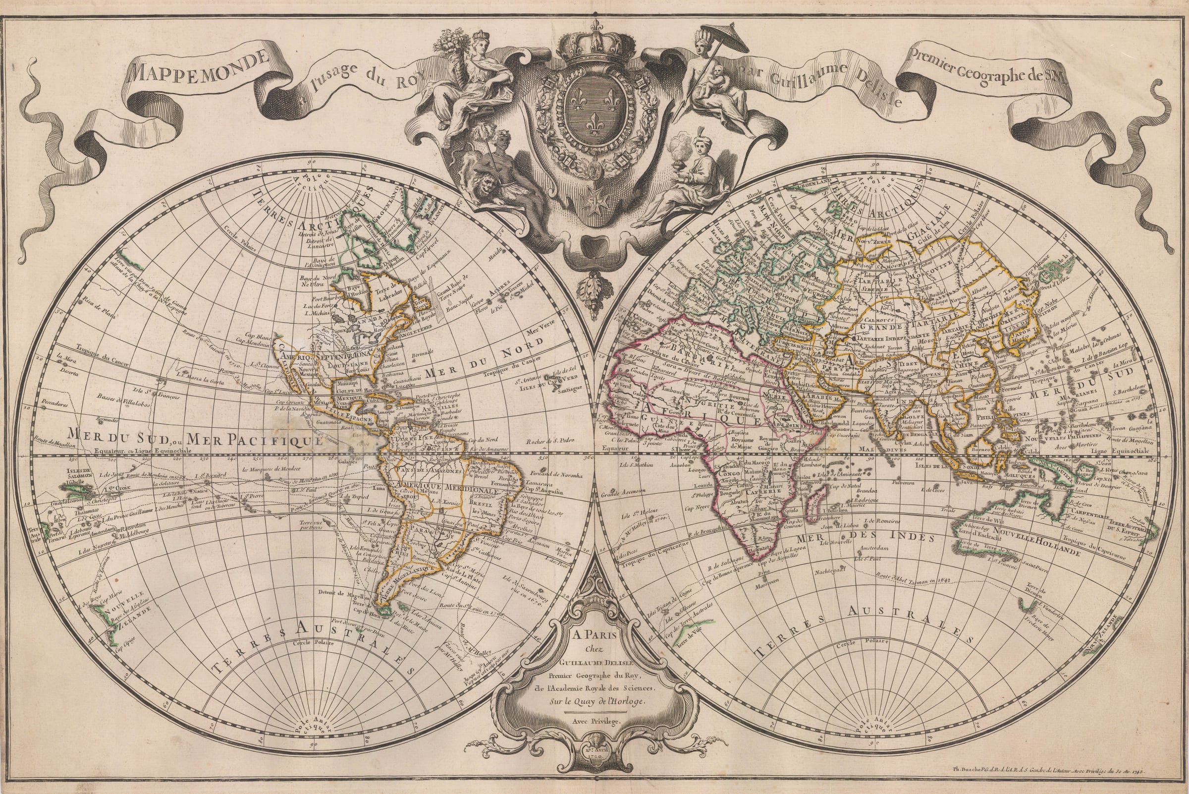
Double hemisphere map of the world by from Guillaume de L’Isle, cited as the first scientific cartographer. De L’Isle epitomised the French scientific school of map making. Although it was...
Double hemisphere map of the world by from Guillaume de L’Isle, cited as the first scientific cartographer.
De L’Isle epitomised the French scientific school of map making. Although it was pioneered by Nicolas Sanson fifty years earlier, it was de L’Isle who cemented this approach which became prevalent in the 18th century and is often called the French School.
The first model for this map was published in 1700 but was almost immediately subject to revision and augmentation. By 1720, the changes became so pronounced that a new plate had to be engraved. The fundamental model remained the same, with the world presented as a double hemisphere and with the seas containing a collection of the routes of some of the most influential explorers to that date. These included Magellan, Tasman and Alvaro de Mendana among others. However, there were several changes between the routes shown on the first and second issues. For example, the early publication shows Chevalier de Chaumont’s route to Thailand, while this is omitted on the later map. Conversely, Edmund Halley’s route in the South Seas near South America is not shown on the earlier map but does appear on this example.
Geographically, de L’Isle reflects many of the beliefs of the time but also challenges others. This is particularly so in the case of California, which is now firmly attached to the North American mainland instead of being portrayed as an island. However, a tiny line appears north of the peninsula, hinting at an interior waterway heading east, yet another wishful feature for the existence of the Northwest Passage. On the other side of the Pacific, Japan is now strongly attached to the continent of Asia, via the mythical land of Yeco, or Yedso, later identified as the island of Hokkaido. The Pacific Northwest of America is left as unknown; the shape of Africa has been changed; the position of the Solomon Islands has now been changed dramatically. These have now been moved to just west of the Santa Cruz Islands. In the previous map, they were several hundred miles east of Santa Cruz.
The aesthetic design of the map has also been changed. The title of the map is now on a ribbon scroll on the upper part of the map while the central cartouche is purely pictorial, showing four figures representing the continents around a large armorial shield bearing the coat of arms of France. Previously, this ribbon advertised de L’Isle’s “New Introduction to Geography” while the central cartouche bore the title of the map. The lower cartouche, with the imprint remains the same.
This example of the map is a posthumous edition by Philip Buache issued in 1745. It seems to have been an unaltered re-issue with the exception of the addition of Buache’s name and the new date on the lower right. Original colour. [WLD4807]