-
 Royal Geographical Society (RGS), Dr. Barth's Route from Tin-Tellust to Agadez, 1860 c.£ 185.00
 -
Justus Perthes, Algeria, Tunisia & Libya, 1863£ 65.00
-
Justus Perthes, Northern Morocco, 1865£ 68.00
-
Alexandre Vuillemin, Folding map of Algeria, 1871£ 295.00
-
Justus Perthes, French military expeditions in Morocco, 1872£ 68.00
-
Carl Muller, North Africa coast during the Classical period, 1873£ 50.00
-
Justus Perthes, Expeditions in the Libyan Desert, 1875£ 185.00
-
Justus Perthes, A Proposed Trans-Saharan Railway, 1877£ 72.00
-
North Africa or Barbary - Tunis and Part of Tripoli, 1879Society for the Diffusion of Useful Knowledge (SDUK)Series: LondonSociety for the Diffusion of Useful Knowledge (SDUK), North Africa or Barbary - Tunis and Part of Tripoli, 1879£ 98.00
-
North Africa or Barbary - Parts of Egypt and Tripoli, 1879Society for the Diffusion of Useful Knowledge (SDUK)Series: LondonSociety for the Diffusion of Useful Knowledge (SDUK), North Africa or Barbary - Parts of Egypt and Tripoli, 1879£ 98.00
-
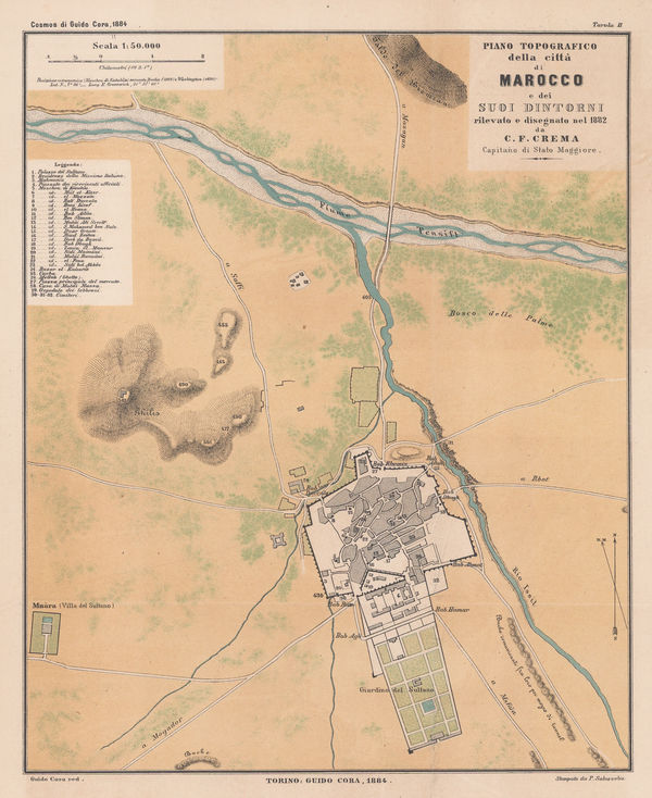
Guido Cora, Italian city plan of Marrakech, 1884£ 325.00
-
A. Simon, Algier. (1886), 1886£ 175.00
-
A. Simon, Mostaganem. (1886), 1886£ 62.00
-
A. Simon, Tunis et ses Abords, 1888£ 175.00
-
Royal Geographical Society (RGS), Northwest Morocco showing desert tribes, 1889£ 95.00
-
Royal Geographical Society (RGS), Map of South Western Morocco, 1889£ 45.00
-
Arbuckle Brothers Company, Morocco, 1889£ 115.00
-
J. Migeon, Algeria, 1890 c.£ 48.00
-
Letts & Son, Algeria, 1892£ 52.00
-
Sketch Maps Illustrating the Physical and Political Geography of Algeria, 1894Scottish Geographical Society (SGS)Series: EdinburghScottish Geographical Society (SGS), Sketch Maps Illustrating the Physical and Political Geography of Algeria, 1894£ 58.00
-
A Map of parts of Gharian, Tarhuna, and M'Salata (Tripoli), 1897Royal Geographical Society (RGS)Series: LondonRoyal Geographical Society (RGS), A Map of parts of Gharian, Tarhuna, and M'Salata (Tripoli), 1897£ 345.00
-
Royal Geographical Society (RGS), Sketch Map of Southern Tunis, 1898£ 62.00
-
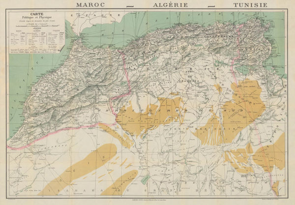
Garnier Frères, Morocco, Algeria & Tunisia, 1900 c.£ 195.00
-
Edward Hertslet, Western Sahara and Mauritania border, 1909£ 48.00
-
Karl Baedeker, Carthage, 1911£ 44.00
-
Karl Baedeker, Tunis, 1911£ 38.00
-
Karl Baedeker, Algiers, 1911£ 38.00
-
Karl Baedeker, Algeria, Tunisia & Libya, 1911£ 38.00
-
Louis Gentil, Geological map of Morocco, 1920£ 945.00
-
Service Géographique de l'Armée, Relief map of Morocco, 1920 c.£ 250.00
-
Jules Chaure, Tourist Map of Casablanca, Morocco, 1920 c.£ 445.00
-
Service Géographique de l'Armée, Southern Morocco, 1924£ 225.00
-
E. Toutey, Folding wall map of Morocco, 1925 c.£ 975.00
-
Cartes Tarides, Vintage folding map of Morocco, 1926 c.£ 545.00
-
Service Géographique de l'Armée, Folding vintage map of Morocco, 1930£ 375.00
-
Service Géographique de l'Armée, Vintage map of Marrakesh, 1930£ 475.00
-
Cartes Tarides, Morocco based on French army surveys, 1930 c.£ 595.00
-
Editions France Afrique, Vintage folding plan of Marrakesh, 1930 c.£ 845.00
-
Service Géographique de l'Armée, Vintage map of Western Morocco, 1932£ 325.00
-
Karl Baedeker, Miniature plan of Algiers, 1934£ 48.00
-
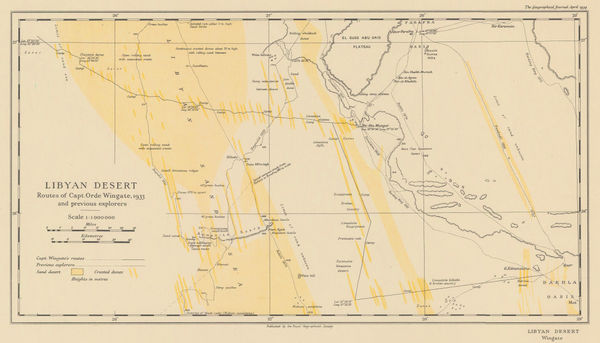
Royal Geographical Society (RGS), Orde Wingate's Egypt Expedition, 1934£ 175.00
-
Royal Geographical Society (RGS), Egypt, Libya, and Sudan Boundary Map, 1935£ 58.00
-
Jean Gaston Mantel, Vintage pictorial map of Morocco, 1958£ 575.00
-
Anonymous, Marrakech, 1960 c.£ 345.00


Page
2
of 2