-
 W. & A.K. Johnston, North Polar Chart, 1912 c£ 225.00
 -
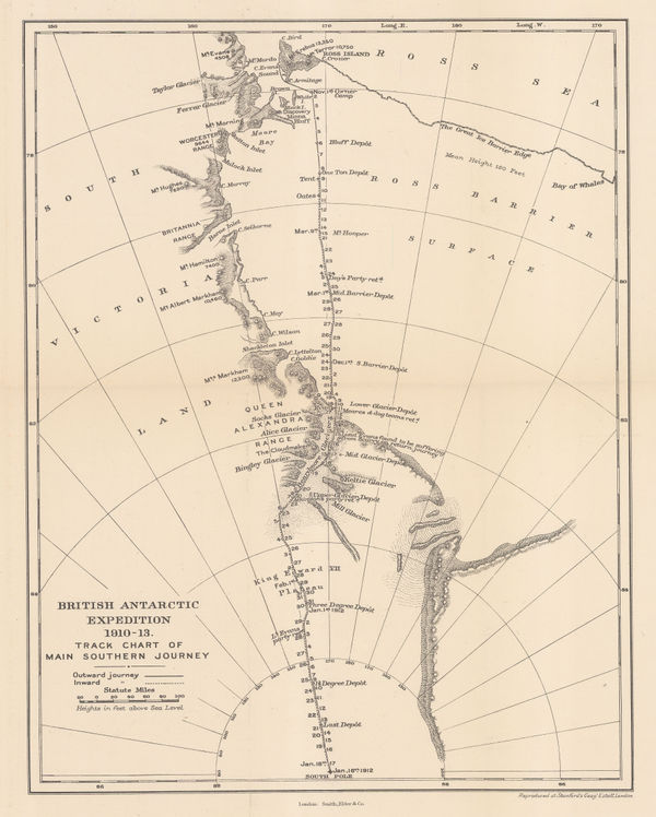
British Antarctic Expedition 1910-13. Track chart of the main southern journey, 1913Edward StanfordSeries: LondonEdward Stanford, British Antarctic Expedition 1910-13. Track chart of the main southern journey, 1913£ 450.00
-
Preliminary Chart showing the Deep Sea Soundings taken on board the 'Aurora' during the 1st and 2nd years work of the Australasian Antarctic Expedition, 1913Royal Geographical Society (RGS)Series: LondonRoyal Geographical Society (RGS), Preliminary Chart showing the Deep Sea Soundings taken on board the 'Aurora' during the 1st and 2nd years work of the Australasian Antarctic Expedition, 1913£ 600.00
-
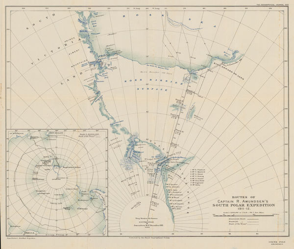
Routes of Captain R. Amundsen's South Polar Expedition 1911-1912, 1913Royal Geographical Society (RGS)Series: LondonRoyal Geographical Society (RGS), Routes of Captain R. Amundsen's South Polar Expedition 1911-1912, 1913£ 4,950.00
-
Edward Stanford, Sketch Map of Mount Erebus, 1913£ 150.00
-
Sketch Map to Illustrate Einar Mikkelsen's Expedition to North East Greenland 1909-12, 1913Royal Geographical Society (RGS)Series: LondonRoyal Geographical Society (RGS), Sketch Map to Illustrate Einar Mikkelsen's Expedition to North East Greenland 1909-12, 1913£ 88.00
-
George Philip & Son Ltd., The Polar Regions, 1913 c.£ 395.00
-
British Admiralty, Heroic Age map of the Ross Sea & Ross Ice Shelf, 1914£ 4,500.00
-
Australasian Antarctic Expedition - King George V Land, 1914Royal Geographical Society (RGS)Series: LondonRoyal Geographical Society (RGS), Australasian Antarctic Expedition - King George V Land, 1914£ 2,450.00
-
Australasian Antarctic Expedition, 1911 - 14. Queen Mary Land, Showing the tracking of the Sledging Parties from the Main Base, 1914Royal Geographical Society (RGS)Series: LondonRoyal Geographical Society (RGS), Australasian Antarctic Expedition, 1911 - 14. Queen Mary Land, Showing the tracking of the Sledging Parties from the Main Base, 1914£ 1,600.00
-
Regional Map Showing the Area Covered by the Australasian Antarctic Expedition, 1914Royal Geographical Society (RGS)Series: LondonRoyal Geographical Society (RGS), Regional Map Showing the Area Covered by the Australasian Antarctic Expedition, 1914£ 795.00
-
Sketch Map to illustrate the paper by Raymond E. Priestly on The Work of the Northern Party, 1914Royal Geographical Society (RGS)Series: LondonRoyal Geographical Society (RGS), Sketch Map to illustrate the paper by Raymond E. Priestly on The Work of the Northern Party, 1914£ 675.00
-
John Bartholomew, North Polar Regions, 1922£ 345.00
-
John Bartholomew, South Polar Regions, 1922£ 725.00
-
Map of the North Polar Regions for "A Naturalist at the Poles", 1923John BartholomewSeries: EdinburghJohn Bartholomew, Map of the North Polar Regions for "A Naturalist at the Poles", 1923£ 195.00
-
Map of the South Polar Regions for "A Naturalist at the Poles", 1923John BartholomewSeries: EdinburghJohn Bartholomew, Map of the South Polar Regions for "A Naturalist at the Poles", 1923£ 975.00
-
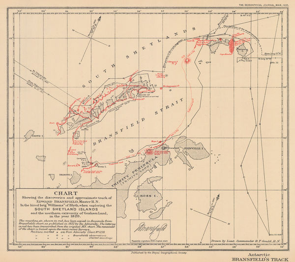
Royal Geographical Society (RGS), South Shetland Islands, 1925£ 850.00
-
J. Gordon Hayes, No. 1, Antarctica, 1928£ 795.00
-
J. Gordon Hayes, No. 4 The Ross Dependancy, 1928£ 695.00
-
Discoveries in Graham Land by Sir Hubert Wilkins, December, 1928, 1929Royal Geographical Society (RGS)Series: LondonRoyal Geographical Society (RGS), Discoveries in Graham Land by Sir Hubert Wilkins, December, 1928, 1929£ 450.00
-
Recent Work of Norwegian Expeditions in the Antarctic Regions, 1931Royal Geographical Society (RGS)Series: LondonRoyal Geographical Society (RGS), Recent Work of Norwegian Expeditions in the Antarctic Regions, 1931£ 375.00
-
Royal Geographical Society (RGS), Antarctic Regions, 1932£ 1,400.00
-
Surveys and Soundings of the R.R.S. Discovery II, 1932Royal Geographical Society (RGS)Series: LondonRoyal Geographical Society (RGS), Surveys and Soundings of the R.R.S. Discovery II, 1932£ 280.00
-
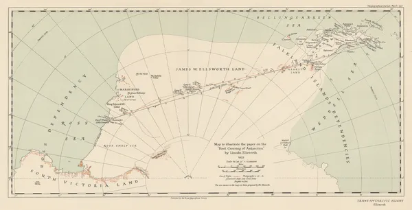
Royal Geographical Society (RGS), The "First Crossing of Antarctica", 1937£ 650.00
-
The Course of Antarctic Exploration between Longitudes 20W and 110E, 1939Royal Geographical Society (RGS)Series: LondonRoyal Geographical Society (RGS), The Course of Antarctic Exploration between Longitudes 20W and 110E, 1939£ 850.00
-
Royal Geographical Society (RGS), British Graham Land Expedition, 1940£ 1,550.00
-
British Antarctic Territory - Alexander Island and Charcot Island, 1963Royal Geographical Society (RGS)Series: LondonRoyal Geographical Society (RGS), British Antarctic Territory - Alexander Island and Charcot Island, 1963£ 295.00


Page
2
of 2