-
 Pierre Mortier, Hudson Bay, Baffin Bay and Davis Straits, 1700£ 1,500.00
 -
-
Pierre Mortier, Sea Chart of West Africa from Ghana to Angola, 1700£ 1,450.00
-
Pierre Mortier, Sea chart of Luanda, Angola, 1700£ 1,200.00
-
Pierre Mortier, Chart of West Africa from Guinea to Ghana, 1700£ 1,450.00
-
Pierre Mortier, Cape of Good Hope to Ponta das Pedras, 1700£ 2,500.00
-
Nicolas Sanson, Sri Lanka (Ceylon) and the Maldives, 1700£ 445.00
-
Nicolas de Fer, Important map of California as an island, 1700£ 2,350.00
-
Nicolas Sanson, Empire of Poland, 1700£ 445.00
-
Nicolas & Guillaume Sanson, Europe, 1700£ 495.00
-
Nicolas Sanson, France, 1700£ 350.00
-
Nicolas Sanson, Seventeen United Provinces of the Low Countries, 1700£ 295.00
-
Nicolas Sanson, British Isles, 1700£ 575.00
-
Nicolas de Fer, French copper-engraved map of Africa, 1700£ 850.00
-
Denis Martineau Du Plessis, Early map of South America, 1700£ 375.00
-
Guillaume De L'Isle, Influential map of Asia, 1700£ 685.00
-
Nicolas Sanson, L'Empire du Grand Mogol, 1700£ 640.00
-
Nicolas Sanson, Italy, Sicily, Corsica, and Sardinia, 1700£ 595.00
-
Nicolas Sanson, England during the Anglo-Saxon Heptarchy, 1700£ 475.00
-
Nicolas & Guillaume Sanson, Spanish Florida, 1700£ 1,500.00
-
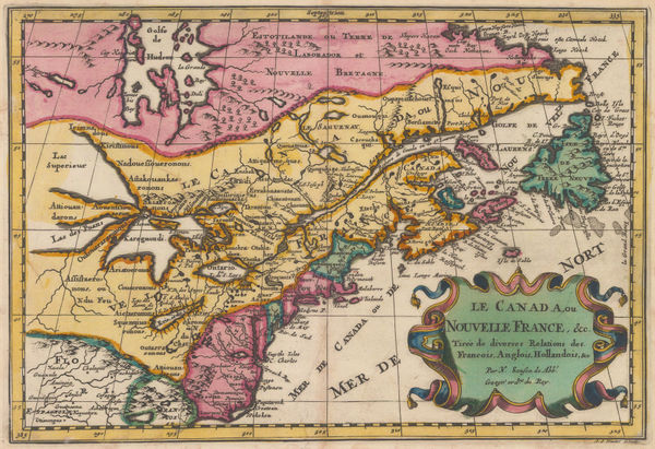
Pierre Mortier, Eastern Canada and Hudson Bay, 1700£ 4,450.00
-
Nicolas & Guillaume Sanson, Early map of eastern Canada , 1700£ 1,250.00
-
Nicolas Sanson, Peru & the Upper Amazon Basin, 1700£ 280.00
-
Nicolas Sanson, Norther Netherlands or Holland, 1700£ 295.00
-
Nicolas Sanson, Kingdom of Fez (northern Morocco), 1700£ 345.00
-
Nicolas Sanson, East coast of Africa, 1700£ 475.00
-
Nicolas Sanson, Switzerland, 1700£ 550.00
-
Nicolas Sanson, Early map of Japan, 1700£ 1,750.00
-
Nicolas de Fer, London & Westminster, 1700£ 885.00
-
Valk & Schenk, Magni Mogolis Imperium, 1700£ 1,400.00
-
Myanmar, Laos, Thailand, Cambodia, Vietnam and Malay Peninsula, 1700Nicolas & Guillaume SansonSeries: AmsterdamNicolas & Guillaume Sanson, Myanmar, Laos, Thailand, Cambodia, Vietnam and Malay Peninsula, 1700£ 595.00
-
Nicolas Sanson, Partie de Turquie en Europe, 1700£ 275.00
-
Nicolas & Guillaume Sanson, Southern Morocco and Western Sahara, 1700£ 325.00
-
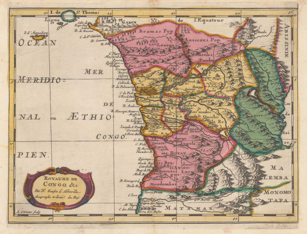
Nicolas & Guillaume Sanson, Kingdom of Congo, 1700£ 495.00
-
Nicolas & Guillaume Sanson, European Russia, 1700£ 585.00
-
Nicolas Sanson, Syria, Iraq, the Levant, and Kurdistan, 1700£ 395.00
-
John Oliver, St. Albans, 1700£ 795.00
-
Typus Totius Orbis Terraquei Geographice Delineatus, et Ad Usum Globo Materiali Superinducendus, 1700Heinrich SchererSeries: MunichHeinrich Scherer, Typus Totius Orbis Terraquei Geographice Delineatus, et Ad Usum Globo Materiali Superinducendus, 1700£ 1,650.00
-
Nicolas & Guillaume Sanson, Astronomical Diagrams, 1700£ 245.00
-
Nicolas & Guillaume Sanson, Astronomical Diagrams - the Earth's Revolution, 1700£ 245.00
-
Nicolas & Guillaume Sanson, Astronomical Diagrams - Earth's Orbit, 1700£ 245.00
-
Nicolas & Guillaume Sanson, Astronomical Diagrams - the Solar System, 1700£ 245.00
-
Nicolas Sanson, The Middle East and Mediterranean illustrating Biblical Geography, 1700£ 595.00
-
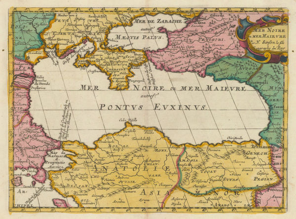
Nicolas & Guillaume Sanson, Black Sea, 1700£ 375.00
-
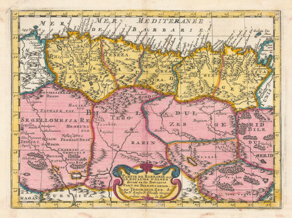
Nicolas & Guillaume Sanson, Partie de Barbarie en est le Royaume d'Alger., 1700£ 350.00
-
Robert Morden, Germany and the Holy Roman Empire, 1700 c£ 88.00
-
Robert Morden, A New Map of Hispania and Portugallia, 1700 c£ 225.00
-
Robert Morden, Malaysia, Thailand, Vietnam, Laos, Cambodia & Myanmar, 1700 c£ 395.00
-
Christoforus Cellarius, Ancient Sicily, 1700 c£ 375.00
-
Herman Moll, London and its Environs 20 Miles Around, 1700 c.£ 375.00
-
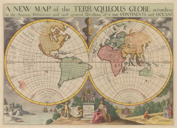
A New Map of the Terraqueous Globe according to the Ancient Discoveries, 1700 c.Edward WellsSeries: OxfordEdward Wells, A New Map of the Terraqueous Globe according to the Ancient Discoveries, 1700 c.£ 2,750.00
-
Johann Baptist Homann, Map and Panoramic View of London, 1700 c.£ 4,950.00
-
-
-
Heinrich Scherer, Baja California and Mexico, 1700 c.£ 985.00
-
Valk & Schenk, Devoniae, 1700 c.£ 885.00
-
Valk & Schenk, Guangxi, Yunnan, Guangdong and Guizhou provinces, 1700 c.£ 2,450.00
-
Alexis-Hubert Jaillot, Marseille, 1700 c.£ 155.00
-
Jacob von Sandrart, Nova Tabula Americae, 1700 c.£ 2,950.00
-
Pierre Mortier, Chart of the North Atlantic Ocean, 1700 c.£ 1,950.00
-
-
Johannes van Keulen, Chart of the Lesser Antilles, 1700 c.£ 1,550.00
-
Johannes van Keulen, Chart of the Balearic Islands and Spanish coast, 1700 c.£ 2,350.00
-
Heinrich Scherer, North America showing the reach of Catholic missionaries, 1700 c.£ 1,750.00
-
Heinrich Scherer, Catholic Map of World on a Polar Projection, 1700 c.£ 1,275.00
-
Valk & Schenk, Dutch Golden Age map of Sicily, 1700 c.£ 1,250.00
-
Valk & Schenk, Sumatra and Singapore Straits, 1700 c.£ 2,000.00
-
Valk & Schenk, Lebanon and Syria, 1700 c.£ 825.00
-
Capt. Greenvile Collins, The Islands of Scilly, 1700 c.£ 1,450.00
-
Alexis-Hubert Jaillot, Toulon, 1700 c.£ 155.00
-
Heinrich Scherer, World Map, 1700 c.£ 2,650.00
-
Edward Wells, Educational map of Asia, 1700 c.£ 445.00
-
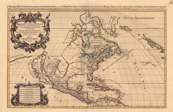
Nicolas & Guillaume Sanson, Amerique Septentrionale, 1700 c.£ 1,150.00
-
Guillaume De L'Isle, Turkey, Arabia and Persia (Iran), 1701£ 1,150.00
-
Robert Morden, Cornwall, 1701£ 295.00
-
Robert Morden, Denbigh Shire, 1701£ 135.00
-
Robert Morden, Flintshire, 1701£ 115.00
-
Robert Morden, Monmouthshire, 1701£ 75.00
-
Robert Morden, Radnor Shire, 1701£ 48.00
-
Heinrich Scherer, Regionvm Circvm Polarivm, 1701£ 950.00


Page
19
of 130