-
 William Maitland, Aldersgate Ward, 1754£ 395.00
 -
Isaac Tirion, Kaart van Londen, 1754£ 1,350.00
-
Emanuel Bowen & Thomas Kitchin, Glamorgan, 1754£ 395.00
-
Emanuel Bowen & Thomas Kitchin, Carmarthenshire, 1754£ 265.00
-
William Maitland, Queenhithe Ward and Vintry Ward, 1754£ 195.00
-
John Stow, A Map of the Tower Liberty, 1754£ 395.00
-
John Stow, Old Street, Barbican & Moorfields, 1755£ 395.00
-
William Maitland, Islington, Holborn, Clerkenwell & Farringdon, 1755£ 475.00
-
-
Jacques-Nicolas Bellin, Chart of the Azores, 1755£ 475.00
-
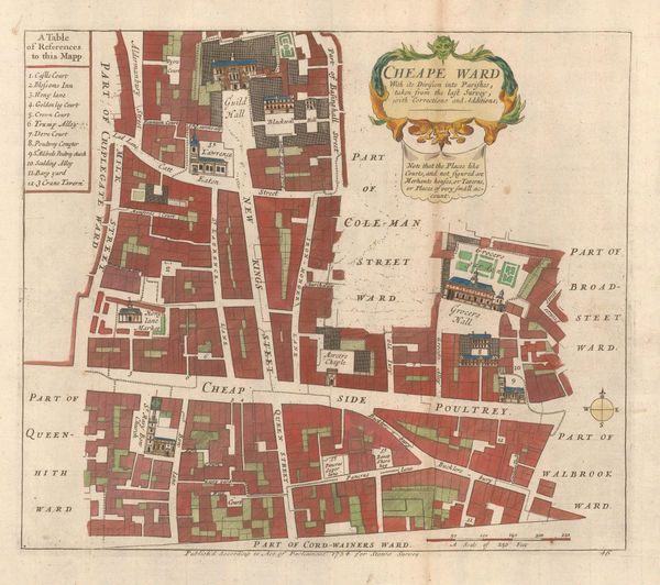
Cheap Ward with its Divisions into Parishes According to a New Survey, 1755William MaitlandSeries: LondonWilliam Maitland, Cheap Ward with its Divisions into Parishes According to a New Survey, 1755£ 445.00
-
John Stow, Cheape Ward, 1755£ 325.00
-
William Maitland, Langborne Ward and Candlewick Ward, 1755£ 775.00
-
Isaac Tirion, East coast showing British claims, 1755£ 1,125.00
-
Robert de Vaugondy, Ohio River and Northeast Colonies, 1755£ 1,650.00
-
Important German rendition of Bellin's seminal map of the Great Lakes, 1755Homann HeirsSeries: NurembergHomann Heirs, Important German rendition of Bellin's seminal map of the Great Lakes, 1755£ 3,650.00
-
Homann Heirs, Newfoundland, Quebec, Nova Scotia and New Brunswick, 1755£ 1,150.00
-
John Stow, Wapping & Shadwell, 1755£ 240.00
-
Emanuel Bowen, Devonshire, 1755£ 125.00
-
John Stow, London Bridge & Bermondsey, 1755£ 295.00
-
Robert de Vaugondy, Virginia, Maryland & Delaware, 1755£ 4,950.00
-
John Stow, A Map of the Parish of St. Mary Whitechapel, 1755£ 325.00
-
William Owen, French & Indian War Map of New England, 1755£ 950.00
-
Thomas Bowen, British and French Settlements in America, 1755£ 4,500.00
-
John Stow, Coleman Street Ward and Bashishaw Ward, 1755£ 285.00
-
-
Herman Moll, A Chart of Part of ye Sea Coast of England, Holland & Flanders, 1755 c.£ 195.00
-
Herman Moll, A Description of the Bay of Fundy, 1755 c.£ 395.00
-
John Stow, A Mapp of Lime Street Ward, 1755 c.£ 118.00
-
A New and Correct Map of Scotland & the Isles, containing all of ye Cities, Market towns, Boroughs &c, the principal Roads, with ye Computed Miles from Town to Town, 1755 c.Herman MollSeries: LondonHerman Moll, A New and Correct Map of Scotland & the Isles, containing all of ye Cities, Market towns, Boroughs &c, the principal Roads, with ye Computed Miles from Town to Town, 1755 c.£ 525.00
-
Herman Moll, United States and Canada, 1755 c.£ 1,250.00
-
Herman Moll, A Plan of Port Royal Harbour in Carolina, 1755 c.£ 395.00
-
Tobias Conrad Lotter, Africa, 1755 c.£ 225.00
-
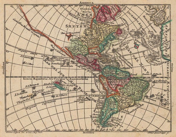
Tobias Conrad Lotter, America, 1755 c.£ 225.00
-
Herman Moll, Asia, 1755 c.£ 3,500.00
-
Herman Moll, Asia, 1755 c.£ 225.00
-
Tobias Conrad Lotter, Asia, 1755 c.£ 195.00
-
Tobias Conrad Lotter, Miniature map of Hapsburg Bohemia, 1755 c.£ 95.00
-
Tobias Conrad Lotter, Germany and the Holy Roman Empire, 1755 c.£ 95.00
-
Tobias Conrad Lotter, Miniature map of Europe, 1755 c.£ 195.00
-
Herman Moll, France, 1755 c.£ 145.00
-
Tobias Conrad Lotter, The Russian Empire in Asia, 1755 c.£ 145.00
-
Jacques-Nicolas Bellin, German edition of Bellin's map of North America, 1755 c.£ 625.00
-
Herman Moll, New England, New York, New Jersey and Pennsilvania, 1755 c.£ 1,750.00
-
Tobias Conrad Lotter, Miniature map of Italy, 1755 c.£ 145.00
-
Tobias Conrad Lotter, Netherlands, Belgium & Luxembourg, 1755 c.£ 85.00
-
Tobias Conrad Lotter, Eastern Canada, 1755 c.£ 2,200.00
-
Jacques-Nicolas Bellin, City plan of Lopburi (Louvo), 1755 c.£ 525.00
-
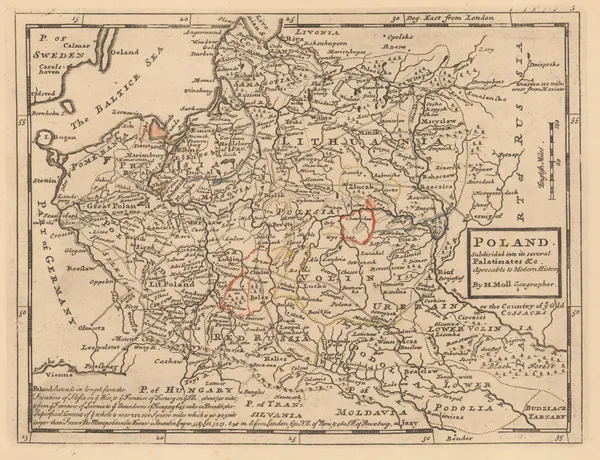
Herman Moll, Poland subdivided into its several Palatinates, 1755 c.£ 145.00
-
Tobias Conrad Lotter, Denmark, 1755 c.£ 95.00
-
Tobias Conrad Lotter, European Russia, Black Sea, Ukraine, and Baltic States, 1755 c.£ 125.00
-
Herman Moll, Sweden, Norway & Finland, 1755 c.£ 195.00
-
Tobias Conrad Lotter, Miniature map of the Balkans, Greece, the Aegean, 1755 c.£ 95.00
-
Herman Moll, North Africa, 1755 c.£ 155.00
-
Herman Moll, The Empire of China and the Island of Japan, 1755 c.£ 625.00
-
Herman Moll, St. Kitts, 1755 c.£ 395.00
-
Herman Moll, The North Part of Turky in Europe, Slavonia & c, 1755 c.£ 95.00
-
Herman Moll, Philippines, Indonesia and Malaysia, 1755 c.£ 495.00
-
The Roads of ye South Part of Great Britain, called England and Wales ..., 1755 c.Herman MollSeries: LondonHerman Moll, The Roads of ye South Part of Great Britain, called England and Wales ..., 1755 c.£ 575.00
-
Tobias Conrad Lotter, The Balkans during Russo-Turkish War of 1735-8, 1755 c.£ 95.00
-
-
Newfoundland, St. Laurence Bay, The Fishing Banks, Acadia and Part of New Scotland, 1755 c.Herman MollSeries: LondonHerman Moll, Newfoundland, St. Laurence Bay, The Fishing Banks, Acadia and Part of New Scotland, 1755 c.£ 375.00
-
London Magazine, New York State and northern New Jersey, 1756£ 525.00
-
London Magazine, A Map of the Province of Pennsylvania, 1756£ 495.00
-
London Magazine, Menorca, 1756£ 585.00
-
London Magazine, A Plan of the New Road from Paddington to Islington, 1756£ 75.00
-
William Maitland, Aldgate Ward, 1756£ 165.00
-
Georges-Louis Le Rouge, South America divided along old colonial borders, 1756£ 185.00
-
Emanuel Bowen & Thomas Kitchin, An Accurate Map of Buckinghamshire, 1756£ 795.00
-
An Accurate Map of the Counties of Leicester and Rutland, 1756Emanuel Bowen & Thomas KitchinSeries: LondonEmanuel Bowen & Thomas Kitchin, An Accurate Map of the Counties of Leicester and Rutland, 1756£ 350.00
-
An Accurate Map of the County of Worcester Divided into its Hundreds, 1756Emanuel BowenSeries: LondonEmanuel Bowen, An Accurate Map of the County of Worcester Divided into its Hundreds, 1756£ 550.00
-
William Maitland, Breadstreet Ward and Cordwainers Ward, 1756£ 245.00
-
Georges-Louis Le Rouge, Ireland divided into the four ancient provinces, 1756£ 225.00
-
Robert de Vaugondy, Africa, 1756£ 625.00
-
Georges-Louis Le Rouge, Brittany, 1756£ 95.00
-
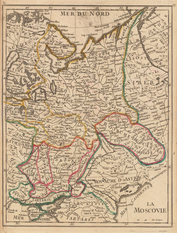
Georges-Louis Le Rouge, Muscovy or European Russia, 1756£ 95.00
-
Georges-Louis Le Rouge, Scandinavia, 1756£ 125.00
-
Robert de Vaugondy, Scandinavia, 1756£ 625.00
-
William Maitland, The Wards of Coleman Street and Bassishaw, 1756£ 265.00
-
Tower Street Ward with their Divisions into Parishes according to a New Survey, 1756William MaitlandSeries: LondonWilliam Maitland, Tower Street Ward with their Divisions into Parishes according to a New Survey, 1756£ 220.00


Page
32
of 130