-
 William Maitland, Walbrook Ward and Dowgate Ward, 1756£ 245.00
 -
A Plan of the City and Liberties of London after the Dreadful Conflagration in the Year 1666, 1756Emanuel BowenSeries: LondonEmanuel Bowen, A Plan of the City and Liberties of London after the Dreadful Conflagration in the Year 1666, 1756£ 625.00
-
A Map of Maryland with the Delaware Counties and the Southern Part of New Jersey, 1757London MagazineSeries: LondonLondon Magazine, A Map of Maryland with the Delaware Counties and the Southern Part of New Jersey, 1757£ 625.00
-
London Magazine, The Coast of Andhra Pradesh, 1757£ 125.00
-
Jacques-Nicolas Bellin, Chart of the Bay of Trincomalee (Gokanna or Gokarna), 1757£ 185.00
-
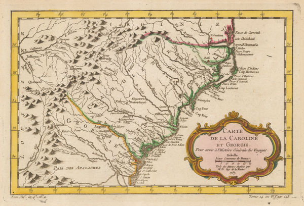
Jacques-Nicolas Bellin, Georgia and North and South Carolina, 1757£ 675.00
-
Jacques-Nicolas Bellin, New England, 1757£ 575.00
-
Carte des Côtes de Malabar et de Coromandel, 1757Covens (Jean) & Mortier (Cornelius)Series: AmsterdamCovens (Jean) & Mortier (Cornelius), Carte des Côtes de Malabar et de Coromandel, 1757£ 795.00
-
Jean de Beaurain, French sea chart of the Channel Islands, 1757£ 2,250.00
-
Jacques-Nicolas Bellin, French sea chart of the Atlantic Ocean, 1757£ 985.00
-
Jean de Beaurain, Chart of Jersey, 1757£ 2,850.00
-
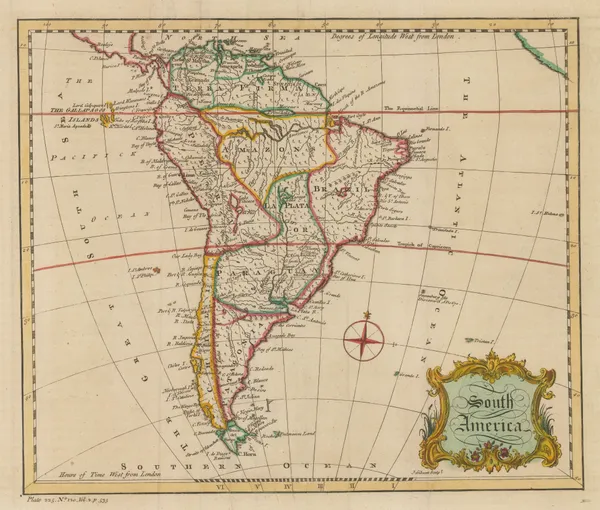
Covens (Jean) & Mortier (Cornelius), South America, 1757£ 1,200.00
-
Covens (Jean) & Mortier (Cornelius), L'Amerique Septentrionale, 1757£ 4,200.00
-
John Rocque, Middlesex, or North & West London, 1757£ 1,450.00
-
-
Jacques-Nicolas Bellin, Early French city plan of Buenos Aires, 1757£ 345.00
-
Jacques-Nicolas Bellin, St. Lawrence River from Quebec to Lake Ontario, 1757£ 325.00
-
Jacques-Nicolas Bellin, Southeastern India during the Seven Years War, 1757£ 125.00
-
Jacques-Nicolas Bellin, Boston, 1757£ 625.00
-
Covens (Jean) & Mortier (Cornelius), Persia, 1757£ 1,150.00
-
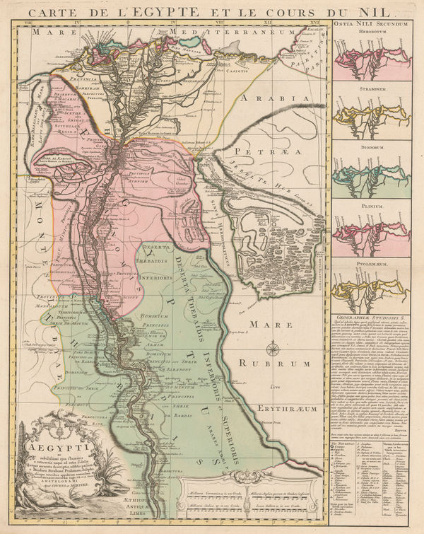
Covens (Jean) & Mortier (Cornelius), Egypt and the Nile, 1757 c.£ 1,250.00
-
London Magazine, The Cotentin Peninsula, Normandy, 1758£ 60.00
-
London Magazine, A Map of the Harbour of Louisburg and parts adjacent, 1758£ 145.00
-
London Magazine, A Plan of the Fort and Bay of Frontenac, 1758£ 145.00
-
London Magazine, An Accurate Chart of the World, 1758£ 1,350.00
-
Jacques-Nicolas Bellin, Guadeloupe divided into parishes, 1758£ 145.00
-
Jacques-Nicolas Bellin, St. Lucia, 1758£ 245.00
-
Jacques-Nicolas Bellin, Chart Jamaica, 1758£ 1,150.00
-
Jacques-Nicolas Bellin, Chart of Antigua, 1758£ 1,450.00
-
Jacques-Nicolas Bellin, North Atlantic & Scandinavia, 1758£ 395.00
-
Peter Conrad Monath, World Map, 1758£ 1,950.00
-
London Magazine, Connecticut and Rhode Island, 1758£ 685.00
-
Jacques-Nicolas Bellin, Carte de l'Isle de la Martinique, 1758£ 115.00
-
Jacques-Nicolas Bellin, Carte de L'Isle de la Barbade, 1758£ 1,750.00
-
Covens (Jean) & Mortier (Cornelius), Chart of the Windward Islands, 1758 c.£ 795.00
-
Covens (Jean) & Mortier (Cornelius), France, 1758 c.£ 575.00
-
Jacques-Nicolas Bellin, Important and early map of Australia, 1758 c.£ 2,550.00
-
Thomas Salmon, Cape Town and environs, 1759£ 395.00
-
Gentleman's Magazine, Île d'Orléans and Quebec City, 1759£ 85.00
-
Jacques-Nicolas Bellin, St. Kitts, 1759£ 225.00
-
Jacques-Nicolas Bellin, Carte des Entrees de la Tamise, 1759£ 625.00
-
Jacques-Nicolas Bellin, Northern coast of Hudson Bay, 1759£ 295.00
-
Thomas Salmon, Europe, 1759£ 375.00
-
Thomas Salmon, South America, 1759£ 295.00
-
Thomas Salmon, A Chart of the Western Coast of Africa, 1759£ 175.00
-
Homann Heirs, Barbados, 1759£ 395.00
-
-
Gentleman's Magazine, Martinique and Guadeloupe, 1759 c.£ 80.00
-
London Magazine, Morocco divided into the four historic kingdoms, 1760£ 85.00
-
Emanuel Bowen & Thomas Kitchin, A New and Accurate Map of Warwickshire, 1760£ 850.00
-
London Magazine, A New Map of the Cherokee Nation, 1760£ 2,250.00
-
Emanuel Bowen, A New Map of the Counties of Cumberland and Westmoreland, 1760£ 695.00
-
London Magazine, A Plan of the City of Berlin, 1760£ 285.00
-
A Plan of the Roads and Streets from Islington to Dog House Bar delineated to shew a New Road, 1760London MagazineSeries: LondonLondon Magazine, A Plan of the Roads and Streets from Islington to Dog House Bar delineated to shew a New Road, 1760£ 85.00
-
Emanuel Bowen, An Accurate Map of Cambridgeshire Divided into its Hundreds, 1760£ 625.00
-
An Accurate Map of Nottinghamshire Describing its Wapontakes and Divisions, 1760Emanuel Bowen & Thomas KitchinSeries: LondonEmanuel Bowen & Thomas Kitchin, An Accurate Map of Nottinghamshire Describing its Wapontakes and Divisions, 1760£ 395.00
-
Jean Joseph Georges d'Expilly, Miniature map of Asia, 1760£ 145.00
-
Jacques-Nicolas Bellin, Sumatra and the Malacca Straits, 1760£ 450.00
-
Richard William Seale, Arabia, 1760 (c.)£ 2,250.00
-
Emanuel Bowen, A New Improved Map of Cornwall, 1760 c£ 2,200.00
-
Emanuel Bowen, An Accurate Map of the East Riding of Yorkshire, 1760 c£ 1,150.00
-
Emanuel Bowen, An Improved Map of Wiltshire Divided into its Hundreds, 1760 c£ 1,150.00
-
Richard William Seale, Map of the County of Middlesex, 1760 c£ 775.00
-
T. & E. Bowen, A Corrected Map of the County of Stafford Divided into Hundreds, 1760 c.£ 475.00
-
A New - Enereasing Compass Map of Part of the East-Coast of England; extending from Eckles to Flamborough-Head; containing the River of Hull; with their Shallow nesses and depths by Claas de Vries Geometra, 1760 c.Gerard van KeulenSeries: AmsterdamGerard van Keulen, A New - Enereasing Compass Map of Part of the East-Coast of England; extending from Eckles to Flamborough-Head; containing the River of Hull; with their Shallow nesses and depths by Claas de Vries Geometra, 1760 c.£ 485.00
-
Emanuel Bowen, Piedmont, Savoy and Montferrat, 1760 c.£ 495.00
-
Thomas Kitchin, The Gulf of Mexico and the Caribbean, 1760 c.£ 375.00
-
Emanuel Bowen & Thomas Kitchin, A New Improved Map of Hampshire, 1760 c.£ 1,750.00
-
A New Improved Map of Hartfordshire from the Best Surveys & Intelligence Divided into its Hundreds, 1760 c.Thomas KitchinSeries: LondonThomas Kitchin, A New Improved Map of Hartfordshire from the Best Surveys & Intelligence Divided into its Hundreds, 1760 c.£ 595.00
-
Emanuel Bowen & Thomas Kitchin, A New Improved Map of Oxfordshire, 1760 c.£ 1,350.00
-
Thomas Kitchin, A New Map of Northamptonshire, 1760 c.£ 98.00
-
Thomas Kitchin, A New Map of Westmoreland, 1760 c.£ 55.00
-
Emanuel Bowen, An Accurate Map of Devon Shire, 1760 c.£ 1,350.00
-
An Accurate Map of Dorset Shire Divided into its Hundreds, 1760 c.Emanuel Bowen & Thomas KitchinSeries: LondonEmanuel Bowen & Thomas Kitchin, An Accurate Map of Dorset Shire Divided into its Hundreds, 1760 c.£ 1,250.00
-
Emanuel Bowen, An Accurate Map of Lincolnshire Divided into its Wapontakes, 1760 c.£ 650.00
-
An Accurate Map of Northamptonshire Divided into its Hundreds, 1760 c.Emanuel Bowen & Thomas KitchinSeries: LondonEmanuel Bowen & Thomas Kitchin, An Accurate Map of Northamptonshire Divided into its Hundreds, 1760 c.£ 550.00
-
Thomas Kitchin, An Accurate Map of Pembroke Shire, 1760 c.£ 395.00
-
Emanuel Bowen & Thomas Kitchin, An Accurate Map of Radnorshire, 1760 c.£ 295.00
-
Emanuel Bowen, An Accurate Map of the Counties of Gloucester and Monmouth, 1760 c.£ 1,150.00
-
An Accurate Map of the County of Bedford Divided into its Hundreds, 1760 c.Emanuel BowenSeries: LondonEmanuel Bowen, An Accurate Map of the County of Bedford Divided into its Hundreds, 1760 c.£ 650.00


Page
33
of 130