-
 Emanuel Bowen, An Accurate Map of the County of Derby, 1760 c.£ 750.00
 -
Emanuel Bowen, An Accurate Map of the County of Essex, 1760 c.£ 1,250.00
-
Emanuel Bowen, An Accurate Map of the County of Huntingdon, 1760 c.£ 425.00
-
Emanuel Bowen, An Accurate Map of the County of Kent, 1760 c.£ 1,550.00
-
T. & E. Bowen, An Accurate Map of the County of Norfolk, 1760 c.£ 950.00
-
An Accurate Map of the County of Suffolk Divided into its Hundreds, 1760 c.Emanuel BowenSeries: LondonEmanuel Bowen, An Accurate Map of the County of Suffolk Divided into its Hundreds, 1760 c.£ 1,150.00
-
Emanuel Bowen & Thomas Kitchin, An Accurate Map of the County of York, 1760 c.£ 965.00
-
Emanuel Bowen, An Accurate Map of the County Palatine of Chester, 1760 c.£ 950.00
-
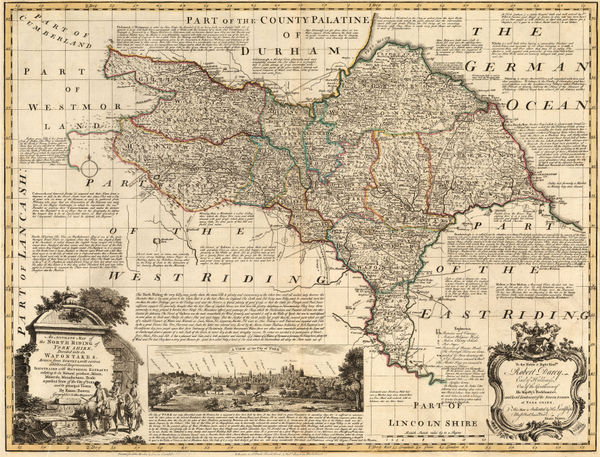
An Accurate Map of the North Riding of York Shire, 1760 c.Emanuel Bowen & Thomas KitchinSeries: LondonEmanuel Bowen & Thomas Kitchin, An Accurate Map of the North Riding of York Shire, 1760 c.£ 1,150.00
-
An Accurate Map of the West Riding of Yorkshire Divided into its Wapontakes, 1760 c.Emanuel BowenSeries: LondonEmanuel Bowen, An Accurate Map of the West Riding of Yorkshire Divided into its Wapontakes, 1760 c.£ 945.00
-
T. & E. Bowen, An Accurate Map of Worcestershire Divided into Hundreds, 1760 c.£ 350.00
-
An Improved Map of the County of Somerset Divided into its Hundreds, 1760 c.Emanuel BowenSeries: LondonEmanuel Bowen, An Improved Map of the County of Somerset Divided into its Hundreds, 1760 c.£ 1,375.00
-
Thomas Kitchin, Cardigan Shire, 1760 c.£ 375.00
-
Jacques-Nicolas Bellin, Japan, Korea, Taiwan and coast of China, 1760 c.£ 625.00
-
Jacob van der Schley, Senegal, Mauritania, and Mali, 1760 c.£ 295.00
-
Étienne André Philippe de Prétot, Carte Nouvelle d'Amerique, 1760 c.£ 795.00
-
Tobias Conrad Lotter, Sri Lanka (Ceylon) divided into regions, 1760 c.£ 1,650.00
-
Gabriel Bodenehr, Central Ukraine, Dnieper River, 1760 c.£ 325.00
-
Tobias Conrad Lotter, Greece and the Aegean Sea, 1760 c.£ 645.00
-
Matthaus Seutter, South East Asia and India, 1760 c.£ 2,650.00
-
Jacques-Nicolas Bellin, Coastal chart from Cape Fear to St. Augustine, 1760 c.£ 345.00
-
Jacques-Nicolas Bellin, Mouth of the Pearl River, 1760 c.£ 275.00
-
John Speed, Kent, 1760 c.£ 1,650.00
-
North America showing the territory fought over in the French and Indian War, 1760 c.Gabriel Nikolaus RaspeSeries: NurembergGabriel Nikolaus Raspe, North America showing the territory fought over in the French and Indian War, 1760 c.£ 625.00
-
Matthaus Seutter, Baltic States, 1760 c.£ 925.00
-
Tobias Conrad Lotter, Southern USA, Mexico, Central America & the Caribbean, 1760 c.£ 3,450.00
-
Mount & Page, New Foundland to Hudson's Bay, 1760 c.£ 925.00
-
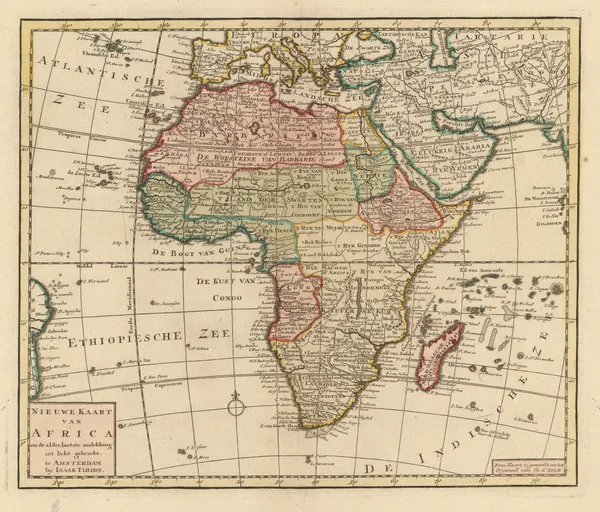
Isaac Tirion, New Map of Africa, 1760 c.£ 545.00
-
Johannes [II] van Keulen, Nieuwe Generaale Caart von de Orcades, 1760 c.£ 685.00
-
Johannes [II] van Keulen, Nieuwe Paskaert Van d'Ooft Kust van Engelandt, 1760 c.£ 825.00
-
Gerard van Keulen, Scarborough & Hartlepool, 1760 c.£ 285.00
-
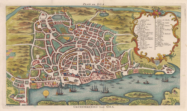
Jacob van der Schley, Bird's eye view of Goa, 1760 c.£ 295.00
-
Gabriel Nikolaus Raspe, Scarce map of Chennai (Madras), 1760 c.£ 445.00
-
Jacques-Nicolas Bellin, Cape Town, 1760 c.£ 325.00
-
Johann Michael Probst, Planisphaerium Coeleste, 1760 c.£ 3,950.00
-
Tobias Conrad Lotter, Norway, 1760 c.£ 775.00
-
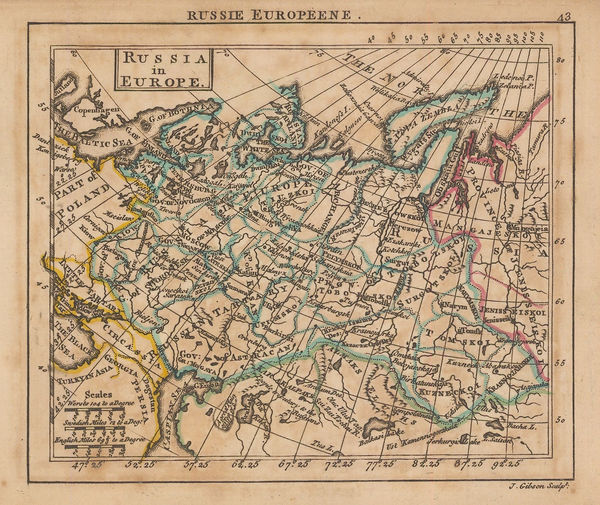
Thomas Bowen, European Russia, 1760 c.£ 82.00
-
Johannes [II] van Keulen, Schotlandt, 1760 c.£ 675.00
-
Gerard van Keulen, [River Thames][Suffolk Coastline], 1760 c.£ 765.00
-
Gerard van Keulen, [Thanet and the mouth of the River Blakeney], 1760 c.£ 265.00
-
Tobias Conrad Lotter, Sweden & Finland, 1760 c.£ 825.00
-
Emanuel Bowen, An Accurate Map of the County of Lancaster, 1760 c.£ 850.00
-
Emanuel Bowen, An Improved Map of the County of Stafford, 1760 c.£ 875.00
-
Isaac Tirion, Nouvelle Carte de L'Empire de la Chine, 1760 c.£ 925.00
-
London Magazine, A Map of Bell'Isle, 1761£ 95.00
-
London Magazine, A New Map of Virginia, 1761£ 595.00
-
John Gibson, A Plan of the City of Philadelphia with the Country Adjacent., 1761£ 245.00
-
Andrew Dury, Africa, 1761£ 175.00
-
Andrew Dury, Europe, 1761£ 175.00
-
Andrew Dury, Miniature map of Italy, 1761£ 195.00
-
Andrew Dury, Map of Senegal, with Part of the Coast of Africa, 1761£ 118.00
-
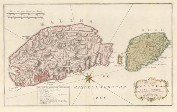
Isaac Tirion, Malta and Gozo, 1761£ 1,250.00
-
Andrew Dury, Miniature map of North America, 1761£ 295.00
-
Andrew Dury, Russia in Asia, 1761£ 88.00
-
Andrew Dury, Russia in Europe, 1761£ 95.00
-
Andrew Dury, Miniature map of Spain and Portugal, 1761£ 195.00
-
Andrew Dury, Miniature map of the Caribbean, 1761£ 185.00
-
London Magazine, Plan of New Orleans the Capital of Louisiana, 1761£ 950.00
-
London Magazine, The Isles of Montreal, 1761£ 1,350.00
-
Hemisphere Oriental ou de l'Ancien Monde and Hemisphere Occidental ou du Noveau Monde, 1761 c.J.B.B. D'AnvilleSeries: ParisJ.B.B. D'Anville, Hemisphere Oriental ou de l'Ancien Monde and Hemisphere Occidental ou du Noveau Monde, 1761 c.£ 2,350.00
-
London Magazine, India and Southeast Asia, 1762£ 375.00
-
-
A Plan of the Siege of the Havana, drawn by an Officer on the spot, 1762., 1762Political MagazineSeries: LondonPolitical Magazine, A Plan of the Siege of the Havana, drawn by an Officer on the spot, 1762., 1762£ 325.00
-
Robert de Vaugondy, North and West Africa, 1762£ 165.00
-
Jacques-Nicolas Bellin, Chart of Havana, Cuba, 1762£ 1,850.00
-
Jacques-Nicolas Bellin, Chart of Cuba and the Southern Bahamas, 1762£ 3,450.00
-
Robert de Vaugondy, Northern France, 1762£ 70.00
-
Jean Denis Janvier, South America showing European possessions, 1762£ 295.00
-
Jean Denis Janvier, Scandinavia, 1762£ 345.00
-
Emanuel Bowen, Mission of the Moxos or Moxes, 1762£ 165.00
-
Thomas Jefferys, San Juan, Puerto Rico, 1762£ 595.00
-
London Magazine, South America, 1762£ 185.00
-
London Magazine, A Chart of the Channel through which the Manila Galeon Passes, 1763£ 795.00
-
London Magazine, Jamaica divided into parishes, 1763£ 295.00
-
T. & E. Bowen, An Accurate Map of Brecknock Shire, 1763£ 225.00
-
T. & E. Bowen, An Accurate map of Hereford Shire, 1763£ 545.00
-
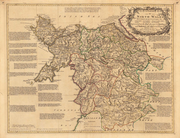
T. & E. Bowen, An Accurate Map of North Wales, 1763£ 495.00
-
T. & E. Bowen, An Accurate Map of the County Palatine of Durham, 1763£ 650.00
-
Andrew Dury, Asia, 1763£ 145.00
-
Jacques-Nicolas Bellin, Hudson Bay, 1763£ 145.00


![Johannes [II] van Keulen, Nieuwe Generaale Caart von de Orcades, 1760 c.](https://static-assets.artlogic.net/w_600,c_limit,f_auto,fl_lossy,q_auto/artlogicstorage/themaphouse/images/view/bfbbfe45b2f627581400a21685aee561j/themaphouse-johannes-ii-van-keulen-nieuwe-generaale-caart-von-de-orcades-1760-c..jpg)
![Johannes [II] van Keulen, Nieuwe Paskaert Van d'Ooft Kust van Engelandt, 1760 c.](https://static-assets.artlogic.net/w_600,c_limit,f_auto,fl_lossy,q_auto/artlogicstorage/themaphouse/images/view/b85698e11ad3b355a2ff9937c6dc3befj/themaphouse-johannes-ii-van-keulen-nieuwe-paskaert-van-d-ooft-kust-van-engelandt-1760-c..jpg)


![Johannes [II] van Keulen, Schotlandt, 1760 c.](https://static-assets.artlogic.net/w_600,c_limit,f_auto,fl_lossy,q_auto/artlogicstorage/themaphouse/images/view/14be75c40dc33491d8eed533e0a20082j/themaphouse-johannes-ii-van-keulen-schotlandt-1760-c..jpg)
![Gerard van Keulen, [River Thames][Suffolk Coastline], 1760 c.](https://static-assets.artlogic.net/w_600,c_limit,f_auto,fl_lossy,q_auto/artlogicstorage/themaphouse/images/view/a7825455b2b140129b1f50ed7b79ffc6j/themaphouse-gerard-van-keulen-river-thames-suffolk-coastline-1760-c..jpg)
![Gerard van Keulen, [Thanet and the mouth of the River Blakeney], 1760 c.](https://static-assets.artlogic.net/w_600,c_limit,f_auto,fl_lossy,q_auto/artlogicstorage/themaphouse/images/view/6145c3fc2fdd4f8e5a32ae74169abbfdj/themaphouse-gerard-van-keulen-thanet-and-the-mouth-of-the-river-blakeney-1760-c..jpg)


Page
34
of 130