-
 Willem Albert Bachiene, North and South America, 1770 c.£ 650.00
 -
Guillaume De L'Isle, French-Italian border - Piedmont and Monferrat, 1770 c.£ 700.00
-
Gentleman's Magazine, Switzerland, 1770 c.£ 85.00
-
Thomas Kitchin, Rutlandshire, 1770 c.£ 65.00
-
-
Carington Bowles, Jamaica & Port Royal, 1771£ 795.00
-
John Andrews, A Plan of the City of Hamburg, 1771£ 325.00
-
John Andrews, A Plan of the City of Turin, 1771£ 240.00
-
Carington Bowles, Portugal, 1771£ 345.00
-
Rigobert Bonne, Korean Peninsula and Northern China, 1771£ 265.00
-
Jean Lattré, Languedoc coast, 1771£ 195.00
-
Rigobert Bonne, Isère, Drôme and Hautes-Alpes, 1771£ 195.00
-
Jean Lattré, Champagne and Brie, 1771£ 95.00
-
Rigobert Bonne, Southwestern France, 1771£ 145.00
-
Rigobert Bonne, Wall map of India and Southeast Asia, 1771£ 1,250.00
-
London Magazine, Queen Hith and Vintry Wards, 1771£ 115.00
-
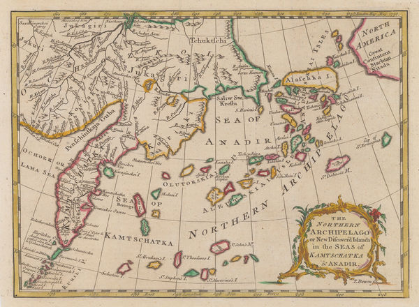
London Magazine, Kamchatka, Alaska & the Aleutian Islands, 1771£ 195.00
-
Carington Bowles, Russian Empire, 1771£ 950.00
-
Rigobert Bonne, West Africa & the Gulf of Guinea, 1771£ 195.00
-
Rigobert Bonne, Carte De L'Arabie, 1771£ 695.00
-
John Stockdale, A Plan of the City of Vienna, 1771£ 225.00
-
Rigobert Bonne, Coast of North Africa and southern Mediterranean, 1771 c.£ 225.00
-
Rigobert Bonne, The Eastern Ottoman Empire, 1771 c.£ 345.00
-
Rigobert Bonne, India and Southeast Asia, 1771 c.£ 445.00
-
Gentleman's Magazine, Coastal chart from the Mississippi to Pensacola Bay, 1772£ 495.00
-
London Magazine, A New Map of Cathness Shire, 1772£ 125.00
-
London Magazine, A New Map of Selkirkshire, 1772£ 125.00
-
Robert de Vaugondy, West coast of North America, 1772£ 695.00
-
Robert de Vaugondy, Siberia, or Asiatic Russia, 1772£ 325.00
-
Robert de Vaugondy, Carte des Parties Nord et Ouest de l'Amerique, 1772£ 695.00
-
Jacques-Nicolas Bellin, Chart of the Sea of Marmara, 1772£ 985.00
-
Étienne André Philippe de Prétot, Netherlands, Belgium & Luxembourg, 1772£ 275.00
-
Willem Albert Bachiene, France, 1772£ 365.00
-
London Magazine, Walbrook Ward and Dowgate Ward, 1772£ 125.00
-
Carsten Niebuhr, The Red Sea, 1772£ 2,250.00
-
Robert de Vaugondy, Cartographic history of California, 1772£ 1,150.00
-
Louis-Charles Desnos, Provence, 1772£ 395.00
-
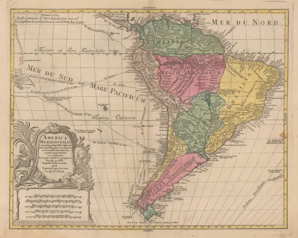
Tobias & Gustav Lotter, South America with routes of explorers, 1772 c.£ 985.00
-
Johann Jakob Baegert, California, 1773£ 1,150.00
-
Étienne André Philippe de Prétot, Paris & Île-de-France, 1773£ 145.00
-
Étienne André Philippe de Prétot, Old and new Castille, 1773£ 195.00
-
Étienne André Philippe de Prétot, Murcia, Granada and Andalusia, 1773£ 195.00
-
Capt. James Cook, Endeavour Strait to Cape Tribulation, Queensland, 1773£ 750.00
-
John Noorthouck, Broad Street & Cornhill Wards, 1773£ 185.00
-
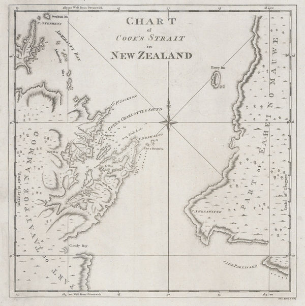
Capt. James Cook, Chart of Cook's Strait in New Zealand, 1773£ 775.00
-
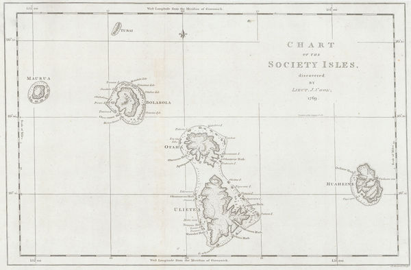
Capt. James Cook, Society Islands, 1773£ 475.00
-
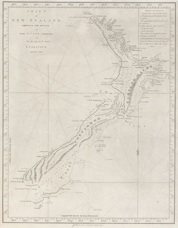
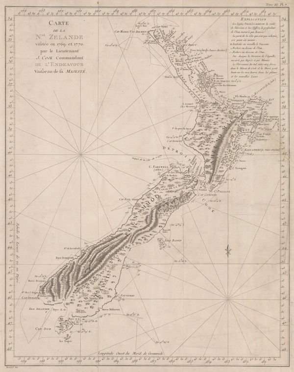
Capt. James Cook, New Zealand, 1773£ 4,950.00
-
Tomas Lopez y Vargas, Mallorca, 1773£ 3,250.00
-
Capt. James Cook, Tahiti & French Polynesia, 1773£ 245.00
-
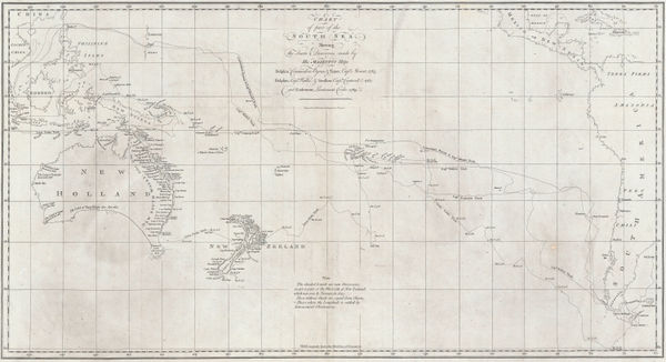
Capt. James Cook, Cook's Discoveries in Australia, New Zealand & the Pacific, 1773£ 1,750.00
-
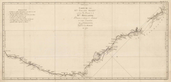
Capt. James Cook, James Cook's Map of New South Wales & Queensland, 1774£ 1,250.00
-
Capt. James Cook, New Zealand, 1774£ 3,750.00
-
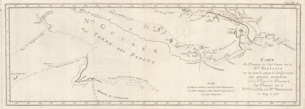
Capt. James Cook, Cook's and Dampier's routes, Papua New Guinea, 1774£ 345.00
-
Jacques-Nicolas Bellin, Chart of the West Indies and Gulf of Mexico, 1774£ 1,950.00
-
John Seller, Cheshire, 1774£ 98.00
-
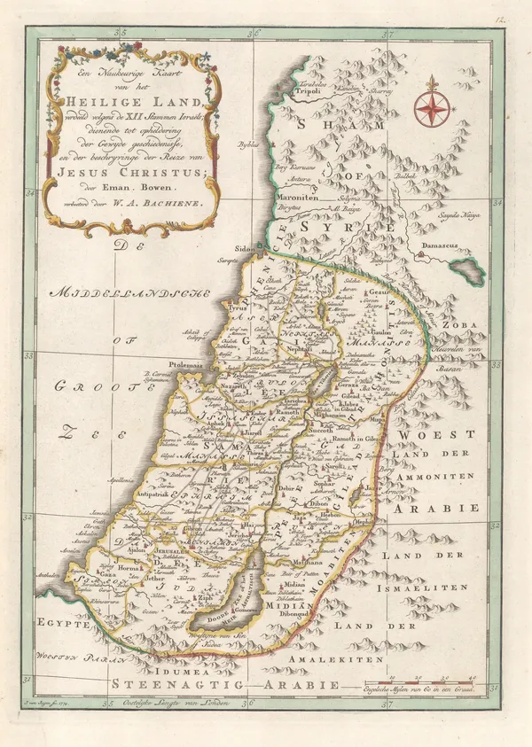
Willem Albert Bachiene, Holy Land, 1774£ 445.00
-
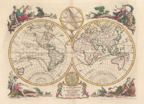
Antonio Zatta, Il Mappamondo, 1774£ 1,650.00
-
Antonio Zatta, Il Mappamondo, 1774£ 1,850.00
-
Willem Albert Bachiene, Southeast Asia, 1774£ 1,250.00
-
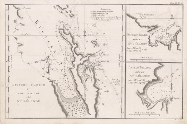
River Thames and Mercury Bay | Bay of Islands | Tolaga Bay in New Zealand, 1774Capt. James CookSeries: LondonCapt. James Cook, River Thames and Mercury Bay | Bay of Islands | Tolaga Bay in New Zealand, 1774£ 625.00
-
Willem Albert Bachiene, Ryk des Grooten Mogols en dier Indien, 1774£ 985.00
-
Carsten Niebuhr, Oman, 1774£ 1,250.00
-
Tobias & Gustav Lotter, Yemen, 1774 c.£ 1,250.00
-
Anonymous, Carte du Detroit de Magellan, 1774 c.£ 845.00
-
A General Map of Indostan or the Great Mogol's Empire with the Adjacent Countries, 1775Robert OrmeSeries: LondonRobert Orme, A General Map of Indostan or the Great Mogol's Empire with the Adjacent Countries, 1775£ 385.00
-
Robert Orme, Sri Lanka (Ceylon) and Coromandel coast , 1775£ 495.00
-
-
Prince Edward Island divided into counties, parishes, and individual land grants, 1775Andrew DurySeries: LondonAndrew Dury, Prince Edward Island divided into counties, parishes, and individual land grants, 1775£ 845.00
-
Thomas Jefferys, Chart of the St Lawrence River, 1775£ 1,250.00
-
Depot de la Marine, French sea chart of the North Atlantic, 1775£ 825.00
-
-
Thomas Jefferys, Dominica, 1775£ 1,250.00
-
Thomas Jefferys, Guadeloupe, 1775£ 985.00
-
Thomas Jefferys, Martinique, 1775£ 1,150.00
-
Thomas Jefferys, St Vincent from an Actual Survey, 1775£ 1,850.00
-
Thomas Jefferys, St. Lucia, 1775£ 2,450.00
-
Thomas Jefferys, Veracruz, Oazaco, Chiapas & Tabasco, Mexico, 1775£ 550.00
-
Thomas Jefferys, The Coast of West Florida and Louisiana, 1775£ 1,250.00
-
Thomas Jefferys, Cuba and the Bahama Banks, 1775£ 2,500.00
-
Thomas Jefferys, Jamaica and the Mosquito Coast, 1775£ 350.00


Page
41
of 130