-
 Charles Smith, Brazil, 1834£ 145.00
 -
John Arrowsmith, Colombia, 1834£ 595.00
-
Thomas Bradford, Denmark, Sweden, Norway, and Lapland, 1834£ 40.00
-
Society for the Diffusion of Useful Knowledge (SDUK), Eastern United States, 1834£ 225.00
-
Justus Perthes, Southeastern Australia, 1834£ 375.00
-
Christopher & John Greenwood, Map of the County of Buckingham, 1834£ 595.00
-
Christopher & John Greenwood, Map of the County of Cambridge, 1834£ 450.00
-
Christopher & John Greenwood, Map of the County of Hereford, 1834£ 325.00
-
Christopher & John Greenwood, Map of the County of Hertford, 1834£ 495.00
-
Christopher & John Greenwood, Map of the County of Norfolk, 1834£ 520.00
-
Christopher & John Greenwood, Map of the East Riding of the County of York, 1834£ 385.00
-
Christopher & John Greenwood, Map of the North Riding of the County of York, 1834£ 575.00
-
Map of the North West Circuit of The Principality of Wales, 1834Christopher & John GreenwoodSeries: LondonChristopher & John Greenwood, Map of the North West Circuit of The Principality of Wales, 1834£ 385.00
-
Christopher & John Greenwood, Map of the West Riding of the County of York, 1834£ 675.00
-
Charles Smith, New Brunswick, Nova Scotia, &c., 1834£ 165.00
-
Charles Smith, Australia and New Zealand, 1834£ 445.00
-
Charles Smith, Northern and Central Italy, 1834£ 88.00
-
Algerian coast from Bonah to Magrowah, 1834Society for the Diffusion of Useful Knowledge (SDUK)Series: LondonSociety for the Diffusion of Useful Knowledge (SDUK), Algerian coast from Bonah to Magrowah, 1834£ 86.00
-
Adrien Brue, South America on two sheets, 1834£ 2,450.00
-
John Arrowsmith, Peru & Bolivia, 1834£ 145.00
-
William Darton, Poland and Prussia, 1834£ 88.00
-
Charles Smith, Russian Empire, 1834£ 145.00
-
Royal Geographical Society (RGS), Sketch of Part of the Himma-Leh Mountains, 1834£ 120.00
-
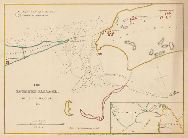
Royal Geographical Society (RGS), Chart of the Palk Strait (Paumbum Passage), 1834£ 125.00
-
Charles Smith, Turkey in Asia, 1834£ 175.00
-
Charles Smith, United States, 1834£ 295.00
-
Charles Smith, Upper and Lower Canada, 1834£ 225.00
-
Charles Smith, South Africa, 1834£ 375.00
-
Edward Mogg, Mogg's Map of Steam Navigation, 1834£ 1,250.00
-
-
John Lothian, Dumfries, 1835£ 145.00
-
J. & C. Walker, Gloucestershire, 1835£ 125.00
-
J. & C. Walker, Kent, 1835£ 72.00
-
John Lothian, Kirkudbrightshire, 1835£ 145.00
-
Charles Smith, Map of India Exhibiting its Present Political Divisions, 1835£ 695.00
-
-
Edward Mogg, New Map of England and Wales with Part of Scotland, 1835£ 1,350.00
-
British Admiralty, Plan of the Harbour of Tripoli, 1835£ 300.00
-
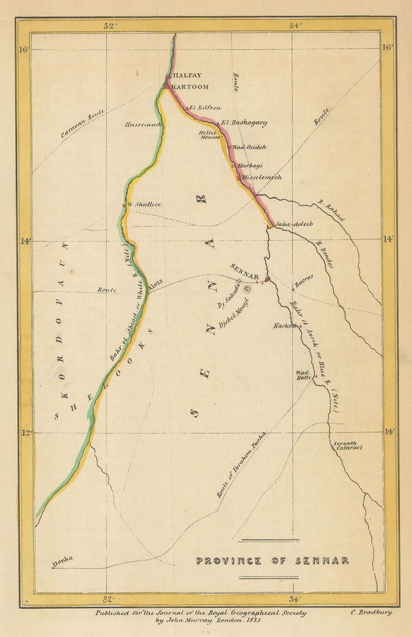
Royal Geographical Society (RGS), Sennar State, Sudan, 1835£ 76.00
-
John Lothian, Selkirk, 1835£ 145.00
-
Sketch to Illustrate the Paper by E. Stirling Esq, 1835Royal Geographical Society (RGS)Series: LondonRoyal Geographical Society (RGS), Sketch to Illustrate the Paper by E. Stirling Esq, 1835£ 58.00
-
Thomas Bradford, South America, 1835£ 45.00
-
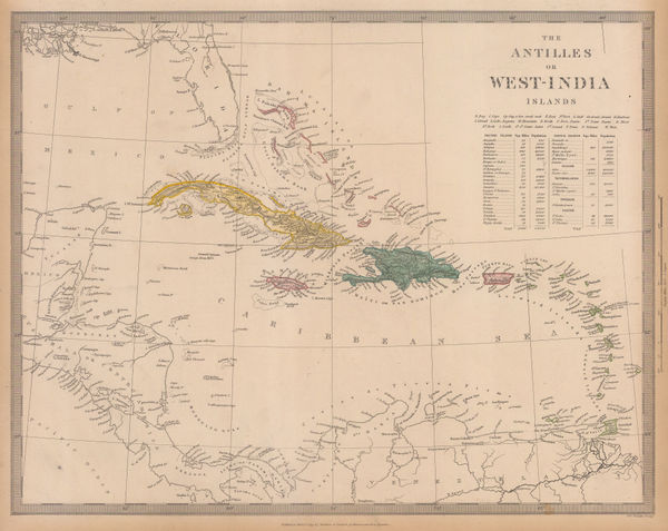
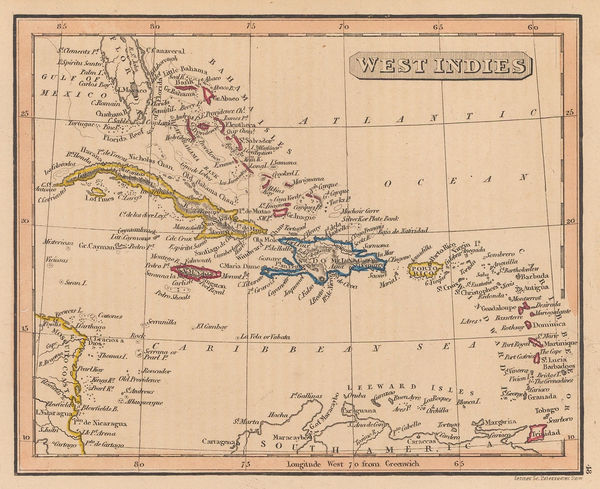
Society for the Diffusion of Useful Knowledge (SDUK), The West Indies, 1835£ 160.00
-
Thomas Bradford, Upper & Lower Canada, 1835£ 55.00
-
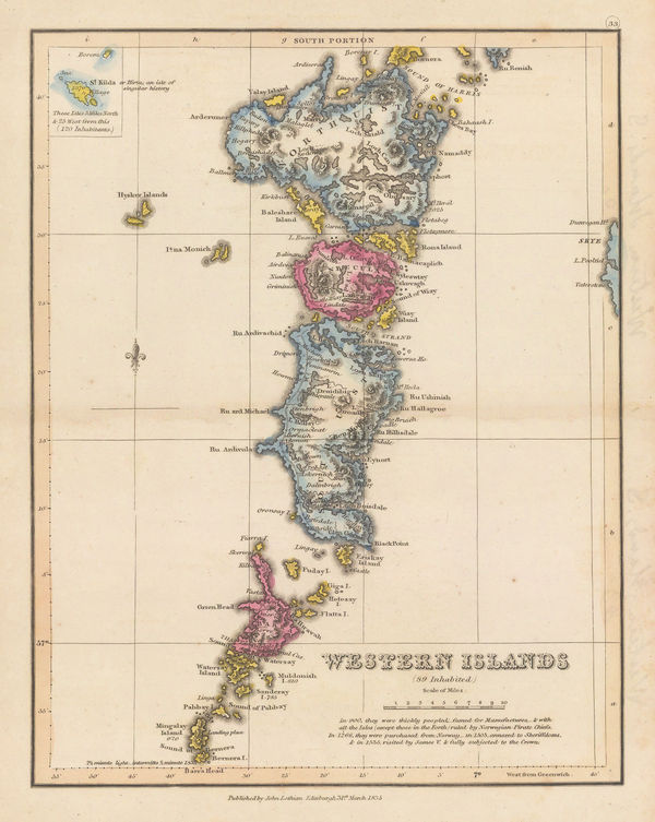
John Lothian, Western Isles (South Portion), 1835£ 145.00
-
J. & C. Walker, Somerset, 1835£ 150.00
-
Samuel Augustus Mitchell, United States, 1835£ 1,850.00
-
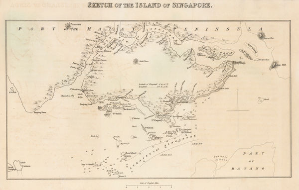
Sophia Raffles, Sketch Map of the Island of Singapore, 1835£ 3,250.00
-
Henry Teesdale, Derbyshire, 1835 c.£ 85.00
-
Henry Teesdale, Durham, 1835 c.£ 115.00
-
Daniel & William Lizars, Egypt, 1835 c.£ 245.00
-
Henry Teesdale, Hertfordshire, 1835 c.£ 125.00
-
James Pigot, Staffordshire, 1835 c.£ 90.00
-
Thomas Kelly, Switzerland, 1835 c.£ 85.00
-
British Admiralty, The Harbour and Bays of Trincomalee, 1835 c.£ 490.00
-
Henry Teesdale, Warwickshire, 1835 c.£ 95.00
-
George Washington Boynton, Turkey, Arabia & Persia, 1835 c.£ 145.00
-
Rest Fenner, Asia, 1836£ 75.00
-
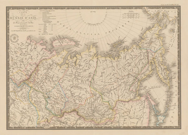
Adrien Brue, Asiatic Russia, 1836£ 145.00
-
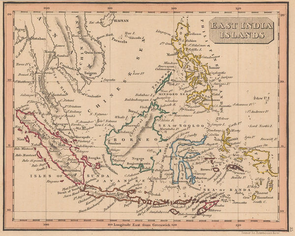
Adrien Brue, Indian and Southeast Asia showing European colonial possessions, 1836£ 245.00
-
Adrien Brue, Italy, Sicily, Sardinia and Corsica, 1836£ 165.00
-
Rest Fenner, Colony of New South Wales, 1836£ 125.00
-
J. & C. Walker, Cumberland, 1836£ 68.00
-
J. & C. Walker, Durham, 1836£ 82.00
-
Rest Fenner, Miniature map of Southeast Asia, 1836Reserved
-
J. & C. Walker, East Riding of Yorkshire, 1836£ 72.00
-
Map of the Discoveries and Route of the Arctic Land Expedition, 1836Royal Geographical Society (RGS)Series: LondonRoyal Geographical Society (RGS), Map of the Discoveries and Route of the Arctic Land Expedition, 1836£ 425.00
-
-
Adrien Brue, United States showing westward expansion, 1836£ 895.00
-
Royal Geographical Society (RGS), Coast of Morocco and Western Sahara, 1836£ 65.00
-
Thomas Kelly, Peru and Bolivia, 1836£ 70.00
-
Plan of the Rivers Ucayali & Amazon from the Mission of Sarayacu to the Rio Negro, 1836Royal Geographical Society (RGS)Series: LondonRoyal Geographical Society (RGS), Plan of the Rivers Ucayali & Amazon from the Mission of Sarayacu to the Rio Negro, 1836£ 375.00
-
Rest Fenner, Portugal, 1836£ 52.00
-
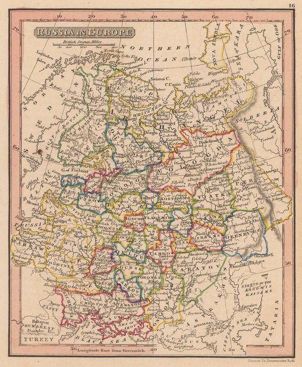
Rest Fenner, Russia in Europe, 1836£ 65.00
-
Rest Fenner, West Indies, 1836£ 78.00
-
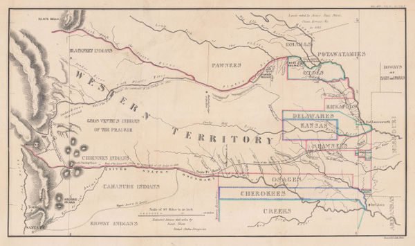
Enoch Steen, Dodge's Expedition through Kansas & Colorado, 1836£ 950.00
-
Edward Quin, B.C. 529. Exhibting the Empire of Cyrus, 1836£ 145.00
-
William Buckland, Ideal Cross-Section of the Earth, 1836£ 2,500.00
-
Edward Quin, A.D. 395. The Division of the Roman Empire, 1836£ 225.00
-
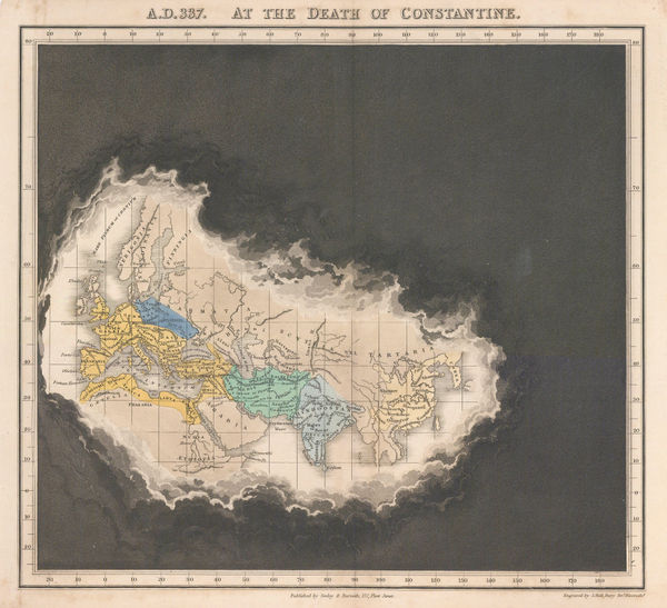
Edward Quin, A.D. 337 At the Death of Constantine, 1836£ 295.00


Page
64
of 130