-
 Edward Quin, B.C. 753 The Foundation of Rome , 1836£ 115.00
 -
Edward Quin, B.C. 301. Exhibiting the Partition of the Empire of Alexander, 1836£ 95.00
-
Edward Quin, B.C. 146. At the End of the Punic War, 1836£ 225.00
-
Edward Quin, A.D. 912. Dissolution of The Empire of Charlemagne, 1836£ 195.00
-
Edward Quin, B.C. 1491. The Exodus of The Israelites, 1836£ 115.00
-
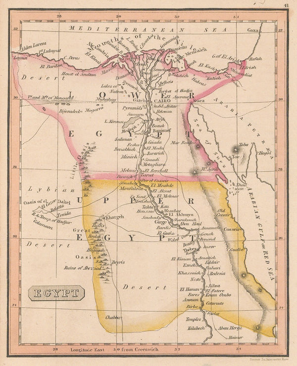
Rest Fenner, Egypt, 1836£ 75.00
-
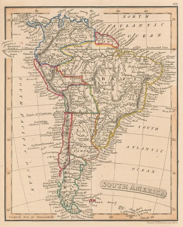
Rest Fenner, South America, 1836£ 85.00
-
Rest Fenner, Sweden and Norway, 1836£ 65.00
-
Rest Fenner, South Africa, 1836£ 85.00
-
Rest Fenner, Switzerland, 1836£ 75.00
-
George & John Cary, Cary's New Plan of London and its Vicinity, 1836£ 2,250.00
-
Rest Fenner, Polynesia and the Pacific , 1836£ 75.00
-
Rest Fenner, Persia and Arabia, 1836£ 98.00
-
Rest Fenner, Greece, 1836£ 68.00
-
Rest Fenner, The Peloponnese Peninsula, 1836£ 64.00
-
J. & C. Walker, A Geological Map of England, Wales, and Part of Scotland, 1837£ 4,500.00
-
Hansard, Montreal Island, 1837£ 525.00
-
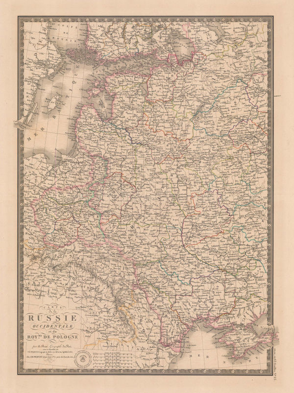
Adrien Brue, Carte de la Russie Occidentale et du Royme. de Pologne, 1837£ 185.00
-
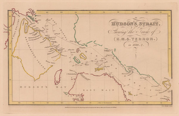
Royal Geographical Society (RGS), Hudson's Strait, 1837£ 95.00
-
Map - Illustrating the plan of the defences of the Western & North-Western Frontier, 1837Washington HoodSeries: Washington, D.C.Washington Hood, Map - Illustrating the plan of the defences of the Western & North-Western Frontier, 1837£ 625.00
-
Royal Geographical Society (RGS), Ancient settlements of Minoa and Nisea, 1837£ 58.00
-
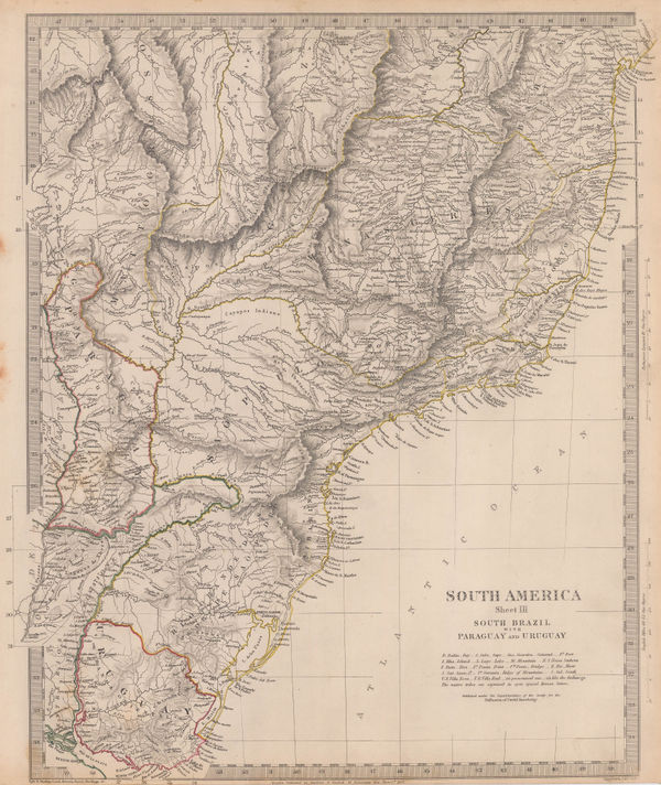
Southern Brazil, Paraguay and Uruguay, 1837Society for the Diffusion of Useful Knowledge (SDUK)Series: LondonSociety for the Diffusion of Useful Knowledge (SDUK), Southern Brazil, Paraguay and Uruguay, 1837£ 145.00
-
J. & C. Walker, Sussex, 1837£ 145.00
-
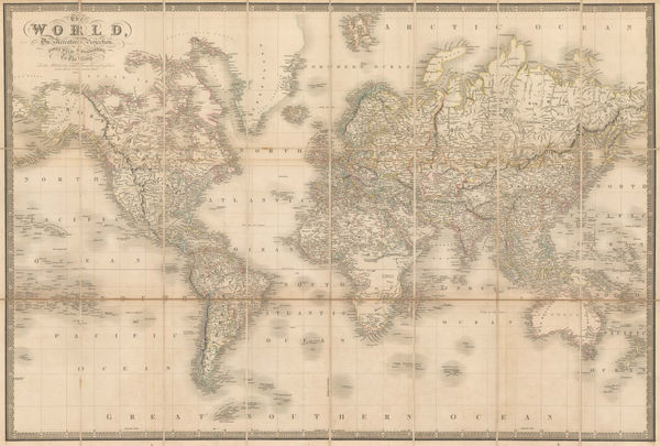
James Wyld, The World on Mercator's Projection, 1837£ 1,950.00
-
John Le Keux, Oxford, 1837£ 95.00
-
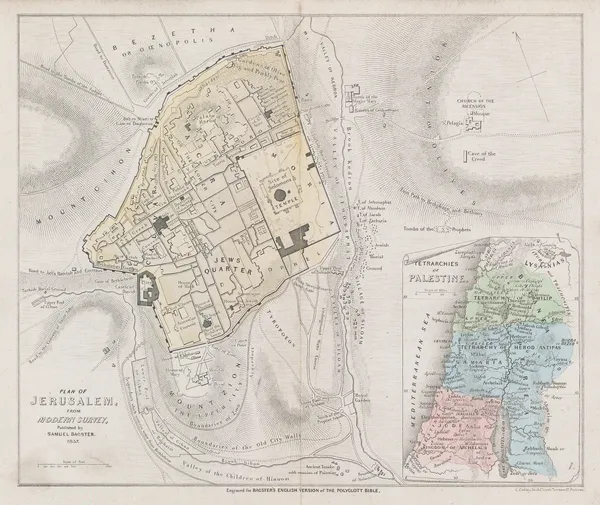
Samuel Bagster, Jerusalem, 1837£ 65.00
-
James Wellsted, Map of Oman in Arabia, 1837£ 3,850.00
-
Duncan Bradford, Herschel's Forty-Foot Reflecting Telescope, 1837 c.£ 350.00
-
Duncan Bradford, Telescopic View of the Moon, Past the Last Quadrature, 1837 c.£ 700.00
-
Duncan Bradford, Telescopic View of the Moon, The Old Moon, 1837 c.£ 700.00
-
John Lothian, Aberdeen & Banff, 1838£ 145.00
-
James Wyld, Cape District Cape of Good Hope, 1838£ 1,150.00
-
Royal Geographical Society (RGS), Capt. Alexander's Route in South Africa, 1838£ 425.00
-
Spanish Admiralty, Chart of Florida, Bahamas and Cuba , 1838£ 4,850.00
-
Clement Adrien Vincendon-Dumoulin, French sea chart of Fiji and Samoa, 1838£ 595.00
-
Alexandre Emile Lapie, Mongolia, Tibet and China, 1838£ 185.00
-
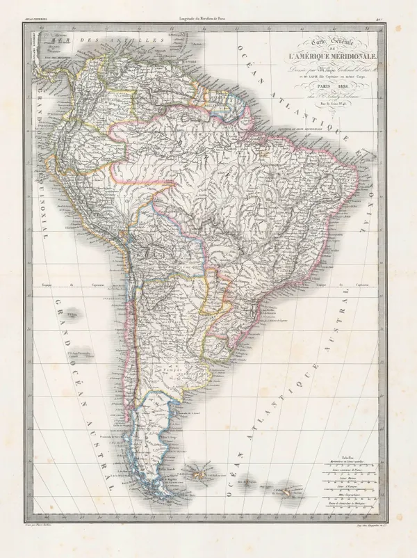
Alexandre Emile Lapie, South America, 1838£ 235.00
-
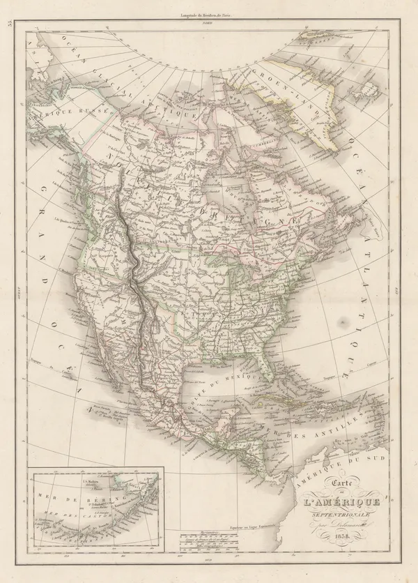
Felix Delamarche, North America, 1838£ 120.00
-
Commencement of the Roads to Holyhead, as far as (13) Stratford on Avon, Warwick, Coventry & Hinckley, 1838Richard Holmes LaurieSeries: LondonRichard Holmes Laurie, Commencement of the Roads to Holyhead, as far as (13) Stratford on Avon, Warwick, Coventry & Hinckley, 1838£ 45.00
-
James Wyld, Environs of London, 1838£ 1,550.00
-
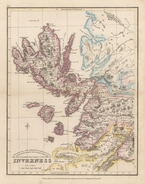
John Lothian, Inverness - Western Portion, 1838£ 175.00
-
John Lothian, Kincardine, 1838£ 125.00
-
Josiah Henshall, Tunbridge Wells, 1838£ 650.00
-
John Lothian, Peebles, 1838£ 145.00
-
John Lothian, Perth - North Portion, 1838£ 145.00
-
John Lothian, Renfrew, 1838£ 145.00
-
Route of Sir Grenville Temple from Bonah to Kostantinah, 1838Royal Geographical Society (RGS)Series: LondonRoyal Geographical Society (RGS), Route of Sir Grenville Temple from Bonah to Kostantinah, 1838£ 58.00
-
John Lothian, Roxburgh, 1838£ 145.00
-
Royal Geographical Society (RGS), Sketch of The Northern Route from Mokha to Sana, 1838£ 115.00
-
Patagonia, Chile, Tierra del Fuego and The Falklands, 1838Society for the Diffusion of Useful Knowledge (SDUK)Series: LondonSociety for the Diffusion of Useful Knowledge (SDUK), Patagonia, Chile, Tierra del Fuego and The Falklands, 1838£ 195.00
-
Society for the Diffusion of Useful Knowledge (SDUK), Spain and Portugal, 1838£ 45.00
-
Western Siberia, Independent Tartary, Khiva, Bokhara &c., 1838Society for the Diffusion of Useful Knowledge (SDUK)Series: LondonSociety for the Diffusion of Useful Knowledge (SDUK), Western Siberia, Independent Tartary, Khiva, Bokhara &c., 1838£ 120.00
-
James Wellsted, Mount Sinai Peninsula, 1838£ 395.00
-
Revd. Samuel Parker, Map of Oregon Territory, 1838£ 2,850.00
-
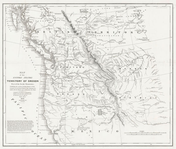
Washington Hood, Territory of Oregon West of the Rocky Mountains, 1838£ 2,450.00
-
Society for the Diffusion of Useful Knowledge (SDUK), Venice, 1838£ 545.00
-
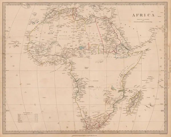
Society for the Diffusion of Useful Knowledge (SDUK), Africa, 1839£ 225.00
-
Samuel Augustus Mitchell, Southeastern United States, 1839£ 145.00
-
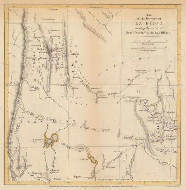
Royal Geographical Society (RGS), La Rioja province, 1839£ 65.00
-
John Colbran, Tunbridge Wells, 1839£ 250.00
-
Royal Geographical Society (RGS), Sketch map of the Iran and Iraq border, 1839£ 145.00
-
Ordnance Survey, 20 Miles Around Chesterfield, 1839£ 295.00
-
John Arrowsmith, The Colony of Western Australia, 1839£ 2,450.00
-
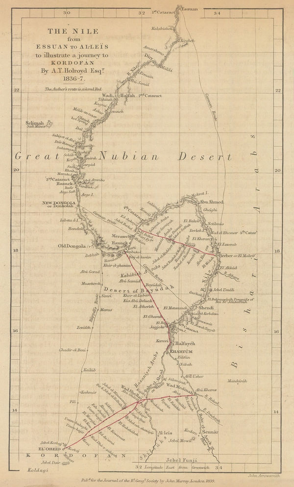
The Nile from Essuan to Al-Leis to Illustrate a Journey to Kordofan, 1839Royal Geographical Society (RGS)Series: LondonRoyal Geographical Society (RGS), The Nile from Essuan to Al-Leis to Illustrate a Journey to Kordofan, 1839£ 85.00
-
Richard Holmes Laurie, Travelling Map of England and Scotland, 1839£ 275.00
-
Royal Geographical Society (RGS), Part of Arabia Petraea and Palestine, 1839£ 525.00
-
James Wyld, Map of the Countries lying between Turkey and Burmah, 1839£ 2,450.00
-
Samuel Augustus Mitchell, Midwestern United States, 1839£ 185.00
-
Society for the Diffusion of Useful Knowledge (SDUK), Birmingham, 1839 c.£ 88.00
-
Comparative View of the Mountains, Rivers & Waterfalls of the World, 1839 c.Charles V. MoninSeries: Paris & LyonCharles V. Monin, Comparative View of the Mountains, Rivers & Waterfalls of the World, 1839 c.£ 1,750.00
-
James Harvey Weakley, A Diagram of the State of Alabama, 1840£ 385.00
-
Samuel Lewis, A Map of England and Wales, 1840£ 1,450.00
-
James Wyld, Province of Quebec, 1840£ 775.00
-
James Pigot, Cheshire, 1840£ 115.00
-
James Wyld, Kingdom of Portugal divided into Grand Provinces, 1840£ 225.00
-
James Pigot, Cornwall, 1840£ 225.00
-
James Pigot, Derbyshire, 1840£ 92.00
-
J. & C. Walker, England and Wales, 1840£ 1,250.00
-
James Wyld, European Dominions of the Ottomans or Turkey in Europe, 1840£ 795.00
-
Isenberg & Krapf's route from Tajurrah to Shoa in 1840, 1840Royal Geographical Society (RGS)Series: LondonRoyal Geographical Society (RGS), Isenberg & Krapf's route from Tajurrah to Shoa in 1840, 1840£ 58.00


Page
65
of 130