-
 Edward Hitchcock, A Geological Map of the United States and Canada, 1853£ 985.00
 -
Charles V. Monin, South America, 1853£ 98.00
-
George Philip, Austria, 1853£ 245.00
-
Charles V. Monin, Austrian or Austro-Hungarian Empire, 1853£ 52.00
-
Chart of the Northern portion of Baffin Bay to illustrate Col. Inglefields report., 1853Royal Geographical Society (RGS)Series: LondonRoyal Geographical Society (RGS), Chart of the Northern portion of Baffin Bay to illustrate Col. Inglefields report., 1853£ 145.00
-
Abe Yasuyuki, Japanese Map of the World, 1853£ 845.00
-
Charles V. Monin, United States, 1853£ 82.00
-
Heinrich C. Kiepert, Greece and the Balkans, 1853£ 485.00
-
Royal Geographical Society (RGS), Island of Chusan from Official Surveys, 1853£ 85.00
-
Carl Fredrik Ström, Sweden and Norway, 1853£ 495.00
-
Joseph Meyer, Konigreich Illyrien, 1853£ 145.00
-
John Arrowsmith, Folding map of Myanmar (Burma), 1853£ 675.00
-
Map of Passes in the Sierra Nevada, 1853United States Pacific Railroad Expeditions (USPRR)Series: Washington, D.C.United States Pacific Railroad Expeditions (USPRR), Map of Passes in the Sierra Nevada, 1853£ 575.00
-
George Matthews, Railway map of Quebec and Ontario, 1853£ 195.00
-
Joseph Meyer, Neueste Karte vom Sud-Pol, 1853£ 595.00
-
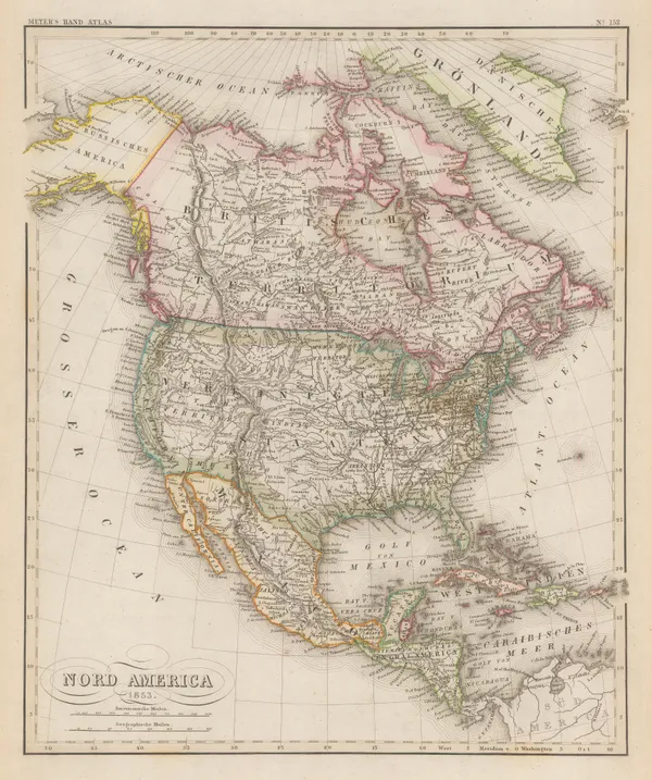
North America after the conclusion of the Mexican-American War , 1853Joseph MeyerSeries: HildburghausenJoseph Meyer, North America after the conclusion of the Mexican-American War , 1853£ 195.00
-
Charles V. Monin, Australia and the South Pacific, 1853£ 125.00
-
Royal Geographical Society (RGS), Southern part of the Isthmus of Panama, 1853£ 140.00
-
Frédéric (Federico) Mialhe, Plan of Havana, Cuba, 1853£ 825.00
-
Charles V. Monin, European Russia, 1853£ 56.00
-
Royal Geographical Society (RGS), Survey of the Aral Sea, 1853£ 98.00
-
British Admiralty, Chart of the Black Sea, 1853£ 875.00
-
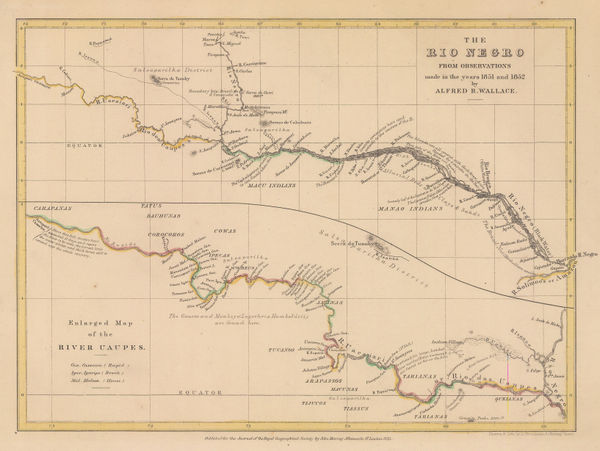
Royal Geographical Society (RGS), The Rio Negro, 1853£ 135.00
-
Society for the Diffusion of Useful Knowledge (SDUK), Toulon, 1853£ 40.00
-
Yucatan, Belize, Guatemala, Salvador, Honduras, Nicaragua and the southern states of Mexico, 1853Society for the Diffusion of Useful Knowledge (SDUK)Series: LondonSociety for the Diffusion of Useful Knowledge (SDUK), Yucatan, Belize, Guatemala, Salvador, Honduras, Nicaragua and the southern states of Mexico, 1853£ 195.00
-
Joseph Meyer, Geological Map of the United States, 1853£ 475.00
-
-
Hansard, The Languages of India, 1853£ 175.00
-
Hansard, Map of India illustrating the Native States, 1853£ 175.00
-
Hansard, Map of India Illustrating the Salt Agencies, 1853£ 75.00
-
A Plat Exhibiting the State of the Surveys in the State of Florida, 1854General Land Office (GLO)Series: St. AugustineGeneral Land Office (GLO), A Plat Exhibiting the State of the Surveys in the State of Florida, 1854£ 985.00
-
British Admiralty, Balaklava Bay, 1854£ 325.00
-
British Admiralty, Baltic Sea, 1854£ 985.00
-
Léonard Sagansan, Eastern Europe and European Russia during the Crimean War, 1854£ 1,450.00
-
Fedor von Karacsay, Carte du Pays de Montenegro, 1854£ 3,450.00
-
Andriveau-Goujon, Wall map of Europe, 1854£ 450.00
-
British Admiralty, Chart of the coast of Costa Rica, 1854£ 200.00
-
-
Carl Weiland, German map of European Russia, 1854£ 245.00
-
James Wyld, Baltic Sea, 1854£ 985.00
-
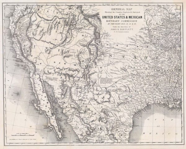
General Map Showing the Countries Explored and Surveyed by the United States & Mexican Boundary Commission, 1854John BartlettSeries: New YorkJohn Bartlett, General Map Showing the Countries Explored and Surveyed by the United States & Mexican Boundary Commission, 1854£ 950.00
-
Matthew Perry, Keelung Harbor, Taiwan, 1854£ 1,275.00
-
James Wyld, Baltic Sea & Southern Scandinavia, 1854£ 675.00
-
J. & C. Walker, Map of the Punjab, Western Himalaya, and adjoining parts of Tibet, 1854£ 2,450.00
-
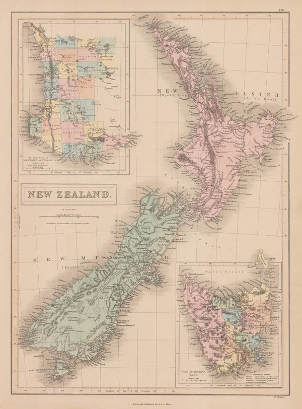
A. & C. Black, New Zealand, 1854£ 245.00
-
-
Alexander Dallas Bache, Preliminary Chart of Plymouth Harbor, 1854£ 125.00
-
James Wyld, Seat of War on the Danube, 1854£ 495.00
-
Joseph Meyer, Topographic map of South America, 1854£ 125.00
-
Society for the Diffusion of Useful Knowledge (SDUK), Sweden, Norway and Denmark, 1854£ 44.00
-
Royal Geographical Society (RGS), Map of the Northern Part of Arabia, 1854£ 145.00
-
A New Map of the Frontier Provinces of Turkey, Russia & Austria, the Black Sea &c, 1854Willmer & RogersSeries: New YorkWillmer & Rogers, A New Map of the Frontier Provinces of Turkey, Russia & Austria, the Black Sea &c, 1854£ 550.00
-
George Frederick Cruchley, Cruchley's Reduced Ordnance Map - Sheet 25, 1854£ 550.00
-
George Philip & Son Ltd., New Zealand, 1854£ 295.00
-
Royal Geographical Society (RGS), Palestine, 1854£ 295.00
-
Society for the Diffusion of Useful Knowledge (SDUK), Paris, 1854 c.£ 475.00
-
George Woolworth Colton, Alabama, 1855£ 120.00
-
George Woolworth Colton, Arkansas, 1855£ 150.00
-
Joseph Hutchins Colton, Canada East or Lower Canada and New Brunswick, 1855£ 95.00
-
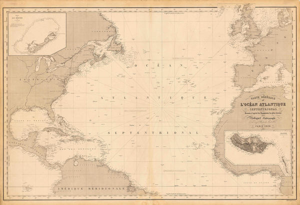
Aimé Robiquet, Chart of the North Atlantic Ocean, 1855£ 785.00
-
George Woolworth Colton, Colton's New Hampshire, 1855£ 85.00
-
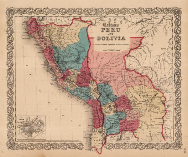
George Woolworth Colton, Colton's Peru and Bolivia, 1855£ 75.00
-
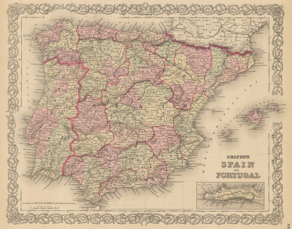
George Woolworth Colton, Colton's Spain and Portugal, 1855£ 90.00
-
Justus Perthes, Prince Waldemar of Prussia's route to Kathmandu, 1855£ 225.00
-
John Tallis, England and Wales, 1855£ 495.00
-
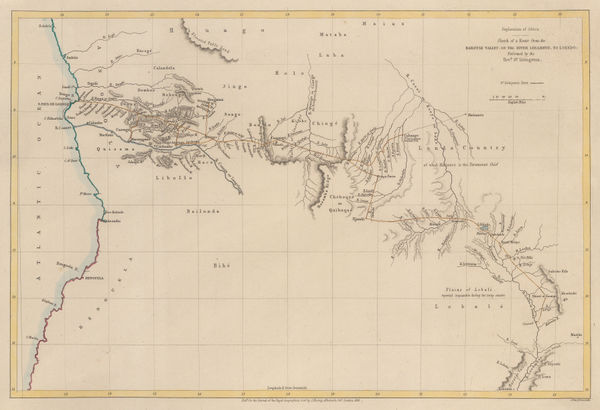
Royal Geographical Society (RGS), Livingstone's route from Angola to the Zambezi, 1855£ 175.00
-
From Fort Smith to the Rio Grande, 1855United States Pacific Railroad Expeditions (USPRR)Series: Washington, D.C.United States Pacific Railroad Expeditions (USPRR), From Fort Smith to the Rio Grande, 1855£ 1,150.00
-
From the Valley of Green River to the Great Salt Lake, 1855United States Pacific Railroad Expeditions (USPRR)Series: Washington, D.C.United States Pacific Railroad Expeditions (USPRR), From the Valley of Green River to the Great Salt Lake, 1855£ 585.00
-
Geological Map of the Mississippi River to the Pacific Ocean, 1855United States Pacific Railroad Expeditions (USPRR)Series: Washington, D.C.United States Pacific Railroad Expeditions (USPRR), Geological Map of the Mississippi River to the Pacific Ocean, 1855£ 775.00
-
Geological Section from the Mississippi River to the Pacific Ocean, 1855United States Pacific Railroad Expeditions (USPRR)Series: Washington, D.C.United States Pacific Railroad Expeditions (USPRR), Geological Section from the Mississippi River to the Pacific Ocean, 1855£ 675.00
-
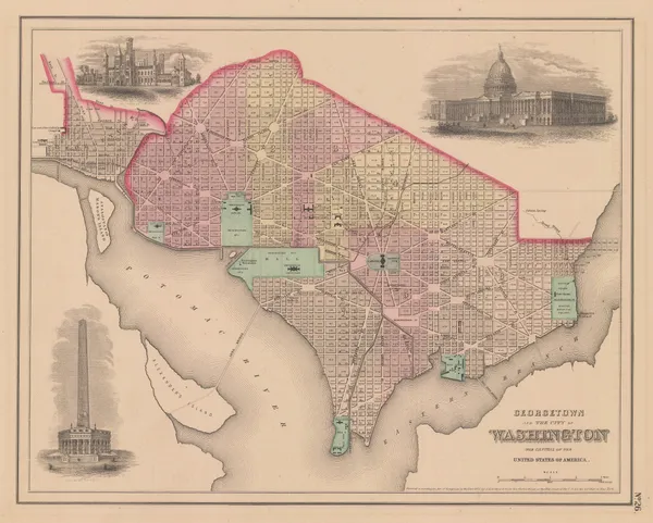
Joseph Hutchins Colton, Georgetown and the City of Washington, 1855£ 445.00
-
John Tallis, Netherlands, 1855£ 195.00
-
Joseph Hutchins Colton, Iowa, 1855£ 165.00
-
Karl von Spruner, Historical map of the Eastern Caliphate, 1855£ 295.00
-
George Woolworth Colton, Kentucky and Tennessee, 1855£ 125.00
-
Joseph Hutchins Colton, Lake Superior and the Northern Part of Michigan, 1855£ 185.00
-
Joseph Hutchins Colton, Maine, 1855£ 195.00
-
Map No. 2 - From Great Salt Lake to the Humboldt Mountains, 1855United States Pacific Railroad Expeditions (USPRR)Series: Washington, D.C.United States Pacific Railroad Expeditions (USPRR), Map No. 2 - From Great Salt Lake to the Humboldt Mountains, 1855£ 425.00
-
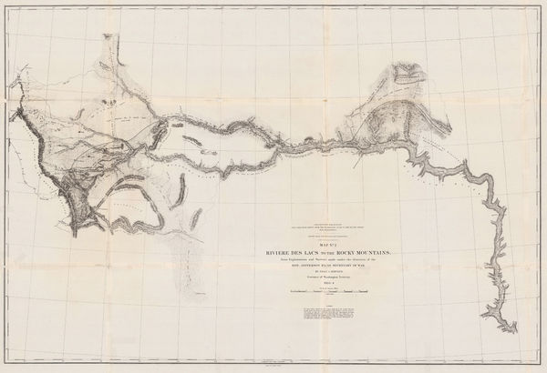
Map No. 2 - Riviere des Lacs to the Rocky Mountains, 1855United States Pacific Railroad Expeditions (USPRR)Series: Washington, D.C.United States Pacific Railroad Expeditions (USPRR), Map No. 2 - Riviere des Lacs to the Rocky Mountains, 1855£ 825.00
-
Map No. 3 - From the Humboldt Mountains to the Mud Lakes, 1855United States Pacific Railroad Expeditions (USPRR)Series: Washington, D.C.United States Pacific Railroad Expeditions (USPRR), Map No. 3 - From the Humboldt Mountains to the Mud Lakes, 1855£ 385.00


Page
76
of 130