-
 Map Showing the Line of March from the Coast to Adigerat, 1868Royal Geographical Society (RGS)Series: LondonRoyal Geographical Society (RGS), Map Showing the Line of March from the Coast to Adigerat, 1868£ 195.00
 -
Antonio Vallardi, City plan of Palermo, 1868£ 385.00
-
James Sandby Padley, Lincoln, 1868£ 1,950.00
-
Sketch Map Showing Proposed Communication Between Canada & British Columbia, 1868Royal Geographical Society (RGS)Series: LondonRoyal Geographical Society (RGS), Sketch Map Showing Proposed Communication Between Canada & British Columbia, 1868£ 58.00
-
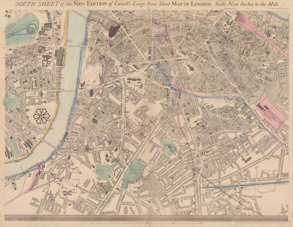
John Cassell, Lambeth, Vauxhall, Borough, Southwark & Kennington, 1868£ 345.00
-
Justus Perthes, Sketch map of the Ethiopian Highlands, 1868£ 78.00
-
James Imray, The Coast of the Cape Colony, 1868£ 2,250.00
-
Royal Geographical Society (RGS), Wadela and Dalanta Plateux and Magdala, 1868£ 195.00
-
Ordnance Survey, Geological map of Western Surrey, 1868£ 375.00
-
John Cassell, Paddington, Bayswater, Marylebone & Regent's Park, 1868£ 775.00
-
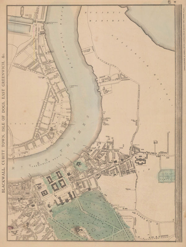
John Cassell, Greenwich, Isle of Dogs & Greenwich Peninsula, 1868£ 325.00
-
Justus Perthes, Arctic & Antarctic Discoveries, 1868£ 295.00
-
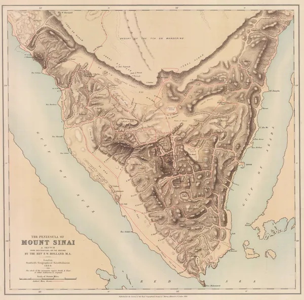
Royal Geographical Society (RGS), Sinai Peninsula, 1868£ 345.00
-
John Cassell, Kensal Green, Kilburn & Notting Hill, 1868£ 575.00
-
Justus Perthes, Tibet, 1868£ 475.00
-
Justus Perthes, French Conquest of Cochinchina, 1868£ 195.00
-
Royal Geographical Society (RGS), Armenia, Kurdistan and Upper Mesopotamia, 1868£ 295.00
-
Justus Perthes, Map of the Baja California Peninsula, 1868£ 325.00
-
Royal Geographical Society (RGS), Pundit Map of the Route from Nepal to Lhasa, 1868£ 575.00
-
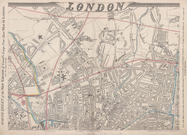
John Cassell, North London, 1868 (c.)£ 565.00
-
Map of the United States of America, the British Provinces, Mexico and the West Indies, 1868 c.George Woolworth ColtonSeries: New YorkGeorge Woolworth Colton, Map of the United States of America, the British Provinces, Mexico and the West Indies, 1868 c.£ 2,850.00
-
Justus Perthes, Egypt and Nubia (Sudan), 1869£ 40.00
-
Aleph, Denmark, 1869£ 650.00
-
Justus Perthes, Die Meeres-Temperatur des Grönländischen Meeres, 1869£ 88.00
-
Justus Perthes, Islands of the Kingdom of Tonga, 1869£ 45.00
-
Aleph, England, 1869£ 1,950.00
-
Aleph, Scarce caricature map of France, 1869£ 1,350.00
-
Aleph, Holland and Belgium, 1869£ 1,250.00
-
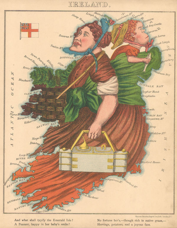
Aleph, Scarce caricature map of Ireland, 1869£ 1,950.00
-
Aleph, Scarce caricature map of Italy, 1869£ 1,250.00
-
Aleph, Caricature map of Prussia, 1869£ 750.00
-
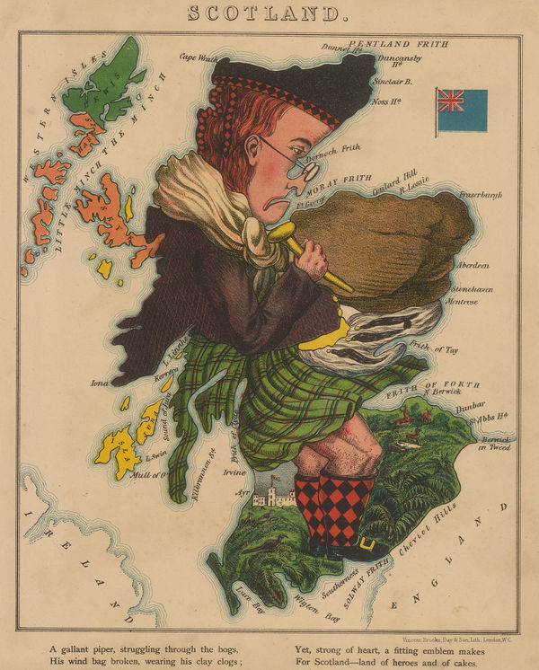
Aleph, Scotland, 1869£ 1,850.00
-
Royal Geographical Society (RGS), The South-Polar Regions, 1869£ 950.00
-
Aleph, Wales, 1869£ 1,350.00
-
Watson's New Map of the Western States Territories, Mexico, and Central America, 1869Gaylord WatsonSeries: New YorkGaylord Watson, Watson's New Map of the Western States Territories, Mexico, and Central America, 1869£ 4,500.00
-
Justus Perthes, Missionary Map of South Africa, 1869£ 75.00
-
Ordnance Survey, Knightsbridge, Kensington & Brompton, 1869£ 3,500.00
-
Justus Perthes, Vancouver Island, 1869£ 425.00
-
Justus Perthes, Arctic Russia, Wrangel Island & the Bering Strait, 1869£ 125.00
-
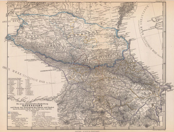
Justus Perthes, The Caucasus, 1869£ 175.00
-
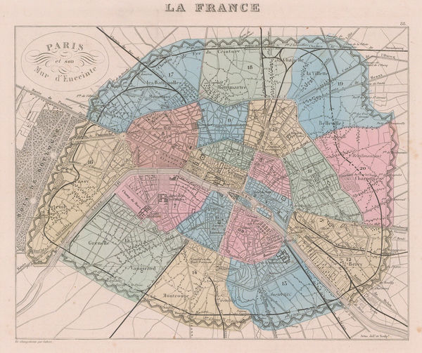
Alexandre Vuillemin, Paris showing the Thiers Wall, 1869£ 250.00
-
William Gifford Palgrave, Al-Hofuf, 1869£ 195.00
-
James Wyld, Wyld's New Plan of London & Its Vicinity, 1869£ 3,750.00
-
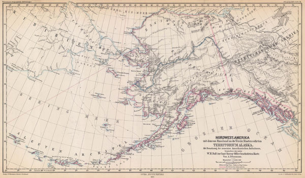
Justus Perthes, Alaska, 1869£ 295.00
-
Bernhard Studer, Geological map of Switzerland, 1869 c.£ 1,650.00
-
Royal Geographical Society (RGS), Chart of Rapa-Nui or Easter Island, 1870£ 275.00
-
Justus Perthes, Christian Mission in the Pacific Ocean, 1870£ 50.00
-
Dutch edition of a rare German caricature map of Europe during the Franco-Prussian War, 1870Arnold NeumannSeries: HaarlemArnold Neumann, Dutch edition of a rare German caricature map of Europe during the Franco-Prussian War, 1870£ 3,500.00
-
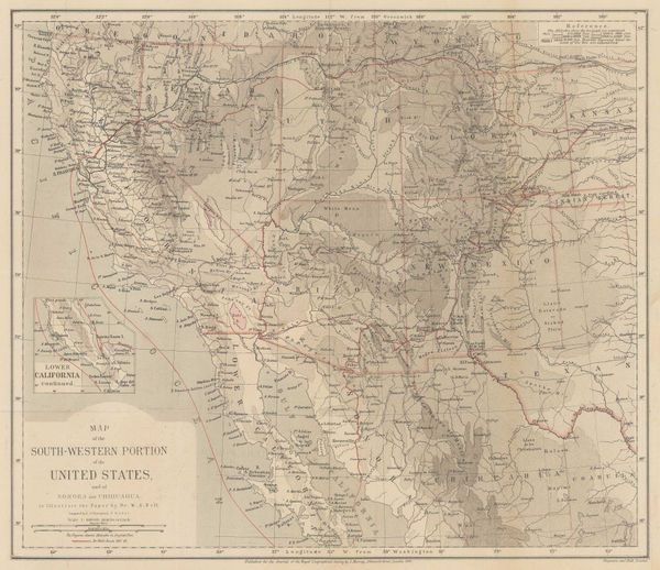
Map of the South-Western Portion of the United States, 1870Royal Geographical Society (RGS)Series: LondonRoyal Geographical Society (RGS), Map of the South-Western Portion of the United States, 1870£ 375.00
-
Royal Geographical Society (RGS), Map to Accompany the Notes on Manchuria, 1870£ 175.00
-
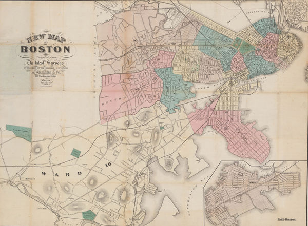
A. Williams & Co., New Map of Boston from the Latest Surveys, 1870£ 1,450.00
-
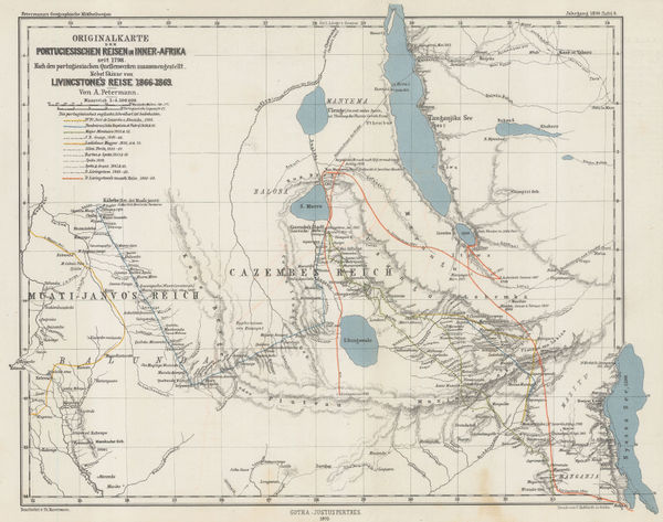
Justus Perthes, Exploration of Zambia, Malawi & Tanzania, 1870£ 78.00
-
Justus Perthes, Interior of South Africa, Botswana, and Zimbabwe, 1870£ 345.00
-
Justus Perthes, Russian Lapland, 1870£ 165.00
-
A. Simon, Plan of the docks of Seville, 1870£ 72.00
-
Sketch Map Showing the Mineral & Silk Districts of the Province of Shan-Tung (China), 1870Royal Geographical Society (RGS)Series: LondonRoyal Geographical Society (RGS), Sketch Map Showing the Mineral & Silk Districts of the Province of Shan-Tung (China), 1870£ 265.00
-
Surface Temperatures of the North Atlantic between Shetland & Greenland, 1870Royal Geographical Society (RGS)Series: LondonRoyal Geographical Society (RGS), Surface Temperatures of the North Atlantic between Shetland & Greenland, 1870£ 155.00
-
Justus Perthes, South Australia between Lake Eyre and Lake Blanche, 1870£ 52.00
-
Ordnance Survey, Knightsbridge & Belgravia, 1870£ 1,850.00
-
Justus Perthes, Northern Chile, 1870£ 195.00
-
Benjamin Rees Davies, Davies's New Map of London, 1870£ 2,250.00
-
R.E. Peach, Bath, 1870£ 195.00
-
Aime Humbert, Tokyo, 1870£ 645.00
-
Justus Perthes, Arctic Temperature Maps, 1870£ 145.00
-
Royal Geographical Society (RGS), Caravan routes in Kenya and Tanzania, 1870£ 845.00
-
James Wyld, The United States, 1870 (c.)£ 1,250.00
-
J.G. Bartholomew, Arabia, 1870 c£ 195.00
-
Alvin J. Johnson, Western States of the USA, 1870 c£ 645.00
-
W.H. Smith & Son, Environs of London, 1870 c£ 295.00
-
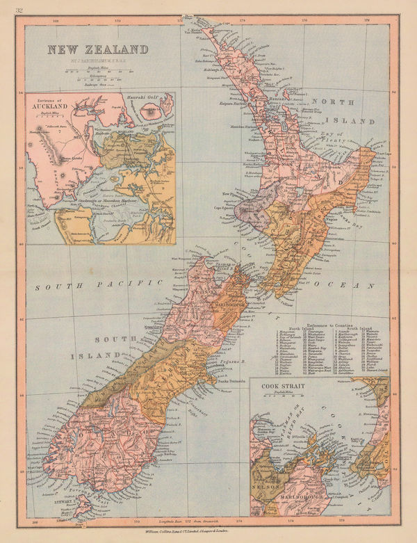
William Collins, New Zealand, 1870 c£ 115.00
-
Thomas Martyn, A New and Accurate Map of the County of Cornwall, 1870 c.£ 1,550.00
-
G. Woldermann, Folding wall map of Africa, 1870 c.£ 1,450.00
-
J. Goubaud, Austrian or Austro-Hungarian Empire, 1870 c.£ 55.00
-
John Dower, Canada &c., 1870 c.£ 78.00
-
Archibald Fullarton, Canada with part of the United States, 1870 c.£ 125.00
-
Heinrich C. Kiepert, Die Vereinigten Staaten von Nord America nebst Canada, 1870 c.£ 445.00
-
Charton, Cameroon to South Sudan, 1870 c.£ 48.00
-
Geological Map of the Lead Region in the States of Wisconsin, Illinois and Iowa, 1870 c.J.D. WhitneyJ.D. Whitney, Geological Map of the Lead Region in the States of Wisconsin, Illinois and Iowa, 1870 c.£ 585.00
-
Ferdinand Hayden, Map of the Shoshone Geysers, 1870 c.£ 395.00
-
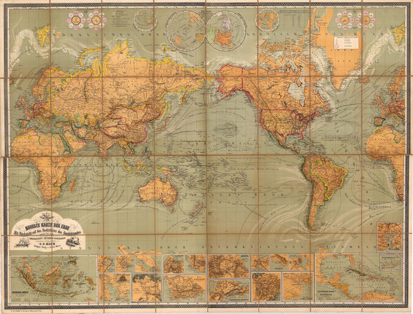
Julius Maier, Neueste Karte der Erde, 1870 c.£ 2,650.00


Page
84
of 130