-
 Justus Perthes, North America, 1870 c.£ 80.00
 -
Archibald Fullarton, Oceania and Pacific Ocean, 1870 c.£ 115.00
-
Archibald Fullarton, Quebec City and environs, 1870 c.£ 45.00
-
Justus Perthes, South America showing European possessions, 1870 c.£ 55.00
-
J. Berg, Tellurian, 1870 c.£ 5,250.00
-
Blackie & Son, Sumatra, Borneo, and the Philippines, 1870 c.£ 225.00
-
Royal Geographical Society (RGS), Milos, Anti-Milos, Kimolos & Poliegos, 1870 c.£ 125.00
-
Archibald Fullarton, The West Indies, 1870 c.£ 250.00
-
Archibald Fullarton, Southeast United States, 1870 c.£ 78.00
-
Archibald Fullarton, United States - The North Central Section, 1870 c.£ 75.00
-
Justus Perthes, The West Indies and Central America, 1870 c.£ 85.00
-
James Wyld, A New Map of the Country Twenty-Five Miles Round London, 1870 c.£ 2,250.00
-
Society for the Diffusion of Useful Knowledge (SDUK), Asia Minor, 1870 c.£ 145.00
-
James Reynolds, Methods of Ascertaining the Latitude, 1870 c.£ 125.00
-
Pawson & Brailsford, Sheffield, 1870 c.£ 250.00
-
Archibald Fullarton, Australia and New Zealand, 1870 c.£ 525.00
-
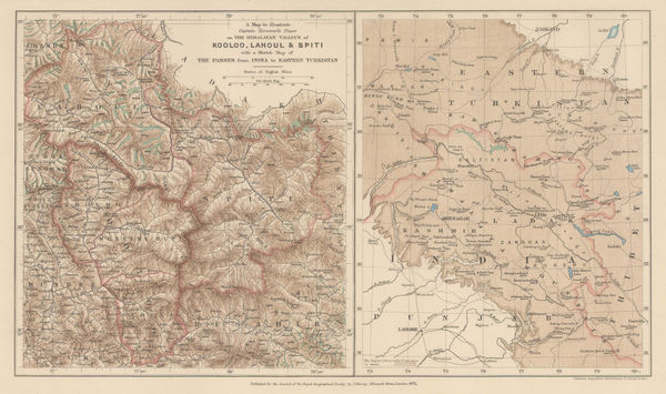
A Map to Illustrate Captain Harcourts Paper on the Himalayan Valleys of Kooloo, Lahoul & Spiti, 1871Royal Geographical Society (RGS)Series: LondonRoyal Geographical Society (RGS), A Map to Illustrate Captain Harcourts Paper on the Himalayan Valleys of Kooloo, Lahoul & Spiti, 1871£ 325.00
-
Alexandre Vuillemin, Folding map of Algeria, 1871£ 295.00
-
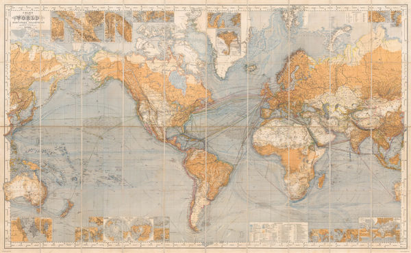
Justus Perthes, Chart of the World on Mercators Projection, 1871£ 3,250.00
-
Justus Perthes, Indigenous Map of Central and Midwest USA, 1871£ 125.00
-
Justus Perthes, G.W. Hayward’s journey from Leh to Kashgar, 1871£ 98.00
-
Spanish Admiralty, Spanish Admiralty chart of the Chesapeake Bay, 1871£ 1,450.00
-
Royal Geographical Society (RGS), Kanto Region, Japan, 1871£ 145.00
-
Royal Geographical Society (RGS), Overland route from Perth to Adelaide , 1871£ 695.00
-
Map to accompany Mr Ney Elias' paper on the New Course of the Yellow River, 1871Royal Geographical Society (RGS)Series: LondonRoyal Geographical Society (RGS), Map to accompany Mr Ney Elias' paper on the New Course of the Yellow River, 1871£ 165.00
-
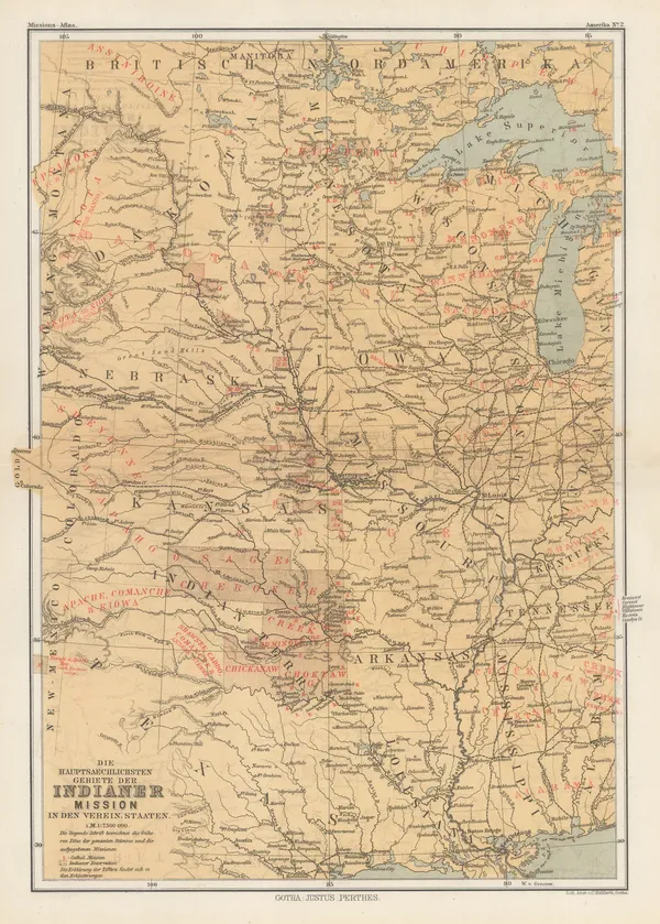
Justus Perthes, North America showing missions and reservations, 1871£ 55.00
-
John Dower, Pacific Ocean, 1871£ 80.00
-
John Dower, Russia in Asia, 1871£ 55.00
-
Sketch Map of Mr. Baines' Routes Between the Limpopo and Zambesi Rivers, 1871Royal Geographical Society (RGS)Series: LondonRoyal Geographical Society (RGS), Sketch Map of Mr. Baines' Routes Between the Limpopo and Zambesi Rivers, 1871£ 150.00
-
John Dower, Spain and Portugal, 1871£ 58.00
-
Edward Stanford, Stanford's Library Map of Europe, 1871£ 3,950.00
-
Justus Perthes, French military expeditions in Morocco, 1872£ 68.00
-
Justus Perthes, German Exploration in Gabon, 1872£ 88.00
-
Justus Perthes, J.M. Gilmore's Expeditions in Southwest Queensland, 1872£ 68.00
-
Justus Perthes, Western Mongolia, 1872£ 145.00
-
Map of Route from The Tati Settlement to Delagoa Bay, 1872Royal Geographical Society (RGS)Series: LondonRoyal Geographical Society (RGS), Map of Route from The Tati Settlement to Delagoa Bay, 1872£ 145.00
-
Royal Geographical Society (RGS), Map of the Southern Coast of Arabia, 1872£ 135.00
-
Justus Perthes, Western Bulgaria and eastern Serbia, 1872£ 68.00
-
Justus Perthes, Yemen, 1872£ 245.00
-
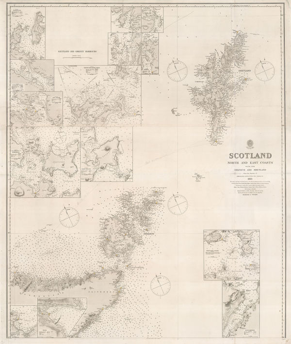
British Admiralty, Orkneys and Shetland Isles, 1872£ 325.00
-
Railway Map of the England and Wales Shewing the Districts Served by Each Railway System, 1872Edward StanfordSeries: LondonEdward Stanford, Railway Map of the England and Wales Shewing the Districts Served by Each Railway System, 1872£ 3,950.00
-
Royal Geographical Society (RGS), Route Map of the Tulul el Safa, 1872£ 185.00
-
M.E. Daw, The British Isles, 1872£ 3,850.00
-
Royal Geographical Society (RGS), Sakhalin, 1872£ 245.00
-
Royal Geographical Society (RGS), Sketch map of Hokkaido, 1872£ 185.00
-
Royal Geographical Society (RGS), Western Australia, Hampton Plains, 1872£ 195.00
-
Ordnance Survey, Wimborne, Blandford, Shaftesbury, Lynhurst, Salisbury & Ringwood, 1872£ 295.00
-
Ordnance Survey, Warminster, Devizes, Marlborough & Amesbury, 1872£ 195.00
-
Society for Promoting Christian Knowledge (SPCK), Great Britain & Ireland, 1872£ 2,250.00
-
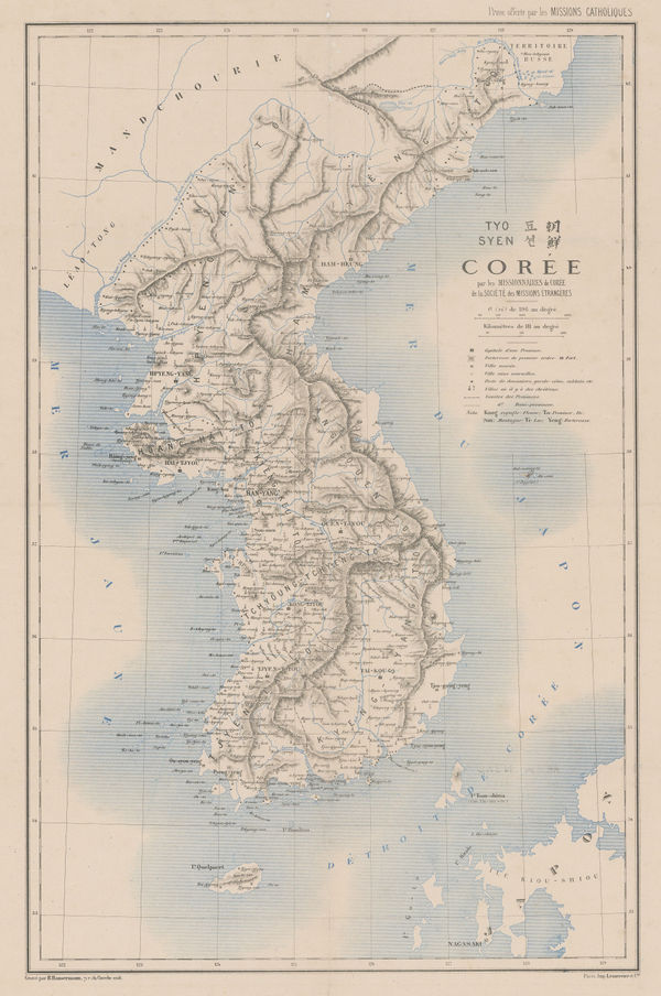
R. P. Carceri, Korea, 1872£ 1,950.00
-
Alvin J. Johnson, New York and Brooklyn, 1872 c£ 825.00
-
-
A Sketch map of Part of South Eastern Africa to Illustrate the Journeys of Dr Lacerda (1798) the Pombeiros (1806-11) and Major Monteiro (1831-32), 1873Royal Geographical Society (RGS)Series: LondonRoyal Geographical Society (RGS), A Sketch map of Part of South Eastern Africa to Illustrate the Journeys of Dr Lacerda (1798) the Pombeiros (1806-11) and Major Monteiro (1831-32), 1873£ 395.00
-
Carl Muller, North Africa coast during the Classical period, 1873£ 50.00
-
E. Coutaut, Wine map of Gironde, 1873£ 4,250.00
-
James Wyld, The Caspian Sea and Environs during the Russo-Khivan War, 1873£ 925.00
-
Royal Geographical Society (RGS), Map of the Vicinity of Aden, 1873£ 175.00
-
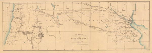
Projected railway route from Buenos Aires to Chile, 1873Royal Geographical Society (RGS)Series: LondonRoyal Geographical Society (RGS), Projected railway route from Buenos Aires to Chile, 1873£ 195.00
-
Royal Geographical Society (RGS), Kyoto to Tokyo route map, 1873£ 165.00
-
Justus Perthes, North Maluku, Salawati and Waigeu, Indonesia, 1873£ 125.00
-
Justus Perthes, Taimyr Peninsula in the Russian Arctic, 1873£ 245.00
-
Sketch Map of the Countries Referred to in the Zeno Narrative, 1873Royal Geographical Society (RGS)Series: LondonRoyal Geographical Society (RGS), Sketch Map of the Countries Referred to in the Zeno Narrative, 1873£ 145.00
-
Justus Perthes, Khiva, Uzbekistan, 1873£ 125.00
-
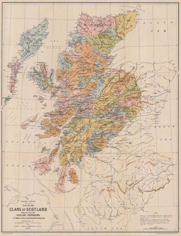
W. & A.K. Johnston, Map of the Clans of Scotland, 1873£ 950.00
-
Royal Geographical Society (RGS), Western Mongolia, 1873£ 525.00
-
James Wyld, Asia, 1874£ 65.00
-
Samuel Augustus Mitchell, County Map of Florida, 1874£ 145.00
-
Samuel Augustus Mitchell, County Map of the State of Illinois, 1874£ 115.00
-
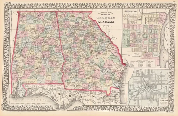
Samuel Augustus Mitchell, County map of the States of Georgia and Alabama, 1874£ 195.00
-
James Wyld, Norway & Sweden, 1874£ 125.00
-
D. Appleton & Company, Map of Boston, 1874£ 375.00
-
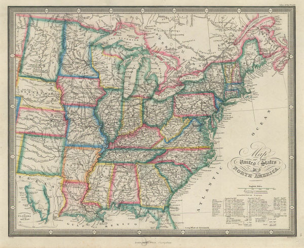
James Wyld, Map of the United States of North America, 1874£ 185.00
-
Map to illustrate Explorations in South Africa from Walvische Bay to Lake Ngami by C Andersson., 1874Royal Geographical Society (RGS)Series: LondonRoyal Geographical Society (RGS), Map to illustrate Explorations in South Africa from Walvische Bay to Lake Ngami by C Andersson., 1874£ 275.00
-
James Wyld, North America, 1874£ 125.00
-
James Wyld, Republics of Peru and Bolivia, 1874£ 78.00
-
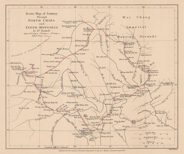
Route Map of Journey Through North China and Inner Mongolia, 1874Royal Geographical Society (RGS)Series: LondonRoyal Geographical Society (RGS), Route Map of Journey Through North China and Inner Mongolia, 1874£ 110.00
-
James Wyld, Russia in Asia, 1874£ 77.00
-
Royal Geographical Society (RGS), Slave Caravan Route, 1874£ 195.00
-
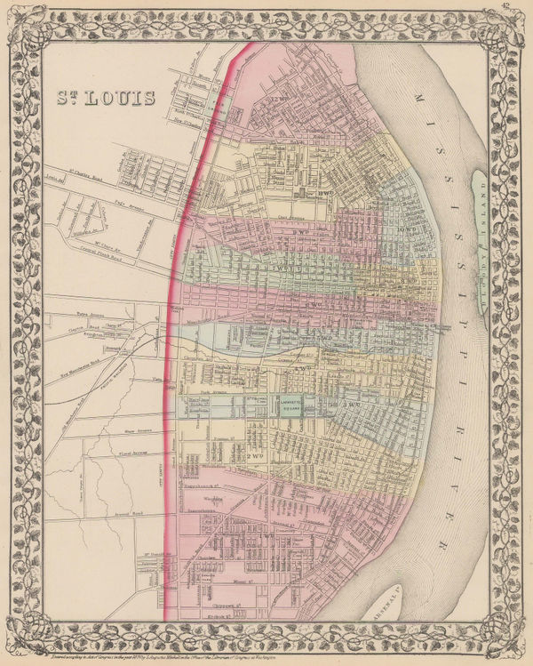
Samuel Augustus Mitchell, St Louis, 1874£ 195.00
-
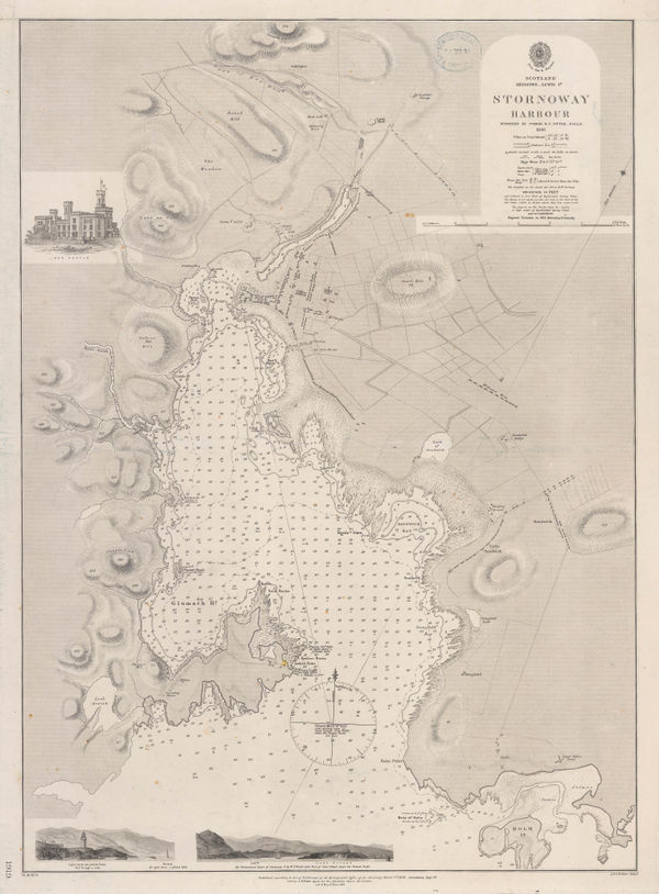
British Admiralty, Stornoway Harbour, 1874£ 150.00


![Henry L. Bryant, "Celestial Indicator" [Solar System Model], 1872 c.](https://static-assets.artlogic.net/w_600,c_limit,f_auto,fl_lossy,q_auto/artlogicstorage/themaphouse/images/view/5a601288d656f90361d6b0b76b015c12j/themaphouse-henry-l.-bryant-celestial-indicator-solar-system-model-1872-c..jpg)


Page
85
of 130