-
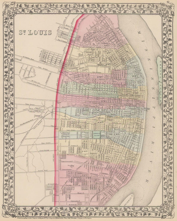
 Samuel Augustus Mitchell, St Louis, 1874£ 195.00
 -
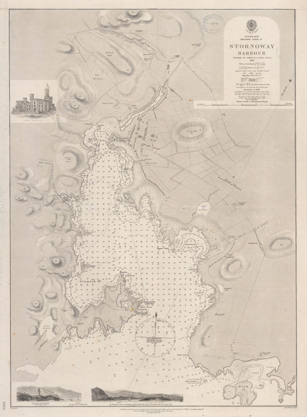
British Admiralty, Stornoway Harbour, 1874£ 150.00
-
Justus Perthes, Ubersicht von F. Kanitz Reisen in Bulgarien 1870-1874., 1874£ 68.00
-
James Wyld, Tasmania, 1874£ 155.00
-
James Wyld, Western Australia, 1874£ 145.00
-
Edward Stanford, Victoria Park, Hackney, Stratford & Homerton, 1874£ 325.00
-
James Wyld, Map of the County of Surrey, 1874£ 585.00
-
Justus Perthes, German map of Central Persia (Iran), 1874£ 68.00
-
Justus Perthes, Gosse & Warburton's Expeditions in Western Australia, 1874£ 175.00
-
Royal Geographical Society (RGS), New Guinea, 1874£ 145.00
-
Justus Perthes, The Route of the Challenger Expedition, 1874£ 385.00
-
Edward Stanford, Stanford's Portable Map of India, 1874£ 985.00
-
Samuel Augustus Mitchell, County Map of Utah and Nevada, 1874 c.£ 145.00
-
Newton Horace Winchell, A Geological Map of The Black Hills, 1875£ 585.00
-
Bokhara, Afghanistan, Beloochistan, &c., 1875Society for the Diffusion of Useful Knowledge (SDUK)Series: LondonSociety for the Diffusion of Useful Knowledge (SDUK), Bokhara, Afghanistan, Beloochistan, &c., 1875£ 325.00
-
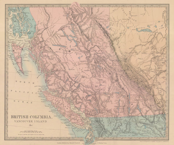
Society for the Diffusion of Useful Knowledge (SDUK), British Columbia & Vancouver Island, 1875£ 385.00
-
Justus Perthes, Northwest Switzerland, 1875£ 145.00
-
Jules Marcou, Geological Map of the World, 1875£ 4,250.00
-
Royal Geographical Society (RGS), Central Asia, 1875£ 550.00
-
Chart of Europe Shewing the Wrecks & Casualties to British Vessels Elsewhere than on the Coast of United Kingdom, 1875Board of Trade Wreck RegisterSeries: LondonBoard of Trade Wreck Register, Chart of Europe Shewing the Wrecks & Casualties to British Vessels Elsewhere than on the Coast of United Kingdom, 1875£ 385.00
-
Board of Trade Wreck Register, Shipwreck Chart of Britain & Ireland, 1875£ 425.00
-
Chart Shewing the Wrecks & Casualties on the Coasts of England & Wales, 1875Board of Trade Wreck RegisterSeries: LondonBoard of Trade Wreck Register, Chart Shewing the Wrecks & Casualties on the Coasts of England & Wales, 1875£ 345.00
-
Society for the Diffusion of Useful Knowledge (SDUK), China, 1875£ 275.00
-
James Mackenzie Maclean, City plan of Mumbai (Bombay), 1875£ 595.00
-
Society for the Diffusion of Useful Knowledge (SDUK), Empire of Japan, 1875£ 545.00
-
Board of Trade Wreck Register, Shipwreck Chart of Britain & Ireland, 1875£ 425.00
-
Reginald A.F. Murray, Geological Map of Gipps Land, 1875£ 825.00
-
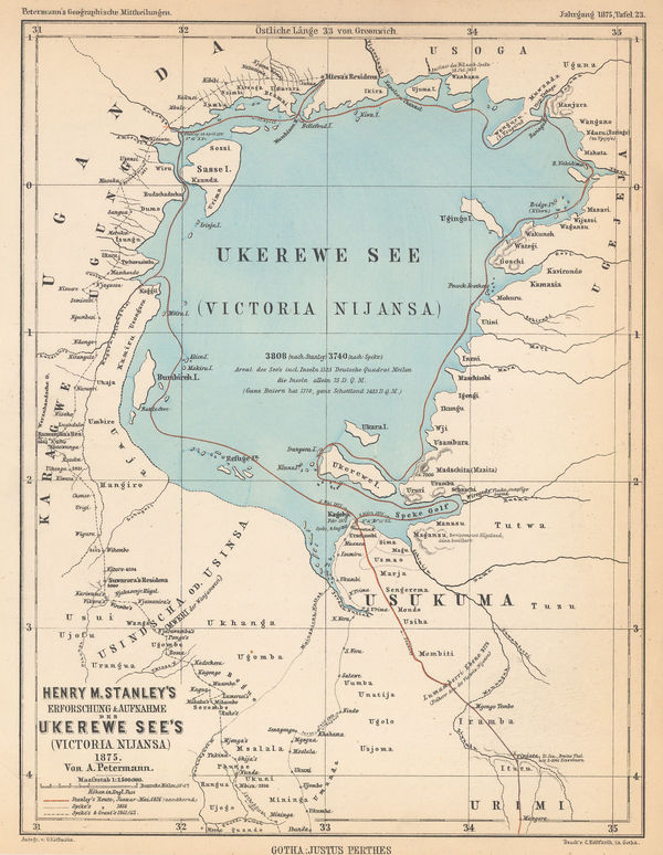
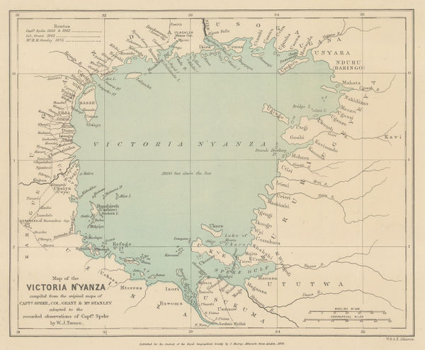
Justus Perthes, Lake Victoria according to Stanley, Speke & Grant, 1875£ 125.00
-
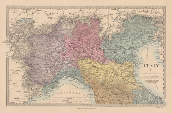
Society for the Diffusion of Useful Knowledge (SDUK), Northern Italy, 1875£ 98.00
-
Justus Perthes, Lake Eyre and environs, J. W. Lewis' expedition, 1875£ 64.00
-
Royal Geographical Society (RGS), Khanate of Khiva, 1875£ 325.00
-
Society for the Diffusion of Useful Knowledge (SDUK), London, 1875£ 1,350.00
-
Map Showing Routes of Native Explorers in Tibet and Nepal, 1875Royal Geographical Society (RGS)Series: LondonRoyal Geographical Society (RGS), Map Showing Routes of Native Explorers in Tibet and Nepal, 1875£ 745.00
-
Southern Ontario with parts of New York, Pennsylvania, and Michigan, 1875Society for the Diffusion of Useful Knowledge (SDUK)Series: LondonSociety for the Diffusion of Useful Knowledge (SDUK), Southern Ontario with parts of New York, Pennsylvania, and Michigan, 1875£ 245.00
-
Justus Perthes, Expeditions in the Libyan Desert, 1875£ 185.00
-
Alfred W. Oborne, Wimbledon Park Estate, 1875£ 885.00
-
Edward Stanford, Railway and Road Map of England and Wales, 1875£ 485.00
-
Royal Geographical Society (RGS), Route Map of the Gasa Country, 1875£ 175.00
-
Society for the Diffusion of Useful Knowledge (SDUK), South Africa, 1875£ 345.00
-
Royal Geographical Society (RGS), Southeast Madagascar, 1875£ 195.00
-
Justus Perthes, Wall map of Australia, 1875£ 1,850.00
-
Society for the Diffusion of Useful Knowledge (SDUK), Australia, 1875£ 595.00
-
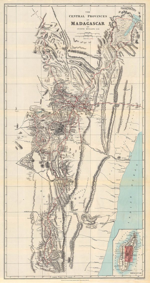
Royal Geographical Society (RGS), Central Madagascar and Anakaratra volcano, 1875£ 345.00
-
Society for the Diffusion of Useful Knowledge (SDUK), The Islands of New Zealand, 1875£ 625.00
-
The Turkish Empire in Europe and Asia, 1875Society for the Diffusion of Useful Knowledge (SDUK)Series: LondonSociety for the Diffusion of Useful Knowledge (SDUK), The Turkish Empire in Europe and Asia, 1875£ 295.00
-
Justus Perthes, The Colony of Western Australia, 1875£ 125.00
-
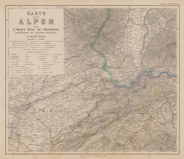
Justus Perthes, Swiss and Italian Alps, 1875£ 185.00
-
Constellations - Andromeda, Capricorn, Pegasus & Cetus, 1875Society for the Diffusion of Useful Knowledge (SDUK)Series: LondonSociety for the Diffusion of Useful Knowledge (SDUK), Constellations - Andromeda, Capricorn, Pegasus & Cetus, 1875£ 65.00
-
Constellations - Sagittarius, Scorpio, Libra & Capricorn, 1875Society for the Diffusion of Useful Knowledge (SDUK)Series: LondonSociety for the Diffusion of Useful Knowledge (SDUK), Constellations - Sagittarius, Scorpio, Libra & Capricorn, 1875£ 65.00
-
Constellations - Southern Hemisphere, 1875Society for the Diffusion of Useful Knowledge (SDUK)Series: LondonSociety for the Diffusion of Useful Knowledge (SDUK), Constellations - Southern Hemisphere, 1875£ 65.00
-
Justus Perthes, Salzburg, 1875£ 125.00
-
Justus Perthes, Central Chile, 1875£ 78.00
-
Justus Perthes, Northern Chile, 1875£ 125.00
-
Justus Perthes, Coalfields of the United States, 1875£ 125.00
-
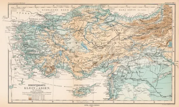
Justus Perthes, Asia Minor, 1875£ 145.00
-
Society for the Diffusion of Useful Knowledge (SDUK), West Africa I, 1875£ 175.00
-
Map Showing the Proposed Trade Routes from India & British Burmah to China, 1875Royal Geographical Society (RGS)Series: LondonRoyal Geographical Society (RGS), Map Showing the Proposed Trade Routes from India & British Burmah to China, 1875£ 395.00
-
George W. Bacon, Bristol, 1875 (c.)£ 185.00
-
H.H. Hardesty & Co., Map of California and Nevada, 1875 c.£ 275.00
-
Victor Clerot, Mappemonde Orographique et Hydrographique, 1875 c.£ 4,500.00
-
George W. Bacon, Greenwich, 1875 c.£ 395.00
-
The Environs of Edinburgh, 1875 c.Society for the Diffusion of Useful Knowledge (SDUK)Series: LondonSociety for the Diffusion of Useful Knowledge (SDUK), The Environs of Edinburgh, 1875 c.£ 175.00
-
Ferdinand Moritz Krause, Ararat Gold Field, 1876£ 495.00
-
Adrien Brue, Australasia and the Pacific Ocean, 1876£ 145.00
-
A. Simon, Dakar, Senegal, 1876£ 195.00
-
Justus Perthes, German Africa Expedition to Congo & Gabon, 1876£ 68.00
-
Royal Geographical Society (RGS), Lake Chad and Neighbouring Regions, 1876£ 68.00
-
Ernest Giles's expedition from Port Augusta to Perth, 1876Royal Geographical Society (RGS)Series: LondonRoyal Geographical Society (RGS), Ernest Giles's expedition from Port Augusta to Perth, 1876£ 585.00
-
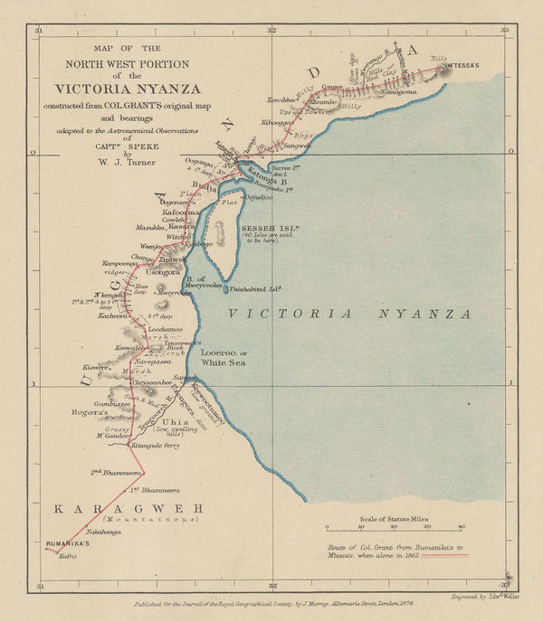
Royal Geographical Society (RGS), Lake Victoria and Uganda, 1876£ 110.00
-
Western Canada showing Canada-United States border, 1876Royal Geographical Society (RGS)Series: LondonRoyal Geographical Society (RGS), Western Canada showing Canada-United States border, 1876£ 375.00
-
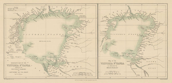
Lake Victoria according to Stanley, Speke & Grant, 1876Royal Geographical Society (RGS)Series: LondonRoyal Geographical Society (RGS), Lake Victoria according to Stanley, Speke & Grant, 1876£ 225.00
-
O.W. Gray & Son, New York, 1876£ 240.00
-
Royal Geographical Society (RGS), North-East Brazil, 1876£ 145.00
-
Thomas Richards, Mineral and Gold deposits, New South Wales, 1876£ 885.00
-
General Land Office (GLO), Territory of Utah, 1876£ 895.00
-
Justus Perthes, Ernest Giles's expeditions across Southern Australia, 1876£ 195.00
-
Lake Victoria according to Stanley, Speke & Grant, 1876Royal Geographical Society (RGS)Series: LondonRoyal Geographical Society (RGS), Lake Victoria according to Stanley, Speke & Grant, 1876£ 295.00
-
Justus Perthes, [Texasa and Indian Territory], 1876£ 385.00
-
A Map of The Northern Frontier of Khorassan with parts of Irak & Mazandaran, 1876Royal Geographical Society (RGS)Series: LondonRoyal Geographical Society (RGS), A Map of The Northern Frontier of Khorassan with parts of Irak & Mazandaran, 1876£ 445.00
-
Justus Perthes, Turkish Enclaves in the Balkans, 1876£ 195.00


![Justus Perthes, [Texasa and Indian Territory], 1876](https://static-assets.artlogic.net/w_600,c_limit,f_auto,fl_lossy,q_auto/artlogicstorage/themaphouse/images/view/488afc00723c4bf1a468f344f17d5a4dj/themaphouse-justus-perthes-texasa-and-indian-territory-1876.jpg)


Page
86
of 131