-
 Jean Jacques Élisée Reclus, Antwerp, 1894£ 48.00
 -
W. & A.K. Johnston, Myanmar (British Burma), Assam, and Manipur, 1894£ 115.00
-
Rajastan, Madhya Pradesh, Uttar Pradesh and Jharkhand, 1894W. & A.K. JohnstonSeries: Edinburgh & LondonW. & A.K. Johnston, Rajastan, Madhya Pradesh, Uttar Pradesh and Jharkhand, 1894£ 92.00
-
American Civil War, Coast of Texas and its Defences, 1894£ 495.00
-
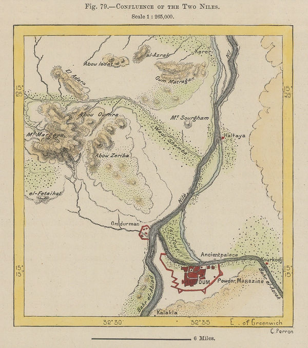
Jean Jacques Élisée Reclus, Confluence of the Two Niles, 1894£ 38.00
-
Benjamin Rees Davies, Davies' New Map of London and its Environs, 1894£ 1,950.00
-
Justus Perthes, Sakhalin, 1894£ 78.00
-
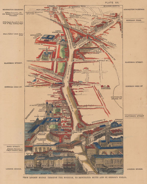
Thomas Sulman, Bird's-Eye View of London Bridge & Borough, 1894£ 115.00
-
Jean Jacques Élisée Reclus, Lucknow and its Environs, 1894£ 32.00
-
Map of Part of British and German East Africa including the British Protectorate of Uganda, 1894War OfficeSeries: LondonWar Office, Map of Part of British and German East Africa including the British Protectorate of Uganda, 1894£ 1,650.00
-
Map showing Mr Alldridge's Routes in the Hinterland of Sierra Leone, 1894Royal Geographical Society (RGS)Series: LondonRoyal Geographical Society (RGS), Map showing Mr Alldridge's Routes in the Hinterland of Sierra Leone, 1894£ 98.00
-
Littledale's journey from Lob Nor to Koko Nor, western China, 1894Royal Geographical Society (RGS)Series: LondonRoyal Geographical Society (RGS), Littledale's journey from Lob Nor to Koko Nor, western China, 1894£ 145.00
-
Royal Geographical Society (RGS), Montenegro, Albania and Novibazar, 1894£ 195.00
-
Scottish Geographical Society (SGS), Sketch Map of South Polar Regions, 1894£ 450.00
-
Sketch Maps Illustrating the Physical and Political Geography of Algeria, 1894Scottish Geographical Society (SGS)Series: EdinburghScottish Geographical Society (SGS), Sketch Maps Illustrating the Physical and Political Geography of Algeria, 1894£ 58.00
-
Sketch-Chart on Mercator's Projection, Showing Track of the 'Jason', 1893-94, 1894Scottish Geographical Society (SGS)Series: EdinburghScottish Geographical Society (SGS), Sketch-Chart on Mercator's Projection, Showing Track of the 'Jason', 1893-94, 1894£ 950.00
-
Edward Stanford, Barking, Royal Docks, Silvertown, Beckton & Thamesmead, 1894£ 175.00
-
Edward Stanford, Stanford's Map of the County of London - Sheet 17, 1894£ 925.00
-
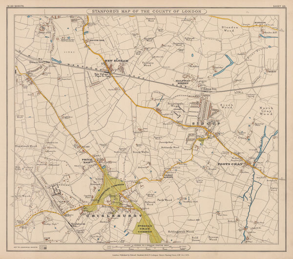
Edward Stanford, Eltham, Sidcup & Chislehurst, 1894£ 195.00
-
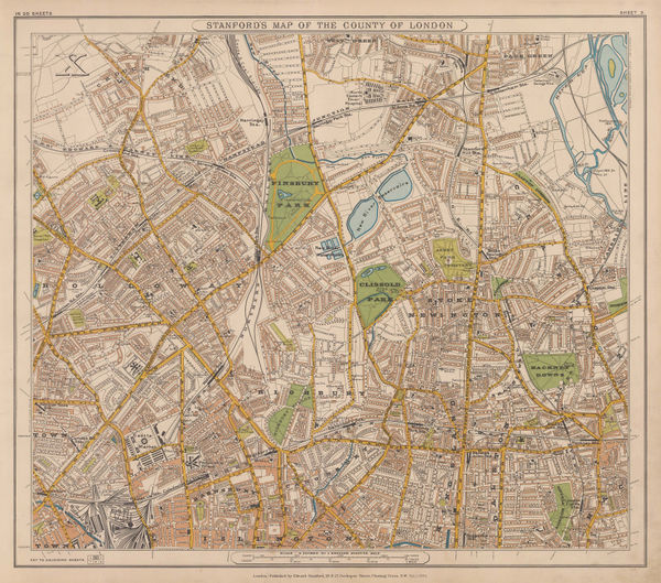
Edward Stanford, Stanford's Map of the County of London - Sheet 3, 1894£ 795.00
-
Edward Stanford, Stanford's Map of the County of London - Sheet 6, 1894£ 325.00
-
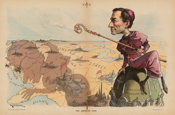
Keppler and Schwarzmann, The American Pope, 1894£ 1,900.00
-
Edward Stanford, Relief map of Istanbul (Constantinople) and the Bosphorus, 1894£ 195.00
-
Royal Geographical Society (RGS), Central and Northern Thailand, 1894£ 325.00
-
Edward Stanford, The Falkland Islands, Surveyed by Capt. Robert Fitz Roy, R. N., 1894£ 375.00
-
Jean Jacques Élisée Reclus, The Isle of Man, 1894£ 45.00
-
Scottish Geographical Society (SGS), The Mountain Systems of Central Asia, 1894£ 88.00
-
American Civil War, Southern Texas, 1894£ 245.00
-
Royal Geographical Society (RGS), Johore Territory and Singapore, 1894£ 795.00
-
-
William Bradley & Bro., Mexico, 1894£ 165.00
-
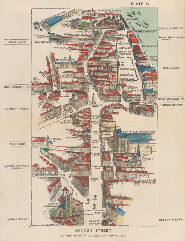
Thomas Sulman, Cannon Street, to the Mansion House, the Tower, etc, 1894£ 145.00
-
Royal Geographical Society (RGS), Tibet and the Surrounding Regions, 1894£ 795.00
-
Edward Stanford, Hampton Wick, Kingston, Norbiton & Petersham, 1894£ 475.00
-
Justus Perthes, Montenegro, 1894£ 145.00
-
Justus Perthes, Tokyo and Environs, 1894£ 95.00
-
Royal Geographical Society (RGS), Map of Iceland, 1894£ 195.00
-
Justus Perthes, The Island of Icaria, 1894£ 175.00
-
Albert Frederick Calvert, Australia Showing the Explorations, 1895£ 950.00
-
George W. Bacon, Berkshire, 1895£ 32.00
-
George W. Bacon, Dorsetshire, 1895£ 35.00
-
Justus Perthes, Wind map of the Pacific Ocean, 1895£ 38.00
-
Justus Perthes, Indian Ocean, 1895£ 38.00
-
Royal Geographical Society (RGS), Map of Mashonaland and Manika, 1895£ 445.00
-
Royal Geographical Society (RGS), Map of Part of East Africa, 1895£ 190.00
-
Scottish Geographical Society (SGS), Map of the Labrador Peninsula, 1895£ 325.00
-
George H. Walker & Co, Official Map of Boston, 1895£ 645.00
-
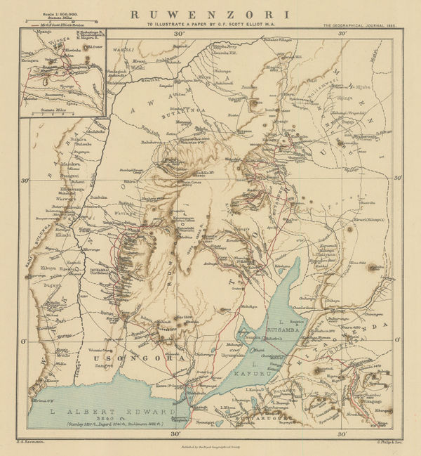
Royal Geographical Society (RGS), Rwenzori Mountains, Congo - Uganda border, 1895£ 185.00
-
British Admiralty, Sea Chart of the California Coast, 1895£ 750.00
-
British Admiralty, San Francisco Harbour, 1895£ 1,850.00
-
George W. Bacon, Staffordshire, 1895£ 35.00
-
Ordnance Survey, The Country around Faringdon, 1895£ 295.00
-
Ordnance Survey, The Country around High Wycombe, 1895£ 295.00
-
Ordnance Survey, The Country around Sandhurst, 1895£ 295.00
-
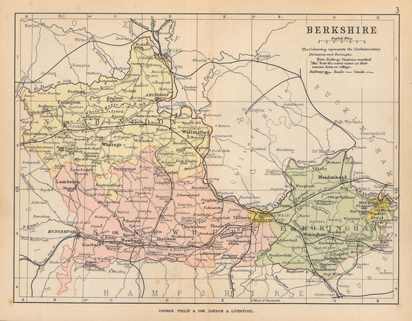
George Philip & Son Ltd., The County of Berkshire, 1895£ 22.00
-
George Philip & Son Ltd., The County of Dorset, 1895£ 35.00
-
George Philip & Son Ltd., The County of Wiltshire, 1895£ 20.00
-
Course of the Onilahy River, southwest Madagascar , 1895Royal Geographical Society (RGS)Series: LondonRoyal Geographical Society (RGS), Course of the Onilahy River, southwest Madagascar , 1895£ 125.00
-
Rand, McNally & Co., Washington, 1895£ 495.00
-
Justus Perthes, The West Indies and Gulf of Mexico, 1895£ 38.00
-
Ethelbert William Bullinger, XXVII. Perseus (The Breaker), 1895£ 85.00
-
Ethelbert William Bullinger, XXVII. Perseus (The Breaker), 1895£ 75.00
-
Anonymous, Tokyo, 1895£ 2,550.00
-
Ethelbert William Bullinger, VII. Lupus or Victima (The Victim), 1895£ 55.00
-
Ethelbert William Bullinger, XXXI. Auriga (The Shepherd), 1895£ 55.00
-
Ethelbert William Bullinger, IV. Bootes (The Coming One), 1895£ 75.00
-
Ethelbert William Bullinger, XXII. Andromeda (The Chained Woman), 1895£ 85.00
-
Ethelbert William Bullinger, XXXVI. Ursa Minor, 1895£ 65.00
-
Ethelbert William Bullinger, XXXIII. Lepus or Enemy (The Hare), 1895£ 55.00
-
Ethelbert William Bullinger, XIV. Ara (The Altar), 1895£ 55.00
-
XL. Hydra, Crater and Corvus (The Serpent, The Cup and The Raven), 1895Ethelbert William BullingerSeries: LondonEthelbert William Bullinger, XL. Hydra, Crater and Corvus (The Serpent, The Cup and The Raven), 1895£ 85.00
-
Ethelbert William Bullinger, XXIII Cepheus (The Crowned King), 1895£ 65.00
-
Justus Perthes, Kenya, Uganda and Tanzania, 1895£ 895.00
-
Ethelbert William Bullinger, XXXVII. Ursa Major, 1895£ 85.00
-
Ethelbert William Bullinger, XXVI. Cetus (The Sea Monster), 1895£ 75.00
-
George W. Bacon, Manchester, 1895£ 145.00
-
George W. Bacon, Sussex, 1895£ 75.00
-
George W. Bacon, The World on Mercator's Projection, 1895£ 225.00
-
George W. Bacon, Sheffield, 1895£ 145.00
-
George W. Bacon, Cheltenham, 1895£ 95.00


Page
100
of 131