-
 Karl Baedeker, New York, 1909£ 98.00
 -
Karl Baedeker, Philadelphia, 1909£ 85.00
-
J.G. Bartholomew, Bangladesh (East Bengal), Assam and Bhutan , 1909£ 88.00
-
J.G. Bartholomew, Rajasthan (Rajputana with Ajmer-Merwara), 1909£ 85.00
-
J.G. Bartholomew, Southern India - Andhra Pradesh., 1909£ 65.00
-
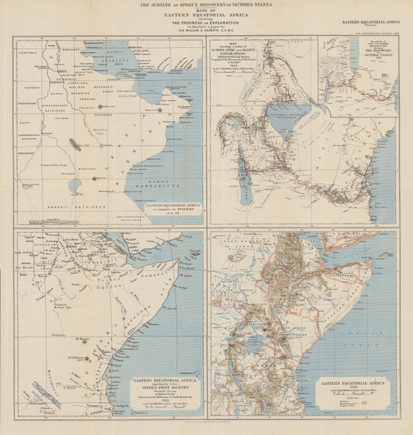
The Jubilee of Speke's Discovery of Victoria Nyanza, 1909Royal Geographical Society (RGS)Series: LondonRoyal Geographical Society (RGS), The Jubilee of Speke's Discovery of Victoria Nyanza, 1909£ 425.00
-
J.G. Bartholomew, Central India, 1909£ 65.00
-
J.G. Bartholomew, India - Density of Population, 1909£ 65.00
-
Karl Baedeker, Northern California, 1909£ 88.00
-
J.G. Bartholomew, Varanasi (Benares) and environs, 1909£ 75.00
-
Karl Baedeker, Vicinity of New York, 1909£ 58.00
-
J.G. Bartholomew, Environs of Kolkata (Calcutta), 1909£ 68.00
-
J.G. Bartholomew, India - Geological features, 1909£ 88.00
-
J.G. Bartholomew, West Bengal and Sikkim, 1909£ 75.00
-
Uttar Pradesh and Uttarakhand (The United Provinces of Agra and Oudh), 1909J.G. BartholomewSeries: EdinburghJ.G. Bartholomew, Uttar Pradesh and Uttarakhand (The United Provinces of Agra and Oudh), 1909£ 68.00
-
Karl Baedeker, Newport, Rhode Island, 1909£ 65.00
-
Karl Baedeker, Niagara Falls, 1909£ 55.00
-
Karl Baedeker, Los Angeles, 1909£ 125.00
-
Karl Baedeker, Chicago, 1909£ 78.00
-
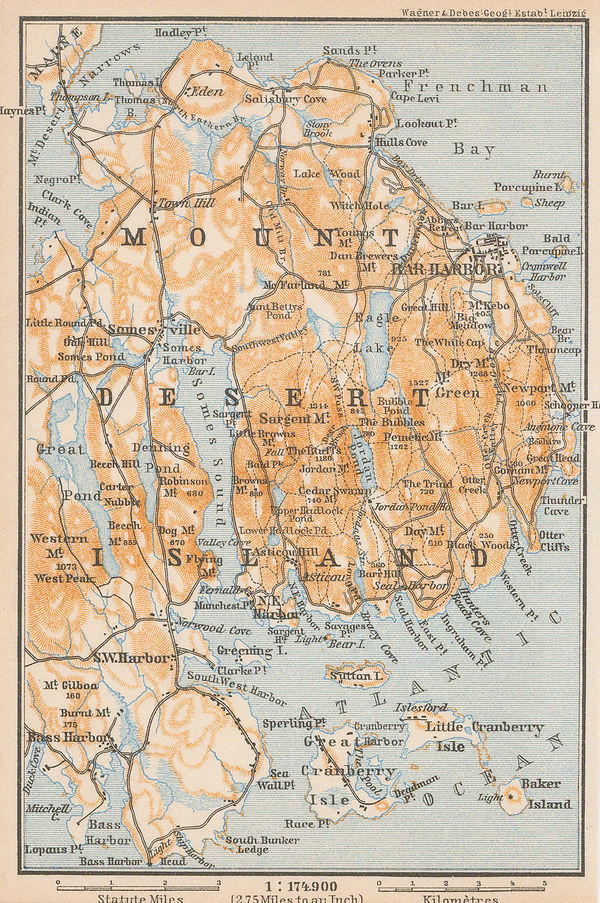
Karl Baedeker, Mount Desert Island, 1909£ 58.00
-
Karl Baedeker, Richmond, 1909£ 78.00
-
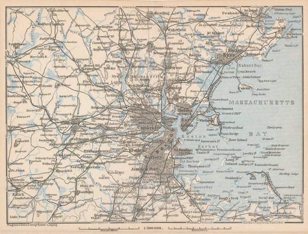
Karl Baedeker, Massachusetts Bay, 1909£ 58.00
-
Karl Baedeker, White Mountains and Franconia Mountains, 1909£ 58.00
-
Karl Baedeker, Brooklyn, 1909£ 98.00
-
Karl Baedeker, Buffalo, 1909£ 65.00
-
Karl Baedeker, Boston, 1909£ 88.00
-
Karl Baedeker, Detroit, 1909£ 75.00
-
Karl Baedeker, Pittsburgh and Allegheny, 1909£ 68.00
-
Karl Baedeker, The Grand Canyon, 1909£ 85.00
-
Karl Baedeker, Boston, 1909£ 115.00
-
John Bartholomew & Co., Railways of Northeast India & Bengal, 1909£ 125.00
-
John Bartholomew & Co., The Indian Empire and Surrounding Countries, 1909£ 95.00
-
John Bartholomew & Co., Principal Economic Minerals of India, 1909£ 95.00
-
John Bartholomew & Co., Railway Map of India, 1909£ 68.00
-
John Bartholomew & Co., Railways of South India & Sri Lanka, 1909£ 95.00
-
John Bartholomew & Co., Nepal & Part of Tibet, 1909£ 125.00
-
Chas. Baker & Co., London - A Bird's-Eye View, 1909£ 1,150.00
-
Karl Baedeker, San Francisco , 1909£ 195.00
-
John Bartholomew & Co., Afghanistan, 1909£ 95.00
-
John Bartholomew & Co., Northwest Pakistan & Kashmir, 1909£ 78.00
-
John Bartholomew & Co., Western India & Maharashtra, 1909£ 74.00
-
John Bartholomew & Co., Rangoon (Yangon), 1909£ 85.00
-
John Bartholomew & Co., Karachi, 1909£ 125.00
-
John Bartholomew & Co., Lahore, 1909£ 125.00
-
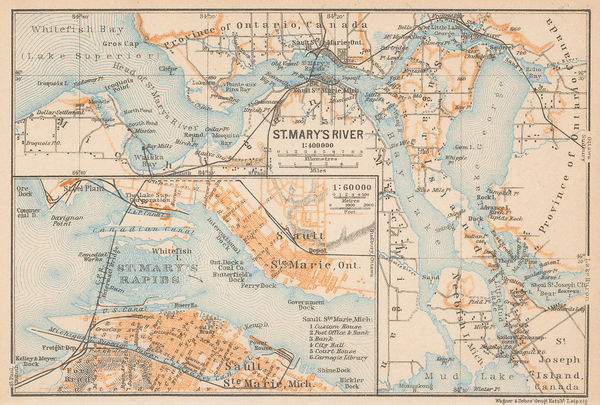
Karl Baedeker, Sault Ste. Marie, 1909£ 48.00
-
John Bartholomew & Co., City of Bombay (Mumbai), 1909£ 125.00
-
John Bartholomew & Co., Environs of Bombay (Mumbai), 1909£ 95.00
-
Karl Baedeker, Mexico City, 1909£ 68.00
-
Justus Perthes, The Stars of the Northern Hemisphere, 1909£ 115.00
-
Karl Baedeker, Havana, 1909£ 68.00
-
Justus Perthes, The Stars of the Southern Hemisphere, 1909£ 115.00
-
Karl Baedeker, [British Columbia and Vancouver Island], 1909£ 68.00
-
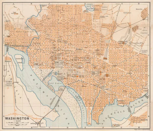
Karl Baedeker, Washington, 1909£ 185.00
-
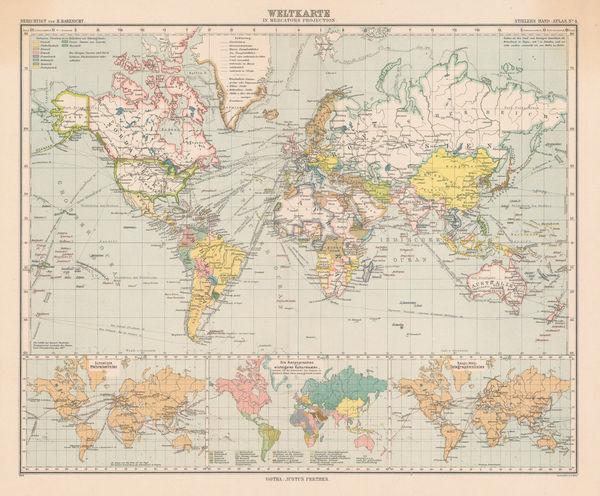
Justus Perthes, The World on Mercator's Projection, 1909£ 175.00
-
Karl Baedeker, St. Augustine, 1909£ 86.00
-
Karl Baedeker, Denver, 1909£ 86.00
-
Adolf Stieler, The North Pole, 1909£ 225.00
-
British Antarctic Expedition 1907, Routes and Surveys of the Southern Journey Party 1908- 09, 1909 c.William HeinemannSeries: LondonWilliam Heinemann, British Antarctic Expedition 1907, Routes and Surveys of the Southern Journey Party 1908- 09, 1909 c.£ 3,500.00
-
Karl Baedeker, Northern Florida, 1909 c.£ 55.00
-
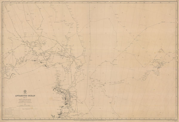
British Admiralty, Antarctic Ocean Sheet IV, 1910£ 3,500.00
-
Royal Geographical Society (RGS), Lake Chad, 1910£ 155.00
-
R.S. Templeton, Sri Lanka (Ceylon), 1910£ 850.00
-
Royal Geographical Society (RGS), Zambia & the Congo, 1910£ 175.00
-
R.C. McPhillips, Map of the City of Winnipeg, 1910£ 895.00
-
'The Motor' Magazine, Map of the West End of London, 1910£ 495.00
-
Agricultural lands, gold fields and rainfall distribution, 1910Royal Geographical Society (RGS)Series: LondonRoyal Geographical Society (RGS), Agricultural lands, gold fields and rainfall distribution, 1910£ 325.00
-
Royal Geographical Society (RGS), Kurdistan Region, Iraq, 1910£ 225.00
-
Royal Geographical Society (RGS), Sketch Map of North West Arabia, 1910£ 425.00
-
Royal Geographical Society (RGS), South West Africa, 1910£ 285.00
-
Royal Geographical Society (RGS), The Tigris Euphrates Delta, 1910£ 195.00
-
Old Mill Cigarettes, [New Mexico], 1910£ 75.00
-
E. P. Noll & Co., New Official Guide Map of Philadelphia, 1910£ 675.00
-
Nestor Larras, French Army Map of Casablanca and Environs, 1910£ 395.00
-
Royal Geographical Society (RGS), Peary's North Pole Expedition (1908-1909), 1910£ 325.00
-
W.H. & L. Collingridge, Plan of the City of London, 1910£ 495.00
-
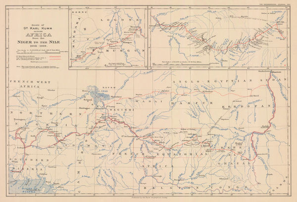
Dr. Karl Kumm's route from the Niger to the Nile, 1910Royal Geographical Society (RGS)Series: LondonRoyal Geographical Society (RGS), Dr. Karl Kumm's route from the Niger to the Nile, 1910£ 285.00
-
I. P. Berthrong, Territory of Arizona, 1910£ 525.00
-
W. Thacker & Co., Reduced Survey Map of India, 1910£ 885.00
-
O.P. Anderson, Map of Puget Sound Country, 1910£ 2,750.00
-
George W. Bacon, North & Northwest London, 1910 (c.)£ 850.00


![Karl Baedeker, [British Columbia and Vancouver Island], 1909](https://static-assets.artlogic.net/w_600,c_limit,f_auto,fl_lossy,q_auto/artlogicstorage/themaphouse/images/view/99a3db3157adb371c8d7608b0b8487ccj/themaphouse-karl-baedeker-british-columbia-and-vancouver-island-1909.jpg)


![Old Mill Cigarettes, [New Mexico], 1910](https://static-assets.artlogic.net/w_600,c_limit,f_auto,fl_lossy,q_auto/artlogicstorage/themaphouse/images/view/9182d82c7c077ee10aef250e19d3016bj/themaphouse-old-mill-cigarettes-new-mexico-1910.jpg)


Page
108
of 131