-
 Railway Clearing House, Official Railway Map of London and its Environs, 1907£ 550.00
 -
Royal Geographical Society (RGS), Coast of Mozambique, 1907£ 78.00
-
Royal Geographical Society (RGS), Victoria Nyanza to Mt. Kilimanjaro, 1907£ 445.00
-
Rand McNally, Kentucky, 1907£ 395.00
-
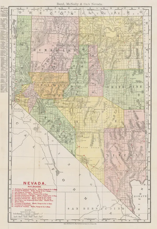
Rand, McNally & Co., New Commercial Atlas Map of Nevada, 1907£ 195.00
-
Edward Stanford, Ionian Islands, 1907£ 55.00
-
Edward Stanford, Valetta, Malta, 1907£ 55.00
-
-
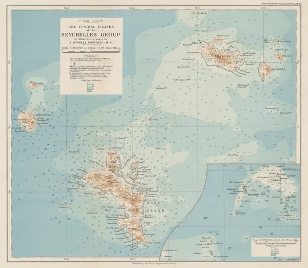
Royal Geographical Society (RGS), The Central Islands of the Seychelles Group, 1907£ 425.00
-
Rand, McNally & Co., West Virginia, 1907£ 175.00
-
A. & C. Black, St James Park & Green Park, 1907£ 75.00
-
A. & C. Black, Regents Park, 1907£ 75.00
-
A. & C. Black, Central London, 1907£ 75.00
-
George W. Bacon, Map of the Golf Courses around London, 1907 c.£ 1,350.00
-
G. Exsteen, Brussels (Bruxelles), 1907 c.£ 145.00
-
George W. Bacon, New Chart of the World, 1907 c.£ 2,950.00
-
James White, Northern Quebec, Labrador, and Hudson Bay, 1908£ 295.00
-
Karl Baedeker, Cadiz, 1908£ 46.00
-
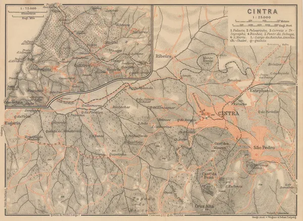
Karl Baedeker, Sintra, 1908£ 42.00
-
-
Karl Baedeker, Genoa / Genova, 1908£ 80.00
-
Ordnance Survey, Geological Map of Oxford & Environs, 1908£ 175.00
-
-
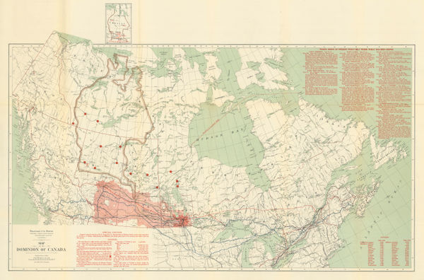
James White, Wheat growing areas of Canada, 1908£ 325.00
-
Royal Geographical Society (RGS), Nanda Devi National Park, Himalayas, 1908£ 295.00
-
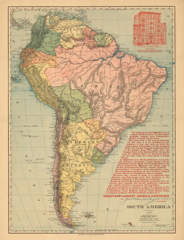
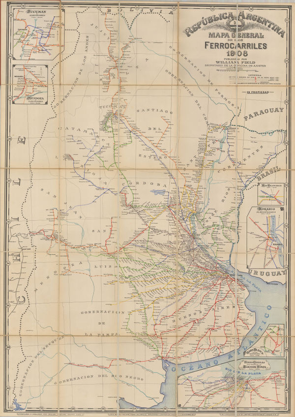
William Field, Railway map of Argentina, 1908£ 4,750.00
-
Royal Geographical Society (RGS), Mackenzie Delta, Northwest Territories, 1908£ 425.00
-
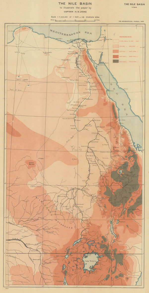
Royal Geographical Society (RGS), Orographical map of the Nile Basin, 1908£ 195.00
-
-
W. & A.K. Johnston, United States (S.E.), 1908£ 125.00
-
Richard Holmes Laurie, Honolulu Harbour, 1908£ 145.00
-
Richard Holmes Laurie, Inland Sea of Japan (Setouchi), 1908£ 72.00
-
John Bartholomew, Edinburgh, 1908£ 95.00
-
Royal Geographical Society (RGS), Sketch Map of Jamaica, 1908£ 275.00
-
Edward Stanford, Stanford's Portable Map of India, 1908 (c.)£ 995.00
-
-
Edward Hertslet, Map of the Frontier between British East Africa and Abyssinia, 1909£ 225.00
-
Edward Hertslet, Anglo-Portuguese Boundary in Manica and Adjoining Regions, 1909£ 82.00
-
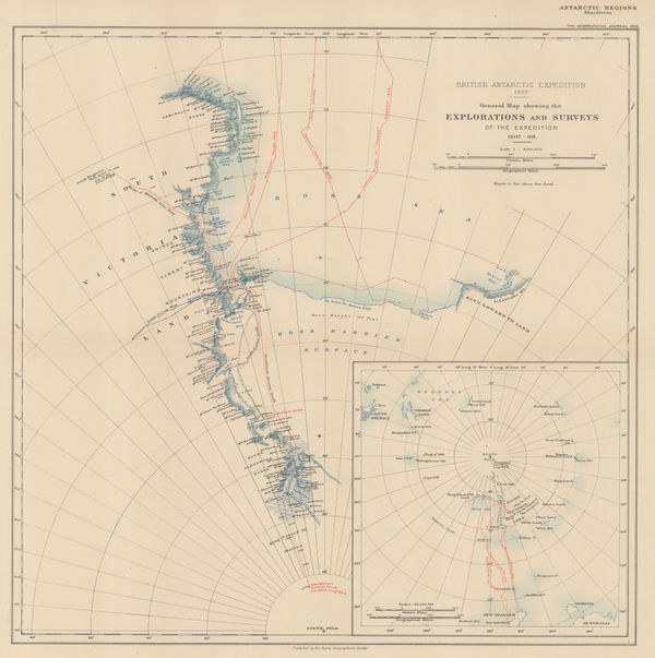
British Antarctic Expedition 1907. Route and Surveys of the South Magnetic Polar Party, 1909William HeinemannSeries: LondonWilliam Heinemann, British Antarctic Expedition 1907. Route and Surveys of the South Magnetic Polar Party, 1909£ 3,000.00
-
Edward Hertslet, Resolving Cameroon's Eastern Border, 1909£ 145.00
-
Royal Geographical Society (RGS), Uganda - Congo Border Commission, 1909£ 325.00
-
Karl Baedeker, Cincinnati, 1909£ 44.00
-
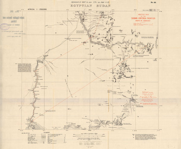
Edward Hertslet, Egyptian Sudan, 1909£ 145.00
-
Royal Geographical Society (RGS), Shackleton's British Antarctic Expedition, 1909£ 2,200.00
-
Edward Hertslet, Cameroon - Equatorial Guinea Border Commission, 1909£ 44.00
-
Karl Baedeker, Indianapolis, 1909£ 44.00
-
-
Map of the Anglo-French Boundary from the Gulf of Guinea to the Niger, 1909Edward HertsletSeries: SouthamptonEdward Hertslet, Map of the Anglo-French Boundary from the Gulf of Guinea to the Niger, 1909£ 175.00
-
Map of the Anglo-French Boundary from the Gulf of Guinea to the Niger (Southern Portion), 1909Edward HertsletSeries: LondonEdward Hertslet, Map of the Anglo-French Boundary from the Gulf of Guinea to the Niger (Southern Portion), 1909£ 125.00
-
Map of the Frontier between Gold Coast and Togoland by the Boundary Commission, 1909Edward HertsletSeries: LondonEdward Hertslet, Map of the Frontier between Gold Coast and Togoland by the Boundary Commission, 1909£ 145.00
-
-
Edward Hertslet, Map of the Sierra Leone-Liberia Boundary, 1909£ 115.00
-
Edward Hertslet, Map Shewing the Position of The District of Tati, 1909£ 32.00
-
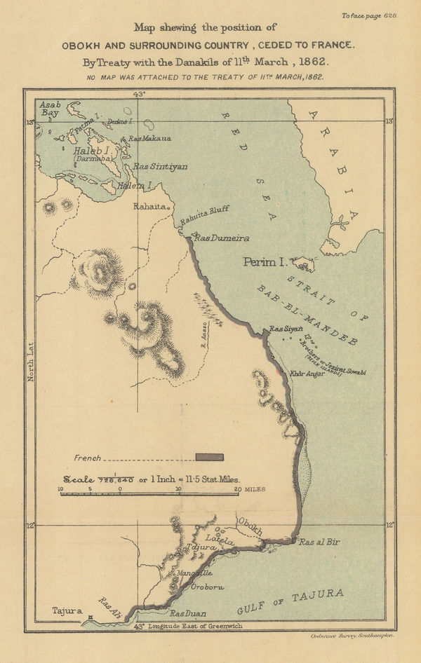
Map Showing the Position of Obokh and Surrounding Country, Ceded to France, 1909Edward HertsletSeries: SouthamptonEdward Hertslet, Map Showing the Position of Obokh and Surrounding Country, Ceded to France, 1909£ 32.00
-
Edward Hertslet, Map Showing Turco-Egyptian Boundary, 1909£ 62.00
-
Edward Hertslet, Resolving Cameroon's Borders, 1909£ 58.00
-
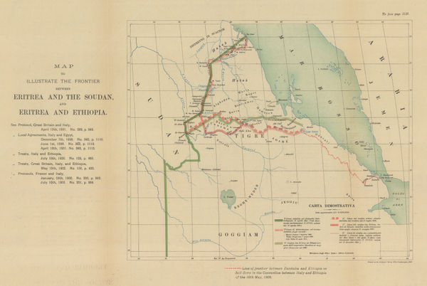
Edward Hertslet, Sudan and Ethiopia, 1909£ 65.00
-
Karl Baedeker, Minneapolis, 1909£ 52.00
-
Karl Baedeker, New Haven, 1909£ 42.00
-
Edward Hertslet, Nigeria - Cameroon Boundary Commission, 1909£ 115.00
-
Edward Hertslet, Nigeria - Cameroon Boundary Commission, 1909£ 40.00
-
Edward Hertslet, Nyasa-Tanganyika Boundary, 1909£ 85.00
-
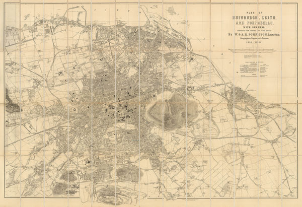
W. & A.K. Johnston, Plan of Edinburgh, Leith and Portobello with Suburbs, 1909£ 845.00
-
Edward Hertslet, Western Sahara and Mauritania border, 1909£ 48.00
-
Sketch map of the overland route from Baghdad to Damascus, 1909Royal Geographical Society (RGS)Series: LondonRoyal Geographical Society (RGS), Sketch map of the overland route from Baghdad to Damascus, 1909£ 295.00
-
Routes and Surveys of the South Magnetic Polar Party, 1909Royal Geographical Society (RGS)Series: LondonRoyal Geographical Society (RGS), Routes and Surveys of the South Magnetic Polar Party, 1909£ 1,650.00
-
Karl Baedeker, Salt Lake City, 1909£ 42.00
-
Edward Hertslet, Sierra Leone - Liberia Boundary, 1909£ 85.00
-
Sketch Map of Ordos to illustrate a paper by W. R. Carles. C. M. G., 1909Royal Geographical Society (RGS)Series: LondonRoyal Geographical Society (RGS), Sketch Map of Ordos to illustrate a paper by W. R. Carles. C. M. G., 1909£ 185.00
-
Royal Geographical Society (RGS), Sketch Map of Tibet, 1909£ 325.00
-
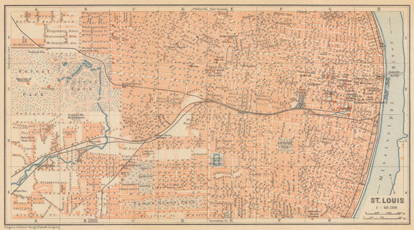
Karl Baedeker, St. Louis, 1909£ 72.00
-
Karl Baedeker, St. Paul, 1909£ 38.00
-
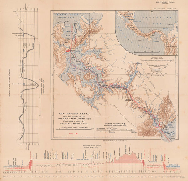
Royal Geographical Society (RGS), The Panama Canal, 1909£ 295.00
-
Rand, McNally & Co., The Soash Special, 1909£ 1,850.00
-
Karl Baedeker, Colorado Springs - Pike's Peak, 1909£ 58.00
-
Karl Baedeker, Cuba, Jamaica & Puerto Rico, 1909£ 45.00
-
Karl Baedeker, Grand Canyon, 1909£ 52.00
-
Karl Baedeker, Wyoming, 1909£ 48.00
-
Karl Baedeker, Cambridge & Harvard, 1909£ 88.00
-
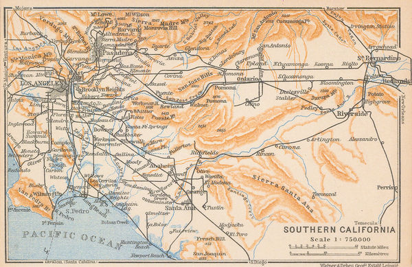
Karl Baedeker, Southern California, 1909£ 68.00


Page
107
of 131