-
 A. de Boeck, Brussels (Bruxelles), 1935£ 350.00
 -
Vicente Martorell Portas, Folding wall map of Barcelona, 1935£ 850.00
-
Terry's Guide, Plan of Victoria de Durango, 1935£ 42.00
-
Terry's Guide, Plan of Guadalajara, 1935£ 48.00
-
Terry's Guide, Plan of Zacatecas, 1935£ 38.00
-
Anonymous, The British Empire in the Jubilee Year of King George V, 1935£ 500.00
-
Ernest Dudley Chase, The United States of America, 1935£ 1,450.00
-
Zev Vilnay, Haifa and Mt. Carmel, 1935£ 95.00
-
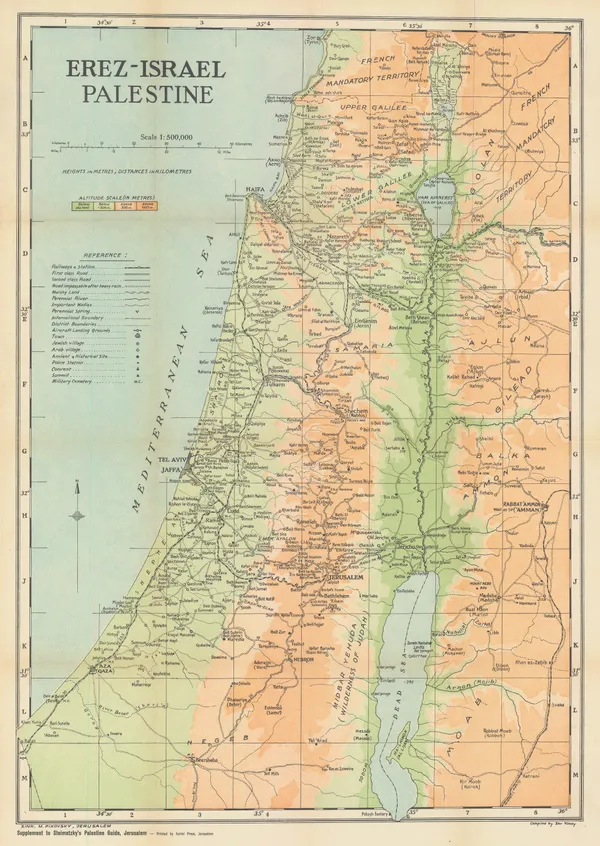
Zev Vilnay, Israel, 1935£ 295.00
-
William Harding Thompson, Sussex, 1935£ 145.00
-
Royal Geographical Society (RGS), Egypt, Libya, and Sudan Boundary Map, 1935£ 58.00
-
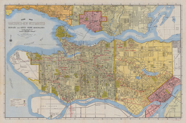
Grant & Sons, City of Vancouver, 1935£ 675.00
-
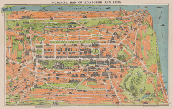
George Reid, Pictorial Map of Edinburgh and Leith, 1935£ 325.00
-
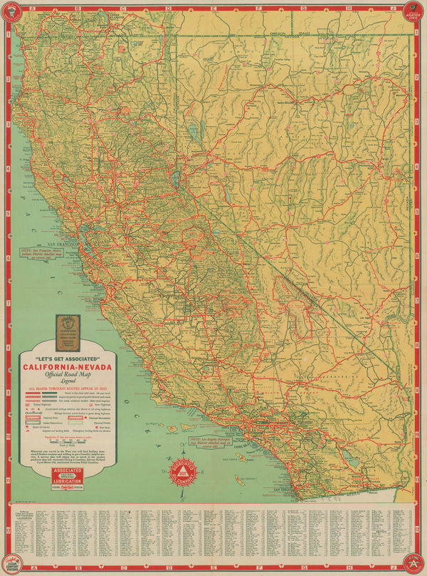
Schwabacher-Frey, California & Nevada, 1935£ 195.00
-
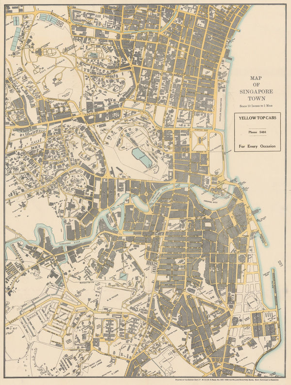
A.C. Willis, Map of Singapore Town, 1935£ 2,000.00
-
B. Rosenthal, Plan of Warsaw, 1935£ 485.00
-
John Bartholomew & Son, Rome, 1935£ 125.00
-
Clifford & Rosemary Ellis, Christmas Shopping by Underground Poster, 1935£ 4,000.00
-
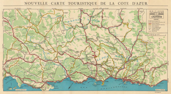
L'Eclaireur, Tourist Map of the Cote d'Azur, 1935 (c.)£ 175.00
-
Mississippi Coast Hotel Association, The Gulf Coast of Mississippi, 1935 (c.)£ 180.00
-
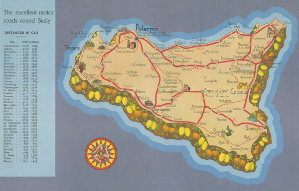
Off. Tipo-Litografiche IRES, Sicily - The Gem of the Mediterranean, 1935 (c.)£ 95.00
-
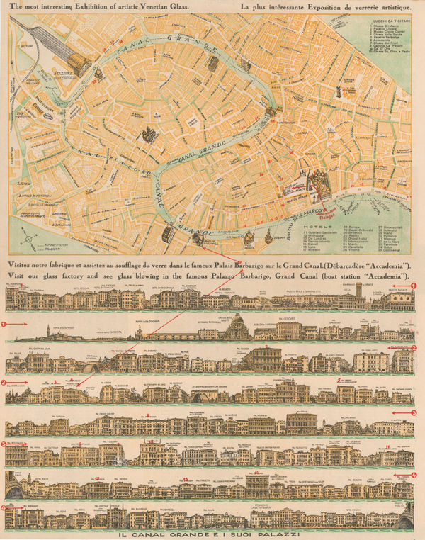
Compagnia Venezia Murano, Venice and its Palaces, 1935 (c.)£ 295.00
-
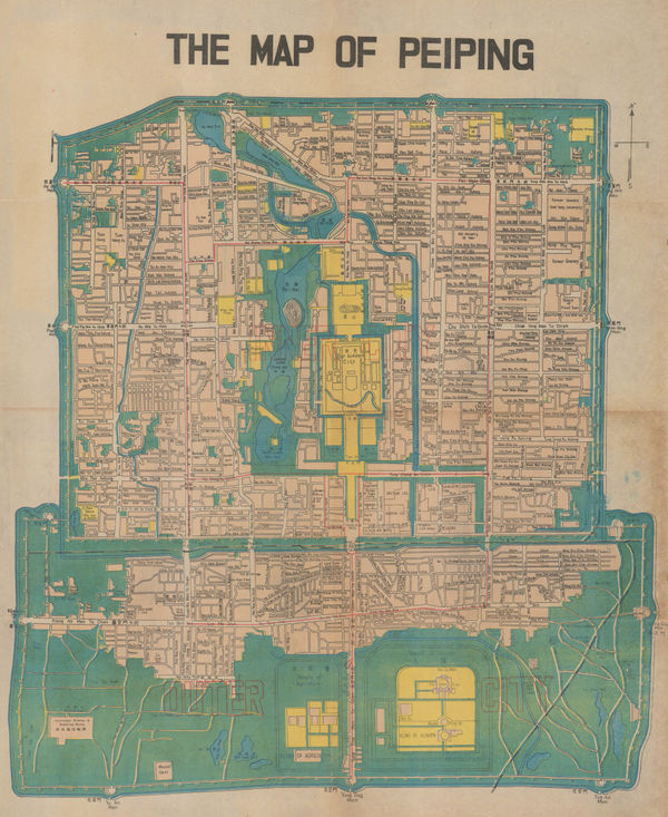
Anonymous, Beijing, 1935 c£ 1,450.00
-
Malmö Kartografiska Anstalt, French Riviera from Nice to Menton, 1935 c£ 55.00
-
Malmö Kartografiska Anstalt, Central Venice, 1935 c£ 55.00
-
Malmö Kartografiska Anstalt, Venice, 1935 c£ 65.00
-
California State Automobile Association, California, 1935 c£ 750.00
-
Dept. of Lands, Map of the City of Sydney, 1935 c£ 925.00
-
Alexander Gross, Central Asia, 1935 c.£ 295.00
-
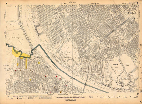
Ordnance Survey, Fulham, 1935 c.£ 1,250.00
-
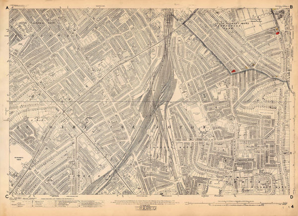
Ordnance Survey, Highbury, 1935 c.£ 795.00
-
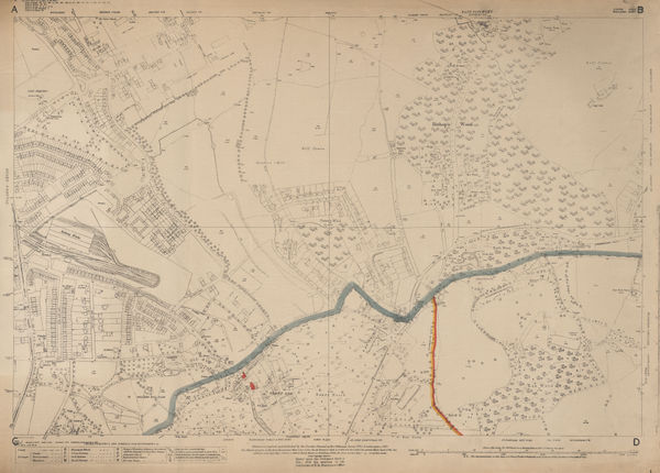
Ordnance Survey, North Hampstead, 1935 c.£ 425.00
-
Ordnance Survey, Queens Park and Kensal Town, 1935 c.£ 625.00
-
Ordnance Survey, Regents Park, 1935 c.£ 845.00
-
Ordnance Survey, Regents Park to Kings Cross, 1935 c.£ 845.00
-
Royal Geographical Society (RGS), South Shetland Islands, 1935 c.£ 195.00
-
Feller Frères, Plan Monumental de la Ville de Luxembourg, 1935 c.£ 325.00
-
Geographia Ltd., 10 inch Terrestrial Globe, 1935 c.£ 2,750.00
-
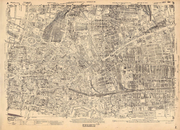
Ordnance Survey, Knightsbridge and Kensington, 1936£ 1,550.00
-
Aden Protectorate: Route traverse through the Hadhramaut from Mukalla to Seihut, 1934, 1936Royal Geographical Society (RGS)Series: LondonRoyal Geographical Society (RGS), Aden Protectorate: Route traverse through the Hadhramaut from Mukalla to Seihut, 1934, 1936£ 245.00
-
Rudolf Seeland, Berlin, 1936£ 165.00
-
Buohl's Illustrated Map and Guide to Tour The Gettysburg Battlefield, 1936George W. BuohlSeries: Gettysburg, PAGeorge W. Buohl, Buohl's Illustrated Map and Guide to Tour The Gettysburg Battlefield, 1936£ 250.00
-
Lith. Ypiranga, Rio de Janeiro, 1936£ 950.00
-
Edward Stanford, Chart of the Thames Estuary, 1936£ 345.00
-
Kingu Magazine (キング), Pre-WW2 Japanese Map of Europe, 1936£ 950.00
-
Port of London Authority, Royal Docks Development Plan, 1936£ 1,650.00
-
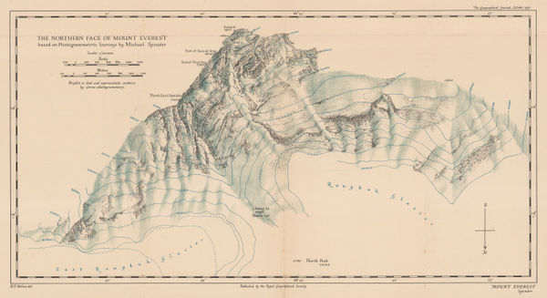
Royal Geographical Society (RGS), The Northern Face of Mount Everest, 1936£ 675.00
-
-
Municipal Information Office, Budapest, 1936£ 395.00
-
-
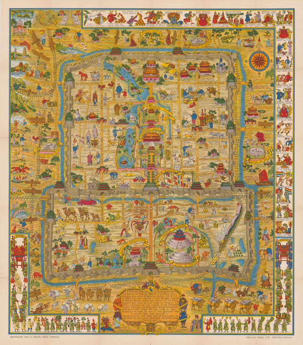
Frank Dorn, Beijing, 1936£ 2,850.00
-
Fusazo Sugie, The New Map of Shanghai, 1936£ 3,500.00
-
Charles Owens, California Official Tourist Picture Map, 1936£ 495.00
-
Imperial Airways, Map of the Empire and European Air Routes, 1936£ 3,000 (framed)
-
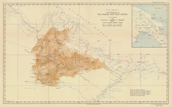
Headwaters of the Purari and Yuat Rivers, Papua New Guinea, 1936Royal Geographical Society (RGS)Series: LondonRoyal Geographical Society (RGS), Headwaters of the Purari and Yuat Rivers, Papua New Guinea, 1936£ 175.00
-
-
A Sketch Map Itinerarium of Part of North Western Arabia and Negd, 1936Charles Montagu DoughtySeries: LondonCharles Montagu Doughty, A Sketch Map Itinerarium of Part of North Western Arabia and Negd, 1936£ 950.00
-
George Philip & Son Ltd., 8-Inch Philips' British Empire Globe, 1936 (c.)£ 950.00
-
Ordnance Survey, Battersea, 1936 c.£ 1,450.00
-
Ordnance Survey, Bayswater, 1936 c.£ 1,450.00
-
Ordnance Survey, Belsize Park and Swiss Cottage, 1936 c.£ 925.00
-
Ordnance Survey, Chiswick, 1936 c.£ 695.00
-
Ordnance Survey, Fulham, 1936 c.£ 1,350.00
-
Ordnance Survey, Parliament Hill Fields and Tufnell Park, 1936 c.£ 950.00
-
Ordnance Survey, The City of London, Aldgate & Bishopsgate, 1936 c.£ 1,250.00
-
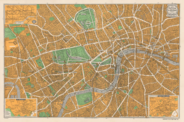
Geographia Ltd., Pictorial Map of London, 1936 c.£ 395.00
-
MacDonald Gill, A Great Industry - Where Our Tea Comes From, 1937£ 4,950.00
-
A Slightly Cockeyed map of that slightly Cockeyed Community Hollywood, 1937John GrothSeries: Los AngelesJohn Groth, A Slightly Cockeyed map of that slightly Cockeyed Community Hollywood, 1937£ 950.00
-
British Admiralty, Arabian Sea, 1937£ 1,565.00
-
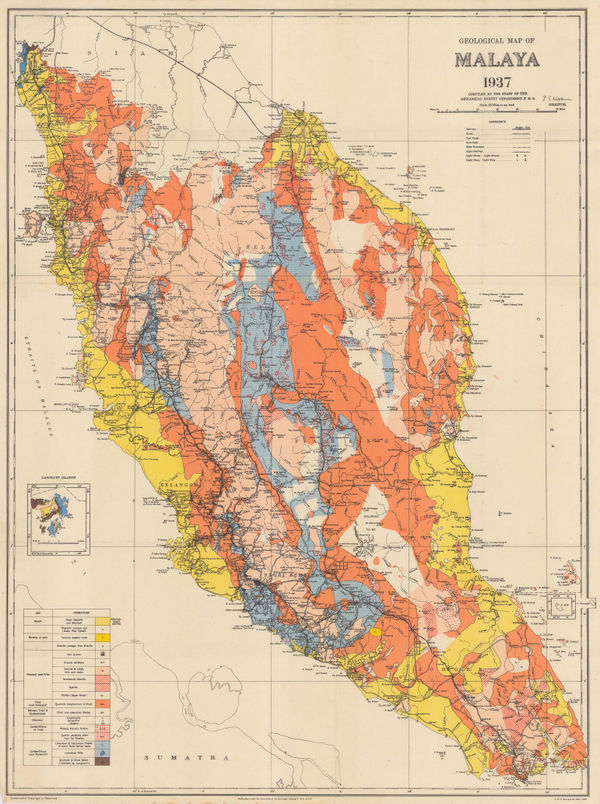
Fed. Malay States, Geological map of the Malay Peninsula, 1937£ 695.00
-
French State Railway, Paris Welcomes You, 1937£ 2,000.00
-
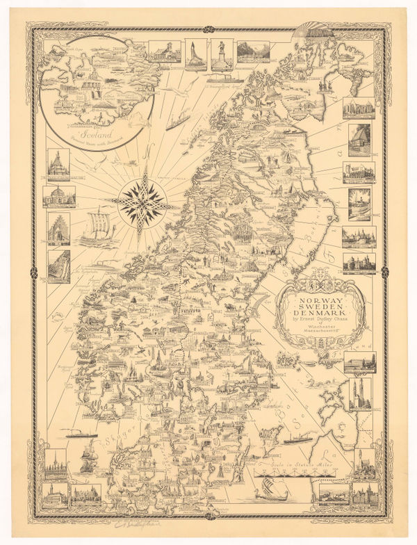
Ernest Dudley Chase, Norway, Sweden, and Denmark, 1937£ 1,250.00
-
Roto-Sadag, Geneva, 1937£ 175.00
-
Camille Rodier, Wine map of Cote de Beaune and Cote de Nuits, Burgundy, 1937£ 125.00
-
J. Loeb, Spanish Civil War News Map, 1937£ 950.00
-
London Transport, Underground Railway Map, 1937£ 450.00
-
RHS Calendar of Shows & Application for Fellowship, 1937Royal Horticultural Society (RHS)Series: LondonRoyal Horticultural Society (RHS), RHS Calendar of Shows & Application for Fellowship, 1937£ 200.00
-
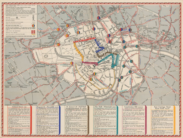
Geographia Ltd., The Coronation Area, 1937£ 450 (framed)
-
Camille Rodier, Wine map of Cote de Beaune and Cotes de Nuits, Burgundy, 1937£ 750.00
-
Parker Edwards, Hawaiian Islands, 1937£ 850.00


Page
119
of 131