-
 British Admiralty, Bassein River to Pulo Penang, 1932£ 1,550.00
 -
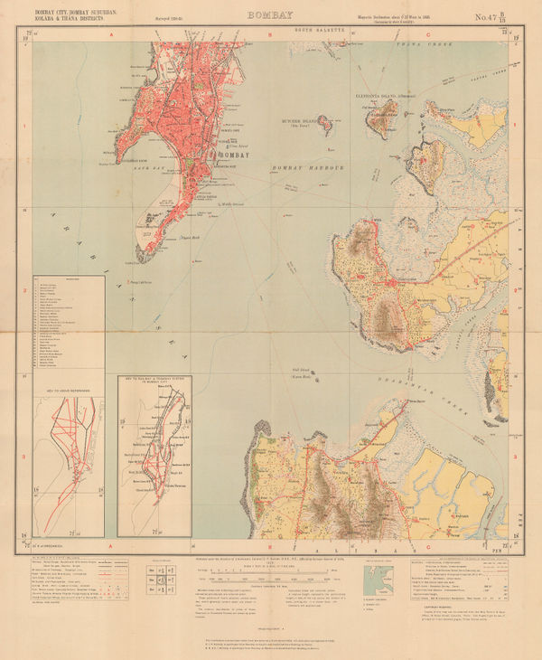
Survey of India, Mumbai (Bombay), 1932£ 950.00
-
Service Géographique de l'Armée, Vintage map of Western Morocco, 1932£ 325.00
-
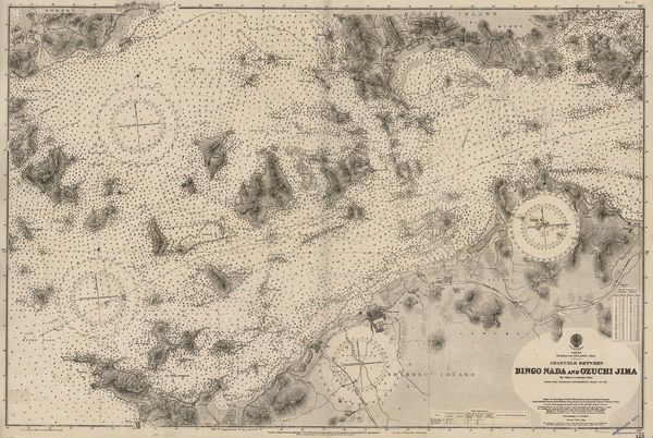
British Admiralty, Channels between Bingo Naga and Ozuchi Jima., 1932£ 495.00
-
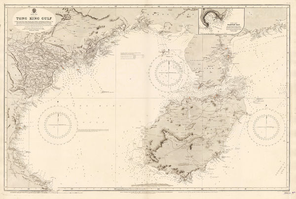
British Admiralty, Gulf of Siam, 1932£ 2,850.00
-
-
Dutch Topographical Service, Vintage map of Eastern Java and Bali, 1932£ 925.00
-
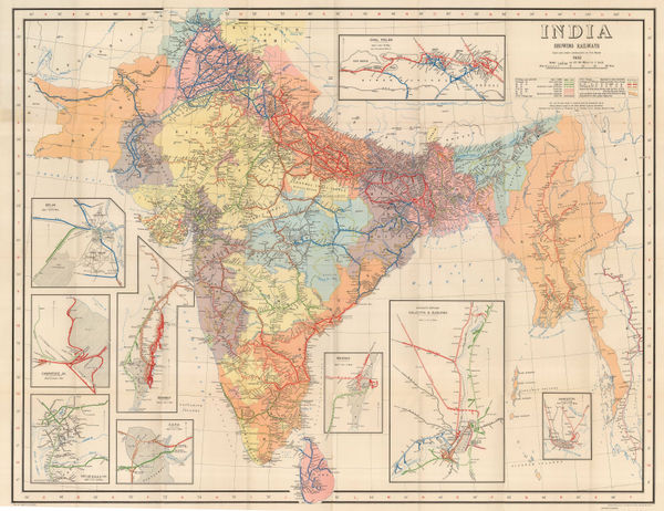
Survey of India, India Showing Railways, 1932£ 475.00
-
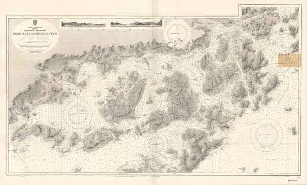
British Admiralty, Japan Inland Sea. Channels between Neko Seto & Mekari Seto, 1932£ 625.00
-
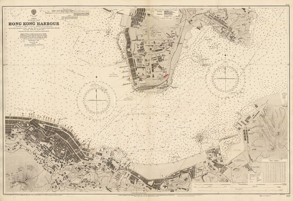
British Admiralty, Kiaochow Bay, 1932£ 1,850.00
-
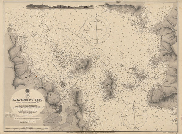
British Admiralty, Kurusima No Seto (Kaikyo), 1932£ 295.00
-
André Galland, French Anti-Disarmament Propaganda, 1932£ 1,800.00
-
Intourist, Pictorial map of St. Petersburg (Leningrad), 1932£ 145.00
-
Edward Stanford, Hyde Park Corner Tube Station and 1/4 Miles Around, 1932£ 1,250.00
-
Dept. of Lands, Sydney and South eastern New South Wales, 1932£ 425.00
-
British Admiralty, Ockseu Is. to Tung Yung, 1932£ 885.00
-
Almacenes Alemanes, Barcelona, 1932£ 545.00
-
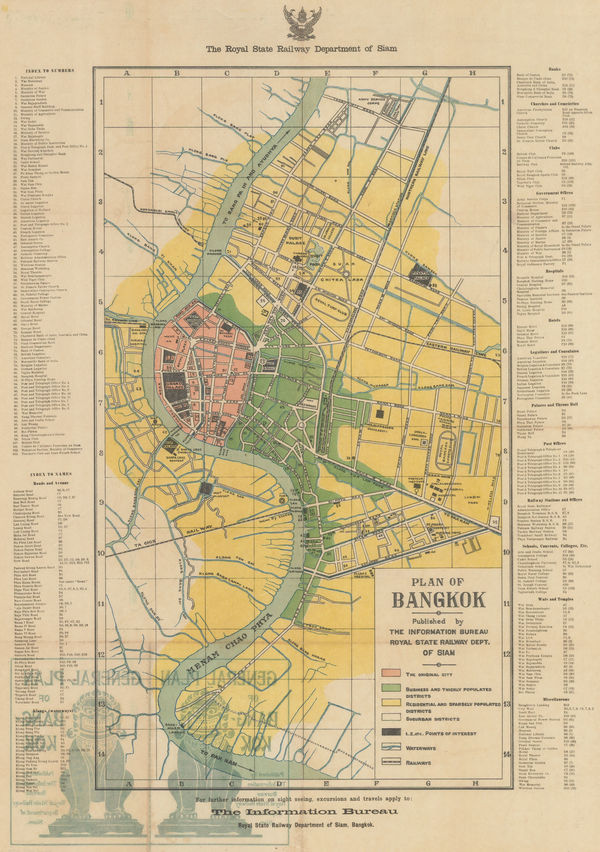
Siam Railways, Bangkok, 1932£ 895.00
-
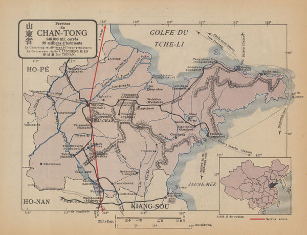
René Jouon, Province du Chiang-Tong, 1932£ 95.00
-
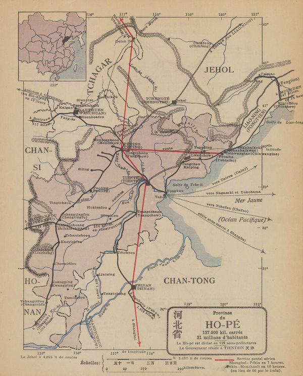
René Jouon, Provine du Ho-Pe, 1932£ 85.00
-
British Admiralty, Southern Approach to the Yangtze Kiang, 1932£ 1,450.00
-
Surveys and Soundings of the R.R.S. Discovery II, 1932Royal Geographical Society (RGS)Series: LondonRoyal Geographical Society (RGS), Surveys and Soundings of the R.R.S. Discovery II, 1932£ 280.00
-
British Admiralty, Tien Pak to Macao, 1932£ 1,550.00
-
British Admiralty, Tung Yung to Wen Chau Bay, 1932£ 885.00
-
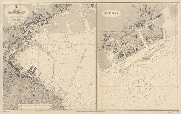
British Admiralty, YokoHama-Ko, 1932£ 725.00
-
C. Y. Soo, Map showing Japanese-Chinese Warfare now in Shanghai, 1932£ 1,250.00
-
Feliks Kasprzykiewicz, Warsaw, 1932£ 325.00
-
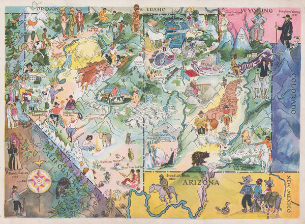
Elmer & Berta Hader, Colorado and Wyoming, 1932£ 95.00
-
Elmer & Berta Hader, Nevada and Utah, 1932£ 85.00
-
Elmer & Berta Hader, Kansas and Nebraska, 1932£ 85.00
-
Elmer & Berta Hader, Kentucky and Tennessee, 1932£ 95.00
-
M. Munier, Vintage city plan of Dijon, 1932£ 250.00
-
London Transport, London Tramways, 1932£ 150.00
-
-
John Murray, Prayagraj (Allahabad), 1933£ 38.00
-
John Murray, Vijayapura (Bijarpur), 1933£ 28.00
-
John Murray, Kanpur (Cawnpore), 1933£ 45.00
-
John Murray, Darjeeling, 1933£ 24.00
-
-
John Murray, Nagpur, 1933£ 48.00
-
-
Sifton Praed & Co., Naval Bases of The Great Powers, 1933£ 725.00
-
Royal Geographical Society (RGS), Rwenzori Mountains, 1933£ 225.00
-
John Bartholomew, Tunis, 1933£ 55.00
-
Royal Geographical Society (RGS), South Haven Peninsula : Studland Heath, 1933£ 225.00
-
Japanese Railways, Mount Fuji (Fuji-san), 1933£ 62.00
-
Malmö Kartografiska Anstalt, Copenhagen, 1933£ 58.00
-
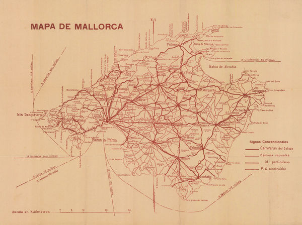
Libreria Escolar, Mallorca, 1933£ 145.00
-
George Philip & Son Ltd., Map of Tanganyika Territory, 1933£ 875.00
-
Ordnance Survey, Ordnance Survey Map of Jersey, 1933£ 395.00
-
Malmö Kartografiska Anstalt, Djurgarden, 1933 c£ 58.00
-
Malmö Kartografiska Anstalt, Malmo, 1933 c£ 55.00
-
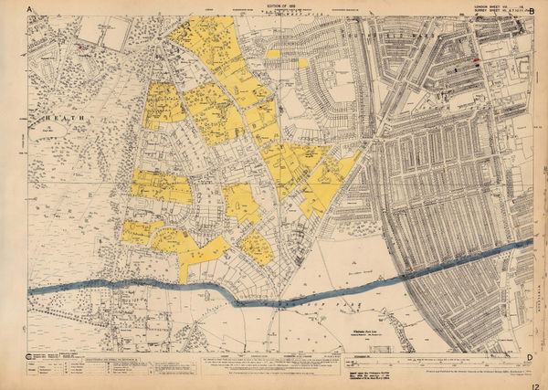
Ordnance Survey, Kings Cross and Angel, 1933 c.£ 1,150.00
-
Ordnance Survey, Southfields & Wimbledon, 1933 c.£ 745.00
-
Macdonald Gill, Map of Ceylon showing its Tea Industry, 1933 c.£ 175.00
-
Karl Baedeker, Miniature plan of Algiers, 1934£ 48.00
-
British Admiralty, Bingo Nada and Ozuchi Jima, 1934£ 495.00
-
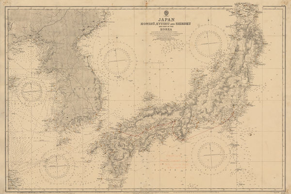
British Admiralty, Japan, Honshu, Kyushu & Shikoku and part of the Korea, 1934£ 895.00
-
British Admiralty, Malta and Gozo Islands, 1934£ 1,750.00
-
Mackay and Terry Expeditions in Western and Central Australia, 1934Royal Geographical Society (RGS)Series: LondonRoyal Geographical Society (RGS), Mackay and Terry Expeditions in Western and Central Australia, 1934£ 245.00
-
Luis de la Pena, Geological map of Spain and Portugal, 1934£ 325.00
-
Terry's Guide, Plan of Mazatlán, 1934£ 46.00
-
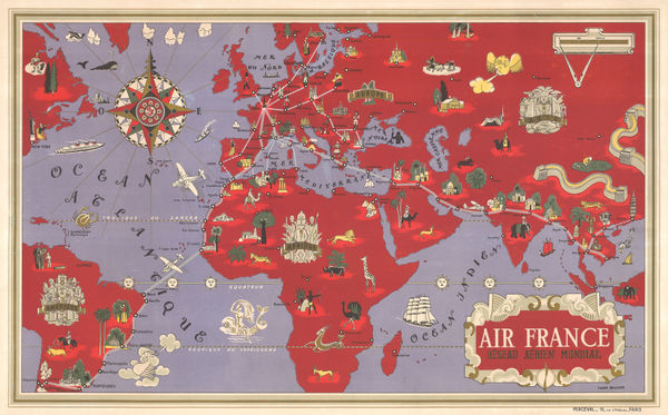
Air France, Air France - 'Reseau Aerien Mondial', 1934£ 3,500.00
-
John Power Studios, The Wonder Map of Melbourne, 1934£ 1,850.00
-
E. F. Hill, Map of the City of Santa Barbara, 1934£ 375.00
-
William Harding Thompson, Devon, 1934£ 125.00
-
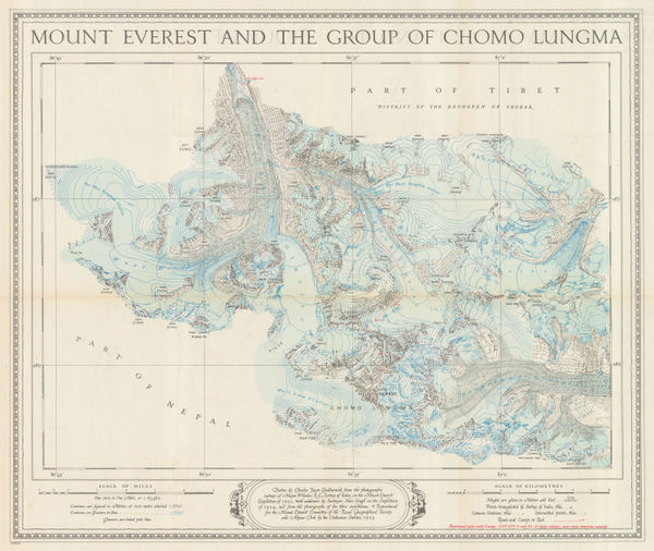
Ordnance Survey, Mount Everest and the Group of Chomo Lungma, 1934£ 1,500.00
-
Royal Geographical Society (RGS), Mt. Everest Flight 1933, 1934£ 245.00
-
Rex Whistler, Prospect of the City of London, 1934£ 3,250.00
-
Stations of the Falkland Island Sector / Stations of the Circumpolar Cruises, 1934Royal Geographical Society (RGS)Series: LondonRoyal Geographical Society (RGS), Stations of the Falkland Island Sector / Stations of the Circumpolar Cruises, 1934£ 450.00
-
Automobile Association (AA), Cardiff, 1934£ 125.00
-
John Bartholomew & Son, Baghdad, 1934£ 115.00
-
John Bartholomew & Son, Damascus, 1934£ 68.00
-
John Bartholomew & Son, Jerusalem, 1934£ 88.00
-
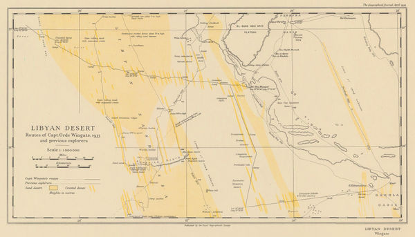
Royal Geographical Society (RGS), Orde Wingate's Egypt Expedition, 1934£ 175.00
-
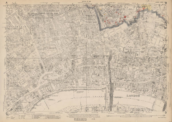
Ordnance Survey, East Central London, 1934 c.£ 1,150.00
-
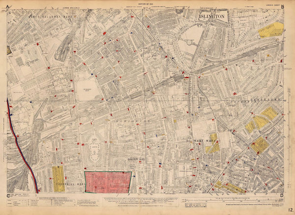
Ordnance Survey, Islington and Barnsbury, 1934 c.£ 925.00
-
Ernest Dudley Chase, A Pictorial Map of the British Isles, 1935£ 950.00
-
Institut géographique national (IGN), Aix, Provence, 1935£ 88.00
-
Walter Riemer, Romanian Map of Germany for the 1936 Berlin Olympics, 1935£ 750.00


Page
118
of 131